View - ResearchGate
View - ResearchGate
View - ResearchGate

You also want an ePaper? Increase the reach of your titles
YUMPU automatically turns print PDFs into web optimized ePapers that Google loves.
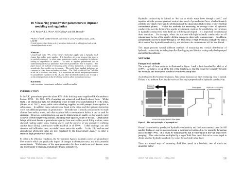
18 Measuring groundwater parameters to improvemodeling and regulationA.H. Parker*, L.J. West*, N.E.Odling* and S.H. Bottrell** School of Earth and Environment, University of Leeds, Woodhouse Lane, Leeds,LS2 9JT(E-mail a.parker@see.leeds.ac.uk, j.west@see.leeds.ac.uk. n.odling@see.leeds.ac.uk,s.bottrell@see.leeds.ac.uk)AbstractGroundwater forms 70% of the world’s freshwater supply, and is typically muchcleaner than surface water supplies. It is therefore a key water resource that needs tobe carefully managed. In urban areas, groundwater can be overexploited by industry,leading to degradation in quality. In order to regulate groundwater use, anunderstanding of the key parameters that control groundwater flow is required. Thispaper focuses on methods of measuring some of these parameters, so more accurategroundwater flow models can be created. The results from standard techniques arecompared to other, lower technology methods. The Chalk aquifer of East Yorkshirein the UK is used as a case study. It is hoped that the lessons and principals learnedby groundwater regulators in the UK and other developed countries can be used toavoid similar problems in the developing world as urban populations increase.Keywordswater resources, contaminants, pollution, modelling, qualityHydraulic conductivity is defined as “the rate at which water flows through a rock”, andtogether with the pressure gradient, controls the speed of groundwater flows, which ultimatelycontrols how much water can be abstracted and the speed and dilution rates of any potentialcontaminant plumes. Whilst the methods for measuring an average value of hydraulicconductivity over the depth of the aquifer are standard, methods for establishing the variationsin hydraulic conductivity with depth are still being developed. It is important to understandthese variations. For example, where the horizons with high hydraulic conductivity are allsituated near the top of the aquifer, drilling expensive, deep wells is unnecessary. In addition,contaminants can travel faster through a few thin zones of high hydraulic conductivity than athick zone of low hydraulic conductivity, and are hence the contaminants will be less diluted.This paper presents several different methods of measuring the vertical distribution ofhydraulic conductivity including impeller flow logging and dilution testing under both pumpedand ambient conditions.METHODSPumped well methodsThe principal of these methods is illustrated in figure 1 and is best described by Molz et al(1989). A pump is set up at the top of the borehole, so that the water flows radially towardsthe borehole, and then up the borehole towards the pump inlet.As depth down the borehole increases, fluid speed decreases as each producing zone is passed.If there is no ambient flow, the derivative of this log is proportional to hydraulic conductivity.INTRODUCTIONIn the UK, groundwater provides about 40% of the drinking water supplies (UK GroundwaterForum, 1998). By 2002, 10% of aquifers had urbanized land directly above them. Whilstthere is an increasing trend for abstracting water in rural areas and pumping it to the cities,(Morris et al, 2007), many public water drinking supplies are still pumped from aquifers inurban areas. In addition many industries are based in the cities, and their private abstractionwells put additional pressure on groundwater. Groundwater is usually considered to be muchcleaner than surface water, and often requires little or no treatment before it can be used fordrinking. However, overabstraction can lead to deterioration in quality, as low quality wateris drawn in from neighboring sources, including other aquifers, rivers or the sea. Urbanizationbrings additional threats to groundwater quality from sources like petrol filling stations, wastedisposal, leaking septic tanks, leaking sewers and the removal of any protective confiningaquifer layer during construction works (Aldrick et al 1999). Urban drainage can alsodecrease soil infiltration rates, so rainfall never enters the aquifer. In the UK, land use andgroundwater abstraction rates are now regulated by the Environment Agency in order tomaintain high groundwater quality.In order to be effective regulators, the Environment Agency maintain a series of groundwaterflow models which can predict the impact of changes in abstraction rates, and track potentialcontaminants. Whilst many of the input parameters for these models are well known, someare much harder to measure, including hydraulic conductivity.Figure 1 : The basic prinicples of a pumped testOverall transmissivity (product of hydraulic conductivity and thickness summed over the fullaquifer thickness) can be measured using a pumping test (detailed in, for example, Krusemanand de Ridder 1990). It is found by measurign the fall in water level in the well induced bypumping. This value is then multiplied by a log of fluid flow speed derivative versus depth toobtain absolute hydraulic conductivity values for each individual layer.There are several ways of measuring fluid flow speed in a borehole, two of which aredescribed below:WWW-YES 2008, Paris 13 – 16 May 2008 155WWW-YES 2008, Paris 13 – 16 May 2008 156
![[pastel-00730831, v1] Incidence des pratiques d'entretien ... - LEESU](https://img.yumpu.com/50938896/1/184x260/pastel-00730831-v1-incidence-des-pratiques-dentretien-leesu.jpg?quality=85)