MANAGEMENT PLAN FOR COMMUNITY LAND - City of Playford
MANAGEMENT PLAN FOR COMMUNITY LAND - City of Playford
MANAGEMENT PLAN FOR COMMUNITY LAND - City of Playford

Create successful ePaper yourself
Turn your PDF publications into a flip-book with our unique Google optimized e-Paper software.
<strong>MANAGEMENT</strong> <strong>PLAN</strong> <strong>FOR</strong> <strong>COMMUNITY</strong> <strong>LAND</strong>(Natural Area Wetland/Watercourse– Category 14 ReserveHierarchy)Plan Number 14.1/2004Refer Attachment – Schedule 1(Listing <strong>of</strong> Properties)DESCRIPTIONIdentity <strong>of</strong> land subject to this planRefer attachment – Schedule 2TENANCIESIdentity <strong>of</strong> tenants subject to this landRiverbanks Road Open SpaceLimavady Pty Ltd - agreement to occupy and use the land for horticultural purposes.PURPOSECouncil retains this land for the following purposesCouncil is required by Section 7 <strong>of</strong> the Local Government Act 1999 to “provide services andfacilities that benefit its area, its ratepayers and residents, and visitors to its area, includingamongst other things recreational facilities”.The land is retained by Council to provide passive and active recreation facilities for thecommunity and other visitors.Council may, grant a lease or licence <strong>of</strong> the whole or any part <strong>of</strong> the land during the life <strong>of</strong>this management plan for recreational activities, communication and service authorities (egTelstra, SA Water etc) requirements.The land has been classified as a “Natural Area Wetland/Watercourse- Category 14” inCouncil’s Reserve Hierarchy.Category 14.1
2OBJECTIVESThese are Council’s objectives for managing the landCouncil seeks to ensure that all <strong>of</strong> its assets are utilised to their maximum potential. Inparticular the land serves to meet Council’s desire that residents are able to partake in arange <strong>of</strong> activities to achieve a balanced life incorporating recreation opportunities. Theseobjectives are contained in Council’s “<strong>Playford</strong> Plan 2002 – 2012”.<strong>MANAGEMENT</strong> PROPOSALSThese are Council’s proposals for managing the landThe land comprises shelters, playgrounds, grassed areas, dry land areas and reservefurniture/infrastructure and the following will be undertaken:-SheltersShelters are regularly inspected by Council staff to check fittings and fixtures are in a safeand functional condition. Council processes defects reported by residents through theCouncil Customer Request System for follow up and repairs.Grassed AreasGrassed areas are currently equipped to satisfy the need <strong>of</strong> regular users. As required,controllers and sprinklers are replaced or repaired to maintain a service standard consistentwith its existing use. The sites are regularly mowed and watering occurs at a sustainable ratethat will be reviewed constantly in line with State Government water restriction policies.PlaygroundsPlay equipment is regularly inspected by Council staff to check fittings and fixtures are in asafe condition in accordance with Australian and New Zealand Standards As/NZS4486.1:1997. The s<strong>of</strong>t fall areas are inspected and cleaned regularly, raked and reinstated asrequired by Council.FootpathsFootpaths within these reserves are formed <strong>of</strong> concrete, paving or aggregate. Councilprocesses defects reported by residents through the Council Customer Request System forfollow up repairs as required.Creeks/WatercoursesCreeks/watercourses are regularly inspected by Council staff for the management <strong>of</strong> noxiousweeds, flammable undergrowth control, landscaping proposals and erosion control.Dry Land AreasCouncil will manage the dry land areas comprising trees/shrubs and grassed areas byreducing potential fire hazards and undertaking appropriate weed control measures.Reserve FurniturePark benches, litterbins, drinking fountains are common features within these reserves. Thisequipment is checked on a regular basis by Council staff to establish that the fixtures andfittings are sound and suit their use. Plumbing, painting and carpentry improvements will becarried out as required to ensure the functionality <strong>of</strong> these fixtures.Council recognises that an attractive facility will encourage increased patronage. AccordinglyCouncil implements a regular maintenance program for the land and when resources permitCategory 14.1
plan to upgrade and further develop the program.Council is required to upkeep the land to a standard in accordance with Council’s resources.Proposals affecting the management <strong>of</strong> the landAdams Creek Sanctuary, CraigmorePortion <strong>of</strong> the land is being developed and constructed as a flood mitigation dam.Jubilee Park, Elizabeth EastPortion <strong>of</strong> the land is being developed and constructed as a flood control capture basin.Olive Grove, Elizabeth ParkPortion <strong>of</strong> the land is being developed and constructed as wetland and Aquifer StorageRecharge (ASR) system.Other ReservesThere are no immediate plans to further develop other reserve land. However, as the land isretained by Council to provide passive and recreation activities for the community and othervisitors, Council may develop, modify or adapt the land by providing playgrounds, shelters,ovals, clubrooms, wetlands and any other form <strong>of</strong> recreational or community facility.3COUNCIL BY- LAWS AND POLICIESThe following Council by-laws and policies also effect how Council will manage this land- <strong>City</strong> <strong>of</strong> <strong>Playford</strong> By-Law No 2 - Moveable Signs- <strong>City</strong> <strong>of</strong> <strong>Playford</strong> By-Law No 3 - Local Government Land- <strong>City</strong> <strong>of</strong> <strong>Playford</strong> By-Law No 4 - DogsThe By Laws may be viewed at the Customer Service Centres located at:- <strong>Playford</strong> Library, Munno Para Shopping <strong>City</strong> Shop 51, 600 Main North Road,Smithfield- 10 <strong>Playford</strong> Boulevard, Elizabeth.Council’s endorsed Management Strategy for Parks and Reserves establishes policies,procedures and standards that will guide the future development, management andmaintenance <strong>of</strong> parks and reserves in the <strong>City</strong>.GOVERNMENT POLICIES AND <strong>PLAN</strong>SThe following State Government policies and plans concerning conservation anddevelopment relate to this landThe Development Plan governs what activities may occur on the land and how it may bedeveloped during the life <strong>of</strong> the Plan.Refer to the <strong>City</strong> <strong>of</strong> <strong>Playford</strong> Development Plan for applicable zoning.Category 14.1
4PER<strong>FOR</strong>MANCE APPRAISALCouncil will measure how it has managed the land in the following waysCouncil undertakes a regular community feedback survey that includes a request forresidents to comment on their views and experiences in using community land. Results <strong>of</strong> thesurvey are reported to Council.In addition Council invites people to comment to Council via its website, by post, facsimile, orin person at the Council <strong>of</strong>fices and by telephone.Council will record daily through its Customer Request System (CRS) all complaints andcompliments. Results from the CRS are reported regularly to Council.Council has adopted a performance management system to record successful achievement<strong>of</strong> service delivery. Regular assessment and reporting <strong>of</strong> compliance with Council’s assetmaintenance program is integral to this process.REVIEW AND AMENDMENT OF <strong>PLAN</strong>The plan will be reviewed within 5 years <strong>of</strong> its adoption and amended as soon as practicablebefore there is a substantial change to any element.Category 14.1
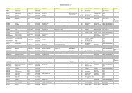
5Natural Area Wetland/Watercourse- Category 14 Reserve HierarchyPlan Number 14.1/2004SCHEDULE 1Angle ValeRiverbanks Road OpenSpaceBlakeviewFalcon Crescent/CraigmoreRoad WatercourseGrandview Place NorthWatercourseGrandview SouthWatercourseHay Crescent WatercourseNorman TerraceWatercoursePark Lake BoulevardReserveSmiths Creek SanctuaryBuckland ParkLegoe Road WetlandCraigmoreAdams CreekBeatrix ReserveCraigmore Park East -1Craigmore Park East -2.Craigmore Park – EastCraigmoreCraigmore Park WestCraigmore Park North WestWatercourseKaringa ReserveElizabeth DownsUley Park ReserveElizabeth EastJubilee ParkPipkin Road ReserveElizabeth ParkOlive GroveElizabeth ValeBoundary ParkHillbankCoach House Mews ReserveHighfield Drive WatercourseLandseer Place ReserveLittle Para River ReserveLittle Para River ReserveHumbug ScrubTaylor/Tenafeate ReserveOne Tree HillBlencowe ReservePrecolumb ReservePenfield GardensMcGee Road/Gawler RiverWatercourseSmithfieldLucy Street DrainageReserveMorialta Water courseSamuel Street DrainageReserveSmithfield PlainsCoventry Road DrainageReserveCrittenden Road DrainageReserveDavoren Road ScreeningReservePeachey Road DrainageReserveVirginiaGawler River/Baker RoadWatercourseCategory 14.1
7attached plan.Beatrix Reserve (102096)Lot 50 Deposited Plan 50237 being land contained in Certificate <strong>of</strong> Title 5592/752 adjacent IdaCourt, Beartix Drive and Uley Road as identified in the attached plan.Craigmore Park East (101688)Lot 38 Deposited Plan 40121 being land contained in Certificate <strong>of</strong> Title 5204/287 adjacentUley Road as identified in the attached plan.Craigmore Park East (100212, 101453, 101455, 101456, 101457, 101458, 101459, 101461,101462, 101463, 101478, 101490, 101621, 101622, 100268)Lots 212, 195, 208, 209, 210, 198, 213, 215, 216, 234, 235,151, 210, 211, Deposited Plans10533, 10532, 10534, 17664, 33088, 38944, being land contained in Certificate <strong>of</strong> Titles5553/408, 5553/409, 5632/614, 5553/414, 5632/678, 5553/413, 5632/677, 5632/676,5141/716, 5141/717, pt 5141/718, 5141/719 5300/963, 5166/484, 5553/411 adjacent UleyRoad, Birch Grove, Otama Court and Blair Park Drive as identified in the attached plan.Craigmore Park _ East CraigmoreLot 3005 Deposited Plan 72818, being land contained in Certificate <strong>of</strong> Title 5979/317 adjacentUley Road, Gloucester Drive and Chelmsford Drive as identified in the attached plan.Craigmore Park North East WatercourseLot 985 Deposited Plan 63471, being land contained in Certificate <strong>of</strong> Title 5908/875, adjacentChristine Circuit as identified in the attached plan.Craigmore Park West (100187, 100199, 100259, 101477, 101440, 101441, 101442, 101443,101444, 101445, 101446, 101482, 100241)Lots 501, 203, 207, 212, 112, 113, 114, 115, 116, 117, 118, 54, 211 Deposited Plans 23323,15993, 16301, 10490, 30080, 16301, being land contained in Certificate <strong>of</strong> Titles 5538/616,5538/930, 5538/957, 5680/570, 5552/527, 5632/675, 5552/455, 5632/673, 5552/454,5552/453, 5632/674, 5368/874, 5680/560 adjacent Blair Park Drive, Ironbark Avenue, AdamsRoad, Carob Crescent, and Admella Court as identified in the attached plan.Karinga Reserve (101464, 101465, 101691)Lots 1002, 656, 300 Deposited Plans 40601, 10905, 40277 being land contained in Certificate<strong>of</strong> Titles 5222/38, 5546/146, 5212/314, bounded by Yorktown Road, Luscombe Way, GapperCourt, Megunya Crescent and Karinga Avenue as identified in the attached plan.Elizabeth DownsUley Park Reserve (100247)Lot 803 Deposited Plan 7368 being land contained in Certificate <strong>of</strong> Title 5602/100 adjacentUley Road as identified in the attached planElizabeth EastJubilee Park (102019, 102026, 102027, 102029)Lots 231, 427, 230, 211 Deposited Plans 10661, 9368, 10661, 10660 being land contained inCertificate <strong>of</strong> Titles 5507/992, 5542/588, 5553/243, 5553/48 adjacent Seaborough Road,Seavington Road, Midway Road, and Jones Crescent as identified in the attached plan.Pipkin Road Reserve (102031, 101032)Lots 233, 301 Deposited Plans 10658, 10657 being land contained in Certificate <strong>of</strong> Titles5847/790, 5728/446 bounded by Pipkin Road, Kinkaid Road and Martin Road. as identified inthe attached plan.Elizabeth ParkOlive Grove (102015)Category 14.1
8Lot 4 Deposited Plan 6942, being land contained in Certificate <strong>of</strong> Title 2921/143 adjacentMidway Road, Shillabeer Road and Yorktown Road as identified in the attached plan.Elizabeth ValeBoundary Park (101874)Lot 1 Deposited Plan Deposited Plan 7068 being land contained in Certificate <strong>of</strong> Title 3315/102adjacent Coppleridge Drive, Shaftsbury Road and the Little Para River as identified in theattached plan.HillbankCoach House Mews ReserveLot 101 Deposited Plan 54011, being land contained in Certificate <strong>of</strong> Title 5737/924 adjacentCoach House Mews as identified in the attached plan.Highfield Drive WatercourseLot 666 Deposited Plan 43309, being land contained in Certificate <strong>of</strong> Title 5282/458 adjacentHighfield Drive as identified in the attached plan.Landseer Place ReserveLot 233 Deposited Plan 54010, being land contained in Certificate <strong>of</strong> Title 5737/945, adjacentLandseer Place as identified in the attached plan.Little Para River Reserve (101532, 101543)Lots 7, 4 Deposited Plans 10670, 34280, being land contained in Certificate <strong>of</strong> Titles 5740/786,5082/896 adjacent the Little Para River as identified in the attached plan.Little Para River ReserveLot 522 Deposited Plan 32670, being Crown Land in Crown Record 5477/175, owned by theCrown under Council’s care and control for reserve purposes bounded by Michael Crescent,Stephen Place, Main North Road and the Little Para River as identified in the attached plan.The Crown has no particular requirements over and above the purpose <strong>of</strong> the restrictionsplaced upon the Council by the dedication in regard to the dedication <strong>of</strong> the land.Humbug ScrubTaylor/Tenafeate ReserveSection 485 HD 105700, being Crown Land contained in Crown Records, 5752/710, owned bythe Crown under Council’s care and control for reserve purposes adjacent Taylor Road asidentified in the attached plan. The Crown has no particular requirements over and above thepurpose <strong>of</strong> the restrictions placed upon the Council by the dedication in regard to thededication <strong>of</strong> the land.One Tree HillBlencowe Reserve (100188)Sections 46, HD 105400 being Crown Land contained in Crown Records, 5764/791, owned bythe Crown under Council’s care and control for reserve purposes adjacent Blencowe Road asidentified in the attached plan. The Crown has no particular requirements over and above thepurpose <strong>of</strong> the restrictions placed upon the Council by the dedication in regard to thededication <strong>of</strong> the land.Precolumb Reserve (100181)Sections 45, HD 105400 being Crown Land contained in Crown Records, 5764/790, owned bythe Crown under Council’s care and control for reserve purposes adjacent One Tree Hill Roadand Precolumb Road as identified in the attached plan. The Crown has no particularrequirements over and above the purpose <strong>of</strong> the restrictions placed upon the Council by thededication in regard to the dedication <strong>of</strong> the land.Penfield GardensCategory 14.1
9McGee Road/Gawler River WatercourseLot 3 Deposited Plan 25326, being land contained in Certificate <strong>of</strong> Title 5886/302 adjacentMcGee Road and the Gawler River as identified in the attached plan.SmithfieldLucy Street Drainage Reserve (100157 101829)Lot, 5 Deposited Plan 61766 being land contained in Certificate <strong>of</strong> Titles 5896/128 adjacent therailway line, Lucy Street, Rose Street and Samuel as identified in the attached plan.Morialta WatercourseLot 124 Deposited Plan 66298, Being land contained in Certificate <strong>of</strong> Title 5935/930 adjacentMorialta Drive and Main North Road as identified in the attached plan.Samuel Street Drainage Reserve (100162, 100326, 101513, 101549)Lots 15, 4, 3, 90 Deposited Plans 10802, 9398, 34763, 9004 being land contained inCertificate <strong>of</strong> Titles 5552/417, 5431/440, 5085/36, 5882/38 adjacent, Samuel Street, CurtisRoad and Coventry Road as identified in the attached plan.Smithfield PlainsCoventry Road Drainage Reserve (101306, 101307)Lots 16, 88 Deposited Plans 7869, 7870 being land contained in Certificate <strong>of</strong> Titles 5882/35,5882/36 adjacent Coventry Road, Heddle Street and Peachey Road as identified in theattached plan.Crittenden Road Drainage ReserveLot 685 Deposited Plan 9050, being lanf contained in Certificate <strong>of</strong> Title 5882/40, adjacentCrittenden Road and Stebonheath Road as identified in the attached plan.Davoren Road Screening Reserve (101548,100150)Lots 393, 2, 3, 4 Deposited Plans 7889, 21806 being land contained in Certificate <strong>of</strong> Titles5882/37, 5441/611 adjacent Conventry and Davoren Road as identified in the attached plan.Peachey Road Drainage Reserve (101679)Lot 764 Deposited Plans 9101, 9102 being land contained in Certificate <strong>of</strong> Titles 5882/47adjacent Peachey Road and Featherstone Street as identified in the attached plan.VirginiaGawler River/Baker Road WatercourseLot 102 Deposited Plan 18067, being land contained in Certificate <strong>of</strong> Title 5539/905 adjacentBaker Road and the Gawler River as identified in the attached plan.Category 14.1