CYCLE NETWORK AND ROUTE PLANNING GUIDE
CYCLE NETWORK AND ROUTE PLANNING GUIDE
CYCLE NETWORK AND ROUTE PLANNING GUIDE

You also want an ePaper? Increase the reach of your titles
YUMPU automatically turns print PDFs into web optimized ePapers that Google loves.
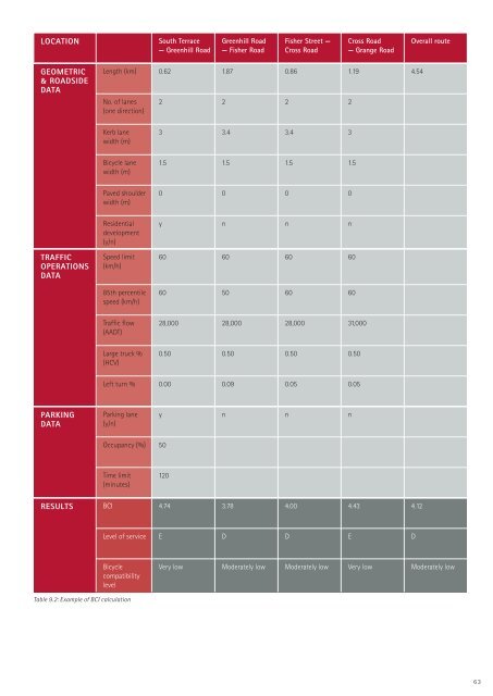
LOCATIONSouth Terrace— Greenhill RoadGreenhill Road— Fisher RoadFisher Street —Cross RoadCross Road— Grange RoadOverall routeGEOMETRIC& ROADSIDEDATALength (km) 0.62 1.87 0.86 1.19 4.54No. of lanes(one direction)2 2 2 2Kerb lanewidth (m)3 3.4 3.4 3Bicycle lanewidth (m)1.5 1.5 1.5 1.5Paved shoulderwidth (m)0 0 0 0TRAFFICOPERATIONSDATAResidentialdevelopment(y/n)Speed limit(km/h)85th percentilespeed (km/h)y n n n60 60 60 6060 50 60 60Traffic flow(AADT)28,000 28,000 28,000 31,000Large truck %(HCV)0.50 0.50 0.50 0.50Left turn % 0.00 0.09 0.05 0.05PARKINGDATAParking lane(y/n)y n n nOccupancy (%) 50Time limit(minutes)120RESULTS BCI 4.74 3.78 4.00 4.43 4.12Level of service E D D E DBicyclecompatibilitylevelVery low Moderately low Moderately low Very low Moderately lowTable 9.2: Example of BCI calculation63