A late report — another universityhonours a geologistFor various reasons this piece<strong>of</strong> news, <strong>of</strong> minor historicalsignificance, has escaped thenotice <strong>of</strong> most <strong>Australia</strong>ngeologists. It happened about ayear ago on 3 February 2012.<strong>Australia</strong>n universities havebeen slow to commemorategeologists who have taught at orattended particular establishments.The University <strong>of</strong> Sydneyerected a ‘custom-built’ GeologySchool in 1960, named forEdgeworth David, and proceededto demolish it in 2005 to make wayfor a new Law School. Fortunately, on this second occasion it took thedesires <strong>of</strong> David’s then living grand-daughter to rename ‘Old Geology’the ‘Edgeworth David Building’. This was an appropriate enough move,seeing that David had been instrumental in its planning and constructionin 1895. An earlier distinguished former Pr<strong>of</strong>essor <strong>of</strong> Geology, ArchibaldLiversidge, continues to get the cold shoulder at the university.I’m not sure if the building at the University <strong>of</strong> New England namedfor Leo Cotton by the first Pr<strong>of</strong>essor <strong>of</strong> Geology, Alan Voisey, at the timeUNE cut its ties with Sydney, still exists. Dorothy Hill at least has a libraryin her name at Queensland, and <strong>of</strong> course, Douglas Mawson is honouredat Adelaide. I think McCoy gets a mention at Melbourne, and Woolnoughlikewise at WA.However the 2012 naming was quite different for it took place at auniversity that teaches little or no science, let alone geology. So what isthe link?The name is the Tenison Woods House <strong>of</strong> the <strong>Australia</strong>n CatholicUniversity, at its North Sydney (MacKillop) Campus. The link is, <strong>of</strong> coursesimple. Julian Edmund Tenison Woods (1832–1889), a Catholic priest,when in South <strong>Australia</strong> was the mentor <strong>of</strong> the young Mary MacKillopin her early years founding the Sisters <strong>of</strong> St Joseph (1866), an orderdesigned to ensure education <strong>of</strong> the underprivileged.Woods needs little introduction to those familiar with his <strong>Australia</strong>ngeology work, which notably included karst, volcanic and metamorphicstudies in South <strong>Australia</strong>, and mineral studies in the Northern Territory,Malaya (as it then was) and Japan.The fine, renovated numerous-storey building was given a goodopening, thanks to the local member, Joe Hockey, and also received areligious blessing at the hand <strong>of</strong> Cardinal Pell. There was a certain ironyin the latter event, as Woods was somewhat on the outer with thechurch hierarchy at the time <strong>of</strong> his death in 1889, although CardinalMoran did preside at his funeral Mass at St Marys Cathedral. Howevertime has seen him well and truly rehabilitated!Descendants <strong>of</strong> Woods’s brother and several <strong>of</strong> his biographersattended the 2012 renaming ceremony.DAVID BRANAGANCase studies sought fortext book supplementDear Geoscience Colleagues,The highly successful Teacher Earth Science Education Programme(TESEP) is seeking your assistance.We are collaborating with Earth Science Western <strong>Australia</strong> (ESWA)to produce case studies that complement their fantastic Earth andEnvironmental Science (EES) text book.By updating with <strong>Australia</strong>-wide examples, the book will moreeffectively help all <strong>Australia</strong>n teachers when the new <strong>Australia</strong>nCurriculum EES course for Years 11–12 is rolled out in a few years. TESEPis encouraging nationwide adoption <strong>of</strong> this text. By providing additionalcomplementary case studies we are helping to ensure it is <strong>of</strong> maximumuse across the country.The book has 19 chapters and we are looking for excellent <strong>Australia</strong>nexamples for many areas <strong>of</strong> text. Each case study will consist <strong>of</strong> two tosix pages including research, diagrams, maps and activities. The chaptersaddress minerals, fossils, geological time, plate tectonics, geohazards,energy, resources and the three rock types. Chapters also embrace soils,water, weather, climate change, human activity, ecosystems andbio-diversity. A complete overview is available on the TESEP website athttp://www.tesep.org.au/casestudies.html.However, we are not seeking to rewrite the curriculum! You maythink there are sections <strong>of</strong> the book missing but it is written to meetthe WA EES curriculum requirements. It will also be revised to meet thenational EES curriculum even better in due course, but either way it willnot cover all possible content. Consequently, if you think you havematerial that does not fit the chapter headings do not be discouraged.The content touched on under those headings is wide-ranging and manyless-obvious connections can be made as a result.I will be personally contacting those in the geoscience communityI know may be able to provide or easily develop some <strong>of</strong> the materialrequired — but I encourage one and all to help.If you have anything <strong>of</strong> your own or are aware <strong>of</strong> materials thatmight suit our needs please contact me as soon as possible. Obviously,we need to be sure that there are no copyright restrictions on thematerials you provide. However, even if you contribute just one classicphoto <strong>of</strong> a particular geological phenomenon, the <strong>Australia</strong>n teachingfraternity and all future students will be very grateful and yourcontribution will be acknowledged.Needless to say, in order to ensure national appeal the case studieswill need to have national geographic spread. This means we may havethe unenviable task <strong>of</strong> choosing some over others for the first batch <strong>of</strong>case studies that we hope to have finalised by October 2013. However,since the case studies are likely to be delivered online we should be ableto continually add them to the ESWA and TESEP websites as they arewritten up and inform teachers by email and newsletters.GREG MCNAMARAExecutive Officer <strong>of</strong> the Teacher Earth ScienceEducation ProgrammeEmail eo@tesep.org.auMobile 0412 211 797<strong>TAG</strong> March 2013| 19
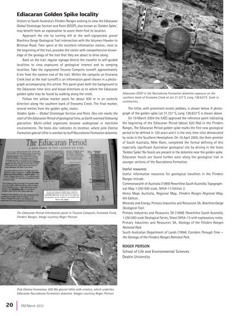
Ediacaran Golden Spike localityVisitors to South <strong>Australia</strong>’s Flinders Ranges wishing to view the EdiacaranGlobal Stratotype Section and Point (GSSP), also known as ‘Golden Spike’,may benefit from an explanation to assist them find its location.Approach the site by turning left at the well-signposted, gravelBrachina Gorge <strong>Geological</strong> Trail intersection with the bitumen Hawker toBlinman Road. Time spent at the excellent information station, close tothe beginning <strong>of</strong> the trail, provides the visitor with comprehensive knowledge<strong>of</strong> the geology <strong>of</strong> the trail that they are about to drive along.Back on the trail, regular signage directs the traveller to self-guidedlocalities to view exposures <strong>of</strong> geological interest and to campinglocalities. Take the signposted Trezona Campsite turn<strong>of</strong>f, approximately6 km from the eastern end <strong>of</strong> the trail. Within the campsite on EnoramaCreek (not at the trail turn<strong>of</strong>f) is an information panel shown in a photographaccompanying this article. This panel gives both the background tothe Ediacaran time-slice and broad directions as to where the Ediacarangolden spike may be found by walking along the creek.Follow the yellow marker posts for about 500 m in an easterlydirection along the southern bank <strong>of</strong> Enorama Creek. The final marker,several metres from the golden spike, states:Golden Spike — Global Stratotype Section and Point. Geo site marks thestart <strong>of</strong> the Ediacaran Period <strong>of</strong> geological time, as Earth warmed followingglaciation. Multi-celled organisms became widespread in maritimeenvironments. The brass disc indicates its location, where pink ElatinaFormation glacial tillite is overlain by buff Nuccaleena Formation dolomite.The Ediacaran Period information panel in Trezona Campsite, Enorama Creek,Flinders Ranges. Image courtesy Roger Pierson.Ediacaran GSSP in the Nuccaleena Formation dolomite exposure on thesouthern bank <strong>of</strong> Enorama Creek at Lat 31.331°S, Long 138.633°E. Scale incentimetres.The tillite, with prominent erratic pebbles, is shown below. A photograph<strong>of</strong> the golden spike Lat 31.331°S, Long 138.633°E is shown above.On 19 March 2004 the IUGS approved the reference point indicatingthe beginning <strong>of</strong> the Ediacaran Period (about 620 Ma) in the FlindersRanges. The Ediacaran Period golden spike marks the first new geologicalperiod to be defined in 120 years and it is the only time-slice demarcatedby rocks in the Southern Hemisphere. On 16 April 2005, the then-premier<strong>of</strong> South <strong>Australia</strong>, Mike Rann, completed the formal defining <strong>of</strong> thisespecially significant <strong>Australia</strong>n geological site by driving in the brass‘Golden Spike’. No fossils are present in the dolomite near the golden spike.Ediacaran fossils are found further west along the geological trail inyounger sections <strong>of</strong> the Nuccaleena Formation.Useful resourcesUseful information resources for geological travellers in the FlindersRanges include:Commonwealth <strong>of</strong> <strong>Australia</strong> (1999) Parachilna South <strong>Australia</strong>, TopographicalMap 1:250 000 scale, SH54-13 Edition 2.Hema Maps <strong>Australia</strong>, Regional Map, Flinders Ranges Regional Map,4th Edition.Minerals and Energy, Primary Industries and Resources SA, Brachina Gorge<strong>Geological</strong> Trail.Primary Industries and Resources SA (1999) Parachilna South <strong>Australia</strong>,1:250 000 scale <strong>Geological</strong> Series, Sheet SH54-13 with explanatory notes.Primary Industries and Resources SA, Geology <strong>of</strong> the Flinders RangesNational Park.South <strong>Australia</strong>n Department <strong>of</strong> Lands (1994) Corridors Through Time —the Geology <strong>of</strong> the Flinders Ranges National Park.ROGER PIERSONSchool <strong>of</strong> Life and Environmental SciencesDeakin UniversityPink Elatina Formation, 620 Ma glacial tillite with erratics, which underliesEdiacaran Nuccaleena Formation dolomite. Images courtesy Roger Pierson.20 |<strong>TAG</strong> March 2013