China, <strong>Australia</strong> and geoparksLate last year, I had the privilege to visit China’s latest global geopark —Tianzhushan (Tianzhu Mountain) in Anhui Province, west <strong>of</strong> Shanghai.Tianzhushan is a truly amazing natural heritage icon <strong>of</strong> world-classstanding. With spectacular and breathtaking scenery underpinned by acomplex granite and metamorphic landscape, this geopark is unique in theworld. An outstanding feature <strong>of</strong> the geopark is the design and construction<strong>of</strong> an extensive network <strong>of</strong> walkways and other essential infrastructurethat immerse the visitor into the landscape and geology <strong>of</strong> Tianzhushan,the centrepiece <strong>of</strong> the geopark, but without detracting in any way fromthe visual amenity <strong>of</strong> the visitor experience. This feature is worthy <strong>of</strong> aglobal park design award, but significantly it is also a lasting tribute to thevast amount <strong>of</strong> human effort that was required to construct these worksand the absolute dedication <strong>of</strong> the local community to put in place accessto the landscape for the world community.Also visited was the Valley Stream cultural park, which featured wellprotectedcarved stone relics, with the constructed tourist facilities totallyharmonious with the natural environment. On display in nearby QianshanCounty Museum were unearthed stone tools, pottery, bronze and fossils.A ‘global geopark’, as defined by UNESCO, is a unified area withgeological heritage <strong>of</strong> international significance. It is a concept thatenhances ‘branding’ <strong>of</strong> natural areas for tourism purposes. A geopark isnot part <strong>of</strong> a designated land system that creates public reserves aimed atprotecting or preserving natural heritage.Currently there are 90 global geoparks — a large number <strong>of</strong> which arein China — spread across 27 countries forming part <strong>of</strong> the Global GeoparkNetwork (GGN). The GGN is a growing movement that is perceived by hostcountries as a key driver <strong>of</strong> global ‘geotourism’.In 2011, the GSA established a Geotourism Subcommittee <strong>of</strong> theStanding Committee for <strong>Geological</strong> Heritage to advance and promotegeotourism development in <strong>Australia</strong>, and to raise public awareness andappreciation <strong>of</strong> geodiversity. Although the issue <strong>of</strong> the future <strong>of</strong> geoparkshas not been formally included within the Subcommittee’s charter, it isrecognised that some members <strong>of</strong> the Geotourism Subcommittee are ableto provide advice about ‘geopark’ development in <strong>Australia</strong>.The Subcommittee is very mindful that a November 2009 resolution<strong>of</strong> <strong>Australia</strong>n Government Ministers for the Environment (EPHC) hasdetermined that existing mechanisms are considered sufficient to protectgeoheritage in <strong>Australia</strong>. After consultation with Resource ManagementMinisters, EPHC has expressed significant concerns with the application<strong>of</strong> the UNESCO geoparks concept in <strong>Australia</strong>, especially without governmentendorsement. <strong>Australia</strong>’s only attempt to establish a global geopark,which embraces parts <strong>of</strong> Victoria and South <strong>Australia</strong> (Kanawinka), hasnot been approved by the <strong>Australia</strong>n Government. Kanawinka Geopark hasrecently been delisted from the GGN.Nevertheless, the Geotourism Subcommittee has also recognised thatthere is an opportunity to foster and promote geotourism initiatives within<strong>Australia</strong>’s 16 designated National Landscapes with geological andgeomorphological significance, as a model for advancing geotourism andgeoheritage considerations in other regions.ANGUS M ROBINSONChair, GeotourismSubcommitteeChina’s latest global geopark — Tianzhushan in Anhui Province. Imagecourtesy Xu Dian.Fossil problematica fromMoreton National Park, NSWI’m seeking assistance with a tricky fossil found in Moreton National Park,NSW.Some time ago I was shown some unusual structures on the surface<strong>of</strong> steeply dipping arenaceous rocks in Moreton National Park. Thesetightly folded metasediments are Late Ordovician in age and locally formthe basement to Permian sandstones <strong>of</strong> the Sydney Basin.The patterns on the rock surface (see photographs below) suggestedto me that they might be <strong>of</strong> organic origin.I am also aware that they may simply represent some kind <strong>of</strong> solemarkings on the sedimentary bed.If they are organic in origin, could they be imprints left by some form<strong>of</strong> sedentary sponge-like animal living in a deep-sea environment?Graptolites are found in the Upper Ordovician rock sequence in thissoutheast region <strong>of</strong> NSW but they are confined to black slate horizons.They provide the only other fossil evidence in the Upper Ordovicianmetasediments.If you think you can assist, please contact me.PHIL SMARTRetired Member GSA, Volunteer Fossil Walk Leaderand Discovery Ranger with National Parks NSWinfo@145ontheparade.com.au. Telephone 0408 588 <strong>166</strong>Structures found in sediments in Moreton National Park, NSW.Negative image <strong>of</strong> structures found in sediments in Moreton National Park,NSW. Images courtesy Phil Smart.<strong>TAG</strong> March 2013| 21
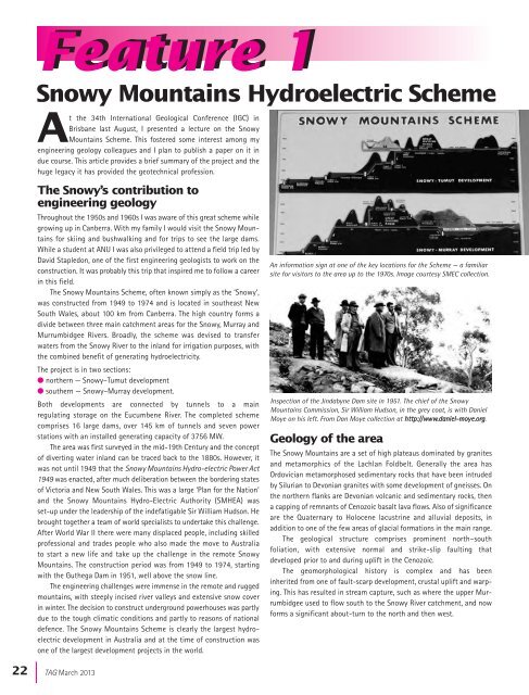
Feature 1Feature 1Snowy Mountains Hydroelectric SchemeAt the 34th International <strong>Geological</strong> Conference (IGC) inBrisbane last August, I presented a lecture on the SnowyMountains Scheme. This fostered some interest among myengineering geology colleagues and I plan to publish a paper on it indue course. This article provides a brief summary <strong>of</strong> the project and thehuge legacy it has provided the geotechnical pr<strong>of</strong>ession.The Snowy’s contribution toengineering geologyThroughout the 1950s and 1960s I was aware <strong>of</strong> this great scheme whilegrowing up in Canberra. With my family I would visit the Snowy Mountainsfor skiing and bushwalking and for trips to see the large dams.While a student at ANU I was also privileged to attend a field trip led byDavid Stapledon, one <strong>of</strong> the first engineering geologists to work on theconstruction. It was probably this trip that inspired me to follow a careerin this field.The Snowy Mountains Scheme, <strong>of</strong>ten known simply as the ‘Snowy’,was constructed from 1949 to 1974 and is located in southeast NewSouth Wales, about 100 km from Canberra. The high country forms adivide between three main catchment areas for the Snowy, Murray andMurrumbidgee Rivers. Broadly, the scheme was devised to transferwaters from the Snowy River to the inland for irrigation purposes, withthe combined benefit <strong>of</strong> generating hydroelectricity.The project is in two sections:l northern — Snowy–Tumut developmentl southern — Snowy–Murray development.Both developments are connected by tunnels to a mainregulating storage on the Eucumbene River. The completed schemecomprises 16 large dams, over 145 km <strong>of</strong> tunnels and seven powerstations with an installed generating capacity <strong>of</strong> 3756 MW.The area was first surveyed in the mid-19th Century and the concept<strong>of</strong> diverting water inland can be traced back to the 1880s. However, itwas not until 1949 that the Snowy Mountains Hydro-electric Power Act1949 was enacted, after much deliberation between the bordering states<strong>of</strong> Victoria and New South Wales. This was a large ‘Plan for the Nation’and the Snowy Mountains Hydro-Electric Authority (SMHEA) wasset-up under the leadership <strong>of</strong> the indefatigable Sir William Hudson. Hebrought together a team <strong>of</strong> world specialists to undertake this challenge.After World War II there were many displaced people, including skilledpr<strong>of</strong>essional and trades people who also made the move to <strong>Australia</strong>to start a new life and take up the challenge in the remote SnowyMountains. The construction period was from 1949 to 1974, startingwith the Guthega Dam in 1951, well above the snow line.The engineering challenges were immense in the remote and ruggedmountains, with steeply incised river valleys and extensive snow coverin winter. The decision to construct underground powerhouses was partlydue to the tough climatic conditions and partly to reasons <strong>of</strong> nationaldefence. The Snowy Mountains Scheme is clearly the largest hydroelectricdevelopment in <strong>Australia</strong> and at the time <strong>of</strong> construction wasone <strong>of</strong> the largest development projects in the world.An information sign at one <strong>of</strong> the key locations for the Scheme — a familiarsite for visitors to the area up to the 1970s. Image courtesy SMEC collection.Inspection <strong>of</strong> the Jindabyne Dam site in 1951. The chief <strong>of</strong> the SnowyMountains Commission, Sir William Hudson, in the grey coat, is with DanielMoye on his left. From Dan Moye collection at http://www.daniel-moye.org.Geology <strong>of</strong> the areaThe Snowy Mountains are a set <strong>of</strong> high plateaus dominated by granitesand metamorphics <strong>of</strong> the Lachlan Foldbelt. Generally the area hasOrdovician metamorphosed sedimentary rocks that have been intrudedby Silurian to Devonian granites with some development <strong>of</strong> gneisses. Onthe northern flanks are Devonian volcanic and sedimentary rocks, thena capping <strong>of</strong> remnants <strong>of</strong> Cenozoic basalt lava flows. Also <strong>of</strong> significanceare the Quaternary to Holocene lacustrine and alluvial deposits, inaddition to one <strong>of</strong> the few areas <strong>of</strong> glacial formations in the main range.The geological structure comprises prominent north–southfoliation, with extensive normal and strike-slip faulting thatdeveloped prior to and during uplift in the Cenozoic.The geomorphological history is complex and has beeninherited from one <strong>of</strong> fault-scarp development, crustal uplift and warping.This has resulted in stream capture, such as where the upper Murrumbidgeeused to flow south to the Snowy River catchment, and nowforms a significant about-turn to the north and then west.22 |<strong>TAG</strong> March 2013