News letter Dam edition
News letter Dam edition
News letter Dam edition
- No tags were found...

Create successful ePaper yourself
Turn your PDF publications into a flip-book with our unique Google optimized e-Paper software.
Ingeokring <strong>News</strong><strong>letter</strong><br />
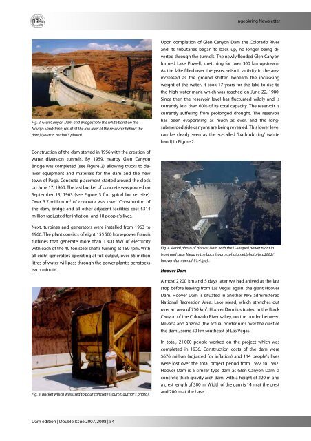
Fig. 2 Glen Canyon <strong>Dam</strong> and Bridge (note the white band on the<br />
Navajo Sandstone, result of the low level of the reservoir behind the<br />
dam) (source: author’s photo).<br />
Upon completion of Glen Canyon <strong>Dam</strong> the Colorado River<br />
and its tributaries began to back up, no longer being diverted<br />
through the tunnels. The newly flooded Glen Canyon<br />
formed Lake Powell, stretching for over 300 km upstream.<br />
As the lake filled over the years, seismic activity in the area<br />
increased as the ground shifted beneath the increasing<br />
weight of the water. It took 17 years for the lake to rise to<br />
the high water mark, which was reached on June 22, 1980.<br />
Since then the reservoir level has fluctuated wildly and is<br />
currently less than 60% of its total capacity. The reservoir is<br />
currently suffering from prolonged drought. The reservoir<br />
has been evaporating as much as ever, and the longsubmerged<br />
side canyons are being revealed. This lower level<br />
can be clearly seen as the so-called ‘bathtub ring’ (white<br />
band) in Figure 2.<br />
Construction of the dam started in 1956 with the creation of<br />
water diversion tunnels. By 1959, nearby Glen Canyon<br />
Bridge was completed (see Figure 2), allowing trucks to deliver<br />
equipment and materials for the dam and the new<br />
town of Page. Concrete placement started around the clock<br />
on June 17, 1960. The last bucket of concrete was poured on<br />
September 13, 1963 (see Figure 3 for typical bucket size).<br />
Over 3.7 million m 3 of concrete was used. Construction of<br />
the dam, bridge and all other adjacent facilities cost $314<br />
million (adjusted for inflation) and 18 people’s lives.<br />
Next, turbines and generators were installed from 1963 to<br />
1966. The plant consists of eight 155 500 horsepower Francis<br />
turbines that generate more than 1 300 MW of electricity<br />
with each of the 40 ton steel shafts turning at 150 rpm. With<br />
all eight generators operating at full output, over 55 million<br />
litres of water will pass through the power plant's penstocks<br />
each minute.<br />
Fig. 4 Aerial photo of Hoover <strong>Dam</strong> with the U-shaped power plant in<br />
front and Lake Mead in the back (source: photo.net/photo/pcd2882/<br />
hoover-dam-aerial-91.4.jpg) .<br />
Hoover <strong>Dam</strong><br />
Almost 2 200 km and 5 days later we had arrived at the last<br />
stop before leaving from Las Vegas again: the giant Hoover<br />
<strong>Dam</strong>. Hoover <strong>Dam</strong> is situated in another NPS administered<br />
National Recreation Area: Lake Mead, which stretches out<br />
over an area of 750 km 2 . Hoover <strong>Dam</strong> is situated in the Black<br />
Canyon of the Colorado River valley, on the border between<br />
Nevada and Arizona (the actual border runs over the crest of<br />
the dam), some 50 km southeast of Las Vegas.<br />
Fig. 3 Bucket which was used to pour concrete (source: author’s photo).<br />
In total, 21 000 people worked on the project which was<br />
completed in 1936. Construction costs of the dam were<br />
$676 million (adjusted for inflation) and 114 people’s lives<br />
were lost over the total project period from 1922 to 1942.<br />
Hoover <strong>Dam</strong> is a similar type dam as Glen Canyon <strong>Dam</strong>, a<br />
concrete thick gravity arch dam, with a height of 220 m and<br />
a crest length of 380 m. Width of the dam is 14 m at the crest<br />
and 200 m at the base.<br />
<strong>Dam</strong> <strong>edition</strong> | Double Issue 2007/2008 | 54