News letter Dam edition
News letter Dam edition
News letter Dam edition
- No tags were found...

Create successful ePaper yourself
Turn your PDF publications into a flip-book with our unique Google optimized e-Paper software.
Ingeokring <strong>News</strong><strong>letter</strong><br />
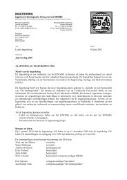
Hungry Horse <strong>Dam</strong><br />
On the road from Kalispell to Glacier National Park, I stopped<br />
along the road for a view of the Hungry Horse <strong>Dam</strong>. This<br />
dam is a concrete thick arch dam, located in a narrow canyon<br />
in the Flathead River, near Columbia Falls in Montana.<br />
Construction started in 1948 and at the time of its completion<br />
in 1953, the dam was the third largest dam, and the<br />
second highest concrete dam, in the world. Currently, it is<br />
the largest dam in Montana and nr. 11 in the list of largest<br />
concrete dams in the USA.<br />
situated in the Columbia River near the towns of Grand Coulee<br />
and Electric City. The dam is part of Lake Roosevelt National<br />
Recreation Area, administered by the National Park<br />
Service. The dam itself is operated by the U.S. Bureau of Reclamation.<br />
Grand Coulee <strong>Dam</strong>, with its three powerhouses, forms the<br />
largest hydro-electric project in the USA and the fourth largest<br />
in the world. It is the largest concrete structure in the<br />
USA, with 9.16 million m 3 of concrete used. Crest length of<br />
the dam is 1 592 m, while its height is 168 m. Base width is<br />
152 m and crest width is 9 m.<br />
Construction of the original project started in December<br />
1933, as part of the Columbia Basin Project for irrigation of<br />
desert areas of the Pacific Northwest and for the production<br />
of electricity for the then rapidly expanding cities of Spokane,<br />
Portland, Seattle and Tacoma. Foundation rocks at the<br />
dam site consist of hard, sound, massive granite varying<br />
from coarse-grained in the right abutment to fine-grained<br />
porphyritic in the left abutment.<br />
Fig. 7 View on Hungry Horse <strong>Dam</strong> from the road between Columbia<br />
Falls and Glacier National Park (source: author’s photo).<br />
The 172 m high dam is a variable-thickness concrete arch<br />
structure with a crest length of 645 m. Crest width is 10 m,<br />
base width 98 m. The dam and appurtenant works contain<br />
2.4 million m 3 of concrete. The spillway is the highest morning-glory<br />
structure in the world. Water cascading over the<br />
spillway rim drops a maximum distance of 149 m. The capacity<br />
of the spillway is 1 415 m 3 per second, and the reservoir<br />
has a total surface area of 96 km 2 .<br />
Construction finished in 1942, and numerous modifications<br />
followed in more recent years. The first power was generated<br />
in 1941 and the last of the original 18 units (of the initial<br />
two powerhouses, one at each side of the dam’s spillway)<br />
started production in 1950. Between 1966 and 1974<br />
the dam was expanded to add the Third Powerhouse. The<br />
original dam was modified for the Third Powerhouse by a<br />
357 m long, 61 m high forebay dam along the right abutment<br />
approximately parallel to the river and at an angle of<br />
64 degrees to the axis of Grand Coulee <strong>Dam</strong>. This involved<br />
demolishing 80 m of the northeast side of the dam. The<br />
addition accommodates six new generators. These new<br />
turbines and generators, three 600 MW and three 805 MW<br />
The dam is used for power generation, using 71 MW generators.<br />
The generator capacity was upgraded in the 1990´s to<br />
107 MW each, for a total plant capacity of 428 MW. The<br />
dam’s foundation consists of Siyeh Limestone in regular<br />
beds ranging from a few centimetres to metres thick, made<br />
highly insoluble by impurities. Cut by one major and several<br />
minor shear zones, and one major bedding-plane slip.<br />
Grand Coulee <strong>Dam</strong><br />
After Hungry Horse <strong>Dam</strong>, I travelled through Canada for two<br />
weeks and after that I went south again and visited the<br />
beautiful northeastern part of the state of Washington. After<br />
crossing the border between the USA and Canada, I went to<br />
the giant Grand Coulee <strong>Dam</strong>. This is a concrete gravity dam,<br />
Fig. 8 Grand Coulee <strong>Dam</strong>, with Right and Left Powerplants at both<br />
sides of the spillway and Third Powerhouse and Forebay <strong>Dam</strong> at the left<br />
side (source: U.S. Bureau of Reclamation).<br />
<strong>Dam</strong> <strong>edition</strong> | Double Issue 2007/2008 | 56