

Loddon Tracks and Trails Strategy - Loddon Shire Council
Loddon Tracks and Trails Strategy - Loddon Shire Council
Loddon Tracks and Trails Strategy - Loddon Shire Council

You also want an ePaper? Increase the reach of your titles
YUMPU automatically turns print PDFs into web optimized ePapers that Google loves.
3.0 Local Context<br />
A range of local <strong>and</strong> state level documents have been reviewed in order to underst<strong>and</strong><br />
the policy context in which tracks <strong>and</strong> trails have been or are proposed to be developed.<br />
A summary of the information sourced from community plans follows, <strong>and</strong> a detailed<br />
description of the literature review is included in the Appendix.<br />
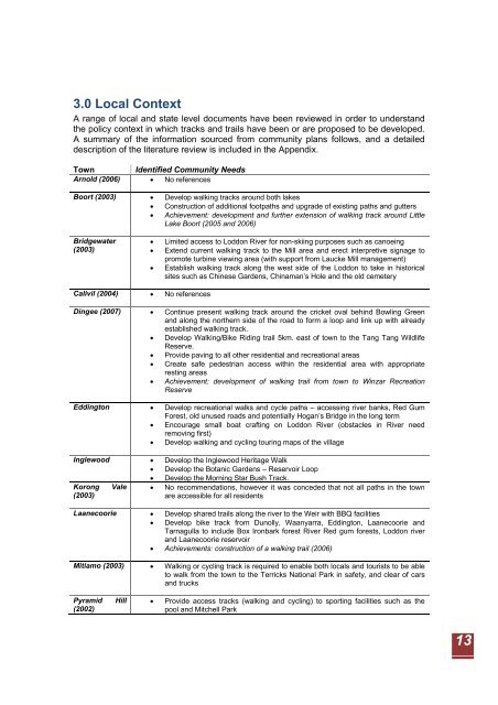
Town Identified Community Needs<br />
Arnold (2006) • No references<br />
Boort (2003) • Develop walking tracks around both lakes<br />
• Construction of additional footpaths <strong>and</strong> upgrade of existing paths <strong>and</strong> gutters<br />
• Achievement: development <strong>and</strong> further extension of walking track around Little<br />
Lake Boort (2005 <strong>and</strong> 2006)<br />
Bridgewater<br />
(2003)<br />
Calivil (2004) • No references<br />
• Limited access to <strong>Loddon</strong> River for non-skiing purposes such as canoeing<br />
• Extend current walking track to the Mill area <strong>and</strong> erect interpretive signage to<br />
promote turbine viewing area (with support from Laucke Mill management)<br />
• Establish walking track along the west side of the <strong>Loddon</strong> to take in historical<br />
sites such as Chinese Gardens, Chinaman’s Hole <strong>and</strong> the old cemetery<br />
Dingee (2007) • Continue present walking track around the cricket oval behind Bowling Green<br />
<strong>and</strong> along the northern side of the road to form a loop <strong>and</strong> link up with already<br />
established walking track.<br />
• Develop Walking/Bike Riding trail 5km. east of town to the Tang Tang Wildlife<br />
Reserve.<br />
• Provide paving to all other residential <strong>and</strong> recreational areas<br />
• Create safe pedestrian access within the residential area with appropriate<br />
resting areas<br />
• Achievement: development of walking trail from town to Winzar Recreation<br />
Reserve<br />
Eddington • Develop recreational walks <strong>and</strong> cycle paths – accessing river banks, Red Gum<br />
Forest, old unused roads <strong>and</strong> potentially Hogan’s Bridge in the long term<br />
• Encourage small boat crafting on <strong>Loddon</strong> River (obstacles in River need<br />
removing first)<br />
• Develop walking <strong>and</strong> cycling touring maps of the village<br />
Inglewood • Develop the Inglewood Heritage Walk<br />
• Develop the Botanic Gardens – Reservoir Loop<br />
Korong Vale<br />
(2003)<br />
• Develop the Morning Star Bush Track.<br />
• No recommendations, however it was conceded that not all paths in the town<br />
are accessible for all residents<br />
Laanecoorie • Develop shared trails along the river to the Weir with BBQ facilities<br />
• Develop bike track from Dunolly, Waanyarra, Eddington, Laanecoorie <strong>and</strong><br />
Tarnagulla to include Box Ironbark forest River Red gum forests, <strong>Loddon</strong> river<br />
<strong>and</strong> Laanecoorie reservoir<br />
• Achievements: construction of a walking trail (2006)<br />
Mitiamo (2003) • Walking or cycling track is required to enable both locals <strong>and</strong> tourists to be able<br />
to walk from the town to the Terricks National Park in safety, <strong>and</strong> clear of cars<br />
<strong>and</strong> trucks<br />
Pyramid Hill<br />
(2002)<br />
• Provide access tracks (walking <strong>and</strong> cycling) to sporting facilities such as the<br />
pool <strong>and</strong> Mitchell Park<br />
13