

Loddon Tracks and Trails Strategy - Loddon Shire Council
Loddon Tracks and Trails Strategy - Loddon Shire Council
Loddon Tracks and Trails Strategy - Loddon Shire Council

You also want an ePaper? Increase the reach of your titles
YUMPU automatically turns print PDFs into web optimized ePapers that Google loves.
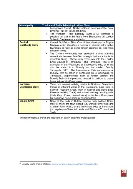
Municipality <strong>Tracks</strong> <strong>and</strong> <strong>Trails</strong> Adjoining <strong>Loddon</strong> <strong>Shire</strong><br />
Leanganook Track). Neither of these sections of the Great<br />
Dividing Trail link to <strong>Loddon</strong> <strong>Shire</strong>.<br />
• The Victorian <strong>Trails</strong> <strong>Strategy</strong> (2005-2010) identifies a<br />
possible rail trail in the future from Shelbourne (in <strong>Loddon</strong><br />
Central<br />
Goldfields <strong>Shire</strong><br />
Northern<br />
Grampians <strong>Shire</strong><br />
<strong>Shire</strong>) to Castlemaine via Maldon.<br />
• Central Goldfields <strong>Shire</strong> <strong>Council</strong> has developed a Bicycle<br />
<strong>Strategy</strong> which identifies a number of shared paths within<br />
townships as well as some longer distance on road trails<br />
between towns.<br />
• The Dunolly community has produced a map outlining<br />
seven trails between 14-47km in length that are suitable for<br />
mountain biking. These trails cross over into the <strong>Loddon</strong><br />
<strong>Shire</strong> <strong>Council</strong> at Tarnagulla. The Tarnagulla Ride is an<br />
extension of the Waanyarra or Laanecoorie ride, or in fact<br />
can be stated from Dunolly on the sealed Dunolly<br />
Tarnagulla Rd 26 . The Laanecoorie Ride commences at<br />
Dunolly, with an option of continuing on to Waanyarra to<br />
Tarnagulla. Opportunities exist to further connect the<br />
Dunolly <strong>Trails</strong> to the proposed network in <strong>Loddon</strong>, to create<br />
linear trails of significant value.<br />
• There are several walking tracks in Northern Grampians<br />
(range of different walks in the Grampians, Lake Cato in<br />
Stawell, Pleasant Creek Walk in Stawell <strong>and</strong> Deep Lead<br />
Reserve Walking Track) <strong>and</strong> shared walking / cycling trails<br />
(Halls Gap off road shared track) in Northern Grampians,<br />
but no known horse riding or canoeing trails<br />
Buloke <strong>Shire</strong> • None of the trails in Buloke connect with <strong>Loddon</strong> <strong>Shire</strong>.<br />
Most of them are town based (i.e. Donald town walk <strong>and</strong><br />
Charlton River Walk), or are fairly short loops or linear trails<br />
(i.e. Wycheproof Mountain Walk <strong>and</strong> Birchip to Tchum Lake<br />
Trail).<br />
The following map shows the locations of trail in adjoining municipalities.<br />
26 Dunolly Cycle <strong>Tracks</strong> Website: http://www.imagelink.com.au/Cycle/Tarnagulla.htm<br />
25