

Loddon Tracks and Trails Strategy - Loddon Shire Council
Loddon Tracks and Trails Strategy - Loddon Shire Council
Loddon Tracks and Trails Strategy - Loddon Shire Council

Create successful ePaper yourself
Turn your PDF publications into a flip-book with our unique Google optimized e-Paper software.
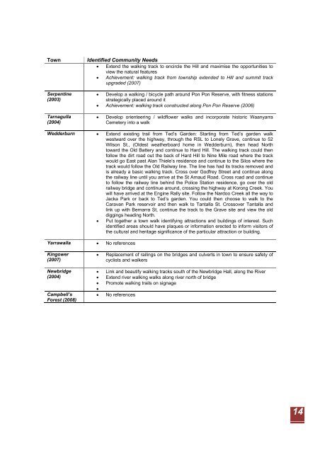
Town Identified Community Needs<br />
• Extend the walking track to encircle the Hill <strong>and</strong> maximise the opportunities to<br />
view the natural features<br />
• Achievement: walking track from township extended to Hill <strong>and</strong> summit track<br />
upgraded (2007)<br />
Serpentine<br />
(2003)<br />
Tarnagulla<br />
(2004)<br />
• Develop a walking / bicycle path around Pon Pon Reserve, with fitness stations<br />
strategically placed around it<br />
• Achievement: walking track constructed along Pon Pon Reserve (2006)<br />
• Develop orienteering / wildflower walks <strong>and</strong> incorporate historic Waanyarra<br />
Cemetery into a walk<br />
Wedderburn • Extend existing trail from Ted’s Garden: Starting from Ted’s garden walk<br />
westward over the highway, through the RSL to Lonely Grave, continue to 52<br />
Wilson St., (Oldest weatherboard home in Wedderburn), then head North<br />
toward the Old Battery <strong>and</strong> continue to Hard Hill. The walking track could then<br />
follow the dirt road out the back of Hard Hill to Nine Mile road where the track<br />
would go East past Alan Thiele’s residence <strong>and</strong> continue to the Silos where the<br />
track would follow the Old Railway line. The line has had its tracks removed <strong>and</strong><br />
is already a basic walking track. Cross over Godfrey Street <strong>and</strong> continue along<br />
the railway line until you arrive at the St Arnaud Road. Cross road <strong>and</strong> continue<br />
to follow the railway line behind the Police Station residence, go over the old<br />
railway bridge <strong>and</strong> continue around, crossing the highway at Korong Creek. You<br />
will have arrived at the Engine Rally site. Follow the Nardoo Creek all the way to<br />
Jacka Park or back to Ted’s garden. You could then choose to walk to the<br />
Caravan Park reservoir <strong>and</strong> then walk to Tantalla St. Crossover Tantalla <strong>and</strong><br />
link up with Bernarra St, continue the track to the Grave site <strong>and</strong> view the old<br />
diggings heading North.<br />
• Put together a town walk identifying attractions <strong>and</strong> buildings of interest. Such<br />
identified areas should have plaques or information erected to inform visitors of<br />
the cultural <strong>and</strong> heritage significance of the particular attraction or building.<br />
Yarrawalla • No references<br />
Kingower<br />
(2007)<br />
Newbridge<br />
(2004)<br />
Campbell’s<br />
Forest (2008)<br />
• Replacement of railings on the bridges <strong>and</strong> culverts in town to ensure safety of<br />
cyclists <strong>and</strong> walkers<br />
• Link <strong>and</strong> beautify walking tracks south of the Newbridge Hall, along the River<br />
• Extend river walking walks along river north of bridge<br />
• Promote walking trails on signage<br />
•<br />
• No references<br />
14