MILTON INTENSIFICATION AND INFILL STUDY - Town of Milton
MILTON INTENSIFICATION AND INFILL STUDY - Town of Milton
MILTON INTENSIFICATION AND INFILL STUDY - Town of Milton

Create successful ePaper yourself
Turn your PDF publications into a flip-book with our unique Google optimized e-Paper software.
<strong>MILTON</strong><br />
<strong>INTENSIFICATION</strong><br />
<strong>AND</strong> <strong>INFILL</strong> <strong>STUDY</strong><br />
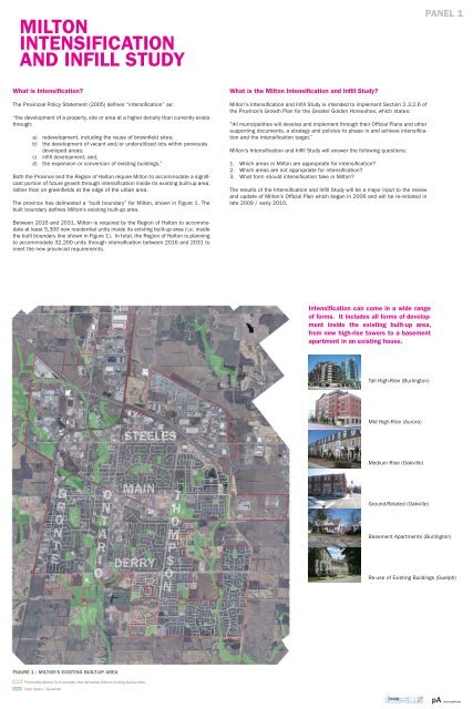
What is Intensification?<br />
The Provincial Policy Statement (2005) defines “intensification” as:<br />
“the development <strong>of</strong> a property, site or area at a higher density than currently exists<br />
through:<br />
a) redevelopment, including the reuse <strong>of</strong> brownfield sites;<br />
b) the development <strong>of</strong> vacant and/or underutilized lots within previously<br />
developed areas;<br />
c) infill development; and,<br />
d) the expansion or conversion <strong>of</strong> existing buildings.”<br />
Both the Province and the Region <strong>of</strong> Halton require <strong>Milton</strong> to accommodate a significant<br />
portion <strong>of</strong> future growth through intensification inside its existing built-up area,<br />
rather than on greenfields at the edge <strong>of</strong> the urban area.<br />
The province has delineated a “built boundary” for <strong>Milton</strong>, shown in Figure 1. The<br />
built boundary defines <strong>Milton</strong>’s existing built-up area.<br />
Between 2016 and 2031, <strong>Milton</strong> is required by the Region <strong>of</strong> Halton to accommodate<br />
at least 5,300 new residential units inside its existing built-up area (i.e. inside<br />
the built boundary line shown in Figure 1). In total, the Region <strong>of</strong> Halton is planning<br />
to accommodate 32,200 units through intensification between 2016 and 2031 to<br />
meet the new provincial requirements.<br />
T<br />
EEEEEEEEEEEEEEEEEEEE<br />
BBBBBBBBBBBBBB RONNNNNNNNNNNNNNNNNN<br />
OOOOOOOOOOO<br />
NNNNNNNNNNNNNN T<br />
AAAAAAAAAAAAAAAAAAAA<br />
RRRRRRRRRRRRRRRRR<br />
I<br />
OOOOOOOOOOOOOOOOOOO<br />
FIGURE 1 : <strong>MILTON</strong>’S EXISTING BUILT-UP AREA<br />
Provincially-defined built boundary that delineates <strong>Milton</strong>’s existing built-up area<br />
Open Space / Greenbelt<br />
STEELES<br />
MAIN<br />
DERRY<br />
TTTTTTTTTTTTT<br />
H<br />
OOOOOOOOOOOOOOOOOO<br />
M PSSSSSSSSSSSSSOOOOOOOOOOOOOOO<br />
NNNNNNNNNNNNNNN<br />
What is the <strong>Milton</strong> Intensification and Infill Study?<br />
<strong>Milton</strong>'s Intensification and Infill Study is intended to implement Section 2.3.2.6 <strong>of</strong><br />
the Province’s Growth Plan for the Greater Golden Horseshoe, which states:<br />
"All municipalities will develop and implement through their Official Plans and other<br />
supporting documents, a strategy and policies to phase in and achieve intensification<br />
and the intensification target.”<br />
<strong>Milton</strong>’s Intensification and Infill Study will answer the following questions:<br />
1. Which areas in <strong>Milton</strong> are appropriate for intensification?<br />
2. Which areas are not appropriate for intensification?<br />
3. What form should intensification take in <strong>Milton</strong>?<br />
The results <strong>of</strong> the Intensification and Infill Study will be a major input to the review<br />
and update <strong>of</strong> <strong>Milton</strong>’s Official Plan which began in 2006 and will be re-initiated in<br />
late 2009 / early 2010.<br />
Intensification can come in a wide range<br />
<strong>of</strong> forms. It includes all forms <strong>of</strong> development<br />
inside the existing built-up area,<br />
from new high-rise towers to a basement<br />
apartment in an existing house.<br />
Tall High-Rise (Burlington)<br />
Mid High-Rise (Aurora)<br />
Medium Rise (Oakville)<br />
Ground-Related (Oakville)<br />
PANEL 1<br />
Basement Apartments (Burlington)<br />
Re-use <strong>of</strong> Existing Buildings (Guelph)<br />
pA planningAlliance
Figure 2: Urban Growth Centres in the Greater Golden Horseshoe<br />
(Source: Places to Grow Growth Plan for the Greater Golden Horseshoe, Ministry<br />
<strong>of</strong> Energy and Infrastructure, 2006)<br />
Figure 3: Approximate Size and Scale <strong>of</strong> the Downtown <strong>Milton</strong> Urban Growth<br />
Centre as Defined by the Province<br />
(Source: Size and Location <strong>of</strong> Urban Growth Centres in the Greater Golden<br />
Horseshoe, Ministry <strong>of</strong> Energy and Infrastructure, 2008)<br />
DOWNTOWN <strong>MILTON</strong><br />
URBAN GROWTH<br />
CENTRE<br />
What is an Urban Growth Centre?<br />
Martin St<br />
Fulton St<br />
Oak Street<br />
Ontario Street<br />
Main Street<br />
Figure 4: Downtown <strong>Milton</strong> Urban Growth Centre<br />
Nipissing Road<br />
Thompson Road<br />
PANEL 2<br />
Ontario’s Growth Plan for the Greater Golden Horseshoe identifies 25 locations across the<br />
region as Urban Growth Centres (UGCs) (see Figure 2). Downtown <strong>Milton</strong> is identified as<br />
one <strong>of</strong> these UGCs.<br />
UGCs are defined in the Growth Plan as areas that will be planned:<br />
a) as focal areas for investment in institutional and region-wide public services, as well<br />
as commercial, recreational, cultural and entertainment uses;<br />
b) to accommodate and support major transit infrastructure;<br />
c) to serve as high density major employment centres that will attract provincially,<br />
nationally or internationally significant employment uses; and<br />
d) to accommodate a significant share <strong>of</strong> population and employment growth.<br />
The Growth Plan also establishes minimum density requirements for each UGC. The Province<br />
requires the Downtown <strong>Milton</strong> UGC to be planned to achieve a minimum density <strong>of</strong><br />
200 people and jobs combined per hectare by 2031. This translates into a total <strong>of</strong><br />
27,360 people and jobs combined in the UGC by 2031.<br />
Where is <strong>Milton</strong>’s Urban Growth Centre?<br />
The Province has provided an approximate size and scale for the Downtown <strong>Milton</strong> UGC,<br />
shown in Figure 3.<br />
The <strong>Town</strong> <strong>of</strong> <strong>Milton</strong> has identified more detailed boundaries for its UGC, shown in Figure 4.<br />
The UGC covers 136.8 hectares, stretching approximately from Martin Street in the west<br />
to Thompson Road in the east, and from just north <strong>of</strong> Main Street in the north, to Nipissing<br />
Road in the south. This is the area to which the Province’s minimum density target <strong>of</strong> 200<br />
people and jobs combined per hectare applies.<br />
Given the minimum density requirements <strong>of</strong> the Province’s<br />
Growth Plan for the Greater Golden Horseshoe, the <strong>Town</strong> <strong>of</strong><br />
<strong>Milton</strong> must plan to accommodate at least 27,360 people<br />
and jobs combined inside its Urban Growth Centre by<br />
2031. Currently, the UGC has approximately 7,300 people<br />
and jobs.<br />
pA planningAlliance
PUBLIC WORKSHOP #1<br />
Background<br />
On June 24, 2009 the <strong>Town</strong> hosted a public workshop to seek input on the development<br />
<strong>of</strong> the Intensification and Infill Study.<br />
Participants were asked to respond to the following questions:<br />
1) What benefits do you think or hope intensification will bring to <strong>Milton</strong>? What is it about<br />
intensification that most concerns you?<br />
2) What do you see as the factors or characteristics that make an area appropriate or<br />
inappropriate for intensification?<br />
3) What locations in <strong>Milton</strong> would be appropriate for ground-related, medium-rise, mid<br />
high-rise and tall high-rise forms <strong>of</strong> intensification?<br />
The following provides a summary <strong>of</strong> the main themes that were expressed at the workshop.<br />
It is important to note that this summary is not intended to represent a consensus<br />
view, nor is it intended to capture every individual comment. Its intent is to indicate the<br />
broad themes that emerged from the workshop.<br />
Potential Benefits <strong>of</strong> Intensification:<br />
• bring positive economic growth and increase the <strong>Town</strong>’s tax base<br />
• provide a larger customer base for local businesses<br />
• improve areas <strong>of</strong> <strong>Milton</strong> that are currently underused or in need <strong>of</strong> revitalization,<br />
such as brownfields<br />
• create a livelier downtown with more cultural amenities and more people on the street<br />
• improve local transportation infrastructure, particularly transit<br />
• slow urban sprawl onto green spaces and farmlands<br />
• bring new businesses and people into the <strong>Town</strong> and increase diversity<br />
Concerns About Intensification:<br />
PANEL 3<br />
• pressure on existing infrastructure and servicing, particularly roads<br />
• ability <strong>of</strong> the current water system in Old <strong>Milton</strong> to handle new growth<br />
• negative impacts on <strong>Milton</strong>’s heritage, distinct identity and small town feel<br />
• loss <strong>of</strong> green space<br />
• impacts on views <strong>of</strong> the escarpment<br />
• impacts from tall buildings on low-density housing, such as loss <strong>of</strong> privacy<br />
and shadowing<br />
• potential for increases in criminal activity<br />
• potential impacts on property values<br />
Appropriate Areas for Intensification:<br />
• areas where there is the potential to revitalize underused lands (e.g. vacant lots<br />
and brownfields)<br />
• areas that have existing access to transit service, particularly GO transit<br />
• areas near existing amenities such as schools, shopping sites, parks and hospitals<br />
• areas that need more commercial space<br />
Inappropriate Areas for Intensification<br />
• areas near existing low-density housing<br />
• areas that have high heritage value<br />
• green spaces such as the fairgrounds<br />
• areas that currently have insufficient servicing, particularly traffic problems<br />
• floodplains<br />
Appropriate Forms <strong>of</strong> Intensification<br />
For the final workshop exercise, participants were asked to indicate on a map <strong>of</strong> the<br />
<strong>Town</strong>’s existing built-up area the locations that may be appropriate for the following<br />
forms <strong>of</strong> intensification:<br />
• tall high-rise (predominantly 12 or more storeys in height)<br />
• mid high-rise (predominantly 5-11 storeys in height)<br />
• medium rise (predominantly 3-4 storeys in height)<br />
• ground-related forms <strong>of</strong> intensification (predominantly 1-2 storeys in height)<br />
A conceptual illustration <strong>of</strong> the combined feedback <strong>of</strong> the groups is shown in Figure 5.<br />
Figure 5 : Consolidated Comments on Potential Intensification Areas from Public Workshop #1, June 24, 2009<br />
(Note: This map is an overlay <strong>of</strong> comments received at the workshop. It is not intended to illustrate a consensus or majority view).<br />
pA planningAlliance
<strong>INTENSIFICATION</strong> IN <strong>MILTON</strong>’S<br />
URBAN GROWTH CENTRE<br />
Existing Conditions<br />
Current Land Use and Development Pattern<br />
The dominant land use in the Downtown <strong>Milton</strong> Urban Growth Centre is single-storey commercial<br />
uses. The <strong>Milton</strong> Mall is the largest retail area, but major retail uses also exist<br />
next to the GO station. The dominant use in the central part <strong>of</strong> the UGC is the <strong>Milton</strong> GO<br />
station and its associated parking lot. North <strong>of</strong> the GO station are a series <strong>of</strong> industrial<br />
condominiums housing a number <strong>of</strong> service commercial uses and auto-related uses. A<br />
mix <strong>of</strong> <strong>of</strong>fice and service commercial uses also exist along Nipissing Road south <strong>of</strong> the<br />
GO station.<br />
At the south end <strong>of</strong> the UGC boundary, south <strong>of</strong> the mall site, lies the Region <strong>of</strong> Halton’s<br />
Allendale property that includes a senior’s residence and various regional services.<br />
Residential uses are limited in the UGC, and consist primarily <strong>of</strong> low density housing<br />
southwest and northwest <strong>of</strong> Ontario and Main Streets.<br />
Park space is completely absent from the UGC, although recreational uses and the proposed<br />
arts and entertainment complex lie at the eastern boundary along Thompson<br />
Road.<br />
Current Policy Permissions<br />
The current <strong>Milton</strong> Official Plan (OP) was adopted in 1997. This pre-dates the province’s<br />
2006 Growth Plan that identifies the Downtown <strong>Milton</strong> Urban Growth Centre, so the OP<br />
does not specifically identify the Urban Growth Centre as an intensification area, or establish<br />
any density requirements for it. However the area that is now identified as the Urban<br />
Growth Centre lies mostly within the current OPs Central Business District Secondary<br />
Plan Area. This area currently permits building heights ranging from 4 to 7 storeys and<br />
allows for a variety <strong>of</strong> land uses including residential, commercial and mixed use.<br />
Figure 6 shows the current OP’s height limits. These maximum heights would provide for<br />
development that would accommodate approximately 170 people and jobs combined per<br />
hectare, less than the 200 people and jobs combined per hectare now required by the<br />
province’s Growth Plan. In addition, the current land use permissions <strong>of</strong> the OP, which include<br />
large areas for commercial development, would fail to yield the 5,300 residential intensification<br />
units required by the Region <strong>of</strong> Halton. As a result, if the current OP is unchanged,<br />
additional intensification would have to be distributed elsewhere in the <strong>Town</strong>.<br />
Figure 6: Current <strong>Milton</strong> Official Plan Central Business District Secondary Plan Height Limits<br />
PANEL 4<br />
Factors to Consider in Developing an Intensification Vision for the Urban<br />
Growth Centre<br />
Legislative Requirements:<br />
• Province’s minimum density requirement <strong>of</strong> 200 people and jobs per hectare.<br />
• Accommodating a significant portion <strong>of</strong> the 5,300 intensification units required by<br />
Halton Region in order to reduce intensification pressures elsewhere in the <strong>Town</strong>.<br />
Physical Attributes:<br />
• Destiny <strong>Milton</strong> 2 seeks to make the CBD the main focal point – administrative,<br />
cultural, entertainment, commercial, social and historic – <strong>of</strong> the community.<br />
• Several large parcels that provide significant opportunities for future redevelopment.<br />
• The GO station is a major trip generator and presents an opportunity to shift a<br />
significant proportion <strong>of</strong> trips from private automobiles to public transit.<br />
• The low density and car-dependent nature <strong>of</strong> existing commercial development and<br />
amount <strong>of</strong> land devoted to surface parking.<br />
• Destiny <strong>Milton</strong> 2 directs higher density development to arterial roads and transit<br />
corridors; Main Street, Ontario Street and Thompson Road bisect the UGC.<br />
• The function <strong>of</strong> Main Street as the main east - west arterial road leading to a<br />
significant new business park now being planned to the east <strong>of</strong> James Snow Parkway.<br />
• Recent age <strong>of</strong> many <strong>of</strong> the commercial uses at the southwest corner <strong>of</strong> Main and<br />
Thompson, and resulting reduced likelihood <strong>of</strong> redevelopment in the near term.<br />
Alternatively, the age <strong>of</strong> the <strong>Milton</strong> Mall means that redevelopment potential is<br />
greater in the short term.<br />
• Need for new residential development to support local stores and businesses.<br />
• Preservation <strong>of</strong> views <strong>of</strong> the Niagara Escarpment<br />
Physical Constraints:<br />
• Proximity to low-density residential neighbourhoods at the edges <strong>of</strong> the UGC.<br />
• Lack <strong>of</strong> park space.<br />
• Water and wastewater servicing constraints.<br />
• Poor connections between the UGC and the historic town centre along the western<br />
part <strong>of</strong> Main Street.<br />
• Traffic congestion is already significant along Main and Ontario Streets and there are<br />
limited alternatives for east-west and north-south travel movements.<br />
• The fragmented nature <strong>of</strong> the ownership <strong>of</strong> the multi-unit buildings on the north side<br />
<strong>of</strong> Main (multiple Plans <strong>of</strong> Condominium).<br />
The current <strong>Milton</strong> Official Plan allows for a density<br />
<strong>of</strong> approximately 170 people and jobs combined<br />
per hectare, not enough to meet the density<br />
requirements <strong>of</strong> the Province’s Growth Plan.<br />
pA planningAlliance
Potential Long-Term Growth<br />
Scenario for the UGC<br />
(25 years and beyond)<br />
8 storey<br />
Figure 7: Theoretical view looking north from the GO station toward<br />
Main Street, 25 years from now.<br />
8 storey<br />
10 storey<br />
Figure 8: Theoretical view looking west along Main Street from Thompson Road, 25<br />
years from now.<br />
Figure 9: Recommended Density Permissions for the Urban Growth Centre (overall<br />
density up to 250 people and jobs per hectare over 25+ years).<br />
Urban Growth Centre Boundary<br />
Conceptual Open Space Network<br />
1 - 2 Storeys<br />
2<br />
3 - 4 Storeys<br />
6 - 8 Storeys<br />
10 - 14 Storeys<br />
<strong>INTENSIFICATION</strong> IN<br />
<strong>MILTON</strong>’S URBAN<br />
GROWTH CENTRE<br />
(cont’d)<br />
Potential Elements <strong>of</strong> an Intensification Vision for the Urban<br />
Growth Centre<br />
The following elements <strong>of</strong> an Intensification Vision for the UGC build upon the<br />
directions <strong>of</strong> Destiny <strong>Milton</strong> 2:<br />
Figure 10: Theoretical rendering illustrating the transition between the UGC and existing low density residential neighbourhoods.<br />
3<br />
4<br />
• Maintain, promote and enhance the UGC as one <strong>of</strong> the primary focal points<br />
for commerce, tourism and pedestrian-scale activity in the <strong>Town</strong>.<br />
• Encourage the development <strong>of</strong> a range <strong>of</strong> uses that will support the UGC as<br />
a place to live, work and play.<br />
• Higher density, high quality employment uses, such as <strong>of</strong>fice buildings, that<br />
take advantage <strong>of</strong> the GO station access.<br />
• Create a sense <strong>of</strong> civic identity and pride through a high standard <strong>of</strong><br />
urban design.<br />
• A model <strong>of</strong> environmental sustainability, including buildings that meet the<br />
highest standards <strong>of</strong> energy and water use efficiency.<br />
• Provide a full range <strong>of</strong> housing opportunities for present and future residents<br />
<strong>of</strong> all ages and incomes.<br />
• Carefully integrate new development into the fabric <strong>of</strong> the existing community,<br />
through context sensitive urban design. Minimize the impacts <strong>of</strong> new<br />
development on adjacent low-density residential neighbourhoods through<br />
the use <strong>of</strong> reduced heights and staggered setbacks.<br />
• Ensure that there is a strong relationship between new development and the<br />
street and that new development is supported by improvements to the public<br />
realm.<br />
• Enhance the eastern edge <strong>of</strong> the UGC as a gateway to the <strong>Town</strong> that<br />
demonstrates civic pride and creates a sense <strong>of</strong> arrival in the heart <strong>of</strong> <strong>Milton</strong>.<br />
• Encourage and facilitate pedestrian and bicycle traffic through the use <strong>of</strong><br />
trails, paths and lanes.<br />
• Introduce new park space into the UGC.<br />
• A pedestrian, cycling and transit-first community, where dependence on the<br />
private automobile is minimized. Fully integrate the GO station into<br />
surrounding neighbourhoods by providing quick and easy access,<br />
particularly by pedestrians, cyclists and local transit.<br />
5<br />
8<br />
PANEL 5<br />
pA planningAlliance
Existing Conditions<br />
Bronte Street South<br />
Main Street<br />
Figure 11: Potential sites for intensification in <strong>Milton</strong>’s historic core<br />
Figure 12: Preservation <strong>of</strong> Escarpment views is a key element <strong>of</strong> the Intensification<br />
Vision for the historic core <strong>of</strong> <strong>Milton</strong>. This image shows how a 4-storey built form on<br />
both sides <strong>of</strong> Main Street would still allow for views <strong>of</strong> the Escarpment, as well as a<br />
skyline dominated by the church steeples.<br />
Figure 13: Theoretical rendering illustrating how a potential development scheme<br />
could integrate with its historic setting (note: this is not an actual development proposal).<br />
<strong>INTENSIFICATION</strong> IN<br />
<strong>MILTON</strong>’S HISTORIC<br />
CORE<br />
Current Land Use and Development Pattern<br />
<strong>Milton</strong>’s historic core includes a wide range <strong>of</strong> residential, retail and employment uses.<br />
PANEL 6<br />
Buildings generally range in height from 1 to 3 storeys and many are <strong>of</strong> historic significance.<br />
The most significant cultural heritage landscape in the <strong>Town</strong> <strong>of</strong> <strong>Milton</strong> is the Courthouse<br />
Square. This four-acre space includes Victoria Park on the west <strong>of</strong> Brown Street<br />
and, to its east, a complex <strong>of</strong> heritage buildings comprising the former Halton Court<br />
House and Jail and former Registry Office and their associated open spaces.<br />
The urban form is pedestrian-oriented, with wide sidewalks, pedestrian amenities such as<br />
benches and landscaping, and buildings generally set close to the street.<br />
Lands to the north and south <strong>of</strong> Main Street are dominated by low density housing, many<br />
<strong>of</strong> which are <strong>of</strong> historical significance.<br />
Mill Pond functions as a major park and amenity, drawing visitors from across the <strong>Town</strong>.<br />
Intensification potential in the historic core is limited. Parcels are generally small,<br />
and the proximity <strong>of</strong> low density housing and the historic 1-3 storey buildings limit opportunities<br />
for higher density development.<br />
The floodplain <strong>of</strong> the Sixteen Mile Creek also bisects the historic core, limiting opportunities<br />
for redevelopment.<br />
Factors to Consider in Developing an Intensification Vision for <strong>Milton</strong>’s<br />
Historic Core<br />
• One <strong>of</strong> the goals <strong>of</strong> Destiny <strong>Milton</strong> 2 is to make the Central Business District the main<br />
focal point – administrative, cultural, entertainment, commercial, social and historic<br />
– <strong>of</strong> the community.<br />
• Need for new residential development to support local stores and businesses.<br />
• Small and irregular parcel fabric.<br />
• Abundance <strong>of</strong> historically significant buildings.<br />
• Proximity to low density residential areas.<br />
• Maintenance <strong>of</strong> views to the Niagara Escarpment.<br />
• Traffic impacts, particularly along Main Street, and the provision <strong>of</strong> parking.<br />
• Role <strong>of</strong> the historic core in establishing the identity and civic pride <strong>of</strong> <strong>Milton</strong>.<br />
• Location <strong>of</strong> floodplain and its impact on development.<br />
• Relatively few potential intensification parcels (less than 3 hectares in total).<br />
Potential Elements <strong>of</strong> an Intensification Vision for <strong>Milton</strong>’s Historic Core<br />
The following elements <strong>of</strong> an Intensification Vision for <strong>Milton</strong>’s historic core build upon<br />
the directions <strong>of</strong> Destiny <strong>Milton</strong> 2:<br />
• Maintain, promote and enhance the historic core as one <strong>of</strong> the primary focal points<br />
for commerce, tourism and pedestrian-scale activity in the <strong>Town</strong>.<br />
• Protect historic buildings and views to the Niagara Escarpment.<br />
• Encourage the development <strong>of</strong> a range <strong>of</strong> uses that will support the historic core as<br />
a place to live, work and play.<br />
• Create a sense <strong>of</strong> civic identity and pride through a high standard <strong>of</strong> urban design,<br />
public space and public art.<br />
• Provide a full range <strong>of</strong> housing opportunities for present and future residents <strong>of</strong> all<br />
ages and incomes.<br />
• Carefully integrate new development into the fabric <strong>of</strong> the existing community,<br />
through context sensitive urban design. Minimize the impacts <strong>of</strong> new development on<br />
adjacent low-density residential neighbourhoods through the use <strong>of</strong> reduced heights<br />
and staggered setbacks.<br />
• Ensure that there is a strong relationship between new development and the street<br />
and that new development is supported by improvements to the public realm.<br />
• Enhance the western edges <strong>of</strong> the historic core as a gateway that demonstrates civic<br />
pride and creates a sense <strong>of</strong> arrival in the heart <strong>of</strong> <strong>Milton</strong>.<br />
• A pedestrian, cycling and transit-first community, where dependence on the private<br />
automobile is minimized. Encourage and facilitate pedestrian and bicycle traffic<br />
through the use <strong>of</strong> trails, paths and lanes.<br />
pA planningAlliance
<strong>INTENSIFICATION</strong> IN OTHER PARTS OF <strong>MILTON</strong><br />
Background<br />
The Downtown <strong>Milton</strong> Urban Growth Centre will be the primary location for future intensification<br />
in the <strong>Town</strong>. However, limited opportunities do exist elsewhere in the <strong>Town</strong> that<br />
could accommodate some intensification. Sites that currently have large amounts <strong>of</strong> surface<br />
parking, such as plazas and strip malls, and large parcels on arterial roads and transit<br />
corridors may have potential for redevelopment over the next 25 or more years.<br />
In total, 187 hectares <strong>of</strong> potential intensification sites have been identified in multiple locations<br />
across the <strong>Town</strong>, outside <strong>of</strong> the Urban Growth Centre. About 30 percent <strong>of</strong> this<br />
area is currently designated for employment uses, leaving 70 percent, or 144 hectares,<br />
for potential residential and mixed use development.<br />
The majority <strong>of</strong> the potential sites are concentrated along Bronte Street, Ontario Street<br />
and Steeles Avenue, as shown in Figure 14.<br />
Figure 14: Potential Sites for Intensification Outside <strong>of</strong> the Urban Growth Centre<br />
PANEL 7<br />
Potential Elements <strong>of</strong> an Intensification Vision for Other Parts <strong>of</strong> <strong>Milton</strong><br />
• Encourage the development <strong>of</strong> alternative housing forms to provide a broader range<br />
<strong>of</strong> housing along transit corridors.<br />
• Carefully integrate new development into the fabric <strong>of</strong> existing communities, through<br />
context sensitive urban design. Minimize the impacts <strong>of</strong> new development on<br />
adjacent low-density residential neighbourhoods through the use <strong>of</strong> reduced heights<br />
and staggered setbacks.<br />
• Focus density and intensification along arterial roads that <strong>of</strong>fer high levels <strong>of</strong> transit<br />
service.<br />
• A pedestrian, cycling and transit-first community, where dependence on the private<br />
automobile is minimized. Encourage and facilitate pedestrian and bicycle traffic<br />
through the use <strong>of</strong> trails, paths and lanes.<br />
pA planningAlliance
Basic Tower,<br />
45° angular plane<br />
45° angular plane<br />
Podium + Tower stepped back massing<br />
Active “at-grade” retail uses and canopies create a friendlier environment for pedestrians.<br />
Incorporating mid-block walkways and urban plazas into new development provides a pleasant environment for new and<br />
existing residents to access activity centres.<br />
Stepped massings such that taller building do not overwhelm existing lower density buildings<br />
A definable ro<strong>of</strong> edge, that shields ro<strong>of</strong>top mechanical elements, contributes to an appealing skyline and also reduces the<br />
visual impact <strong>of</strong> taller buildings.<br />
Balconies and strong window elements help articulate and<br />
“break-up” the visual impact <strong>of</strong> large-scale buildings.<br />
Unarticulated buildings read as heavy, unappealing volumes.<br />
BUILDING FORM<br />
<strong>AND</strong> HEIGHT<br />
Determining Appropriate Building Form and Height<br />
PANEL 8<br />
Throughout <strong>Milton</strong>, a variety <strong>of</strong> potential sites exist for future intensification. Some locations may be appropriate<br />
for taller buildings, others may be more suitable for mid- or low-rise forms <strong>of</strong> intensification. The<br />
following considerations should apply when determining appropriate building forms and heights in specific<br />
locations.<br />
Protect privacy by minimizing visual intrusion on nearby residents.<br />
• Ensure adequate distance between buildings and <strong>of</strong>fset windows and balconies.<br />
Minimize shadow impacts on adjacent properties.<br />
• Height limits should be set below an angular plane (typically 30 to 40 degrees) that allows for sunlight<br />
penetration to neighbouring properties.<br />
• Towers should be slender and oriented in a north-south direction to minimize shadowing.<br />
Building heights should not overwhelm the street. New development should create a pleasant pedestrian<br />
environment on adjacent streets.<br />
• The height <strong>of</strong> buildings should have a proportional relationship to the street right-<strong>of</strong>-way in order to<br />
create a well-defined character for the street. Towers should be set back on a podium base that<br />
frames the street and creates a well-defined street wall in a consistent manner, creating a pleasant,<br />
lively and pedestrian friendly street frontage.<br />
• No development should shadow the northern sidewalk between 11 am and 4 pm between March 21<br />
and September 21.<br />
• Colonnades, overhangs and/or canopies should be included to shelter pedestrians and control<br />
wind effects.<br />
• Taller buildings should include active retail uses (e.g. shops, restaurants, cafes) along main streets to<br />
contribute to pedestrian activity.<br />
• Along street frontages, orient windows, main entrances and other primary building façade elements<br />
toward the street.<br />
Contribute to the betterment <strong>of</strong> the public realm.<br />
• Buildings should be sited and massed in a manner that creates landscaped courtyards or other open<br />
spaces that are usable by the building’s residents as well as neighbours.<br />
• Improvements to the streetscape, such as s<strong>of</strong>t landscaping, lighting fixtures, benches and public art,<br />
should be part <strong>of</strong> the overall project design.<br />
• Integrate open space and walkway systems with convenient and attractive linkages from<br />
residential areas to other activity areas in the community including schools, parks, commercial centres<br />
and institutions to encourage walking and cycling.<br />
Be respectful and be sensitive to the context and scale <strong>of</strong> neighbouring buildings.<br />
• The mass <strong>of</strong> a new building should step back (down) to provide a transition on sites that are next to,<br />
or across from, existing low rise residential buildings.<br />
• The design <strong>of</strong> new buildings should achieve a complementary design relationship to existing buildings,<br />
while accommodating a diversity <strong>of</strong> architectural styles, building materials and colours, that provide<br />
visual variety and interest.<br />
Ensure adequate parking for the building’s residents in a manner that does not dominate the<br />
streetscape (e.g. utilize rear, side, underground or above-ground parking).<br />
Taller buildings should demonstrate architectural excellence and contribute to a distinctive and<br />
appealing skyline.<br />
• Ro<strong>of</strong>top elements should contribute to the skyline pr<strong>of</strong>ile by having an identifiable, well-detailed,<br />
iconic architectural design.<br />
• Smaller architectural elements and features on the street frontage should be used to create a more<br />
human scale and to “break-up” the visual impact <strong>of</strong> buildings.<br />
• High-grade materials and appropriate colours that achieve an architectural identity while at the same<br />
time remaining respectful <strong>of</strong> their context.<br />
• Buildings should be articulated and fenestrated in a fashion that breaks down large-scale building<br />
mass and avoids large expanses <strong>of</strong> blank walls.<br />
Protect natural features.<br />
• The design <strong>of</strong> sites adjacent to parks, woodlots and watercourses should be sensitive to these<br />
features.<br />
In these instances, appropriate setbacks should be maintained between buildings and sensitive<br />
natural areas, while on-site landscaping should be well integrated with natural areas.<br />
pA planningAlliance