Takaya et al. - 1974 - Rice cultivation and its environmental conditions
Takaya et al. - 1974 - Rice cultivation and its environmental conditions
Takaya et al. - 1974 - Rice cultivation and its environmental conditions

You also want an ePaper? Increase the reach of your titles
YUMPU automatically turns print PDFs into web optimized ePapers that Google loves.
218 Y. TAKAYA, K. KYUMA, <strong>and</strong> K. KAWAGUCI!l<br />
0 10 km<br />
.........._.<br />
~ Rt•claimPd sl'ction<br />
0 Modern dt•lta<br />
Q Jtidl!e sw<strong>al</strong>e compl .. x<br />
0 Ancif'nt dt>lta<br />
0 Water surfact•<br />
An·•a in which rict• J{l'lJWing is common<br />
M Town of Massa Fisca1dia<br />
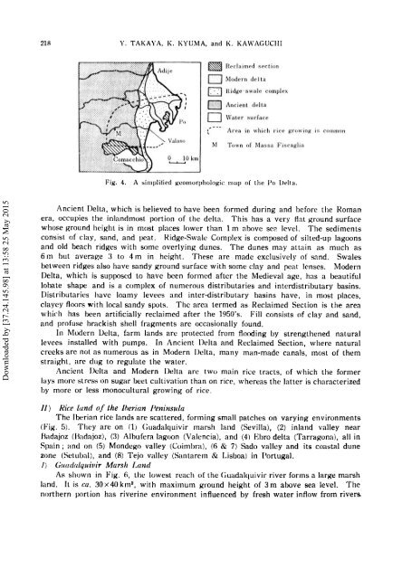
Fig. 4. A simplified l{comorphologic map of the Po Delta.<br />
Downloaded by [37.24.145.98] at 13:58 25 May 2015<br />
Ancient Delta, which is believed to have been formed during <strong>and</strong> before the Roman<br />
era, occupies the inl<strong>and</strong>most portion of the delta. This has a very flat ground surface<br />
whose ground height is in most places lower than 1m above se2 level. The sediments<br />
consist of clay, s<strong>and</strong>, <strong>and</strong> peat. ~idge-Sw<strong>al</strong>e Complex is composed of silted-up lagoons<br />
<strong>and</strong> old beach ridges with some overlying dunes. The dunes may attain as much as<br />
6 m but averag-e :1 to 4 m in height. These are made exclusively of s<strong>and</strong>. Sw<strong>al</strong>es<br />
b<strong>et</strong>ween ridges <strong>al</strong>so have s<strong>and</strong>y ground surface with some clay <strong>and</strong> peat lenses. Modern<br />
Delta, which is supposed to have been formed after the Mediev<strong>al</strong> age, has a beautiful<br />
lobate shape <strong>and</strong> is a complex of numerous distributaries <strong>and</strong> interdistributary basins.<br />
Distributaries have loamy levees <strong>and</strong> inter-distributary basins have, in most places,<br />
clayey floors with loc<strong>al</strong> s<strong>and</strong>y spots. The area termed as Reclaimed Section is the area<br />
which has been artifici<strong>al</strong>ly reclaimed after the 1950's. Fill consists of clay <strong>and</strong> s<strong>and</strong>,<br />
<strong>and</strong> profuse brackish shell fragments are occasion<strong>al</strong>ly found.<br />
In Modern Delta, farm l<strong>and</strong>s arc protected from flooding by strengthened natur<strong>al</strong><br />
levees inst<strong>al</strong>led with pumps. In Ancient Delta <strong>and</strong> Reclaimed Section, where natur<strong>al</strong><br />
creeks are not as numerous as in Modern Delta, many man-made can<strong>al</strong>s, most of them<br />
straight, arc dug to regulate the water.<br />
Ancient Della <strong>and</strong> Modern Delta arc two main rice tracts, of which the former<br />
lays more stress on sugar be<strong>et</strong> <strong>cultivation</strong> than on rice, whereas the latter is characterized<br />
by more or less monocultur<strong>al</strong> growing of rice.<br />
II) <strong>Rice</strong> l<strong>and</strong> of the Jherian Penit~sula<br />
The Iberian rice l<strong>and</strong>s arc scattered, forming sm<strong>al</strong>l patches on varying environments<br />
(Fig. 5). They arc on (1) Cuad<strong>al</strong>quivir marsh l<strong>and</strong> (Sevilla), (2) inl<strong>and</strong> v<strong>al</strong>ley near<br />
Hadajoz (Hadajoz), C:i) Albufcra lagoon (V<strong>al</strong>encia), <strong>and</strong> (4) Ebro delta (Tarragona), <strong>al</strong>l in<br />
Spain; <strong>and</strong> on (5) Mondego v<strong>al</strong>ley (Coimbra), 16 & 7) Sado v<strong>al</strong>ley <strong>and</strong> <strong>its</strong> coast<strong>al</strong> dune<br />
zone (S<strong>et</strong>ub<strong>al</strong>), <strong>and</strong> (8) Tejo v<strong>al</strong>ley (Santarern & Lisboa) in Portug<strong>al</strong>.<br />
/) Guada/quivir Marsh /.<strong>and</strong><br />
As shown in Fig. fi, the lowest reach of the Guad<strong>al</strong>quivir river forms a large marsh<br />
l<strong>and</strong>. ft is ca. 30x40km 2 , with maximum ground height of 3m above sea level. The<br />
northern portion has riverine environment influenced by fresh water inflow from rivers.