Takaya et al. - 1974 - Rice cultivation and its environmental conditions
Takaya et al. - 1974 - Rice cultivation and its environmental conditions
Takaya et al. - 1974 - Rice cultivation and its environmental conditions

You also want an ePaper? Increase the reach of your titles
YUMPU automatically turns print PDFs into web optimized ePapers that Google loves.
220 Y. TAKAYA, K. KYUMA, <strong>and</strong> K. KAWAGUCHI<br />
Downloaded by [37.24.145.98] at 13:58 25 May 2015<br />
2) Inl<strong>and</strong> V<strong>al</strong>ley near Badajoz<br />
This is the only example of rice l<strong>and</strong> situated inl<strong>and</strong> in the Iberian peninsula. The<br />
Guadiana river reve<strong>al</strong>s a braided feature at <strong>its</strong> middle reach when it comes out from<br />
high l<strong>and</strong> of Cambrian rocks to a saucershaped inl<strong>and</strong> basin of Tertiary rocks near<br />
Badajoz. Sever<strong>al</strong> terraces appear <strong>al</strong>ong <strong>its</strong> braided streams. Near stream portions form<br />
narrow strips of <strong>al</strong>luvi<strong>al</strong> plain with the relative height 1 to 3m from the stream bed.<br />
The sediments are composed of fresh gravel with a gray silty to clayey tops<strong>et</strong> bed<br />
sever<strong>al</strong> centim<strong>et</strong>ers thick. Outside this are situated other surfaces having a relative<br />
height 3 to 8 m from the stream bed. These have a yellowish-gray s<strong>and</strong>y top soil <strong>and</strong><br />
somewhat indurated red colored clayey underlay at a depth of sever<strong>al</strong> ten centim<strong>et</strong>ers.<br />
3) Albufera Lagoon<br />
The Albufera lagoon<strong>al</strong> portion is an ov<strong>al</strong> shaped sw<strong>al</strong>e s<strong>and</strong>wiched b<strong>et</strong>ween beach<br />
<strong>and</strong> dunes on the east <strong>and</strong> Quaternary terraces <strong>and</strong> older hills on the west. The silted-up<br />
portion of this lagoon forms a main rice l<strong>and</strong>. Sh<strong>al</strong>low v<strong>al</strong>leys pen<strong>et</strong>rating into<br />
Quaternary terraces, which appear like the arms of the lagoon<strong>al</strong> portion, are another<br />
rice growing area.<br />
The silted-up portion of the lagoon is flat <strong>and</strong> lowlying. This is in most places<br />
lower than 2m above sea level <strong>and</strong> some places are as low as to be protected by polder<br />
banks. Soils are dominantly clay. The pen<strong>et</strong>rating v<strong>al</strong>leys, on the other h<strong>and</strong>, are<br />
gently sloped, rich in coarser materi<strong>al</strong>s including gravels <strong>and</strong> encountered by c<strong>al</strong>careous<br />
bed rocks at relatively sh<strong>al</strong>low depth, though the main portion is still clayey. The<br />
silted-up portion of the lagoon is exclusively utilized for rice growing because of <strong>its</strong><br />
poor drainability. The v<strong>al</strong>ley portion, on the other h<strong>and</strong>, has a mosaic pattern of rice,<br />
veg<strong>et</strong>ables, <strong>and</strong> citrus trees .<br />
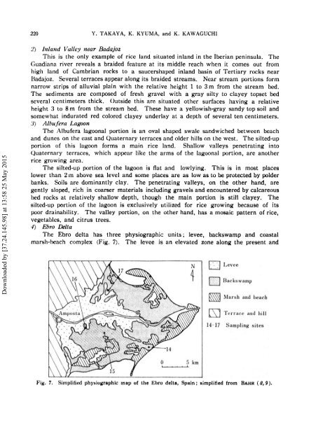
.J) Ebro Della<br />
The Ebro delta has three physiographic un<strong>its</strong>; levee, backswamp <strong>and</strong> coast<strong>al</strong><br />
marsh-beach complex (Fig. 7). The levee is an elevated zone <strong>al</strong>ong the present <strong>and</strong><br />
Q Levee<br />
U Backswamp<br />
~ Marsh <strong>and</strong> beach<br />
(SJ Tt•l'l'nce <strong>and</strong> hill<br />
14·17 Sampling sites<br />
Fig. 7. Simplified physiographic map of the Ebro delta, Spain; simplified from BAHR ( 8, 9 ),