

Iraqi Kurdistan All in the Timing
GEO_ExPro_v12i6
GEO_ExPro_v12i6

You also want an ePaper? Increase the reach of your titles
YUMPU automatically turns print PDFs into web optimized ePapers that Google loves.
GEO Tourism<br />
cont<strong>in</strong>ue to move endlessly around<br />
Antarctica; as this text is fur<strong>the</strong>r drafted<br />
(28 February), we are experienc<strong>in</strong>g a fullblown<br />
gale with driv<strong>in</strong>g snow off Cape<br />
Adare created by <strong>the</strong> latest of <strong>the</strong>se lows.<br />
Once aga<strong>in</strong>, no land<strong>in</strong>gs are possible.<br />
More detail on <strong>the</strong> geology of <strong>the</strong> Ross<br />
Sea may be found <strong>in</strong> <strong>the</strong> memoir and<br />
1:250,000 map that covers <strong>the</strong> Sou<strong>the</strong>rn<br />
Ross Sea, for which ‘Mo’ Turnbull is a<br />
senior author. It is available onl<strong>in</strong>e at<br />
http://www.gns.cri.nz/Home/Products/<br />
Maps with <strong>the</strong> title Geology of Sou<strong>the</strong>rn<br />
Victoria Land, Antarctica.<br />
Neogene Volcanoes<br />
On our trip most planned land<strong>in</strong>gs and<br />
near-shore transits were possible, though<br />
sometimes only after several attempts,<br />
with <strong>the</strong> cloud generally high enough to<br />
savour <strong>the</strong> ‘w<strong>in</strong>ter wonderland’ scenery.<br />
Especially eye-catch<strong>in</strong>g was <strong>the</strong> scale of<br />
<strong>the</strong> Neogene volcanoes <strong>in</strong> and around<br />
Ross Island. The most significant was<br />
Mount Erebus (3,794m), <strong>the</strong> world’s<br />
most sou<strong>the</strong>rly active volcano. It is<br />
dist<strong>in</strong>guished by its permanent, often<br />
boil<strong>in</strong>g lava lake and visually, from afar,<br />
by a white plume associated with near<br />
cont<strong>in</strong>uous Strombolian eruptions. Major<br />
eruptions, however, are currently rare,<br />
with perhaps <strong>the</strong> last one observed by Sir<br />
James Clark Ross <strong>in</strong> 1841 dur<strong>in</strong>g his first<br />
expedition to Antarctica.<br />
Equally spectacular were Mount<br />
Terror and Mount Bird, <strong>the</strong> latter<br />
be<strong>in</strong>g a shield volcano smo<strong>the</strong>red with<br />
ground-hugg<strong>in</strong>g, Christmas-cake-like<br />
layers of ice. <strong>All</strong> three volcanoes carry<br />
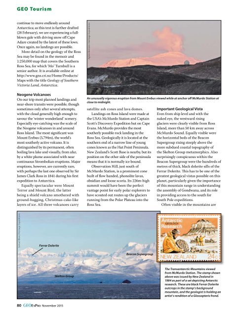
Agnes Breniere /Heritage Expeditions<br />
An unusually vigorous eruption from Mount Erebus viewed while at anchor off McMurdo Station at<br />
close to midnight.<br />
satellite ash cones and lava domes.<br />
Land<strong>in</strong>gs on Ross Island were made at<br />
<strong>the</strong> USA’s McMurdo Station and Capta<strong>in</strong><br />
Scott’s Discovery Expedition hut on Cape<br />
Evans. McMurdo provides <strong>the</strong> most<br />
sou<strong>the</strong>rly possible rock land<strong>in</strong>g <strong>in</strong> <strong>the</strong><br />
Ross Sea. Geologically it is located at <strong>the</strong><br />
sou<strong>the</strong>rn end of a narrow l<strong>in</strong>e of young<br />
cones known as <strong>the</strong> Hut Po<strong>in</strong>t Pen<strong>in</strong>sula.<br />
New Zealand’s Scott Base is nearby, but its<br />
position on <strong>the</strong> o<strong>the</strong>r side of <strong>the</strong> pen<strong>in</strong>sula<br />
means that it is normally ice bound.<br />
Observation Hill, just south of<br />
McMurdo Station, is a prom<strong>in</strong>ent cone<br />
built of flow banded, phonolite lavas,<br />
obsidian and loose scoria. Its 226m-high<br />
summit would have been <strong>the</strong> perfect<br />
vantage po<strong>in</strong>t for early polar explorers to<br />
have scouted out routes up <strong>the</strong> glaciers<br />
runn<strong>in</strong>g from <strong>the</strong> Polar Plateau <strong>in</strong>to <strong>the</strong><br />
Ross Sea.<br />
Important Geological Vista<br />
Even from ship level and with <strong>the</strong><br />
naked eye, <strong>the</strong> westward ris<strong>in</strong>g<br />
glaciers were clearly visible from Ross<br />
Island, more than 50 km away across<br />
McMurdo Sound. Equally visible were<br />
<strong>the</strong> horizontal beds of <strong>the</strong> Beacon<br />
Supergroup ris<strong>in</strong>g steeply above <strong>the</strong><br />
more subdued coastal topography of<br />
<strong>the</strong> Skelton Group metamorphics. Also<br />
surpris<strong>in</strong>gly conspicuous with<strong>in</strong> <strong>the</strong><br />
Beacon Supergroup were <strong>the</strong> hundreds of<br />
metres of thick, black dolerite sills of <strong>the</strong><br />
Ferrar Dolerite. This has to be one of <strong>the</strong><br />
greatest geological vistas possible on this<br />
planet, particularly given <strong>the</strong> importance<br />
of this mounta<strong>in</strong> range <strong>in</strong> understand<strong>in</strong>g<br />
<strong>the</strong> assembly of Gondwana, and its role<br />
<strong>in</strong> provid<strong>in</strong>g access to <strong>the</strong> south for<br />
South Pole expeditions.<br />
Often visible <strong>in</strong> <strong>the</strong> mounta<strong>in</strong>s are<br />
Samuel Blanc/Heritage Expeditions<br />
Ferrar Dolerite<br />
Beacon Supergroup<br />
Skelton Group<br />
The Transantarctic Mounta<strong>in</strong>s viewed<br />
from McMurdo Station. The stamp shown<br />
above was issued by New Zealand <strong>in</strong><br />
1984 as part of a set depict<strong>in</strong>g Antarctic<br />
research. These are black Ferrar Dolerite<br />
outcrops <strong>in</strong> <strong>the</strong> stamp’s background<br />
mounta<strong>in</strong>, and <strong>the</strong> geologist is hold<strong>in</strong>g an<br />
artist’s rendition of a Glossopteris frond.<br />
80 GEOExPro November 2015