2016 Mtns & Mesas with covers

You also want an ePaper? Increase the reach of your titles
YUMPU automatically turns print PDFs into web optimized ePapers that Google loves.
page 14<br />
Mountains & <strong>Mesas</strong><br />
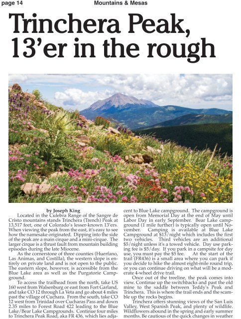
Trinchera Peak,<br />
13’er in the rough<br />
by Joseph King<br />
Located in the Culebra Range of the Sangre de<br />
Cristo mountains stands Trinchera (Trench) Peak at<br />
13,517 feet, one of Colorado’s lesser-known 13’ers.<br />
When viewing the peak from the east, it's easy to see<br />
how the namesake originated. Dipping into the side<br />
of the peak are a main cirque and a mini-cirque. The<br />
larger cirque is a thrust fault from mountain building<br />
episodes during the late Miocene.<br />
As the cornerstone of three counties (Huerfano,<br />
Las Animas, and Costilla), the western slope is entirely<br />
on private land and is not open to the public.<br />
The eastern slope, however, is accessible from the<br />
Blue Lake area as well as the Purgatorie Campground.<br />
To access the trailhead from the north, take US<br />
160 west from Walsenburg or east from Fort Garland,<br />
and take CO 12 through La Veta and go about 4 miles<br />
past the village of Cuchara. From the south, take CO<br />
12 west from Trinidad over Cucharas Pass and down<br />
2.35 miles to Forest Road 422 leading to the Blue<br />
Lake/Bear Lake Campgrounds. Continue four miles<br />
to Trinchera Peak Road, aka FR 436, which lies adjacent<br />
to Blue Lake campground. The campground is<br />
open from Memorial Day at the end of May until<br />
Labor Day in early September. Bear Lake campground<br />
(1 mile further) is typically open until November.<br />
Camping is available at Blue Lake<br />
Campground at $13/night which includes the first<br />
two vehicles. Third vehicles are an additional<br />
$5/night unless it's a towed vehicle. Day use parking<br />
fee is $5/day. If you park in a campsite for day<br />
use, you must pay the $5 fee. At the start of the<br />
trail (FR436) is a small area where you can park if<br />
you decide to hike the almost eight-mile round trip,<br />
or you can continue driving on what will be a moderate<br />
4-wheel drive trail.<br />
Once out of the treeline, the peak comes into<br />
view. Continue up the switchbacks and past the old<br />
mine to the saddle between Teddy's Peak and<br />
Trinchera. This is where the trail ends and the scamble<br />
up the rocks begins.<br />
Trinchera offers stunning views of the San Luis<br />
Valley, West Spanish Peak, and plenty of wildlife.<br />
Wildflowers abound in the spring and early summer<br />
months. Be cautious of the quick changes in weather