

Current Magazine

You also want an ePaper? Increase the reach of your titles
YUMPU automatically turns print PDFs into web optimized ePapers that Google loves.
Feature<br />
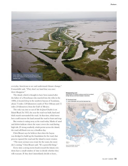
Since 1955, the island has lost 98 percent<br />
of its land. Island Road, pictured, frequently<br />
washes out.<br />
everyday Americans to see and understand climate change,”<br />
Comardelle said. “They don’t see land that was once<br />
there disappear.”<br />
The island, which is thought to have been named after<br />
the father of a Frenchman who married into the tribe in the<br />
1800s, is located deep in the southern bayous of Louisiana,<br />
about 75 miles (120 kilometers) south of New Orleans and 15<br />
miles (24 kilometers) from the Gulf of Mexico.<br />
The only way into or out of Isle de Jean Charles is on<br />
Island Road. In 1953, the year the road was built, land and<br />
thick marsh surrounded the road. At that time, tribal members<br />
could traverse the land around the road to hunt and trap.<br />
But erosion is eating away at the road today. Marks of sand<br />
and debris indicate where the water covers the road during<br />
high tide. If strong southerly winds persist across the island,<br />
the road will flood even on a cloudless day.<br />
Chris Brunet says he believes that when the bayou<br />
was dredged to build up the foundation for the road, that<br />
process exposed the road and the island to more erosion.<br />
“The more avenues you create for the water, the more<br />
she’s coming,” Chris Brunet said. “It’s a powerful thing.”<br />
Every time a strong storm heads toward the island, residents<br />
have a small window of time to decide whether they<br />
will evacuate. If they don’t immediately decide to leave,<br />
FALL 2017 CURRENT 31

