
You also want an ePaper? Increase the reach of your titles
YUMPU automatically turns print PDFs into web optimized ePapers that Google loves.
CASEstudy<br />
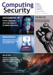
Horizontal cut of the rebars showing accurate comparison<br />
of photogrammetry to terrestrial laser scanning (TLS): blue<br />
circles represent photogrammetry, and red circles represent<br />
TLS; maximum deviation is ~6-10 millimeters<br />
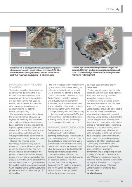
ContextCapture automatically processed images into<br />
accurate 3D mesh models, documenting existing conditions<br />
of London Bridge Station and facilitating decision<br />
making for redevelopment<br />
PHOTOGRAMMETRY VS. LASER<br />
SCANNING<br />
The project provided Costain with an<br />
opportunity to determine the most<br />
efficient, cost-effective method for<br />
surveying and documenting existing<br />
site conditions of the 180-year-old<br />
station, and to deliver accurate 3D<br />
data to accelerate and enhance<br />
decision making for optimal<br />
construction planning.<br />
For years laser scanners have been<br />
the preferred method of capturing<br />
digital data to survey and document<br />
site conditions with precise accuracy.<br />
Laser scanning provides the ability to<br />
capture a point cloud so dense that it's<br />
almost a 3D picture. Points in the scan<br />
are given 3D coordinates and this<br />
virtual geo-referenced representation<br />
can be shared among the design team.<br />
Costain has invested in this<br />
technology to successfully deliver<br />
numerous projects. However, given the<br />
age of the structures they had to 1)<br />
ensure they are clearly visible in the<br />
photos; 2) take pictures from varying<br />
angles and elevations surrounding the<br />
area; 3) survey the GCPs (at least three<br />
are needed to scale and geo-reference<br />
the model); and 4) process photos and<br />
GCPs together using ContextCapture to<br />
produce the final model in a range of<br />
deliverables.<br />
The first two steps can be implemented<br />
by anyone with five minutes training on<br />
determining the best method to mark<br />
GCPs and take the photos to ensure<br />
optimal deliverables. The final step uses<br />
Bentley's reality modeling software,<br />
ContextCapture and is completely<br />
automated, aside from the limited user<br />
time required for uploading the pictures<br />
and identifying the GCPs. While the<br />
overall processing time varies depending<br />
on the number of photos and GCPs, the<br />
entire workflow - from taking the photos,<br />
surveying the GCPs and processing -<br />
can be completed in under an hour.<br />
AUTOMATIC 3D RECONSTRUCTION<br />
Comparing the accuracy of<br />
photogrammetry to that of laser<br />
scanning on the project, Richard Bath, a<br />
graduate surveyor at Costain and user of<br />
ContextCapture, observed there was a<br />
difference of a few milimetres for many<br />
uses on site, such as excavations. And,<br />
while the accuracy of the final 3D reality<br />
mesh predominantly relies on the<br />
comprehensiveness of the photos<br />
acquired, it is not imperative to invest in<br />
an expensive camera. The entire<br />
process, from initial photography<br />
through to the 3D model is automated;<br />
and for the London Bridge Station<br />
reconstruction project, produced<br />
sufficiently accurate results that<br />
optimised costs and other project<br />
deliverables.<br />
Photogrammetry saved time for data<br />
collection and eliminated the bottleneck<br />
associated with sharing a scanner<br />
among two dozen surveyors.<br />
Furthermore, using a camera is much<br />
less expensive than the cost of a laser<br />
scanner. Photogrammetry and<br />
ContextCapture provided a safe, reliable<br />
non-contact survey technique that<br />
streamlined workflows and improved<br />
efficiency. Using Bentley software for the<br />
London Bridge Station reconstruction<br />
saved time and costs while reducing the<br />
chance of misinterpretation, enhancing<br />
reliability and decision making on this<br />
railway redevelopment initiative that,<br />
upon completion in 2018, will transform<br />
travel throughout London and the UK,<br />
expanding through-station passenger<br />
capacity to 90 million people annually.<br />
Concluding, Richard Bath said<br />
"ContextCapture is providing Bentley<br />
users like Costain a software<br />
environment that is progressing the use<br />
of reality 3D capture on a construction<br />
site. With just a smartphone, the entire<br />
workforce has the potential to document<br />
visually-rich 3D construction progress<br />
with a minimal amount of training.<br />
ContextCapture is changing data<br />
capture onsite."<br />
www.bentley.com<br />
May/June 2017 31