MMM Classics Year 10: MMM #s 91-100 - Moon Society
MMM Classics Year 10: MMM #s 91-100 - Moon Society
MMM Classics Year 10: MMM #s 91-100 - Moon Society

Create successful ePaper yourself
Turn your PDF publications into a flip-book with our unique Google optimized e-Paper software.
y Peter Kokh<br />
We are back on the <strong>Moon</strong>, to stay it seems, and we’ve<br />
detected a number of lavatubes from orbit, some handy to our<br />
first beachhead outpost. The catch is that there are so many<br />
things needing priority attention that we cannot afford the<br />
manpower and equipment costs to outfit even a single lavatube<br />
exploration expedition. But if we don’t “go in” and actually<br />
explore and survey, how can we plan intelligently to “move<br />
inside” in concrete particulars?<br />
Here is a way we can survey in detail all the lavatubes<br />
we have detected remotely from photographic evidence, from<br />
orbiting radar and infrared equipment. The costs, in comparison<br />
to a single limited human expedition, would be negligible.<br />
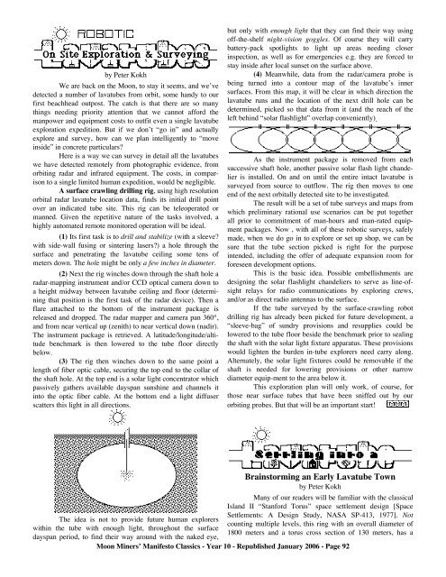
A surface crawling drilling rig, using high resolution<br />
orbital radar lavatube location data, finds its initial drill point<br />
over an indicated tube site. This rig can be teleoperated or<br />
manned. Given the repetitive nature of the tasks involved, a<br />
highly automated remote monitored operation will be ideal.<br />
(1) Its first task is to drill and stabilize (with a sleeve?<br />
with side-wall fusing or sintering lasers?) a hole through the<br />
surface and penetrating the lavatube ceiling some tens of<br />
meters down. The hole might be only a few inches in diameter.<br />
(2) Next the rig winches down through the shaft hole a<br />
radar-mapping instrument and/or CCD optical camera down to<br />
a height midway between lavatube ceiling and floor (determining<br />
that position is the first task of the radar device). Then a<br />
flare attached to the bottom of the instrument package is<br />
released and dropped. The radar mapper and camera pan 360°,<br />
and from near vertical up (zenith) to near vertical down (nadir).<br />
The instrument package is retrieved. A latitude/longitude/altitude<br />
benchmark is then lowered to the tube floor directly<br />
below.<br />
(3) The rig then winches down to the same point a<br />
length of fiber optic cable, securing the top end to the collar of<br />
the shaft hole. At the top end is a solar light concentrator which<br />
passively gathers available dayspan sunshine and channels it<br />
into the optic fiber cable. At the bottom end a light diffuser<br />
scatters this light in all directions.<br />
The idea is not to provide future human explorers<br />
within the tube with enough light, throughout the surface<br />
dayspan period, to find their way around with the naked eye,<br />
but only with enough light that they can find their way using<br />
off-the-shelf night-vision goggles. Of course they will carry<br />
battery-pack spotlights to light up areas needing closer<br />
inspection, as well as for emergencies e.g. they are forced to<br />
stay inside after local sunset on the surface above.<br />
(4) Meanwhile, data from the radar/camera probe is<br />
being turned into a contour map of the lavatube’s inner<br />
surfaces. From this map, it will be clear in which direction the<br />
lavatube runs and the location of the next drill hole can be<br />
determined, picked so that data from it (and the reach of the<br />
left behind “solar flashlight” overlap conveniently).<br />
As the instrument package is removed from each<br />
successive shaft hole, another passive solar flash light chandelier<br />
is installed. On and on until the entire intact lavatube is<br />
surveyed from source to outflow. The rig then moves to one<br />
end of the next orbitally detected site to be investigated.<br />
The result will be a set of tube surveys and maps from<br />
which preliminary rational use scenarios can be put together<br />
all prior to commitment of man-hours and man-rated equipment<br />
packages. Now , with all of these robotic surveys, safely<br />
made, when we do go in to explore or set up shop, we can be<br />
sure that the tube section picked is right for the purpose<br />
intended, including the offer of adequate expansion room for<br />
foreseen development options.<br />
This is the basic idea. Possible embellishments are<br />
designing the solar flashlight chandeliers to serve as line-ofsight<br />
relays for radio communications by exploring crews,<br />
and/or as direct radio antennas to the surface.<br />
If the tube surveyed by the surface-crawling robot<br />
drilling rig has already been picked for future development, a<br />
“sleeve-bag” of sundry provisions and resupplies could be<br />
lowered to the tube floor beside the benchmark prior to sealing<br />
the shaft with the solar light fixture apparatus. These provisions<br />
would lighten the burden in-tube explorers need carry along.<br />
Alternately, the solar light fixtures could be removable if the<br />
shaft is needed for lowering provisions or other narrow<br />
diameter equip-ment to the area below it.<br />
This exploration plan will only work, of course, for<br />
those near surface tubes that have been sniffed out by our<br />
orbiting probes. But that will be an important start!<br />
Brainstorming an Early Lavatube Town<br />
by Peter Kokh<br />
Many of our readers will be familiar with the classical<br />
Island II “Stanford Torus” space settlement design [Space<br />
Settlements: A Design Study, NASA SP-413, 1977]. Not<br />
counting multiple levels, this ring with an overall diameter of<br />
1800 meters and a torus cross section of 130 meters, has a<br />
<strong>Moon</strong> Miners’ Manifesto <strong>Classics</strong> - <strong>Year</strong> <strong>10</strong> - Republished January 2006 - Page 92