Times of the Islands Fall 2018
Presents the "soul of the Turks & Caicos Islands" with in-depth features about local people, culture, history, environment, businesses, resorts, restaurants and activities.
Presents the "soul of the Turks & Caicos Islands" with in-depth features about local people, culture, history, environment, businesses, resorts, restaurants and activities.

Create successful ePaper yourself
Turn your PDF publications into a flip-book with our unique Google optimized e-Paper software.
In <strong>the</strong> wake <strong>of</strong> such a devastating season, many<br />
Islanders will frequently be checking in online with <strong>the</strong><br />
National Hurricane Center, ever cognizant that <strong>the</strong> next<br />
big one might be on <strong>the</strong> way. Many will wonder if <strong>the</strong><br />
<strong>2018</strong> hurricane season will have more challenges in store<br />
for <strong>the</strong> <strong>Islands</strong>. As <strong>of</strong> early September, thankfully, <strong>the</strong> season<br />
has been ra<strong>the</strong>r quiet, with only seven named storms,<br />
all <strong>of</strong> which have had no impact on <strong>the</strong> Turks & Caicos.<br />
Statistically speaking, nearly 80% <strong>of</strong> all tropical<br />
storms and hurricanes in <strong>the</strong> Atlantic Basin occur between<br />
August 15 and about October 20. So this means we<br />
shouldn’t expect hurricanes to form after late October,<br />
right? Unfortunately, no. In order to understand why hurricanes<br />
do continue to form late in <strong>the</strong> season, we must<br />
take a look at some <strong>of</strong> <strong>the</strong> parameters that go into hurricane<br />
formation.<br />
When we are discussing hurricane environment, <strong>the</strong>re<br />
are a number <strong>of</strong> things that meteorologists and o<strong>the</strong>r<br />
atmospheric scientists are looking for. Some <strong>of</strong> <strong>the</strong> most<br />
important information is gleaned from whe<strong>the</strong>r <strong>the</strong> upper<br />
level environment is calm (light winds) or if wind shear is<br />
present, <strong>the</strong> current Sea Surface Temperatures (SSTs) and<br />
current pressure patterns in <strong>the</strong> Atlantic.<br />
In order for low pressure systems to develop and<br />
thrive in a specific environment, it is important that very<br />
little to no wind shear is present. Wind shear effectively<br />
will destroy <strong>the</strong> top <strong>of</strong> a hurricane in short order <strong>the</strong> stronger<br />
<strong>the</strong> shear becomes. Think <strong>of</strong> <strong>the</strong> top <strong>of</strong> a hurricane as<br />
you would <strong>the</strong> exhaust pipe on a car. At <strong>the</strong> surface <strong>of</strong> a<br />
hurricane, warm air is being sucked into <strong>the</strong> middle and<br />
upper levels <strong>of</strong> <strong>the</strong> hurricane. Once it reaches <strong>the</strong> top, it is<br />
able to evacuate <strong>the</strong> center <strong>of</strong> <strong>the</strong> storm and <strong>the</strong> process<br />
continues. With a car, <strong>the</strong> exhaust pipe allows gases to<br />
escape <strong>the</strong> engine. When wind shear is present, this effectively<br />
disturbs <strong>the</strong> ability <strong>of</strong> <strong>the</strong> hurricane to evacuate all<br />
<strong>of</strong> <strong>the</strong> mass (warm air) it is sucking into <strong>the</strong> storm. Over<br />
time, much like a car, it begins to choke, and eventually<br />
begins to weaken and <strong>the</strong>n to be torn apart. In a car, if<br />
you plug <strong>the</strong> exhaust <strong>the</strong> car will soon die, as it is not able<br />
to get rid <strong>of</strong> <strong>the</strong> by-products <strong>of</strong> combustion.<br />
With regard to Sea Surface Temperatures, <strong>the</strong> Turks &<br />
Caicos <strong>Islands</strong> (and o<strong>the</strong>r nearby islands) enjoy very shallow<br />
banks. This can be a double-edged sword. Shallow<br />
banks contribute to <strong>the</strong> beautiful colors <strong>of</strong> <strong>the</strong> waters that<br />
draw tourists from around <strong>the</strong> world. That is <strong>the</strong> good<br />
side. The not-so-good side is that <strong>the</strong>se shallow waters<br />
tend to get very, very warm during <strong>the</strong> summer and into<br />
<strong>the</strong> fall season. Traditionally, <strong>the</strong> water in <strong>the</strong>se areas as<br />
well as <strong>the</strong> Caribbean Sea and Gulf <strong>of</strong> Mexico continue<br />
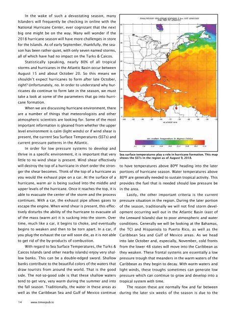
Sea surface temperatures play a role in hurricane formation. This map<br />
shows <strong>the</strong> SSTs in <strong>the</strong> region as <strong>of</strong> August 9, <strong>2018</strong>.<br />
to have temperatures above 80ºF heading into <strong>the</strong> later<br />
portions <strong>of</strong> hurricane season. Water temperatures above<br />
80ºF are generally needed to sustain tropical activity. This<br />
provides <strong>the</strong> fuel that is needed should low pressure be<br />
in <strong>the</strong> area.<br />
Lastly, <strong>the</strong> o<strong>the</strong>r important criteria is <strong>the</strong> current<br />
pressure situation in <strong>the</strong> region. During <strong>the</strong> later portion<br />
<strong>of</strong> <strong>the</strong> season, traditionally we will not find storm development<br />
occurring well out in <strong>the</strong> Atlantic Basin (east <strong>of</strong><br />
<strong>the</strong> Leeward <strong>Islands</strong>) due to poor atmospheric and water<br />
conditions. Generally we will be looking at <strong>the</strong> Bahamas,<br />
<strong>the</strong> TCI and Hispaniola to Puerto Rico, as well as <strong>the</strong><br />
Caribbean Sea and Gulf <strong>of</strong> Mexico areas. As we head<br />
into late October and, especially, November, cold fronts<br />
from <strong>the</strong> lower 48 states will move into <strong>the</strong> Caribbean as<br />
<strong>the</strong>y weaken. These frontal systems are essentially a low<br />
pressure trough that meanders in <strong>the</strong> warm waters <strong>of</strong> <strong>the</strong><br />
Caribbean as <strong>the</strong>y begin to decay. With warm waters and<br />
light winds, <strong>the</strong>se troughs sometimes can generate low<br />
pressure which can continue to grow and develop into a<br />
tropical system with time.<br />
The reason <strong>the</strong>se are normally few and far between<br />
during <strong>the</strong> later six weeks <strong>of</strong> <strong>the</strong> season is due to <strong>the</strong><br />
14 www.timespub.tc