Historic Rio Grande Valley
An illustrated history of the Rio Grande Valley area, paired with the histories of companies, families and organizations that make the region great.
An illustrated history of the Rio Grande Valley area, paired with the histories of companies, families and organizations that make the region great.

You also want an ePaper? Increase the reach of your titles
YUMPU automatically turns print PDFs into web optimized ePapers that Google loves.
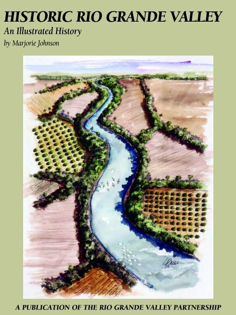
HISTORIC RIO GRANDE VALLEY<br />
An Illustrated History<br />
by Marjorie Johnson<br />
A PUBLICATION OF THE RIO GRANDE VALLEY PARTNERSHIP
Thank you for your interest in this HPNbooks publication. For more information about other<br />
HPNbooks publications, or information about producing your own book with us, please visit www.hpnbooks.com.
HISTORIC RIO GRANDE VALLEY<br />
An Illustrated History<br />
by Marjorie Johnson<br />
Published by the <strong>Rio</strong> <strong>Grande</strong> <strong>Valley</strong> Partnership<br />
<strong>Historic</strong>al Publishing Network<br />
A division of Lammert Publications, Inc.<br />
San Antonio, Texas
✧<br />
The ruins of Revilla, renamed Guerrero in<br />
1828, emerge from the waters of the Falcon<br />
Reservoir during times of drought.<br />
First Edition<br />
Copyright © 2001 <strong>Historic</strong>al Publishing Network<br />
All rights reserved. No part of this book may be reproduced in any form or by any means, electronic or mechanical,<br />
including photocopying, without permission in writing from the publisher. All inquiries should be addressed to<br />
<strong>Historic</strong>al Publishing Network, 8491 Leslie Road, San Antonio, Texas, 78254. Phone (210) 688-9006.<br />
ISBN: 1-893619-22-2<br />
Library of Congress Card Catalog Number: 2001093392<br />
<strong>Historic</strong> <strong>Rio</strong> <strong>Grande</strong> <strong>Valley</strong>: An Illustrated History<br />
author: Marjorie Johnson<br />
contributing writers for<br />
“sharing the heritage”: Marjorie Johnson<br />
Marie Beth Jones<br />
Eileen Mattei<br />
<strong>Historic</strong>al Publishing Network<br />
president: Ron Lammert<br />
vice president & project coordinator: Barry Black<br />
project representatives: Roger Smith<br />
Pat Steele<br />
Rob Steidle<br />
director of operations: Charles A. Newton, III<br />
administration: Angela Lake<br />
Donna Mata<br />
Dee Steidle<br />
graphic production: Colin Hart<br />
John Barr<br />
HISTORIC RIO GRANDE VALLEY<br />
2
CONTENTS<br />
4 FOREWORD<br />
5 CHAPTER I early history<br />
23 CHAPTER II part of four nations<br />
35 CHAPTER III the valley takes shape<br />
51 CHAPTER IV taming a wild country<br />
73 CHAPTER V the Civil War to 1900<br />
95 CHAPTER VI the twentieth century dawns<br />
103 CHAPTER VII cities grow along the railroad<br />
159 CHAPTER VIII entering the twenty-first century<br />
191 BIBLIOGRAPHY<br />
193 ACKNOWLEDGMENTS<br />
194 SHARING THE HERITAGE<br />
387 INDEX<br />
398 SPONSORS<br />
✧<br />
The Queen Isabella Causeway, longest<br />
bridge in Texas, spans 12,510 feet across<br />
the blue Laguna Madre from Port Isabel to<br />
South Padre Island. Pleasure boats that ply<br />
the Laguna’s peaceful waters and barge<br />
traffic on the Gulf Intracoastal Canal can<br />
move safely under the high causeway.<br />
CHAPTER I<br />
3
FOREWORD<br />
HISTORIC RIO GRANDE VALLEY is a project of the <strong>Rio</strong> <strong>Grande</strong> <strong>Valley</strong> Partnership in conjunction with <strong>Historic</strong>al Publishing Network<br />
of San Antonio. Though it deals specifically with the four counties of Cameron, Hidalgo, Starr and Willacy that comprise the <strong>Rio</strong> <strong>Grande</strong><br />
<strong>Valley</strong>, by necessity it deals with all of Texas and Mexico. Its purpose is to present in one volume the fascinating history of the <strong>Rio</strong> <strong>Grande</strong><br />
<strong>Valley</strong> from the first explorations by Europeans to the dynamic and driving forces that have propelled it into the new millennium. It is<br />
written in a readable, informal style with historic and current illustrations to provide a permanent record of the area’s settlement, growth<br />
and progress.<br />
The <strong>Rio</strong> <strong>Grande</strong> <strong>Valley</strong> is among the oldest and most historic areas of Texas. This relatively small region has lived through violent conflicts<br />
between early European settlers and Native Americans; witnessed battles that determined boundaries between rival nations of this<br />
continent; played a pivotal role in the Civil War; and spread the Spanish-Mexican cattle culture over Texas and the rest of the Southwest.<br />
The <strong>Rio</strong> <strong>Grande</strong> (“Big River” for those who are not bilingual), now the border between the United States and Mexico, winds through the<br />
area’s past, present and future. Spanish Colonial settlements, the ranching economy, trade routes, military campaigns and agricultural development<br />
of the early 1900s were defined by the river. Through the years towns of the borderland became intertwined through shared values<br />
of family, friendship, health and economic livelihood to form the cultural continuity that exists between the U.S. and Mexico in this area.<br />
Long accessible to the rest of the world only by sea and river steamboat, today the border region is open to the world. And that world<br />
is just beginning to learn about the area’s past, its people, and what they created in this land. For those who want to know more about<br />
this unique area at the tip of Texas, this book relates a fascinating story in words and pictures of how it got to be the <strong>Rio</strong> <strong>Grande</strong> <strong>Valley</strong><br />
of today.<br />
The publication of this keepsake book with its hundreds of historic and current illustrations was made possible by those who share<br />
their own history in the Heritage section of the book. They are part of the region’s past, present, and future. The sponsor and publisher<br />
appreciate their participation and you are invited to share their heritage as you explore the pages of HISTORIC RIO GRANDE VALLEY.<br />
Bill Summers,<br />
President/CEO<br />
<strong>Rio</strong> <strong>Grande</strong> <strong>Valley</strong> Partnership<br />
✧<br />
A map of the <strong>Rio</strong> <strong>Grande</strong> <strong>Valley</strong>.<br />
<strong>Rio</strong> <strong>Grande</strong> <strong>Valley</strong> Partnership<br />
P.O. Box 1499<br />
Weslaco, TX 78599-1499<br />
Phone: (956) 968-3141<br />
Fax: (956) 968-0210<br />
HISTORIC RIO GRANDE VALLEY<br />
4
EARLY HISTORY<br />
THE<br />
RIVER<br />
The international stream known as the <strong>Rio</strong> <strong>Grande</strong> in the United States and Río Bravo del Norte<br />
in Mexico has played an important part in the area since long before recorded history.<br />
The <strong>Rio</strong> <strong>Grande</strong> rises on the eastern face of the Continental Divide in southern Colorado. It<br />
winds eastward across southern Colorado and turns southward to cut across the whole length of<br />
New Mexico. Then it turns southeastward, except for the immense deviation known as the Big<br />
Bend, forming the boundary between Texas and Mexico.<br />
Along its way the <strong>Rio</strong> <strong>Grande</strong> receives few tributaries for so long a river. In Texas and Mexico<br />
the <strong>Rio</strong> Concho renews the river as it is about to die in the desert. The Pecos River, Devil’s River,<br />
and Río Salado are additional tributaries, as is the Río San Juan south of <strong>Rio</strong> <strong>Grande</strong> City, its last<br />
tributary as it winds its way toward the Gulf of Mexico.<br />
The romance and legends of the river have intrigued many writers through the years. Perhaps<br />
the most complete study was made by Paul Horgan, a Pulitzer Prize winner, for his monumental<br />
work, Great River—The <strong>Rio</strong> <strong>Grande</strong> in North American History, first published in 1954. In explaining<br />
the length of his 945-page, two-volume work, Horgan said:<br />
✧<br />
The <strong>Rio</strong> <strong>Grande</strong> (known as Río Bravo in<br />
Mexico) as seen from the historic plaza at<br />
Roma on its winding route along the U.S.-<br />
Mexico border to the Gulf of Mexico.<br />
COURTESY OF CRAIG WIEGAND.<br />
The river is nearly two thousand miles long. Its historical course takes us through something over ten<br />
centuries of time and through the chronicles of three cultures. To do it anything like justice, I have<br />
wanted to produce a historical experience rather than a bare record.<br />
That is what the publishers of this work hope to provide: A historical experience in words<br />
and pictures.<br />
The story of the <strong>Rio</strong> <strong>Grande</strong> is as varied as the meandering of its current. Yet this winding, sometimes<br />
treacherous and always muddy stream is the lifeblood of this fertile area. From it stems the<br />
region’s heritage, agriculture, and industry, as well as the water supply for its people.<br />
THE<br />
LAND<br />
On a map of the United States, the <strong>Rio</strong> <strong>Grande</strong> <strong>Valley</strong> hardly shows. Even on a Texas map it is a small<br />
part of a large state. Yet it has a fascinating history and has been of great importance in the life of<br />
CHAPTER I<br />
5
two nations. This work is designed to give a<br />
unique view of the region’s past as part of New<br />
Spain, Mexico, the Republic of Texas, and the<br />
United States as it enters the twenty-first century.<br />
The <strong>Rio</strong> <strong>Grande</strong> <strong>Valley</strong> is located in the<br />
southern tip of Texas and consists of the lands<br />
along the north bank of the <strong>Rio</strong> <strong>Grande</strong> in<br />
Starr, Hidalgo, Cameron, and Willacy<br />
Counties, covering 4,244 square miles. This is<br />
the region specifically considered in this<br />
book, although other parts of Texas and<br />
Mexico are included as they affect its history.<br />
Though called a “valley,” it is really a fertile<br />
flood plain, delta, and associated uplands of<br />
the <strong>Rio</strong> <strong>Grande</strong>. It is bounded on the east by<br />
the Laguna Madre, South Padre Island, and<br />
the Gulf of Mexico, on the west by Zapata<br />
County, on the north by Jim Hogg, Brooks,<br />
and Kenedy Counties, and on the south by<br />
the <strong>Rio</strong> <strong>Grande</strong>, the international boundary<br />
between the United States and Mexico.<br />
moderating effect on <strong>Valley</strong> temperatures. In<br />
general, summer highs are hotter and winter<br />
lows are cooler as the distance from the Gulf<br />
increases. Humidity is relatively high, with a<br />
daily average of 40 to 50 percent and a nightly<br />
average of about 90 percent.<br />
In the early part of its history, the land area<br />
was mostly covered with a dense growth of<br />
cactus, thorny shrubs and trees, including<br />
mesquite, huisache, and retama, and for a long<br />
time was considered unfit for settlement.<br />
When Stephen F. Austin passed through the<br />
area in 1823 on his way to Mexico City, he<br />
described the region as follows:<br />
The country between the Nueces and the<br />
<strong>Rio</strong> <strong>Grande</strong> is the poorest I ever saw in my life.<br />
It is generally nothing but sand, entirely void<br />
of lumber, covered with scrubby thorn bushes<br />
and prickly pear.<br />
The pages that follow document the region’s<br />
transition from wild chapparal country, with its<br />
thorny, low growing plants, into the irrigated<br />
farmlands and modern cities of today.<br />
THE<br />
COAHUILTECANS<br />
✧<br />
The land was covered with a dense growth<br />
of cactus, mesquite, and thorny shrubs.<br />
For a long time it was considered unfit<br />
for settlement.<br />
It is a smooth, nearly flat, coastal plain with<br />
a slope to the northeast, away from the <strong>Rio</strong><br />
<strong>Grande</strong> and toward the Gulf. Elevations range<br />
from sea level at the Laguna Madre to five<br />
hundred feet in the hilly areas of Starr County.<br />
Geologically, the <strong>Valley</strong>’s surface land is still in<br />
its youth, with sand, silt, and clay deposits of<br />
recent ages, which overlie more ancient fluvial<br />
deposits. Most of the soils are level, naturally<br />
fertile, easily cultivated, and suitable for irrigation.<br />
The <strong>Rio</strong> <strong>Grande</strong> <strong>Valley</strong> has a sub-tropical,<br />
semi-arid climate, characterized by short,<br />
mild winters and long, hot summers. The<br />
moisture-laden air from the Gulf has a<br />
Wandering tribes of nomadic Indians roamed<br />
the vast expanses of South Texas long before the<br />
Spaniards came. However, there were no wellestablished,<br />
permanent settlements as were<br />
found in the pueblo settlements of the upper <strong>Rio</strong><br />
<strong>Grande</strong> and other parts of the Southwest.<br />
Compared with such tribes, these natives were<br />
among the most primitive inhabitants of the<br />
continent. Called Coahuiltecans by scholars,<br />
they were related to the storied Karankawas of<br />
the upper Texas Gulf Coast. They were divided<br />
into several subgroups, of which the most<br />
numerous were the Carrizos.<br />
Bands within the groups consisted of up to<br />
two hundred individuals, but there was little<br />
social and economic cohesiveness. Their main<br />
occupation was finding enough food to eat.<br />
Their lives were affected greatly by the South<br />
Texas environment. Since no large animals<br />
inhabited the area, they depended on smaller<br />
animals such as deer, antelope, small javelinas,<br />
rabbits, and rodents. Those living along the<br />
<strong>Rio</strong> <strong>Grande</strong>, Salado, and San Juan Rivers often<br />
HISTORIC RIO GRANDE VALLEY<br />
6
supplemented their diets with fish taken with<br />
bow and arrow or nets. Most of their diet was<br />
vegetarian, however, with their staples being<br />
prickly pear, tuna, and mesquite beans. Large<br />
quantities of the beans were often gathered<br />
and thrown into a hole dug in the ground,<br />
where they were pounded with a wooden club<br />
into pulp.<br />
They consumed mescal, a potent<br />
intoxicating drink made from the leaves of<br />
agave, and drank a “tea” made from the peyote<br />
cactus, dried and ground into powder. They<br />
also ate peyote, both green and dried. Though<br />
neither a narcotic nor habit forming, it had a<br />
hallucinatory effect and was commonly used<br />
in religious ceremonies. It is still gathered by<br />
area natives and sold legally to members of the<br />
Native American Church in South Texas.<br />
The tribes engaged in intense warfare with<br />
each other, and feuds among tribal leaders were<br />
quite common. Combat usually consisted of<br />
small battles employing hit and run techniques,<br />
similar to the guerrilla warfare of the modern era.<br />
When the Spanish colonies were settled on<br />
the southern banks of the <strong>Rio</strong> <strong>Grande</strong>, some<br />
of the Indians were hostile, but others<br />
accepted the colonizers and welcomed the<br />
missions, where they lived and farmed under<br />
the supervision and protection of the priests.<br />
Such a mission was established near what<br />
was first called Revilla and later Guerrero.<br />
Called Ampuero, it was under the supervision<br />
of Fray Miguel Santa María de los Dolores,<br />
who described in detail some of the customs<br />
of the Indians. One of his stories relates to the<br />
mourning habits of the <strong>Rio</strong> <strong>Grande</strong> Indians:<br />
When an Indian mother lost a son, daughter<br />
or husband by death, she would go to some<br />
isolated place, taking with her other women of<br />
her household. In this place of seclusion, the<br />
women would pull out their hair and with the<br />
extraction of each strand would give a piercing<br />
scream, all others present joining in the<br />
outburst. This lasted days and weeks or as long<br />
as the pain caused by the loss of the deceased<br />
lasted, and the results were not a thing of beauty.<br />
The priest added that, in the case of a widow, as<br />
soon as someone else appeared to court her, that<br />
sorrow was soon forgotten and all effort used to<br />
again make herself attractive.<br />
He also described their successful methods<br />
of hunting: While hunting land animals they<br />
used great craftiness by forming a big circle<br />
over a larger area in the woods and slowly<br />
closed in around all the game. By this method<br />
they were able to kill a great deal of game.<br />
A cunning way was used to secure ducks.<br />
Placing baskets over their heads, they would<br />
dive under the water and reach up and grab<br />
the ducks by their feet, thereby catching all<br />
that were needed in a very short time.<br />
Contact with the Spaniards in the<br />
seventeenth and eighteenth centuries brought<br />
great disaster to the Coahuiltecans. Disease<br />
brought to the New World by the Spaniards,<br />
especially smallpox, spread to the Indians and<br />
destroyed entire bands and villages.<br />
Though some of the natives mixed and<br />
mingled with the Spanish settlers, the majority of<br />
the Coahuiltecans refused to settle and continued<br />
their nomadic lives until decimated by war,<br />
disease or both. By 1850, only a few of the once<br />
numerous Carrizo remained along the banks of<br />
the <strong>Rio</strong> <strong>Grande</strong>. Numerous pieces of pottery,<br />
stone tools, and campfire sites remain as evidence<br />
of the Coahuiltecans and their ancestors.<br />
THE FIERCE KARANKAWAS<br />
The Karankawas, those distant cousins of the<br />
Coahuiltecans, were a fierce five-tribe nation of<br />
✧<br />
The lifestyle and artifacts of Coahuiltecan<br />
Indians who once lived in the area are<br />
depicted in this exhibit at the Hidalgo<br />
County <strong>Historic</strong>al Museum, Edinburg.<br />
CHAPTER I<br />
7
coastal Indians whose greatest claim to fame was<br />
their practice of cannibalism. The men were<br />
giants in size, fine physical specimens ranging in<br />
height from six to seven feet. Their facial features<br />
were grotesque and their hair was as coarse as<br />
that of horses and worn long, often reaching to<br />
the waist. The women, worn by the drudgery of<br />
their lives, looked sullen and morose. They were<br />
fat, plain and even in youth not pretty.<br />
Numbering only a few thousand at any one time,<br />
they were scattered over some three hundred<br />
miles of Texas coastline from Matagorda Bay to<br />
the southern tip of Padre Island.<br />
They usually traveled in bands of 30 to 40<br />
people, seldom remaining in one place more than<br />
a month. They used little fleets of crude pirogues<br />
to move from island to island along the coast in<br />
search of food. Their main diet was fish, along<br />
with clams, mussels, tortoises, and alligators that<br />
they managed to catch in the rivers.<br />
In the spring they moved away from the<br />
fishing waters of the Gulf, going inland where<br />
there were wild dewberries, blackberries and<br />
mulberries to be had for the picking. The<br />
outing was in the nature of a picnic—the<br />
Indians remained in the woods for weeks,<br />
gorging themselves, dancing and enjoying the<br />
warm spring weather. With no permanent<br />
settlement to call home and no cultivated fields<br />
to maintain, the nomads spent their summers<br />
roaming from place to place; the men fishing<br />
and hunting, the women “grubbing for truffles.”<br />
Though engaged in constant struggles with<br />
the white men as they pushed their way into their<br />
domain, the “Kronks,” as they were called, did<br />
accept the Franciscan padres, who built four<br />
missions in a futile attempt to tame and<br />
Christianize them. The padres continually sought<br />
to bring the Indians into the various missions to<br />
teach them both religion and the delights of<br />
common labor. However, it proved an impossible<br />
task as the Kronks were interested in neither.<br />
In 1768 Fray José de Solís visited the region<br />
and wrote a vivid description of the<br />
Karankawas and their brother tribesmen from<br />
the coastal areas:<br />
These Indians are dirty, foul smelling, and<br />
pestiferous, and throw off such a bad odor<br />
from their bodies that it makes one sick. The<br />
men are keen-witted and shrewd and go about<br />
stark naked. They are cruel, inhuman and<br />
ferocious. They are so greedy that they eat<br />
meat almost raw, parboiled, or half-roasted<br />
and dripping with blood. They look upon<br />
their wives as simple instruments of pleasure<br />
in which the heart takes no part, not paying<br />
them the slightest attention.<br />
The Karankawas naturally resented the<br />
colonists and adventurers who confiscated land<br />
that the Indians had long considered their own,<br />
and they had trouble with almost everyone who<br />
crossed their path. This included the pirate Jean<br />
Lafitte when he attempted to establish his<br />
empire on Galveston Island in the early 1800s.<br />
They put up such a fight for their tribal land<br />
that the pirates called them “demons from hell.”<br />
According to available records, only<br />
approximately 250 Karankawas remained<br />
✧<br />
The fierce Karankawas lived along the<br />
seacoast and traveled in dugout canoes.<br />
There are many legends about these early<br />
inhabitants of the Texas coast.<br />
COURTESY OF THE PORT ISABEL HISTORICAL MUSEUM.<br />
HISTORIC RIO GRANDE VALLEY<br />
8
when the Texas colonists revolted against<br />
Mexico in 1836. Having lost most of the land<br />
over which they once roamed, they continued<br />
their wanderings along the coast and up and<br />
down the beaches of Padre Island, gradually<br />
sliding into extinction. There are many legends<br />
about these fierce natives, who established<br />
a niche for themselves by the obstacles<br />
they tossed in the paths of those who were<br />
attempting to bring civilization to the area.<br />
EARLY EUROPEAN<br />
EXPLORATIONS<br />
It was 1519, twenty-seven years after<br />
Columbus’ first voyage, before Hernán Cortés<br />
headed for the mainland of what became New<br />
Spain and then Mexico. As the Spaniards<br />
conquered the larger islands of Hispaniola,<br />
Cuba, and Jamaica, they established Spanishstyle<br />
governments, subjugated the natives, and<br />
tried to Christianize them. Cortés had sailed<br />
from Spain to Hispaniola in 1504 when he was<br />
only nineteen. There he settled as a farmer and<br />
public notary in a small town near Santo<br />
Domingo. He must have seen friends and<br />
neighbors sailing for glorious conquests and<br />
dreamed of such glory for himself. In 1511 he<br />
accompanied Diego Velásquez in his expedition<br />
to Cuba, where he became alcalde of Santiago<br />
for several years. Velásquez sent him to explore<br />
what is now Mexico in February 1519, and his<br />
great adventure began.<br />
Meanwhile, the Spanish governors of other<br />
island kingdoms had their own dreams of<br />
further conquests. In 1519, Francisco de Garay,<br />
who had been with Columbus on his second<br />
voyage, was the wealthy and ambitious governor<br />
of Jamaica. A strong rivalry had developed<br />
between Garay and Cortés, and Garay wanted to<br />
lay claim to some of the unexplored coast before<br />
Cortés claimed all of it. He sent an expedition of<br />
four vessels under the command of Alvarez de<br />
Piñeda to explore and lay claim to the area.<br />
Piñeda sailed north by Cuba and followed<br />
the Gulf coast toward the west, making detailed<br />
notes on the land, bays and rivers, the natives<br />
and the vegetation. He reached Veracruz in<br />
August, only to learn that Cortés had already<br />
been there. When Cortés learned of the arrival<br />
of this expedition, he feared the intruders would<br />
interfere with his conquest and occupation of<br />
Mexico. With some of his men he marched to<br />
where Piñeda’s ships were anchored and<br />
captured seven of the newcomers who had gone<br />
ashore. Piñeda didn’t stay around to meet Cortés<br />
personally, but sailed away to the north.<br />
RÍO DE LAS PALMAS<br />
After leaving Veracruz, Piñeda did not stop<br />
until he reached a “very large river” where there<br />
were many palms. He named it “Río de las<br />
Palmas” and went ashore to claim the land for<br />
Spain. His ships entered the mouth of this stream,<br />
where they spent forty days repairing the ships<br />
and exploring the country. A party of Spaniards<br />
went upstream about eighteen miles, where they<br />
found forty mud and reed Indian huts. The<br />
expedition then sailed back to Governor Garay<br />
with glowing reports of their findings and said the<br />
land was suitable for colonization.<br />
Because of the sabal palm jungle along the<br />
mouth of the <strong>Rio</strong> <strong>Grande</strong>, most historians<br />
have considered Piñeda’s river to be the <strong>Rio</strong><br />
<strong>Grande</strong>. In recent years, however, many<br />
believe that what Piñeda saw was the mouth<br />
of the Río Soto la Marina, some 120 miles<br />
south of the larger <strong>Rio</strong> <strong>Grande</strong>.<br />
Either way, it was in the neighborhood, and<br />
Governor Garay believed it was his destiny to<br />
establish a colony in his new territory. The<br />
following year, he got permission from the King<br />
to mount another expedition, and early in the<br />
✧<br />
Above: Spanish ships plied the seas in<br />
the early 1500s and explorers often<br />
competed with each other to claim new<br />
lands for Spain.<br />
COURTESY OF THE TREASURES OF THE GULF MUSEUM,<br />
PORT ISABEL, TEXAS.<br />
Below: Hernán Cortés feared the explorers<br />
under Piñeda would interfere with his<br />
conquering and occupying all of Mexico.<br />
This portrait was taken from Historia<br />
de Mexico.<br />
CHAPTER I<br />
9
✧<br />
This Piñeda tablet found by local Naval<br />
reservists looking for Civil War relics at<br />
Boca Chica Beach. It was buried several feet<br />
down under the remains of two wooden<br />
boats. Now on display in <strong>Rio</strong> <strong>Grande</strong> <strong>Valley</strong><br />
Museum, Harlingen, it has aroused much<br />
historical interest.<br />
summer of 1520 he sent Diego de Camargo to<br />
establish a permanent settlement. This<br />
expedition had three ships, 150 infantrymen,<br />
seven cavalrymen, brass cannon, a supply of<br />
brick and lime, and several masons. Camargo<br />
was to supervise the building of a fort at the<br />
mouth of the Río de las Palmas, from which<br />
missionaries would be sent to convert the native<br />
tribes and to keep Cortés from claiming the area.<br />
Historians agree that this expedition reached<br />
the <strong>Rio</strong> <strong>Grande</strong>. Camargo sailed upriver about<br />
twenty miles and found the native inhabitants<br />
friendly. These natives, however, soon tired of<br />
their visitors when they made demands for food,<br />
shelter, and women and decided to drive them<br />
away. Camargo tried to punish them, but was<br />
defeated, losing his horses and eighteen of his<br />
men. The remainder reached their ships and,<br />
pursued by hundreds of canoes filled with angry<br />
natives, succeeded in reaching the mouth of the<br />
river. One ship sank in the river and the other<br />
two were old and worm-eaten. Some of the<br />
strongest men decided to head for Veracruz<br />
overland. One ship reached Veracruz, but it<br />
sank three days later. Camargo, who was a<br />
former governor of Jamaica, and sixty of the<br />
survivors got permission from the commanding<br />
officer at Veracruz to march to Mexico City,<br />
where they joined Cortés.<br />
Still dreaming of establishing the colony of<br />
“Garay” and assuming that Camargo had built<br />
his fort at the mouth of the river, Garay<br />
organized a third voyage, which he led himself.<br />
The king of Spain had granted his request to<br />
establish a settlement in the land explored by<br />
Piñeda. He was directed to choose locations<br />
with a healthful climate not subject to floods<br />
and to give the natives instruction in the<br />
Catholic faith. By early summer of 1523, Garay<br />
was ready to head for the mouth of the <strong>Rio</strong><br />
<strong>Grande</strong>. He had sixteen vessels and 600 men,<br />
among them prominent residents of Jamaica<br />
and Cuba, supplies of provisions, 200 guns,<br />
300 crossbows, and several pieces of artillery.<br />
On St. James Day, July 25, 1523, his<br />
expedition sailed through a pass between two<br />
long islands, today’s Brazos Santiago Pass. To<br />
Garay’s surprise, no fort was found. An officer<br />
was sent upriver to find a site for the settlement,<br />
but returned after four days with the report that<br />
there were native villages further up, but the<br />
land was not suitable for a settlement. Though<br />
this was not true, Garay believed him. He<br />
commanded that four hundred of his men and<br />
all of his horses be landed so he could lead<br />
them overland to the Panuco River near<br />
present-day Tampico, where they would meet<br />
the ships and the rest of the men.<br />
The explorers encountered many<br />
difficulties on the long march across rivers<br />
and marshes. Horses drowned, hostile Indians<br />
attacked the men, mosquitoes and other<br />
tropical insects harassed them, and some of<br />
the men threatened mutiny. When they finally<br />
arrived at the Panuco, they fell into the hands<br />
of Cortés. Though treated with courtesy and<br />
allowed to spend time in Cortés’ home, the<br />
broken-hearted Garay died in less than a year.<br />
ANOTHER FAILED<br />
EXPEDITION<br />
While in Mexico, Garay met an old friend,<br />
Pánfilo de Narváez, who had been defeated<br />
and imprisoned by Cortés. Feeling sorry for<br />
this friend, he interceded with his captor,<br />
HISTORIC RIO GRANDE VALLEY<br />
10
equesting that Narváez be allowed to return<br />
to Cuba. Feeling that neither man could<br />
endanger his interests, Cortés agreed, gave his<br />
prisoner his freedom and bid him Godspeed.<br />
Tradition has it that, after Narváez was<br />
released from prison, he and the remnant of<br />
his men set out for Cuba. But Father Zamora<br />
and five officers gave up further plans to<br />
travel with Narváez and settled in Peñitas, just<br />
west of Mission, in the early 1520s, making<br />
Peñitas one of the oldest settlements in the<br />
United States. The refugees were befriended<br />
by Indians living in huts and dugout-type<br />
homes in the vicinity. But the Spaniards<br />
erected stone houses with whitewashed walls.<br />
Father Zamora brought the Catholic faith to<br />
the Indians, also teaching them weaving and<br />
better farming while the Indians taught<br />
cookery to their guests. Some of the<br />
descendants of this small band of refugees still<br />
live in the area and recall the stories handed<br />
down through the centuries, though no<br />
physical evidence remains of the early<br />
settlement in present-day Peñitas.<br />
As soon as he reached Cuba, Narváez started<br />
planning another journey to explore Florida and<br />
the Gulf Coast. This turned out to be the most<br />
disastrous expedition of all. Narváez left Cuba in<br />
1527 with sixteen ships and 750 men, among<br />
them Alvar Nuñez Cabeza de Vaca, comptroller<br />
and royal treasurer. Their ships got lost, then<br />
shipwrecked, and for seven long years nothing<br />
was heard of Narváez. Then in 1536, north of<br />
Culiacán, Mexico, a Spanish slave-gathering<br />
expedition came upon four starving, almost<br />
naked and destitute men. The leader of the party<br />
was none other than Cabeza de Vaca. With him<br />
were Alonso del Castillo Maldonado, Andrés<br />
Dorantes, and Estevanico, a black Moorish slave<br />
belonging to Dorantes. They were the only<br />
survivors of the ill-fated Narváez expedition.<br />
They recounted one of the great adventures<br />
of all time. Shipwrecked on Galveston Island,<br />
they were passed from native tribe to tribe,<br />
sometimes as slaves, at other times sought<br />
after. In the seven years of their wanderings<br />
they saw no sign of white men. In their<br />
travels, they passed through the <strong>Rio</strong> <strong>Grande</strong><br />
<strong>Valley</strong>. They had an opportunity to observe<br />
the natives who lived in the area, finding<br />
them no better than the barbarous tribesmen<br />
who had mistreated them all along their<br />
torturous journey.<br />
ORDER COMES TO<br />
NEW SPAIN<br />
Once the conquest of New Spain was<br />
accomplished, King Carlos I knew a more<br />
orderly government was needed than could<br />
be provided by Cortés and the interim<br />
government in Mexico City of the audencia, a<br />
court of judges. A viceroy, a personal<br />
representative of the crown appointed by the<br />
king to govern a territory, was needed.<br />
Fortunately, he chose Antonio de Mendoza as<br />
the first viceroy in 1535, and he served until<br />
1550. A man of exceptional background and<br />
talents, he established the basic foundation of<br />
colonial government in New Spain.<br />
He desired to preserve the Indian class<br />
structure and advocated proper food and<br />
clothing, decent wages, and protection of their<br />
health. The Indians used human burden<br />
carriers as they had no beasts of burden. Nor<br />
did they have the wheel. Mendoza gradually<br />
eliminated the custom through the introduction<br />
of beasts of burden, carts, and road<br />
construction. Agriculture was encouraged, and<br />
the livestock of the Spaniards was introduced<br />
—horses, mules, oxen, cows, sheep, goats and<br />
pigs. A cattle association was formed as early as<br />
1542. Gold and silver mines were developed, as<br />
the primary interest of the Spanish Crown lay in<br />
the wealth they could produce.<br />
To Mendoza belongs the honor of setting<br />
up the first printing press in the New World.<br />
Early religious publications were followed<br />
by books on mathematics, physics, navigation<br />
and law codes, all before 1600. He was also a<br />
strong advocate of education and supported<br />
Franciscan Bishop Juan de Zumarraga in his<br />
efforts to establish a university, which was<br />
founded in 1553, two years after the viceroy<br />
had left his Mexican post. Nevertheless, he<br />
deserves to be listed among the founders of<br />
the present-day National University of<br />
Mexico, which, along with the University of<br />
San Marcos in Lima, Peru, are the oldest<br />
universities in the Americas.<br />
During the three hundred year colonial<br />
period, New Spain was to have sixty-two<br />
✧<br />
The Spaniards became very demanding of<br />
the natives who, though friendly at first,<br />
soon tired of their visitors and their<br />
demands. The natives attacked the<br />
Spaniards, driving them back to their ships.<br />
COURTESY OF THE TREASURES OF THE GULF MUSEUM,<br />
PORT ISABEL, TEXAS.<br />
CHAPTER I<br />
11
✧<br />
Above: A member of the failed Narvaez<br />
expedition, Alvar Núñez Cabeza de Vaca<br />
was shipwrecked on Galveston Island. After<br />
seven years he and three companions made<br />
their way across Texas and into Mexico.<br />
What a story they had to tell!<br />
Below: Twenty heavily loaded ships that<br />
sailed from Veracruz for Spain in 1553<br />
were buffeted by wind and rain. A large<br />
part of the fleet, spars broken and sails<br />
carried away, was grounded on the<br />
sandbars off Padre Island.<br />
COURTESY OF THE TREASURES OF THE GULF MUSEUM,<br />
PORT ISABEL, TEXAS.<br />
viceroys, some of whom were good choices<br />
while other unfortunate selections were<br />
corrupt and incompetent. But under<br />
Mendoza’s leadership, New Spain was<br />
launched on an orderly course from which<br />
grew the great colonial civilization of Mexico,<br />
which is the foundation of the bicultural<br />
heritage of the <strong>Rio</strong> <strong>Grande</strong> <strong>Valley</strong>.<br />
THE GREAT SHIPWRECK<br />
OFF PADRE ISLAND<br />
On an early summer day in 1553, a fleet<br />
stood at anchor by the waterfront of Veracruz.<br />
Twenty vessels with 2,000 passengers,<br />
among them some of the most illustrious<br />
names in New Spain, were sailing for home,<br />
loaded with gold and silver bars and casks of<br />
precious cargo.<br />
Finally all the cargo was loaded and<br />
everything was in readiness, so the vessels set out<br />
across the Gulf, docking at Havana for provisions<br />
and visits with their New World friends.<br />
When the time came for them to depart,<br />
there was a fanfare of trumpets as the treasure<br />
flotilla hauled up anchors and the travelers<br />
waved their last farewells to friends on shore.<br />
Among those on the ships were some of the<br />
old conquistadores, merchants with their<br />
families, colonists returning after years in<br />
Mexico, and the beautiful Doña Juána Ponce<br />
de León. Their savings, belongings, tax money<br />
for the King, and tons of bulky cargo were<br />
stuffed tight in the holds.<br />
But the flotilla had lingered too long in<br />
Havana, and when it prepared to sail the<br />
hurricane season was well upon them. On the<br />
second morning out of port, the first ominous<br />
warnings of trouble were noted. By noon the<br />
next day, heavy clouds blotted out the sun,<br />
and rain closed in fast, drenching the deck<br />
hands as they scrambled through their storm<br />
preparations. The wind rose to a howling gale,<br />
lashing the ships with awesome fury. Three of<br />
the heavily laden vessels quickly floundered<br />
and sank, losing all aboard. Five ships made it<br />
to safety: one managed to return to Cuba,<br />
three limped back to Spain six months later,<br />
and one fought its way back to Veracruz. The<br />
rest of the fleet, spars broken and sails carried<br />
away, was driven swiftly across the Gulf of<br />
Mexico and grounded on the sandbars off<br />
Padre Island, somewhere between Corpus<br />
Christi and Brazos Santiago Pass.<br />
Only three hundred of those on board<br />
reached shore and, as they thought, safety. The<br />
rest drowned, a fate more kindly than the one<br />
that awaited the survivors. The strongest swam<br />
in and made their way through the breakers.<br />
Some improvised rafts, and those too weak to<br />
help themselves were washed in and pulled<br />
from the surf by those on shore. There was not<br />
an Indian village, not a living thing except the<br />
white gulls overhead—only a sandy waste.<br />
They did have one lucky break when cartons of<br />
bacon and casks of sea biscuit washed in from<br />
the ships, along with two good crossbows, five<br />
quivers of arrows and several swords.<br />
The 300 rested for six days on the beach<br />
and saw no living soul, but on the seventh<br />
morning they awoke to find themselves<br />
surrounded by naked, hideously painted,<br />
brown men of huge stature. They were<br />
Karankawa Indians and were friendly at first,<br />
but then started shooting arrows at them. The<br />
Spaniards tried to fight back with their<br />
crossbows, but were no match for their<br />
tormentors. The wretched refugees then<br />
moved along the beach, slipping from dune to<br />
dune, hunted all the way down to the end of<br />
the Island, tortured and finally killed by their<br />
pursuers. A few of the Spaniards reached the<br />
HISTORIC RIO GRANDE VALLEY<br />
12
mouth of the <strong>Rio</strong> <strong>Grande</strong>, near Brownsville<br />
and crossed over to the mainland, still<br />
pursued by the savages.<br />
Only two of the 300 survived the terrible<br />
ordeal and lived to tell about it. Francisco<br />
Vásquez, who had doubled back to the shipwrecks<br />
under cover of darkness, stayed with<br />
the broken ships. He survived by eating<br />
seafood. He also found he could get fresh<br />
water by digging with his hands or a piece of<br />
driftwood, and this saved his life. He had<br />
been at the docks when the valuable cargo<br />
was loaded, and knew that eventually the<br />
Spaniards would come looking for the<br />
wrecks. It was half a year later that the salvage<br />
ships came, and Vásquez was a great help to<br />
them while they raised much of the cargo<br />
with grappling hooks. His share made him a<br />
wealthy man, and he enjoyed a long life.<br />
Fray Marcos de Mena was the other survivor.<br />
He had six arrows in his body, one in an<br />
eye, but he pulled them out and struggled on<br />
with the help of his companions. Finally,<br />
when he could go no further, he begged his<br />
friends to leave him to die. He lapsed into a<br />
coma and his companions laid him in the<br />
shade and covered him with sand, leaving<br />
only his head exposed. When he awoke, he<br />
followed the tracks of the others until he came<br />
to their bodies. He trudged ahead for days<br />
until he finally reached a stream near Panuco<br />
where friendly Indians found him and took<br />
him to their camp. They nursed him back to<br />
strength, and eventually he was able to return<br />
to his people to tell the sad story of the death<br />
march of his companions.<br />
THE SEARCH FOR INTRUDERS<br />
coast. In 1684 the French nobleman, La Salle,<br />
was driven westward by storms while searching<br />
for the mouth of the Mississippi, where he<br />
hoped to plant a colony. He landed on the<br />
coast of Texas near Lavaca Bay, where he<br />
established his fort, but it soon failed from<br />
dissension among the men and raids by<br />
Indians. Alonzo de León was sent from<br />
Cadereyta to find the settlement, but he failed<br />
to go far enough on his first three tries.<br />
Finally, on his fourth expedition he succeeded<br />
in locating the ruins of the French colony. The<br />
Spaniards realized that the French were no<br />
longer a threat, and another hundred years<br />
would go by before they got serious about colonizing<br />
the untamed area north of the Panuco<br />
called Seno Mexicano.<br />
THE ESCANDÓN<br />
COLONIZATION<br />
✧<br />
At first the shipwreck survivors were treated<br />
kindly by the Karankawa Indians, but soon<br />
they began to torment the wretched refugees<br />
until only 2 of 300 survived. This mural was<br />
painted by Ramon Claudio in Raymondville.<br />
COURTESY OF GLENN HARDING.<br />
In 1638 rumors spread that a group of<br />
strange men had landed on the coast to the<br />
northeast, in what is now Texas. The Indians<br />
reported that these intruders had blonde<br />
beards and hair, wore red socks and steel plate<br />
armor and had powerful guns. This alarmed<br />
the rulers of both Spain and New Spain, but<br />
search parties that were sent out to find<br />
encroachers found nothing.<br />
France gave the Spaniards their greatest<br />
cause for alarm, and rumors of their activities<br />
resulted in several expeditions to the Texas<br />
It was 1743, or more than two hundred<br />
years after the first viceroy came to Mexico<br />
City, that Spain made plans to tame the long<br />
ignored wild lands of northern Mexico. The<br />
responsibility for selecting a leader for the subjugation<br />
and settlement of these lands was delegated<br />
to the Audiencia de México (the highest<br />
court). The boundaries of the province, which<br />
they named Nuevo Santander, were defined:<br />
Tampico on the south; La Bahía del Espíritu<br />
Santo at the mouth of the San Antonio River<br />
on the north; the Gulf of Mexico on the east;<br />
CHAPTER I<br />
13
✧<br />
Above: José de Escandón, count of Sierra<br />
Gorda, the father of the <strong>Rio</strong> <strong>Grande</strong> <strong>Valley</strong>.<br />
Below: Texas historical marker beside U.S.<br />
281 west of Brownsville tells of the Alonzo<br />
de León expeditions from 1686-1688 in<br />
search of the French settlement of Fort St.<br />
Louis in the Matagorda Bay area. The<br />
remains were finally discovered and<br />
destroyed. De León led an expedition into<br />
Southeast Texas in 1690 that established the<br />
area’s first Spanish mission, San Francisco<br />
de los Tejas, and eventually led to Spain’s<br />
great enterprise of colonizing Texas.<br />
and the Sierra Madre Mountains on the west.<br />
Thus it included the <strong>Rio</strong> <strong>Grande</strong> <strong>Valley</strong>.<br />
Therefore, the organization of this province<br />
is a major force in the history of the <strong>Rio</strong><br />
<strong>Grande</strong> <strong>Valley</strong>. Lands on both sides of the <strong>Rio</strong><br />
<strong>Grande</strong> were a part of Nuevo Santander from<br />
1746 to 1821.<br />
The Audiencia realized how important it<br />
was to select just the right person for this<br />
mammoth undertaking. Several leaders of the<br />
frontier applied for the post and presented<br />
plans for the colonization. In 1746 they found<br />
their man, and by all records it was an<br />
excellent choice.<br />
He was José de Escandón, a native of Spain<br />
born at Soto de Marina in 1700 into a<br />
distinguished family. At fifteen he had left his<br />
home, crossed the Atlantic, and enlisted in the<br />
Spanish army as a cadet, serving first in the<br />
Yucatán and then in Querétaro, where he married<br />
into a noble family. He advanced through the<br />
ranks to colonel, then was named conde (count)<br />
de Sierra Gorda. He was especially noted for<br />
subduing barbarous tribes of Indians and then<br />
treating them with consideration, permitting no<br />
outrages against them.<br />
It was from Querétaro, his headquarters for<br />
twenty years, that he organized his expedition<br />
to subjugate the Indians and colonize the vast<br />
reaches of Seno Mexicano, which became the<br />
province of Nuevo Santander. It covered what<br />
today includes Tamaulipas, part of Nuevo León,<br />
and much of South Texas. An efficient colonizer<br />
and strong leader, he inspired confidence and<br />
respect in those he met. He spent almost two<br />
years preparing a survey expedition, and in the<br />
last months of 1746 completed preparations for<br />
the journey. Escandón left Querétaro on<br />
January 7, 1747 with a military detail of one<br />
captain, two sergeants, ten soldiers, several<br />
servants, a surgeon, two Spanish missionaries,<br />
and a large amount of equipment and food. His<br />
party traveled east and north toward the mouth<br />
of the <strong>Rio</strong> <strong>Grande</strong>.<br />
Meanwhile, seven divisions, consisting of a<br />
total of 765 soldiers, proceeded from seven<br />
points on the frontier, all bound for the<br />
mouth of the <strong>Rio</strong> <strong>Grande</strong>, where they were<br />
scheduled to meet about February 24, 1747.<br />
Three divisions came out of the south and<br />
three from the provinces on the west. One<br />
came down from the mission of La Bahía del<br />
Espíritu Santo at the northern edge of Seno<br />
Mexicano, for they wanted to explore the<br />
territory between San Antonio and the Nueces<br />
and on to the <strong>Rio</strong> <strong>Grande</strong>. It is said that up to<br />
that time, many thought the Nueces and the<br />
<strong>Rio</strong> <strong>Grande</strong> were the same stream.<br />
Escandón was to await his men somewhere<br />
near the mouth of the <strong>Rio</strong> <strong>Grande</strong>, where they<br />
would map the region and make future plans.<br />
Indian chieftains along the way made friendly<br />
advances to Escandón, who then employed<br />
them as scouts for the expedition. One of<br />
these, Chief Santiago, directed the party to a<br />
campsite on the south bank of the <strong>Rio</strong><br />
<strong>Grande</strong>, where the colonizer spent several<br />
weeks receiving his captains and studying<br />
their findings.<br />
Six of the scouting parties reached him<br />
near the scheduled time. The group from the<br />
north missed the route and crossed upstream<br />
at El Cantaro Ford near Mier. Messengers<br />
from Escandón’s headquarters accepted their<br />
findings, and then had them return to their<br />
base on the Texas coast. They reported that<br />
the Nueces and the <strong>Rio</strong> <strong>Grande</strong> were two<br />
rivers instead of one with a large expanse of<br />
land in between, and that the Nueces flowed<br />
into the Gulf nearly two hundred miles north<br />
of the <strong>Rio</strong> <strong>Grande</strong>.<br />
The captains of the other teams reported that<br />
the three principal streams emptying into the<br />
<strong>Rio</strong> <strong>Grande</strong> were the Salado, the Alamo, and the<br />
San Juan. They recommended settlement sites<br />
near the juncture of each of these with the <strong>Rio</strong><br />
<strong>Grande</strong> as there was the possibility of irrigating<br />
HISTORIC RIO GRANDE VALLEY<br />
14
adjacent lands. The Indian problem had<br />
proven far less serious than anticipated, though<br />
there were many tribes who spoke different<br />
dialects, making communication difficult. The<br />
native population in the vicinity of the <strong>Rio</strong><br />
<strong>Grande</strong> was estimated at approximately twentyfive<br />
hundred.<br />
Escandón had been gone from Querétaro<br />
only three months when he returned, the survey<br />
having gone smoothly with no loss of life. He<br />
prepared his report for the viceroy and<br />
requested adequate funding for the next stage of<br />
the colonization. His plans called for<br />
establishing fourteen settlements north of<br />
Tampico within seven months. A great<br />
promoter, Escandón spread the word about the<br />
colonies in every established town along the<br />
frontier, pointing out the advantages he found in<br />
Nuevo Santander. He told of the free land, fertile<br />
soil, agreeable climate, and an opportunity to<br />
have a part in the making of a new country.<br />
In establishing a villa or settlement, the first<br />
step was to select a suitable site where a water<br />
supply was assured. After the selection of a site,<br />
the streets were marked off around the plaza,<br />
which was one hundred and twenty-four varas<br />
square—about three hundred and fifty feet.<br />
Next to the villa were the common lands<br />
designated for agriculture, and beyond these<br />
were the pasturelands. Mission property for the<br />
church was usually allocated. The towns<br />
developed gradually. First the military camp<br />
changed to a municipality; then many of the<br />
solders married into the local families and<br />
became attached to the locality, eventually<br />
becoming permanent settlers.<br />
The Spaniards, in their zeal to teach<br />
Christianity to the Indians, sent their missionary<br />
priests along with the first colonizers. They were<br />
valuable in helping with the establishment of<br />
villas and compiling the laws, as well as<br />
gathering the Indians into their missions. In the<br />
beginning, twelve priests were assigned to the<br />
new colony of Nuevo Santander, all from the<br />
College of Zacatecas. Initially, they were paid by<br />
the government. Escandón cooperated with the<br />
priests in urging community life to the Indians<br />
and by pointing out the advantages of living<br />
under the protection of priests and soldiers.<br />
Because the new colony of Nuevo<br />
Santander was so remote from the capital,<br />
many decisions concerning its government<br />
were made by Escandón, its governor and<br />
capitán general, rather than waiting for royal<br />
orders from the viceroy. In addition to the<br />
ordinary concessions provided to the colonizer<br />
by the Crown, the governor also benefited<br />
from the opportunity to make money through<br />
the commissary plan. Payment of soldiers was<br />
made chiefly in provisions, purchased by<br />
Escandón and his commanders and charged to<br />
the soldiers at a profit. Thus the post of<br />
governor was also that of merchant.<br />
The first settlements in Nuevo Santander<br />
were interior settlements in Mexico in what is<br />
now Tamaulipas. These included Santander,<br />
renamed Jiménez in 1827, which became the<br />
capital of the new province and Escandón’s<br />
headquarters. But the emigrants from Nuevo<br />
León and Coahuila were more interested in the<br />
<strong>Rio</strong> <strong>Grande</strong> country, which had been pictured<br />
to them as a great fertile valley offering<br />
wonderful opportunities for agriculture and<br />
stock raising by those who had taken part in<br />
the original survey expedition two years earlier.<br />
THE FIRST RIO GRANDE<br />
SETTLEMENT<br />
José María de la Garza Falcón had been one<br />
of the captains on the initial survey expedition.<br />
A person of considerable influence in Nuevo<br />
León, he had many family connections. He<br />
persuaded his brother, Miguel, his father-in-law,<br />
and other relatives to sign up with him for the<br />
site near the juncture of the San Juan and the<br />
✧<br />
Querétaro, Escandón’s headquarters for<br />
many years, was a well-developed colonial<br />
city in the 1700s. It is famous for its<br />
aqueduct, built between 1726 and 1738,<br />
which brought water to the city from the<br />
surrounding mountains.<br />
CHAPTER I<br />
15
✧<br />
This Spanish map of the Seno Mexicano<br />
region shows a 1792 date. All of the<br />
Escandón settlements are shown, but the<br />
many inaccuracies on the U.S. side show<br />
that little exploration of the territory<br />
had occurred.<br />
HISTORIC RIO GRANDE VALLEY<br />
16<br />
<strong>Rio</strong> <strong>Grande</strong>. He wanted to be named captain of<br />
the villa, which carried a handsome salary and<br />
double the land of an ordinary settler.<br />
These colonists were a fine class of Spaniards,<br />
but were accustomed to the hardships of the<br />
frontier. They realized that to make a success in<br />
this new country they would have an everyday<br />
struggle for family, food, and land. Determined<br />
to succeed, they insured their future by taking<br />
with them into the new province their livestock,<br />
consisting of cattle, horses, goats, and sheep,<br />
and as many of their household goods as could<br />
be carried. The women slipped in among the<br />
necessary articles flower and fruit seed, valued<br />
heirlooms, medicines, small pieces of<br />
needlecraft, dishes and silver, common in the<br />
rich mining districts of Nuevo León.<br />
The party arrived at the site and awaited<br />
Escandón and his group. While waiting, they<br />
made a clearing, erected crude huts, dug a few<br />
irrigation ditches and made other preparations<br />
necessary to make a good showing for El Conde.<br />
Escandón reached the campsite early in March,<br />
and soon all were ready for the founding of the<br />
first of the <strong>Rio</strong> <strong>Grande</strong> settlements, which they<br />
decided to call Santa Ana de Camargo.<br />
The priests wanted some semblance of a<br />
church, and the men hurriedly erected an arbor<br />
using poles from both sides of the <strong>Rio</strong> <strong>Grande</strong>.<br />
On March 5, 1749, Villa Santa Ana de Camargo<br />
was officially christened by Escandón and Blas<br />
María de la Garza Falcón was successful in being<br />
named captain. At the sounding of the drum,<br />
the soldiers and settlers gathered in the open<br />
plaza in front of the crude arbor. The church was<br />
blessed, and Escandón addressed the captain,<br />
administering to him the oath to defend the villa<br />
and comfort and encourage the settlers. Mass<br />
was then sung, a volley was discharged in honor<br />
of the occasion, and the soldiers and settlers<br />
went to their jacales. The captains and jefes<br />
concluded the ceremony as they drank wine<br />
from silver goblets to the health of their great<br />
leader and gave him thanks.<br />
Thus was born the first Spanish settlement<br />
along the <strong>Rio</strong> <strong>Grande</strong>. A garrison was set up<br />
and Captain de la Garza Falcón was left in<br />
charge of the original settlers, forty families<br />
from the province of Nuevo León. A mission<br />
was established south of the villa on the Río<br />
San Juan, with Fray Marquís left in charge.<br />
Today, Camargo, located six miles south of<br />
<strong>Rio</strong> <strong>Grande</strong> City, is still a thriving agricultural<br />
community and home to several thousand<br />
residents who take great pride in their town<br />
and its history.<br />
THE SETTLEMENT OF REYNOSA<br />
Much the same procedure was used in the<br />
establishment of succeeding settlements. The<br />
second villa was established downstream,<br />
Nuestra Señora de Guadalupe de Reynosa,<br />
with Carlos Cantú as captain. The first forty<br />
settlers came with him from Cadereyta and<br />
other Nuevo León settlements. These settlers<br />
received one hundred pesos as a subsidy for<br />
each family and enough grain and other food
for their first year. A mission was established<br />
nearby with Fray Agustín Fragoso in charge.<br />
Reynosa was the last settlement made<br />
toward the east, as the lands near the coast<br />
were thought unsuitable for settlement since<br />
the settlers would need to depend on agriculture<br />
for a livelihood, and because hundreds of<br />
Indians inhabited the coastal plains.<br />
The original site chosen for Reynosa was<br />
prone to flooding, so the town was moved to<br />
its present site on higher land in 1802.<br />
Reynosa was to become the largest of the<br />
Escandón colonies, with a strong manufacturing,<br />
agricultural, industrial, trade, and service<br />
economy. It is a blend of old and new, an<br />
interesting place to visit.<br />
Within six months, counting those<br />
settlements further south in Mexico,<br />
Escandón had established thirteen villas and<br />
missions in the region. Though the project<br />
cost twice the amount budgeted, the<br />
Audencia was quite pleased at the work of the<br />
colonizer and he was encouraged to continue<br />
with the settlements.<br />
Though Escandón had planned to establish<br />
two settlements north of the <strong>Rio</strong> <strong>Grande</strong> near<br />
the Nueces, scouts who were sent out to see if<br />
they could find suitable locations returned<br />
after eight difficult months to report adversely<br />
on the tentative sites chosen. As a result, plans<br />
for further settlements in the upper portions<br />
of the colony were abandoned.<br />
The first settlement north of the <strong>Rio</strong><br />
<strong>Grande</strong> in what is now Texas was established<br />
by Coahuila rancher José Vásquez Borrego,<br />
who had a ranch upriver from Revilla and<br />
wanted to establish a villa. In the late summer<br />
of 1750, Borrego settled Nuestra Señora de los<br />
Dolores with twelve families. It became more<br />
a ranch headquarters than a town, and its<br />
structure was very military and authoritarian.<br />
It also was subject to raids from hostile tribes<br />
of Indians. In the first decades of the<br />
nineteenth century, Indians struck the<br />
settlement repeatedly with a terrible fury.<br />
People were killed, women and children<br />
carried off as captives, cattle were taken, and<br />
the raiders even killed Borrego’s oldest son,<br />
who had charge of the place. Eventually the<br />
settlement was abandoned and only its ruins<br />
can be seen today.<br />
REVILLA AND MIER<br />
After establishing his headquarters and home<br />
along the Río Santander at Jiménez, Escandón<br />
again headed for the <strong>Rio</strong> <strong>Grande</strong> for another<br />
colonization expedition in early 1750. He had<br />
received a proposal from Vicente Guerra, a<br />
rancher from the province of Coahuila, to settle<br />
twenty-six families at Revilla, near the juncture<br />
of the Salado and the <strong>Rio</strong> <strong>Grande</strong>. Guerra asked<br />
only for the rights and title of a colonizer<br />
without expense to the government. The villa of<br />
Revilla (known since 1828 as Guerrero) was<br />
established and its growth was rapid.<br />
Within three years there were forty-three<br />
families with thousands of cattle, goats, sheep<br />
and horses pastured over the surrounding<br />
country, which was much better adapted for<br />
ranching than farming. Known for the attractive<br />
architecture of its stone buildings, it prospered<br />
well into the twentieth century. However, its<br />
economy had declined, and its population had<br />
dwindled to a few thousand by the time it was<br />
abandoned in 1952, when it was partially<br />
submerged by the construction of Falcon Dam<br />
reservoir. Nuevo Guerrero, just across the<br />
international crossing at Falcon Dam, was built<br />
in the early 1950s to relocate the residents of<br />
Guerrero Viejo. The bell from its historic<br />
church by the old plaza now rings from the<br />
church by the plaza at Nuevo Guerrero.<br />
In recent years the ruins of Guerrero Viejo<br />
have emerged from the waters of Falcon Lake,<br />
✧<br />
Above: Camargo’s well-preserved<br />
Presidential Palace faces the plaza and is<br />
occupied by city officials.<br />
Below: The Catholic Church of Santa Ana<br />
faces the plaza and is the oldest building<br />
in Camargo. Built in the 1750s, the church<br />
has been carefully restored and is used by<br />
the citizenry.<br />
CHAPTER I<br />
17
✧<br />
Reynosa, which had a population of only<br />
two thousand in 1842, has grown to become<br />
one of the largest cities along the border.<br />
This well maintained Catholic church by the<br />
main plaza was built in the 1800s and has<br />
seen many renovations.<br />
as they do any time the lake level drops. The<br />
site has become a popular destination for<br />
visitors from both sides of the <strong>Rio</strong> <strong>Grande</strong>.<br />
In 1752, two years after Revilla was established,<br />
Lugar de Mier was founded upstream<br />
along the banks of the Alamo River near the<br />
<strong>Rio</strong> <strong>Grande</strong>. José Florencio de Chapa was in<br />
charge and thirty-eight families arrived from<br />
Cerralvo, only sixty miles away.<br />
Already there were nineteen families living<br />
on ranches in the area, and they joined the<br />
newcomers to establish the villa of Mier. Since<br />
no priest was provided at this new settlement, it<br />
was impossible to develop the work among the<br />
Indians with only an occasional visit from a<br />
circuit priest.<br />
Mier was located near the best ford on the<br />
lower <strong>Rio</strong> <strong>Grande</strong>, El Cantaro, which had already<br />
been used extensively for crossing from the salt<br />
lakes located to the north. Limestone was readily<br />
available, so more permanent homes were erected<br />
there than at most of the other settlements.<br />
Today, a visit to Mier takes one back to<br />
earlier days, as some of the old limestone walls<br />
and buildings can be seen alongside modern<br />
structures. Mier is a gem of an interior town,<br />
with well-kept homes, churches and schools.<br />
THE SETTLEMENT OF<br />
CARNESTOLENDAS<br />
In January 1753 Escandón made another<br />
visit to the new settlements. The census was<br />
encouraging, showing an increase in<br />
population. While he was in the <strong>Valley</strong>, the<br />
settlers made their first petition for the<br />
individual allocations of lands, and some of the<br />
people of Camargo asked for land on the north<br />
side of the <strong>Rio</strong> <strong>Grande</strong> in a place known as<br />
Carnestolendas, now <strong>Rio</strong> <strong>Grande</strong> City. Captain<br />
Blas María de la Garza Falcón had chosen a high<br />
hill overlooking the river for his ranch<br />
headquarters and his herds roamed in the valley<br />
north of the <strong>Rio</strong> <strong>Grande</strong> and over the hills and<br />
plateau to the north. Don Nicolás de los Santos<br />
Coy, his father-in-law, had established his ranch<br />
to the west about nine miles and had named it<br />
Guardado (now Garceño).<br />
Don Nicolás was a very wealthy man, and<br />
reports from the time show that he employed<br />
more than a hundred men to work his two<br />
ranches, the second one on the south side of the<br />
river. Together, the de la Garza Falcón and de<br />
los Santos Coy families were awarded one<br />
hundred sitios (442,800 acres) of land north of<br />
the river, with the provision that they settle<br />
fifteen additional families on the land at their<br />
own expense.<br />
THE LAST OF THE COLONIES<br />
Escandón established the last of the<br />
colonies on the <strong>Rio</strong> <strong>Grande</strong> in May 1755. He<br />
gave permission to Don Tomás Sánchez to<br />
settle on a ranch about thirty-five miles<br />
northwest of Dolores on the north bank of the<br />
<strong>Rio</strong> <strong>Grande</strong>. Sánchez was born in 1709 near<br />
Monterrey, and his early career began in the<br />
military on the northern frontier. Later he was<br />
a rancher in the province of Coahuila. Fifteen<br />
leagues of land, about 66,000 acres, were<br />
included in the Sánchez grant.<br />
Sánchez was commissioned a captain, but no<br />
military garrison was provided and the settlers<br />
were to defend themselves, since the colony was<br />
to be founded without any expense to the<br />
government. The town became Laredo, and it is<br />
the only one of Escandón’s colonies located<br />
north of the <strong>Rio</strong> <strong>Grande</strong> that has survived.<br />
When the Treaty of Guadalupe Hidalgo was<br />
signed in 1848, the old Spanish villa became a<br />
part of the United States and Texas.<br />
By October 1755 Escandón was ready to<br />
go to Mexico City to make his report on the<br />
HISTORIC RIO GRANDE VALLEY<br />
18
colonies of his province. He felt the conquest<br />
about complete and that the colonization<br />
work had been successful. He also believed<br />
the settlers and missionaries could complete<br />
the plans initiated and supervised by him for<br />
eight years, though he realized that they<br />
would have to be careful to keep the colonists<br />
and Indians from having internal troubles.<br />
One-half of all the expense of the<br />
exploration and colonization of Nuevo<br />
Santander had been paid by Escandón himself,<br />
according to his agreement with the<br />
government. He had taken time from his own<br />
home, family and business to accomplish the<br />
colonization of the land along the <strong>Rio</strong> <strong>Grande</strong><br />
and in the interior. He had established twentythree<br />
colonies with a total population of 6,384<br />
people. In his report to the viceroy, he<br />
explained that he had not felt it was time for<br />
the actual assignment of the lands, which were<br />
held and worked in common until the land<br />
grants were made. He ended his report on a<br />
personal note:<br />
successful of the <strong>Rio</strong> <strong>Grande</strong> settlements and<br />
Reynosa the poorest at that time.<br />
Cuervo made a detailed report and numerous<br />
recommendations for the improvement<br />
and progress of the province. Among them<br />
was immediate allotment of land to individual<br />
settlers, the division to be made on a fair and<br />
equitable basis to Spaniards, respecting the<br />
rights of the Indians.<br />
I have sometimes been called crazy for<br />
undertaking such a perilous expedition. But<br />
what I have done in more than fifteen years in<br />
the Sierra Gorda has been well spent, for it has<br />
brought the pacification of many souls,<br />
extended the main beliefs of the Catholic<br />
Monarch, and I have gained the trust of Your<br />
Excellency.<br />
Nuevo Santander, August 8, 1755.<br />
Don José de Escandón<br />
About the time the colonizer was preparing<br />
his report to Count Revilla Gigedo, viceroy of<br />
Mexico, a change took place and the marquis<br />
of Las Amarillas became the new viceroy. He<br />
approved the report and recommendations,<br />
but wanted to inspect the colonies before<br />
completing the land grants. In March 1757,<br />
he commissioned José Tienda de Cuervo to<br />
inspect the colonies.<br />
The Cuervo team visited each colony,<br />
reporting on its general condition, the<br />
number of families and individuals, and the<br />
number of cattle, horses, sheep, goats and<br />
hogs. Some colonies had prospered more than<br />
others, with Camargo being the most<br />
THE ASSIGNMENT OF LANDS<br />
Cuervo’s report formed the basis for the<br />
General Visit of the Royal Commission of 1767,<br />
during which individual land grants were made.<br />
More people kept moving into the colonies, and<br />
the original settlers were getting restless for fear<br />
there would not be enough land for all.<br />
The Commission arrived in May and spent<br />
four months surveying and assigning the<br />
lands to the colonists, using as surveyors and<br />
appraisers some of the oldest inhabitants.<br />
The original settlers were given preference,<br />
and great care was taken in the assignment of<br />
the lands. The surveyors determined that all<br />
assigned lands must have a watering place for<br />
cattle or they would be useless. The land measurement<br />
decided on took the shape of a long<br />
quadrangle, with the width approximately<br />
nine-thirteenths of a mile of river frontage, and<br />
the length extending from eleven to sixteen<br />
miles from the river. This was called a porción<br />
(portion of land) and measures about the<br />
equivalent of a square league (4,428.4 acres).<br />
✧<br />
Revilla, renamed Guerrero in 1828, grew to<br />
a sizeable city and prospered into the early<br />
1900s. It had dwindled to a few thousand<br />
residents before it was abandoned in 1952<br />
and partially submerged by the construction<br />
of the Falcon Dam and Reservoir. Its<br />
residents were relocated to new homes<br />
downstream in Nuevo Guerrero. The ruins<br />
of its church by the plaza, Nuestra Señora<br />
del Refugio, emerge from the water in<br />
times of drought, as do the ruins of its many<br />
stone buildings.<br />
CHAPTER I<br />
19
✧<br />
Top: Mier’s Purísima Concepción Church by<br />
Plaza Juárez dates to 1780 and its<br />
enormous tower to 1795. It has been<br />
restored and its roof structure modernized.<br />
The church is in excellent condition due to<br />
the interest and care of its parishioners.<br />
COURTESY OF BILL BELL.<br />
Above: Mier’s San Juan Chapel by Plaza<br />
Hidalgo was constructed in 1836-40 for the<br />
private use of the de la Peña family who<br />
founded the city. It was later abandoned but<br />
eventually restored in the 1960s.<br />
These porciónes are numbered and are now part<br />
of the description of a large percentage of the<br />
land in Hidalgo and Starr Counties.<br />
An interesting ceremony was followed in the<br />
actual delivery of these grants. The justice usually<br />
took the applicant by the hand and led him<br />
around the land. Both pulled grass and weeds and<br />
threw stones as evidence of ownership and<br />
possession of the land, and stones were placed at<br />
the corners. Most of the settlers lived in or near<br />
the villas on the south side of the river and did<br />
their farming there, using the land on the north<br />
side for grazing their stock.<br />
The Treaty of Guadalupe Hidalgo in 1848<br />
recognized the porciónes as land rightfully<br />
granted by the king of Spain to his subjects<br />
and their heirs. Some ranch lands on the<br />
north side of the river were abandoned due to<br />
Indian raids, and other families lost their<br />
lands in the aftermath of the U.S.-Mexican<br />
War. However, many descendants from the<br />
original owners of the porciónes still reside in<br />
the <strong>Rio</strong> <strong>Grande</strong> <strong>Valley</strong> and are proud of their<br />
ancestry.<br />
His great colonization completed to his own<br />
satisfaction and that of the Crown, Escandón<br />
made his headquarters in Villa Cápital de<br />
Santander, now known as Jiménez. There he<br />
built a handsome estate and established two<br />
ranches, which became quite profitable, as did<br />
his other business ventures in the province. He<br />
held the office of governor of Nuevo Santander<br />
until his death in 1770, and the great<br />
conquistador is honored on both sides of the <strong>Rio</strong><br />
<strong>Grande</strong> for taming the wild frontier.<br />
The land beyond Reynosa and on down to<br />
the Gulf, on the south bank of the <strong>Rio</strong> <strong>Grande</strong>,<br />
was granted to his heirs in appreciation of his<br />
colonization work. This tract is described as<br />
“six hundred forty-two leagues,” equivalent to<br />
2.85 million acres, with one hundred miles<br />
river frontage, beginning at the mouth of the<br />
<strong>Rio</strong> <strong>Grande</strong>. This was sold by the Escandón<br />
heirs in later years.<br />
THE LARGER<br />
LAND GRANTS<br />
At the time of the General Visit of 1767, no<br />
grants had been made on the <strong>Rio</strong> <strong>Grande</strong><br />
below Reynosa. Some of those in the Reynosa<br />
jurisdiction had accumulated large herds of<br />
cattle, sheep and horses and had spread out<br />
towards the Gulf, extending their holdings<br />
without formal process of law. Several applications<br />
were made for these lands, and large<br />
grants were made by the Crown from 1777 to<br />
1781. Some of these included from twentyfive<br />
to one hundred leagues in each grant.<br />
The purpose of these large grants was to<br />
establish ranches and develop the lands<br />
beyond the porciónes. Records show that these<br />
large grants were made to influential citizens<br />
of Camargo and Reynosa who agreed to stock<br />
them with both cattle and sheep and to form<br />
a settlement on each grant. The owners seldom<br />
actually occupied these lands, but<br />
employed foremen to supervise the ranches.<br />
Some of the larger grants and the counties<br />
and cities that now occupy them are: Espíritu<br />
Santo—Brownsville and a large part of<br />
Cameron County; Llano <strong>Grande</strong>—Mercedes<br />
and Weslaco in Hidalgo County; La Feria in<br />
Cameron County; Concepción de Carricitos<br />
includes San Benito in Cameron County and<br />
San Juan de Carricitos—Raymondville and<br />
Lyford in Willacy County. Another large grant<br />
was San Salvador del Tule, which had 21,410<br />
acres in Hidalgo, 9,358 in Willacy, 71,955 in<br />
Kenedy, and 21,768 acres in Brooks County.<br />
All of these grants were incorporated into<br />
the Jurisdiction of Reynosa, extending its<br />
boundaries to the coast and making it the<br />
largest of the five jurisdictions of the <strong>Rio</strong><br />
<strong>Grande</strong> colonization. Though the royal land<br />
grants were recognized by the 1848 Treaty of<br />
Guadalupe by both the United States and<br />
Mexico, they also led to great personal<br />
turmoil and legal complications that have<br />
lasted over two hundred years.<br />
The assignment of practically all river lands<br />
was completed by 1781, and the settlements<br />
prospered and grew. Many of the Indians were<br />
congregated in the missions, where they received<br />
small allotments of land to work, but at intervals<br />
there continued to be raids in the settlements<br />
north of the river. By 1800 there were fifteen<br />
thousand people settled in the colony of Nuevo<br />
Santander, with substantial groups in Camargo,<br />
Reynosa, Mier and Revilla. Thousands of stock<br />
roamed the floodplains and uplands on both<br />
sides of the river, and the <strong>Rio</strong> <strong>Grande</strong> settlements<br />
HISTORIC RIO GRANDE VALLEY<br />
20
were considered among the most successful<br />
accomplishments the Spaniards had undertaken.<br />
The colonists who had come with José de<br />
Escandón little realized the fate in store for<br />
them—revolution, secession from the mother<br />
country, and three new rulers, all within half<br />
a century.<br />
SALT OF THE KING<br />
No history of the area would be complete<br />
without an account of the area’s natural salt lakes.<br />
Long before the Spaniards came, early trails<br />
through South Texas and Northern Mexico led to<br />
the rich natural salt deposits found at La Sal del<br />
Rey (Salt of the King), also known as El Sal del<br />
Rey, in northeastern Hidalgo County and La Sal<br />
Vieja (Old Salt) in western Willacy County.<br />
Though the origin of the salt lakes is<br />
unknown, geologists believe the residual lakes<br />
were cut off from the sea untold ages past as<br />
the <strong>Rio</strong> <strong>Grande</strong> delta emerged from the ocean<br />
floor. As water evaporated through eons of<br />
time, salt crystallized in the natural depression.<br />
Salt crystals ninety-eight percent pure rise<br />
perpetually to the surface in layers two to four<br />
feet deep.<br />
Because salt is so important to both animals<br />
and man for many purposes—flavoring, medicine,<br />
meat preservation, water purification,<br />
mining and steel smelting, the salt deposits<br />
have been utilized and coveted by many.<br />
Warring Indian tribes from north and<br />
south of the <strong>Rio</strong> <strong>Grande</strong> harvested supplies of<br />
salt to cure meats and tan hides, resuming<br />
their battles only after they had left the area,<br />
for the tribes did not attack each other while<br />
on salt missions.<br />
Spanish explorers claimed the lakes for the<br />
king of Spain, for under Spanish law all of the<br />
minerals belonged to the Crown. There is<br />
much recorded history, both fact and legend,<br />
about La Sal del Rey, which became the subject<br />
of over a century of litigation in later<br />
years. The lake covers approximately five<br />
hundred acres and has no connection with<br />
any other body of water.<br />
According to Elouise Campbell, the last<br />
private owner of the lake, salt blocks removed<br />
from any spot in the lake are quickly<br />
replenished, often in two to three days.<br />
Engineers estimate that the lake can produce<br />
four million tons of salt. The depth of the<br />
water varies from completely dry to two feet<br />
in dry periods to more than ten feet in times<br />
of heavy rainfall. It is perhaps most interesting<br />
when the lake is almost dry and resembles a<br />
glistening field of ice crystals.<br />
Salt was taken from it by the Spanish<br />
colonists for forty years before it became part of<br />
the San Salvador del Tule Grant given by the<br />
Spanish King to Juan José Balli in 1794. During<br />
those early days of Spanish colonization,<br />
wooden ox carts made the long trek, as Indians<br />
had done long before them, to haul salt from the<br />
lake’s edge. Without the salt with which they<br />
bartered for corn and beans and tools, the first<br />
Spanish colonies along the <strong>Rio</strong> <strong>Grande</strong> would<br />
not have survived. Indians who were coaxed to<br />
live at the missions outside the protected<br />
settlements often carried baskets of salt to the<br />
padres and received rations of beans and corn.<br />
The right of everyone to take salt was<br />
never questioned, though on large loads onefifth<br />
of the salt went to the Viceroy. The<br />
soldiers who took part in Escandón’s sevenpronged<br />
reconnaissance of the territory were<br />
allowed to take salt back with them as a<br />
reward for the hazardous mission. Riches<br />
far greater than the small fee went into<br />
the Royal Treasury after pack trains delivered<br />
their burdens to distant mines in Mexico.<br />
The mineral was used in quantity in the<br />
process of extracting ore and the textile<br />
manufacturers in Saltillo and other Mexican<br />
✧<br />
An ox cart team hauling salt from the El Sal<br />
del Rey.<br />
COURTESY OF GLENN HOUSLEY.<br />
CHAPTER I<br />
21
✧<br />
In 1784 Charles III, king of Spain, gave<br />
Captain Juan José Ballí a 315,000 acre land<br />
grant known as San Salvador del Tule west<br />
of Raymondville, which included the greatly<br />
treasured salt lakes. The king said, “All<br />
minerals belong to my royal crown.” The<br />
Texas Constitution of 1867 gave the<br />
mineral rights to the landowners, subject to<br />
taxation. The oil and gas mineral wealth of<br />
Texas is based on this revision of the<br />
Spanish law. This scene was taken from a<br />
mural by Ramon Claudio in Raymondville’s<br />
Pocket Park.<br />
COURTESY OF GLENN HARDING.<br />
cities used salt as a fixative agent in some of<br />
their dyes.<br />
In “Footprints Across the <strong>Rio</strong>,” a chapter in<br />
Gift of the <strong>Rio</strong>, Minnie Gilbert wrote about the<br />
salt trade of the colonists as follows:<br />
Remnants of the Old Salt Trail can be identified<br />
on both sides of the border. Conan<br />
Wood, Sr., of Mission has traced the circuitous<br />
route followed by mule trains carrying salt<br />
cargoes into Mexico. Around thirty animals<br />
were in a pack train, each carrying about 250-<br />
pound loads. Laguna Seca was the first<br />
overnight stop. The second was near present<br />
<strong>Rio</strong> <strong>Grande</strong> City. The river crossing, probably<br />
chosen because the stream has a sandstone<br />
base at that point, was where the San Juan<br />
River empties into the <strong>Rio</strong> <strong>Grande</strong>.<br />
At one time, Santos Coy of Camargo<br />
employed 500 men and used 10,000 mules in<br />
connection with the operation of the Salt<br />
Train, which traveled as far as Durango and<br />
Zacatecas in the interior and Veracruz on the<br />
Gulf Coast. The nearby villas of Bravo and<br />
China were famous for producing the sturdy<br />
mules, used in relays. Distance between the<br />
stations, from 24 to 30 miles, represented a<br />
day’s journey. Sites with available water were<br />
chosen and frequent detours to avoid desert<br />
terrain etched a snake-like path.<br />
In addition to Spaniards who came to the<br />
lake were pioneers from other parts of what<br />
would become the United States. They made<br />
the long journey to camp by La Sal del Rey<br />
until they filled their wagons with salt to<br />
barter as they returned home, paying a onefifth<br />
royalty to the king of Spain.<br />
Ships from Spain, France, and England<br />
returned to their European ports loaded with<br />
salt after bringing supplies to their colonies in<br />
the New World. Wagons with huge wheels<br />
came in trains of 20 or 30 to haul salt, not just<br />
toward Mexico, but north, east and west. Salt<br />
was the <strong>Valley</strong>’s first export.<br />
The salt deposits also were of great importance<br />
during the Civil War. Although the U.S.-<br />
Mexican War caused a great decline in the salt<br />
traffic, the Civil War brought about a huge<br />
increase. The Confederacy’s need for six million<br />
bushels of salt a year caused the price to rise<br />
from sixty cents to twenty dollars a bushel. The<br />
great wagons that brought cotton to the port of<br />
Bagdad for shipment to the mills of England<br />
and Europe returned with loads of salt.<br />
The Southern cause received a catastrophic<br />
blow in 1863 when a detachment from the<br />
Union Army destroyed the Sal del Rey salt<br />
works. After that, smaller amounts of salt<br />
were taken from the site. As salt became<br />
abundant through other sources, it was no<br />
longer mined from the old salt lakes.<br />
Ownership of the minerals went from the<br />
king of Spain to the Mexican government.<br />
The Republic of Texas, as succeeding sovereign,<br />
became owner of such mines and minerals<br />
under international law. Then ownership<br />
went to the State of Texas. Finally, in 1866,<br />
Texas released to the state’s landowners the<br />
mines and minerals under surface soil on<br />
their property, and this provision was reaffirmed<br />
in 1869 and again in 1876.<br />
Litigation over the ownership of La Sal del<br />
Rey began in 1804 and was finally settled in<br />
1937, when the land and its minerals became<br />
privately owned. It went through several owners<br />
before the Lower <strong>Rio</strong> <strong>Grande</strong> National Wildlife<br />
Refuge acquired both La Sal del Rey and La Sal<br />
Vieja in the late 1900s. No longer needed as a<br />
source of salt, the lakes and surrounding areas<br />
are now protected wildlife refuges. Instead of the<br />
great wagons on the old Salt Trail, visitors may<br />
follow a birding trail to see such birds as Whitetailed<br />
Kites, Bobwhite, Harris and White-tailed<br />
Hawks and Crested Caracara.<br />
HISTORIC RIO GRANDE VALLEY<br />
22
PART OF FOUR NATIONS<br />
THE END OF SPANISH RULE<br />
Though the colonies along the lower <strong>Rio</strong> <strong>Grande</strong> were only around fifty years old when the<br />
nineteenth century began, Spain had ruled their country for nearly three hundred years. The first<br />
viceroy, Antonio de Mendoza (1535-50), who did such an outstanding job of organizing Spanish<br />
rule, was succeeded by Luis de Velasco (1551-64), who is remembered as “the Liberator” because<br />
of his emancipation of numerous Indian slaves. Some of the viceroys who followed them were<br />
competent, but others displayed less integrity and the system became increasingly corrupt.<br />
The Spanish government realized that reforms were needed, and in 1765 made administrative<br />
changes and liberalized economic policies. This led to a rapid growth of prosperity, making the last<br />
part of the eighteenth century the golden age of New Spain.<br />
Population estimates as the nineteenth century began showed 2,685,000 mestizos, of Spanish<br />
and Indian heritage, the largest group; two million indigenous people; one million creoles, born in<br />
Mexico of Spanish heritage, and 80,000 peninsulares, who were Spanish-born. The natives and<br />
other working classes continued to be poor and had no voice in government. The mestizos included<br />
a few who had acquired wealth and education, but they had little political power.<br />
The creoles could pursue military careers, hold municipal offices, and engage in artisan<br />
occupations. The priesthood was open to them, but not the high ecclesiastical positions. Some were<br />
professionals and small property holders, but they could not take part in the viceroy’s central<br />
government. This was reserved for the peninsulares. This system was greatly resented by the creoles,<br />
who felt they were quite able to govern themselves, as well as by the other social classes. Back in<br />
Europe, Spain was having her own problems. In 1808 the once-great nation had come under the<br />
control of Napoleon, who sent Spain’s King Ferdinand VII to live in France as a virtual prisoner and<br />
established his brother Joseph as king of Spain. French rule was strongly opposed by the people of<br />
Spain, and opposition to Napoleon’s rule spread throughout the Spanish Empire. This opened the door<br />
to rebellion in the colonies. Creoles in Mexico City began talking about self-government, though they<br />
continued to express loyalty to the legitimate Spanish king. However, the movement was quickly<br />
suppressed by the royalist government, and its leaders were imprisoned.<br />
✧<br />
Querétaro’s Corregidora Garden has this<br />
monument to Doña Josefa Ortiz, wife of<br />
Mayor Miguel Dominguez, who sent a<br />
message by a soldier to General Ignacio<br />
Allende warning them that their plot had<br />
been discovered, saving them from arrest.<br />
This caused them to start their uprising on<br />
September 16, 1810 instead of December 8,<br />
1810, as had been planned.<br />
CHAPTER II<br />
23
✧<br />
Above: Padre Miguel Hidalgo y Castillo was<br />
a teacher and college administrator<br />
in Valladolid before becoming a parish<br />
priest at Dolores, where his home became<br />
a literary, musical, and social activity<br />
center. This portrait was taken from<br />
Historia de Mexico.<br />
Below: The city of Guanajuato is<br />
surrounded by mountains and its historic<br />
buildings are carefully preserved. The illequipped<br />
insurgents numbered fifty<br />
thousand when they arrived at Guanajuato,<br />
which they captured in a bloodbath for<br />
both sides.<br />
Revolutionary ideas continued to spread. In<br />
Querétaro a group of prominent creoles formed<br />
a literary club, which soon became a place to<br />
discuss grievances against the peninsular<br />
government in Mexico City. Among the group<br />
were Ignacio Allende and Juan Aldama, military<br />
officers from San Miguel el <strong>Grande</strong> (now San<br />
Miguel de Allende). One of the invited guests<br />
was Padre Miguel Hidalgo y Castillo from the<br />
town of Dolores.<br />
Padre Hidalgo was born in 1753 on a<br />
hacienda near Guanajuato to creole parents<br />
whose ancestors had arrived in Michoacán in<br />
the 1500s. He entered the secondary school of<br />
San Francisco Xavier in Valladolid at age twelve.<br />
There he was influenced by Jesuit scholars with<br />
enlightened ideas who stressed rational learning<br />
rather than learning based on accepted<br />
authorities and who offered an expanded<br />
curriculum that included empirical sciences,<br />
modern language and history. Though the<br />
association ended abruptly with the expulsion<br />
of the Jesuits from the Spanish Empire in 1767,<br />
his teachers had made a lasting impression on<br />
the young student. He continued his studies at<br />
the Colegio de San Nicolás Obispo in Valladolid<br />
and was ordained a priest in 1778, two years<br />
after he began his teaching career at the colegio.<br />
Hidalgo stayed at the colegio as a teacher and<br />
later as rector until 1792. In January 1793 he<br />
became a parish priest, and soon was sent to the<br />
pastorate of San Felipe, near Dolores in the<br />
Guanajuato area. There he made his home a<br />
literary, musical and social activity center. He<br />
organized an orchestra that provided music for<br />
the church, dances and concerts. These popular<br />
activities attracted many followers, as did his<br />
strong belief in equality of all classes. Times were<br />
hard in the area, and he worked to develop a<br />
better economy for the community by teaching<br />
a variety of skills and encouraging the<br />
production of additional agricultural products.<br />
Though Hidalgo was not involved in the<br />
initial discussions of the Quéteraro group, he<br />
was well informed about them through his<br />
contacts with Allende. In the late summer of<br />
1810 he was invited to join the discussions<br />
and became a strong advocate for change.<br />
The group made contacts with sympathizers<br />
in other cities and developed a plan that called<br />
for setting up revolutionary juntas in the<br />
principal towns to campaign against the<br />
peninsulares, accusing them of being unable to<br />
save Mexico from the French. Next they would<br />
call for independence, expel the peninsulares,<br />
and expropriate their property to finance the<br />
independence cause. The first strike was set for<br />
December 8, 1810, during the great fair at San<br />
Juan de los Lagos where there would be many<br />
people likely to join the movement. But word<br />
got to the authorities in Mexico City about the<br />
plans, with orders to arrest its perpetrators. A<br />
message was sent to Hidalgo that their plans had<br />
become known.<br />
There was no turning back for Hidalgo and<br />
the rebel leaders, for they knew that capture<br />
would mean execution. The revolt that had<br />
been planned for December 8 took place at<br />
5:00 a.m. on September 16, 1810, in Dolores as<br />
Padre Hidalgo proclaimed his Grito de Dolores,<br />
the shout for independence. The priest was no<br />
longer a pastor, but an insurgent commander, a<br />
charismatic leader who attracted the masses.<br />
The insurgents numbered 600 as they headed<br />
southwest, growing to 25,000 as they captured<br />
Celaya and 50,000 as the undisciplined and illequipped<br />
army arrived at Guanajuato. They<br />
captured the city in a bloodbath for both sides.<br />
They moved on to Valladolid on October 17 with<br />
an undisciplined army of 60,000 and took the<br />
city without resistance. They left with eighty<br />
thousand men, many armed only with machetes<br />
and homemade spears.<br />
HISTORIC RIO GRANDE VALLEY<br />
24
As they headed for Mexico City, they were<br />
joined by Padre José Maria Moreles, a former<br />
student at Colegio de San Nicolás when Hidalgo<br />
was rector. He was made a lieutenant and sent to<br />
lead the movement in the south of Mexico. As<br />
the army neared Mexico City, Hidalgo decided<br />
not to invade the city, but to retreat, possibly<br />
fearing too much looting and bloodshed by his<br />
followers. Allende and some others disagreed,<br />
but the army turned back and continued to<br />
other cities, including Guadalajara, where they<br />
were successful.<br />
With royalist resistance strengthening, the<br />
tide soon turned against the insurgents. Cities<br />
previously taken were regained by the royalists,<br />
and the army dwindled to a few thousand. On<br />
March 21, 1811, just six months after the revolt<br />
began, the rebel army was ambushed at Baján,<br />
near Monclova. Among the insurgents captured<br />
were Hidalgo, Allende, and Aldama.<br />
The Hidalgo revolt was over, and all that<br />
remained was the trial of the leaders and their<br />
execution. Hidalgo was found guilty of high<br />
treason and murder, and he was excommunicated<br />
from his church. He was sentenced to be executed<br />
by firing squad after removing his clerical robes.<br />
The sentence was carried out on the morning of<br />
July 30, 1811, ending the life of the beloved parish<br />
priest at the age of fifty-eight.<br />
The disastrous end of the Hidalgo revolt did<br />
not end the quest for independence, and the<br />
Spanish authorities were in constant fear of<br />
another Hidalgo movement. Though most of<br />
the rebellion was far removed from the growing<br />
settlements along the <strong>Rio</strong> <strong>Grande</strong>, José<br />
Bernardo Gutiérrez de Lara of Revilla was active<br />
in promoting the insurgent cause in Nuevo<br />
Santander. A fiery spirit, he met with Hidalgo<br />
and Allende, who commissioned him a<br />
lieutenant colonel and appointed him as<br />
emissary to seek support for the revolution<br />
from the United States. After they were<br />
captured, Gutiérrez de Lara refused to see the<br />
revolution abandoned and sought to carry out<br />
his mission. He managed to get away unseen by<br />
the royalists, cross the river, vanish into Texas,<br />
and get to Washington, D.C.<br />
There he met with officials from the State<br />
Department, then with Secretary of State<br />
James Monroe, who heard him with sympathy<br />
but offered no support of men and arms. The<br />
Secretary dismissed him kindly, urging him to<br />
return home, pursue his plans, and assure his<br />
associates that the United States regarded<br />
their intentions favorably. He then helped<br />
Gutiérrez de Lara make his way homeward,<br />
where he continued to work for the cause.<br />
Meanwhile, roving bands from the Hidalgo<br />
movement roamed the countryside in the<br />
northern provinces. The insurgency movement<br />
of Padre Moreles south of Mexico City<br />
continued until 1815, when he also met the fate<br />
of his mentor. The independence movement<br />
rapidly disintegrated, though Vicente Guerrero<br />
and others continued to lead guerilla forces.<br />
The final phase of the independence<br />
movement began in 1820 when a change to a<br />
more liberal government in Spain moved the<br />
clergy and conservatives to favor independence.<br />
Leadership was assumed by Agustín de Iturbide,<br />
a creole who had formerly been an officer of<br />
the viceregal army. He proposed the three-part<br />
Plan of Iguala to which the dissident parties of<br />
Mexico—clergy, people of property, and the<br />
creoles—could rally. It proposed, first, the<br />
continuation of the Catholic Church as the<br />
established church of Mexico; second, the<br />
establishment of an independent limited<br />
monarchy, and third, equal rights for Spaniards<br />
and creoles. Also, there was to be no confiscation<br />
of property. Despite the conservative tendencies<br />
of the plan, insurgent leader Vicente Guerrero<br />
was persuaded to accept it.<br />
Iturbide’s Plan of Iguala gathered support<br />
wherever he went and soon had overwhelming<br />
approval from most Mexicans. Not a shot was<br />
fired. When the new viceroy, General<br />
O’Donojú, arrived from Spain to quell the<br />
rebellion, he realized that, unless he accepted<br />
the fact of Mexican independence, a civil war of<br />
fearful dimensions would come. On July 24,<br />
1821, he signed away Spain’s dominion over<br />
Mexico and all the outlands she embraced. The<br />
grasp of Spain was broken at last! The<br />
movement begun by Padre Hidalgo more than<br />
ten years before had finally succeeded.<br />
Every year on September 16, the Mexican<br />
president commemorates the Grito de Dolores<br />
from the presidential palace in Mexico City, and<br />
spirited independence celebrations take place in<br />
cities all over Mexico. Dieciséis de Septiembre is<br />
also widely celebrated in the <strong>Rio</strong> <strong>Grande</strong> <strong>Valley</strong>.<br />
✧<br />
Though the Hidalgo revolt ended after only<br />
six months, Padre Hidalgo is revered as the<br />
“Father of Mexican Independence” and<br />
there are many statues in his honor in both<br />
Mexico and the U.S. This statue is in the<br />
U.S. border city of Hidalgo, which was the<br />
first county seat of Hidalgo County when it<br />
was formed in 1852. Hidalgo was named<br />
for the Mexican hero.<br />
CHAPTER II<br />
25
THE REPUBLIC OF MEXICO<br />
✧<br />
General Antonio López de Santa Anna<br />
moved in and out of the presidency of<br />
Mexico from 1833 to 1855 and was a key<br />
figure in the Texas War for Independence.<br />
The transition from being a Spanish colony<br />
to establishing an independent nation was a<br />
rough one. As his first step toward forming a<br />
new government, Iturbide became president<br />
of a council of regents and a congress was<br />
elected. When conflicts developed, Iturbide<br />
took the title of emperor with the dream of<br />
establishing a monarchy, but rebellion in<br />
March 1823 forced him to abdicate and he<br />
went into exile. Returning in 1824 in the hope<br />
of regaining power, he was promptly shot.<br />
Meanwhile, the congress had proclaimed a<br />
republic, but republican government was not<br />
easy to establish among a people sharply<br />
divided by class and race differences and<br />
accustomed only to authoritarian rule.<br />
A constitution closely modeled after that of<br />
the United States was approved in 1824,<br />
dividing Mexico into nineteen states and four<br />
territories. Guadalupe Victoria, one of the<br />
early leaders of the independence movement,<br />
then became president and served a full fouryear<br />
term, providing some stability. After his<br />
presidency, changes came often as power<br />
moved from the conservatives to the liberals<br />
and back again. The early years of independence<br />
were turbulent, with much power<br />
belonging to the army. This was soon discovered<br />
by the flamboyant and unscrupulous<br />
General Antonio López de Santa Anna, who<br />
moved in and out of military power and the<br />
presidency itself from 1833 to 1855. The disorder<br />
was intensified by continuing financial<br />
crises. The mining industry, historically the<br />
main source of tax revenue, had been wrecked<br />
during the War of Independence, and the government<br />
subsisted largely on loans.<br />
It was during the brief presidency of the<br />
liberal Vicente Guerrero (1828-29) that the<br />
Escandón settlement of Revilla changed its<br />
name to Guerrero in his honor. Though the<br />
turmoil and intrigue of the new republic was<br />
far removed from the settlements along the<br />
lower <strong>Rio</strong> <strong>Grande</strong>, much of what was happening<br />
to the north in Texas and to the south in<br />
Mexico City would greatly affect their future.<br />
In 1821 a group of settlers from Reynosa and<br />
San Fernando petitioned the governor asking<br />
that the settlement of Congregación del Refugio<br />
be organized into a village. This was done and<br />
the new town was named Matamoros. Two<br />
years later, work was begun on a port around<br />
the mouth of the <strong>Rio</strong> <strong>Grande</strong>, and within a<br />
short time, Matamoros was one of the most<br />
important settlements on the northern frontier.<br />
Almost from its founding, Matamoros proved<br />
the connecting link between the regions that are<br />
now the states of Tamaulipas and Texas.<br />
Under the 1824 constitution, Nuevo<br />
Santander became the free and independent state<br />
of Tamaulipas, with the same boundaries as the<br />
former province. During the state’s early years<br />
various villages were designated the capital. On<br />
April 21, 1825, the village of Santa María de<br />
Aguayo, settled in 1750 during the Escandón<br />
colonization and located near the center of the<br />
state, was named the permanent capital. Santa<br />
María de Aguayo was renamed Ciudad Victoria in<br />
honor of the first president of Mexico, Don<br />
Guadalupe Victoria. After its first state<br />
constitution of 1825, Tamaulipas adopted a<br />
liberal colonization policy to settle the vacant<br />
lands along the <strong>Rio</strong> <strong>Grande</strong> and to strengthen the<br />
frontier towns. Those who had received authentic<br />
grants by royal assignment and allocation were<br />
protected by special laws of the Mexican courts.<br />
The state government was anxious that all vacant<br />
lands along the river be occupied. Among new<br />
grants was Padre Island to Padre Nicolás Ballí and<br />
his nephew, Juan José Ballí, about 1829.<br />
At the time the larger grants below Reynosa<br />
were made in the late 1770s, a large triangular<br />
HISTORIC RIO GRANDE VALLEY<br />
26
shaped piece of land with considerable frontage<br />
on the north side of the <strong>Rio</strong> <strong>Grande</strong> had been<br />
left vacant. These unassigned lands were sold in<br />
1834, with each tract provided with ample river<br />
frontage, narrowing with distance from the river<br />
and intersecting the Llano <strong>Grande</strong> Grant at their<br />
northern point. The present towns of Alamo and<br />
Donna are located on these lands.<br />
Meanwhile, a new wave of colonization was<br />
under way in central Texas. At the beginning of<br />
the 1800s, the population of Texas numbered<br />
only about five thousand inhabitants, not<br />
counting tribal and warlike Indians. They were<br />
scattered in three main settlements and in<br />
several military forts and mission outposts. By<br />
far the largest town was San Antonio de Béjar<br />
with twenty-five hundred people. Then came<br />
Nacogdoches with around eight hundred<br />
permanent inhabitants plus transients who were<br />
constantly crossing back and forth across the<br />
border between U.S. and Mexican territories. La<br />
Bahía del Espíritu Santo (Goliad) with 600<br />
inhabitants, including 200 mission Indians.<br />
Though the Spanish government had tried<br />
many times to establish additional colonies, the<br />
efforts had not been successful. It had been<br />
difficult, indeed impossible, for Spain to<br />
administer this largely unoccupied land, and it<br />
was just as difficult for independent Mexico.<br />
The forts were charged with the responsibility<br />
of keeping foreigners, especially would-be<br />
settlers from the United States, out of their<br />
territory. Several filibustering expeditions by<br />
Anglos attempted to populate Texas and some<br />
tried to declare it an independent country, but<br />
without success.<br />
Prior to the 1820s, all Anglos who entered<br />
Texas did so illegally. Enter Moses Austin, a<br />
businessman who had come first from<br />
Connecticut, then Pennsylvania, and eventually<br />
west of the Mississippi River to Missouri while<br />
the territory yet belonged to Spain. He was<br />
successful there, weathering political changes<br />
while Missouri passed from the control of Spain<br />
to France to the United States. When the hard<br />
times of the Panic of 1819 drained his wealth<br />
and left him in debt, he turned his eyes toward<br />
Texas. As a Spanish subject when Missouri was<br />
surrendered, Austin retained the privilege of<br />
petitioning for admission to other territory<br />
controlled by Spain.<br />
Therefore, when Austin petitioned the<br />
Spanish governor at San Antonio early in 1821<br />
for permission to settle three hundred families<br />
on Texas land, he received provisional<br />
permission to do so. The grant was confirmed<br />
by the Spanish viceroy in Mexico City. Moses<br />
Austin died before he could lead the expedition,<br />
and his son Stephen left his law studies in New<br />
Orleans to continue with the project. The<br />
Spanish terms were exceedingly generous:<br />
unlimited grants of land anywhere in the<br />
province for three hundred families in return for<br />
an oath to defend the king and government and<br />
a profession of the Catholic faith. Stephen F.<br />
Austin selected a site on the Colorado River and<br />
went to New Orleans to round up the colonists.<br />
By the time they returned, the Spaniards<br />
had been expelled and the political situation<br />
was drastically changed. Austin was informed<br />
that he would have to reconfirm his grant<br />
with the Mexican Congress. He traveled by<br />
land to Matamoros, then by sea to Veracruz,<br />
and on to Mexico City with the applications of<br />
colonists to present to the Mexican<br />
government. In January 1823, one of the last<br />
acts of Emperor Agustín I was to sign the<br />
decree approving Austin’s request. Iturbide<br />
abdicated on March 19, but the new<br />
government under President Guadalupe<br />
Victoria confirmed Austin’s grant. He had<br />
been in Mexico 355 days and left with the<br />
best intentions of adjusting completely to the<br />
duties and obligations of a Mexican citizen.<br />
✧<br />
Matamoros was founded in 1821 and grew<br />
rapidly. Here it is shown opposite<br />
Brownsville. This illustration was taken<br />
from Leslie’s Illustrated Newspaper,<br />
December 5, 1863.<br />
CHAPTER II<br />
27
✧<br />
Stephen F. Austin headed the colonization<br />
activities in Texas, begun under Spanish<br />
rule and continued under the new<br />
Republic of Mexico. Austin traveled to<br />
Mexico City twice; first, to present the<br />
applications of colonists and, second, to<br />
seek a separate state for Texas, which was<br />
originally combined with the Mexican state<br />
of Coahuila.<br />
COURTESY OF THE CENTER FOR AMERICAN HISTORY,<br />
THE UNIVERSITY OF TEXAS, AUSTIN, TEXAS.<br />
This was the beginning of U.S. migration<br />
into Texas, a fateful step for both Texas and<br />
Mexico. President Victoria’s administration<br />
encouraged the entry of American immigrants<br />
into Texas. The territory’s population estimates<br />
in 1825 numbered between 7,000 and 7,500,<br />
about evenly divided between Mexican citizens<br />
and American settlers. By 1830 the number had<br />
increased to around thirty thousand, with the<br />
increased population almost totally colonists<br />
and settlers from the north, while the Mexican<br />
population was virtually unchanged.<br />
Most of the new settlers from the United<br />
States became Mexican citizens and a few<br />
became nominal Catholics, but for the most part<br />
they retained the English language, the<br />
Protestant religion, and in general their United<br />
States customs.<br />
Alarmed by the growth of American<br />
influence, Mexico passed a drastic measure to<br />
get a firmer grip on Texas. The Law of April 6,<br />
1830 forbade further colonization in Texas by<br />
United States citizens, and those already in<br />
Texas who had not yet received land grants<br />
would not be permitted to receive them.<br />
Mexican convicts would be sent to Texas as<br />
colonists and European colonization was<br />
encouraged. Restrictions were placed on trade<br />
with U.S. entities and customs collectors were to<br />
be stationed in Texas to direct trade toward<br />
Mexico. These severe measures were directed at<br />
what the government leaders felt was a crisis of<br />
authority in Texas. Though this had not been<br />
true previously, the decree created one.<br />
When the new Republic of Mexico was<br />
organized into states, Texas was combined<br />
with the state of Coahuila to become Coahuila<br />
y Texas, and the seat of government was at<br />
Saltillo. It was an awkward arrangement, and<br />
there was much exasperation among the<br />
Texan colonists. The mails were uncertain, it<br />
was almost impossible to get timely decisions,<br />
and the Texans resisted bitterly the repressive<br />
policies imposed on them, especially the one<br />
prohibiting additional immigration.<br />
The conservative General Anastasio<br />
Bustamente came to power with the overthrow<br />
of Vicente Guerrero in 1829 and held the<br />
presidency until 1832. Texas mainly sought<br />
two things from President Bustamente: The<br />
Texans wanted the law set aside that prohibited<br />
North American settlers from entering their<br />
territory, and they wanted separation from<br />
Coahuila with individual statehood for<br />
themselves as a part of the Mexican federation.<br />
President Bustamente was not responsive to<br />
their requests, and it didn’t help that all of<br />
Mexico was in political turmoil by 1832, still<br />
only eleven years into independence.<br />
The summer of 1832 passed with no sign of<br />
interest in the Texans’ problems. On October 1,<br />
the Texan aldermen of San Felipe de Austin on<br />
the Brazos met to discuss how they could<br />
achieve separate statehood. They agreed that<br />
they must have separation from Coahuila; but<br />
they did not seek separation from Mexico. They<br />
drafted statements and petitions for changes in<br />
the governance of Texas, for repeal of the Law of<br />
April 6, 1830, and for separate statehood within<br />
the Mexican government. Their petition was<br />
returned by the head of the central government,<br />
stationed in San Antonio, who reminded them<br />
that they did not enjoy the rights of assembly<br />
and petition under Mexican law.<br />
Meanwhile, there was a new arrival on the<br />
Texas scene—General Sam Houston, former<br />
U.S. congressman and governor of Tennessee,<br />
who would play an important role in the<br />
future of the state and nation. Texas held its<br />
second convention on April 1, 1833, the same<br />
day that General Santa Anna was inaugurated<br />
as president in Mexico City. The convention<br />
drafted a state constitution, and the<br />
committee assigned to this task was headed<br />
by General Sam Houston. They also framed a<br />
petition to the national government appealing<br />
for statehood and appointed Stephen F. Austin<br />
to take their case to Mexico City.<br />
Again Austin made the twelve-hundredmile<br />
trip to Mexico City. He made his way to<br />
Matamoros and, at the mouth of the <strong>Rio</strong><br />
<strong>Grande</strong>, boarded a schooner for Veracruz. The<br />
voyage, which usually took a week, took a<br />
month, the last ten days on short rations, little<br />
water and a bad case of seasickness. Finally<br />
arriving in Mexico City, he learned that Santa<br />
Anna was away putting down a civil war, so<br />
he could only await his return.<br />
Austin got along well with Santa Anna, who<br />
promised to grant statehood to Texas just as<br />
quickly as possible. Austin started home in<br />
high spirits, but in Saltillo he was unexpectedly<br />
HISTORIC RIO GRANDE VALLEY<br />
28
arrested when Mexican officials learned he had<br />
written home recommending the organization<br />
of a state without waiting for the consent of the<br />
Mexican congress. He spent the next ten<br />
months in various jails, exhausting his money<br />
and worrying about his colonists. Finally<br />
granted amnesty and released, he arrived home<br />
in July 1835 to find increasing unrest among<br />
the Texas colonists.<br />
Especially irritating to the colonists was<br />
that Santa Anna had overthrown the<br />
Constitution of 1824 and abolished the<br />
Federalist system, which had allowed citizens<br />
to control their local municipalities and districts.<br />
With the institution of a Centralist<br />
political system, local laws and customs<br />
became subject to veto from Mexico City. The<br />
Centralist government was determined to<br />
enforce Mexican laws, and the rumble of discontent<br />
among the Texans grew louder.<br />
THE TEXAS REBELLION<br />
Because of the rebellious attitude of the<br />
Texans, Santa Anna ordered his brother-in-law,<br />
General Martín Perfecto de Cos, to move an<br />
army into position at Matamoros in September<br />
1835. He loaded his army on small ships and<br />
sailed up the Laguna Madre to Matagorda Bay,<br />
where they landed. He marched his soldiers to<br />
Goliad, where several pieces of artillery, rifles,<br />
money in strongboxes, and plentiful supplies<br />
were stored inside the old mission of Presidio<br />
La Bahia. Leaving thirty soldiers to guard this<br />
base, Cos marched the rest of his troops to San<br />
Antonio, where they fought the sharpshooting<br />
Texans in the streets. Badly defeated, three of<br />
his companies marched out of town and<br />
headed for the <strong>Rio</strong> <strong>Grande</strong>. Cos surrendered<br />
and began his return to Laredo.<br />
Meanwhile, on October 9, a small group of<br />
colonists attacked and overwhelmed the<br />
Mexican garrison of thirty men at Presidio la<br />
Bahia at Goliad, taking their arms and supplies.<br />
Santa Anna could not accept such defeats and<br />
began to raise a force of ten thousand to quell<br />
the rebellion. In turn, the Texans prepared to<br />
send an expedition against Matamoros.<br />
Santa Anna marched toward Laredo with six<br />
thousand men. After a ball in Laredo held in his<br />
honor, he and his men headed for San Antonio.<br />
The following day General José de Urrea crossed<br />
the river at Matamoros and started northward.<br />
It was a viciously cold winter and a<br />
miserable march for the Mexican troops as they<br />
suffered from freezing northers, forded swollen<br />
streams and struggled with mired vehicles in<br />
the mud of drenching rains. At the end of their<br />
bitter journey was the Alamo, manned by a<br />
hardcore band of desperate Texans. Though<br />
much of the former mission was in ruins, the<br />
Alamo still had a great walled plaza, thick stone<br />
rooms used as a jail, a corral, and a church<br />
whose roof had fallen in. Texas’ citizen army<br />
had readied the old mission for battle by<br />
shoring up its walls and mounting cannons.<br />
Led by Santa Anna himself, the siege of the<br />
Alamo lasted for thirteen days, from February<br />
23 to March 6, 1836, with the final assault<br />
inside the old fort lasting only a few hours. The<br />
Alamo’s defenders fell, fighting savagely before<br />
giving up their lives. Then all was quiet.<br />
Meanwhile, the Texas expedition that was<br />
heading for Matamoros ran into General<br />
Urrea’s forces and was soundly beaten. Several<br />
hundred prisoners were marched to Goliad.<br />
Santa Anna sent orders that they were to be<br />
executed immediately. More than 300 of the<br />
Texans were executed; twenty-seven managed<br />
to escape. Santa Anna was pleased. He was<br />
sure the rebellion was quashed.<br />
While the fighting was going on in San<br />
Antonio and Goliad, the Consultation met in<br />
Washington-on-the-Brazos on March 1, 1836.<br />
The fifty-nine delegates knew that the Alamo<br />
✧<br />
The siege of the Alamo lasted for thirteen<br />
days from February 23 to March 6,<br />
1836, though the final assault inside the old<br />
fort lasted only a few hours. The Alamo’s<br />
defenders fell, fighting savagely before giving<br />
up their lives. This illustration was taken<br />
from an issue of The Illustrated London<br />
News published in 1836.<br />
CHAPTER II<br />
29
✧<br />
It was just before Christmas 1842 that the<br />
Texans advanced on Mier and fought their<br />
way to within fifty yards of the main plaza.<br />
The plaza and bandstand are used for more<br />
peaceful celebrations now.<br />
was under siege and that the outlook was grim.<br />
The next day they produced a Declaration of<br />
Independence that resembled in form and<br />
substance the model provided in 1776 by<br />
Thomas Jefferson. They asked Sam Houston to<br />
lead their army and selected David G. Burnet as<br />
interim president, with Lorenzo de Zavala as<br />
vice president, and Thomas Jefferson Rusk was<br />
appointed secretary of war. The group<br />
continued in session until March 17 to write and<br />
adopt a constitution for the Republic of Texas,<br />
should they be able to establish an independent<br />
government after the war. It would be<br />
September before Sam Houston was elected<br />
president by popular vote.<br />
While reorganizing his troops, Santa Anna<br />
heard that General Sam Houston was<br />
retreating eastward with the remaining Texas<br />
forces and immediately went in pursuit,<br />
determined to put an end once and for all to<br />
the rebels’ resistance. He caught up with<br />
Houston and his men camped in an oak grove<br />
on the banks of Buffalo Bayou. The water was<br />
behind Houston, a couple of miles of prairie<br />
lay in front, and behind that was the Bay of<br />
San Jacinto. Between the Texans and the water<br />
were Santa Anna and his Mexican army.<br />
April 21, 1836, was a lazy, serene day along<br />
the banks of the bayou. Sam Houston slept late<br />
and was awakened by Erastus “Deaf” Smith at<br />
nine o’clock. Smith brought word that General<br />
Cos was arriving with fresh troops, bringing<br />
the Mexican forces to thirteen hundred men.<br />
The Mexican soldiers cared for their horses,<br />
some cooked their favorite dishes over campfires,<br />
and others bathed in the stream or slept. General<br />
Santa Anna took an afternoon siesta in his silken<br />
tent. It was half past four in the afternoon when<br />
Mexican pickets noted a movement of Texas<br />
cavalry advancing toward them. The Mexicans<br />
opened fire, but the cavalry was only a diversion.<br />
From another direction a steady line of Texas<br />
infantry materialized out of a stretch of timber.<br />
They moved swiftly, in complete silence, holding<br />
their rifles at the ready.<br />
What an army it was! There were English,<br />
Irish, Scots, French, Germans, Italians, and even<br />
Mexicans who sided with the Texans, for this was<br />
their fight, too. Santa Anna’s men began firing<br />
when the Texans were three hundred yards<br />
distant, but the Texans did not return their fire,<br />
just kept marching on. Then the Texan “Twin<br />
Sister” cannons, donated to the cause by citizens<br />
of Ohio, appeared and round after round of grape<br />
and canister crashed into the Mexican ranks.<br />
As the cannon spoke, a mighty roar broke<br />
the silence of Houston’s advancing men:<br />
“Remember the Alamo! Remember Goliad!”<br />
They shouted in unison. Then, for the first<br />
time, they fired their rifles. Taking no time to<br />
reload, they clubbed their guns and swung<br />
them like demons as they cracked the<br />
Mexican lines. The camp was in utter confusion.<br />
Men fought each other as they attempted<br />
to escape the terrible human avalanche.<br />
The battle itself lasted about eighteen minutes.<br />
Of Santa Anna’s thirteen hundred men<br />
who entered the fight, only forty escaped<br />
death, battle wounds or capture. Two Texans<br />
were killed and twenty-three wounded out of<br />
a total force of around eight hundred.<br />
After the battle, Santa Anna attempted to<br />
escape by disguising himself as a common<br />
soldier, but was rounded up the next day by<br />
Texas scouts searching for fugitives and<br />
dragged back to camp. Recognizing him, the<br />
soldiers came to attention and saluted. “The<br />
President!” they cried. “Santa Anna!” The wily<br />
Mexican general and president was their<br />
prisoner! Though he feared for his life, he was<br />
treated humanely by his captors.<br />
After his defeat at San Jacinto, Santa Anna<br />
was taken to Velasco by President David G.<br />
Burnet, where on May 14 a treaty of peace was<br />
signed with the following provisions: All<br />
hostilities would cease; Santa Anna would not<br />
again take up arms against Texas; all Mexican<br />
troops were to retire beyond the <strong>Rio</strong> <strong>Grande</strong>,<br />
and all private property taken from Texans was<br />
to be returned. The boundary was to be the <strong>Rio</strong><br />
<strong>Grande</strong>, rather than the Nueces, making the<br />
disputed territory between the two rivers a part<br />
of Texas. The new Texas government also<br />
secretly agreed to send Santa Anna to Veracruz<br />
at once in exchange for his promise to use his<br />
influence in securing the recognition of the<br />
independence of Texas by Mexico.<br />
On hearing of the disaster at San Jacinto, the<br />
generals commanding other units of the Mexican<br />
army promptly withdrew their forces toward the<br />
<strong>Rio</strong> <strong>Grande</strong>. By June the last of the Mexican<br />
troops had crossed the river into Matamoros.<br />
HISTORIC RIO GRANDE VALLEY<br />
30
THE REPUBLIC OF TEXAS<br />
The <strong>Rio</strong> <strong>Grande</strong> settlements were but<br />
remotely affected by Texas’ struggle for<br />
independence from Mexico, though the<br />
question of the <strong>Rio</strong> <strong>Grande</strong> as the boundary line<br />
was still unsettled for many years. Laredo was<br />
still the only organized town in the disputed<br />
area. Many settlers on the <strong>Rio</strong> <strong>Grande</strong> and those<br />
living on the large ranches between the <strong>Rio</strong><br />
<strong>Grande</strong> and the Nueces abandoned their homes,<br />
deserted their interests, and left thousands of<br />
head of cattle and horses to roam over the<br />
country. They fled with their families south of<br />
the <strong>Rio</strong> <strong>Grande</strong>, where they sought temporary<br />
refuge. The new republic was too concerned<br />
with setting up a government and finding<br />
money to run it to attempt to establish<br />
jurisdiction south of the Nueces in the sparsely<br />
settled area that had become known as the<br />
“Wild Horse Desert.”<br />
There were practically no Anglo-Americans<br />
living in the newly defined frontier, and the<br />
Spanish and Mexican landowners were not<br />
sympathetic to the change in government,<br />
preferring to remain as a part of Mexico. Also,<br />
Texas was not prepared to undertake the task<br />
that certainly would ensue if Mexican troops<br />
were sent into the territory under dispute. In<br />
refusing to recognize Texas’ independence, the<br />
Mexican government was even less willing to<br />
acknowledge the new boundary.<br />
THE REPUBLIC OF<br />
THE RIO GRANDE<br />
Because of the unstable government in<br />
Mexico, the unrest among the people of her<br />
northern provinces, and the uncertainties of<br />
the new Republic of Texas, it is natural that<br />
some Texans would be open to other<br />
approaches to government. Early in 1839,<br />
some Texans, though not the government of<br />
the new republic, became involved in a<br />
movement which, if successful, would have<br />
changed the course of <strong>Valley</strong> history entirely.<br />
This was a plan for the organization of<br />
Zacatecas, Durango, Coahuila, Tamaulipas to<br />
the Nueces River, Nuevo León, Northern<br />
Mexico, and the Californias into the Republic<br />
of the <strong>Rio</strong> <strong>Grande</strong>.<br />
The movement had gained enough support<br />
for a convention to be held in Laredo and a<br />
provisional government was organized. Juan<br />
Cardenas, the political chief of Tamaulipas, was<br />
named president; Antonio Canales, the<br />
instigator of the new nation, was commanderin-chief<br />
of the army, and Laredo was the capital.<br />
The legislative council of eight members<br />
remained at Guerrero because it had a printing<br />
press, which turned out their official<br />
newspaper, Correo del Río Bravo del Norte.<br />
These revolutionists called themselves<br />
Federalists, while the forces of the Mexican<br />
government were known as Centralists. When<br />
Canales came to Texas to seek aid, the Texas<br />
government reacted negatively, but many<br />
prominent Texans joined the new movement.<br />
The Federalist forces fought their way as far as<br />
Saltillo, but after several defeats they gave up<br />
on November 6, 1840, never again to be<br />
revived. The Republic had lasted 283 stormy,<br />
turbulent days.<br />
The sandstone and adobe building that<br />
served as the capitol of the Republic of the <strong>Rio</strong><br />
<strong>Grande</strong> has been restored and is now a<br />
historical museum located beside San Augustín<br />
Plaza in Laredo.<br />
MORE<br />
HOSTILITIES<br />
There was very little trouble between the<br />
two countries during Sam Houston’s first term<br />
as president. However, when President<br />
Mirabeau B. Lamar succeeded Houston, he<br />
was more aggressive toward Mexico and the<br />
Indians. The Mexican government retaliated<br />
by repudiating the treaty made by Santa Anna<br />
and began sporadic raids into Texas.<br />
In January 1842 the Mexican army crossed<br />
the <strong>Rio</strong> <strong>Grande</strong> and took possession of San<br />
Antonio, Goliad, Victoria, and Refugio. Houston,<br />
again president, ordered out the militia, but the<br />
Mexican raiders returned across the <strong>Rio</strong> <strong>Grande</strong><br />
to Mexico before it could assemble.<br />
The Mexican army came again in September,<br />
with fourteen hundred troops led by General<br />
Adrián Woll. They temporarily captured San<br />
Antonio, but after a battle with the Texas militia<br />
they retreated back to the <strong>Rio</strong> <strong>Grande</strong>. A great<br />
demonstration on the part of the Texans<br />
followed General Woll’s invasion into that city.<br />
✧<br />
After the Texans reluctantly surrendered<br />
at Mier, the wounded of both armies<br />
were taken into this Catholic Church<br />
for treatment.<br />
CHAPTER II<br />
31
✧<br />
One of five boys taken prisoner at Mier was<br />
John C. C. Hill, then fourteen, who had<br />
joined his father and brother on the<br />
expedition. He broke his treasured rifle<br />
rather than let it be captured by Mexican<br />
soldiers. Impressed by his bravery, Mexican<br />
General Ampúdia sent him to Matamoros,<br />
where he provided food, clothing and shelter<br />
for him and sent him to school. Later, Santa<br />
Anna had him sent to Mexico City, where<br />
the boy lived with the president and, later,<br />
with General José Maris Tornel, who had a<br />
son about his age. Hill graduated from the<br />
Minería as a mining engineer and<br />
physician. Though he wrote his family, he<br />
did not visit them until 1855, the same year<br />
he married Austine Segrado, the sister of a<br />
famous Mexican painter, and they had four<br />
children. Hill rose to prominence in Mexico<br />
and for years was chief engineer for C. P.<br />
Huntington's Mexican railroad enterprise.<br />
He visited in Texas many times and worked<br />
for a while in the land office in Austin as a<br />
translator in clearing land titles. The other<br />
four boy prisoners were eventually returned<br />
to their parents in Texas. By coincidence,<br />
during the Battle of San Jacinto, a Mexican<br />
fifer-boy, Joseph Méndez, was captured by<br />
the Texans and refused to return to Mexico.<br />
John Hill’s father adopted the boy and<br />
reared him as his own. He became a useful<br />
and respected citizen of Texas.<br />
LILLIAN WEEMS BALDRIDGE HISTORICAL COLLECTION.<br />
It was the second time that year that the city had<br />
been plundered, and as an added outrage, the<br />
officers of the District Court, then in session,<br />
had been captured and taken away as prisoners.<br />
THE MIER EXPEDITION<br />
A phase of history of the Republic of Texas<br />
era that affected South Texas and the <strong>Rio</strong><br />
<strong>Grande</strong> <strong>Valley</strong> was the ill-advised and tragic<br />
Mier Expedition of 1842. Historians differ<br />
radically over the events leading to and resulting<br />
from this expedition, and much has been<br />
written about it, including diaries and books<br />
of its survivors.<br />
In November 1842, in response to the<br />
Mexican incursions, a ragged and undisciplined<br />
army of 750 Texans left San Antonio<br />
and headed for the <strong>Rio</strong> <strong>Grande</strong> under the<br />
commend of Brigadier General Alexander<br />
Somervell, a veteran of San Jacinto who had<br />
become secretary of war in the Republic. Most<br />
were volunteers who were not being paid, nor<br />
were they accompanied by sufficient supplies<br />
to sustain the expedition. When word reached<br />
Laredo that the Texan army was coming, the<br />
military commander decided to depart for the<br />
safety of Guerrero, taking with him more than<br />
a hundred frightened citizens. Not a rifle was<br />
fired either in conquest or defiance as the<br />
Texas army entered Laredo.<br />
Short on supplies, Somervell wasted no time<br />
in levying a requisition on the populace. It was<br />
soon found that there was not enough food in<br />
the town to ration the Texas army. When only a<br />
small amount was delivered, many of the<br />
Texans became angry, slipped out of camp<br />
against General Somervell’s orders, and sacked<br />
Laredo. Later they were made to return all<br />
stolen articles, except absolute essentials, and<br />
General Somervell apologized to the alcalde<br />
(mayor) of Laredo for the actions of his men.<br />
While camped at Laredo, a council of war<br />
was called and the captains were asked to<br />
decide whether they should continue or turn<br />
back home. When they hesitated to assume<br />
the responsibility, Somervell asked all soldiers<br />
who were in favor of crossing the <strong>Rio</strong> <strong>Grande</strong><br />
to step to the right, and those who wanted to<br />
return home to go to the left. Two hundred<br />
passed to the left, and they were placed under<br />
the command of Colonel Bennett to march to<br />
San Antonio.<br />
General Somervell led the remaining troops<br />
toward Guerrero, where they camped opposite<br />
the town. The following morning, the alcalde of<br />
Guerrero appeared at the Texan camp with a<br />
white flag. He said he would place his town at<br />
their disposal if they would refrain from violence<br />
and looting. Somervell promised to keep his men<br />
out of Guerrero if they would provide five days’<br />
rations for his army. Some of the officers were<br />
allowed to visit Guerrero, where they found a<br />
town of two thousand, considerably larger than<br />
Laredo, with well-built houses arranged around<br />
two plazas, well-kept gardens, and several groves<br />
of orange trees.<br />
A cold northwest wind blew into the soldiers’<br />
campsite, bringing with it a deluge of rain.<br />
General Somervell announced to the cold,<br />
hungry men his intention of abandoning the<br />
plan of pursuing the enemy into Mexico, and on<br />
December 19 an order was read directing all to<br />
prepare at once for a return home. Many were<br />
perplexed as to the right course to take. Though<br />
around two hundred decided to obey their<br />
commander and return with him, the remainder<br />
insisted they would stay and fight. After this<br />
second division, General Somervell set off with<br />
his men for San Antonio, evidently convinced<br />
that the expedition could not succeed.<br />
Those remaining had a strong spirit of<br />
adventure and reckless courage and were<br />
loathe to retrace their steps without a battle.<br />
They elected Colonel William S. Fisher, a<br />
veteran of San Jacinto, as their commander.<br />
The Texans seized six barges and several small<br />
boats, which they called their “navy,” and<br />
headed down the river, stopping at various<br />
ranches to confiscate supplies.<br />
When word of the plundering of Laredo<br />
had reached General Pedro de Ampúdia at<br />
Matamoros, he began moving his army up the<br />
river toward Mier and Guerrero. Some of the<br />
Texans marched leisurely along the north<br />
bank of the <strong>Rio</strong> <strong>Grande</strong>, unaware that General<br />
Ampúdia was moving upriver with a large<br />
Mexican army.<br />
The Texans reached the vicinity of Mier on<br />
December 21, 1842. They camped on the<br />
west bank and, as they had done at Laredo<br />
and Guerrero, a party of Texans went to the<br />
HISTORIC RIO GRANDE VALLEY<br />
32
town to demand supplies from the alcalde. On<br />
Christmas Day 1842, news arrived in the<br />
Texan camp that no supplies were forthcoming<br />
from Mier. Furthermore, General<br />
Ampúdia had arrived in Mier with an army of<br />
over six hundred men and had seized the<br />
goods that had been gathered for the Texans.<br />
His infantry was on the rooftops of many of<br />
the houses in Mier, his artillery was in place<br />
on the main plaza, and his cavalry occupied a<br />
small hill just east of town. Still determined to<br />
fight the Mexican Army, the Texans advanced<br />
on Mier. The Texans fought their way to within<br />
fifty yards of the main plaza, where they<br />
were thrown back, but did manage to silence<br />
the artillery before the day ended. The<br />
Mexicans launched a brave counterattack on<br />
the morning of December 26, during which<br />
the valor of the Texans was matched by the<br />
bravery of the Mexican soldiers.<br />
Hungry, pressed from all sides, and fatigued<br />
after a long day of spirited fighting, most of the<br />
Texans realized their situation was hopeless.<br />
Fisher agreed to surrender, and the Texans<br />
came in small groups to lay down their rifles,<br />
pistols and swords. The Battle of Mier was over,<br />
and Mexico had won a decisive victory. General<br />
Ampúdia reported 248 Texans captured. Ten<br />
had been killed, and twenty-five wounded<br />
Americans were taken into the old Catholic<br />
church for treatment. The Mexican casualties in<br />
dead and wounded were much higher.<br />
After the battle, General Ampúdia had sent<br />
out a detachment to bring in the men, horses,<br />
and camp furniture that had been left on the<br />
east bank of the <strong>Rio</strong> <strong>Grande</strong>. He ordered the<br />
Texans to surrender. The Texas soldier chosen<br />
as interpreter to shout across the <strong>Rio</strong> <strong>Grande</strong><br />
and order the men to bring the supplies over<br />
called out, instead, “Boys, we are all<br />
prisoners…. Take all the good horses and go.”<br />
All escaped.<br />
As difficult as it was for the Texans to lose<br />
the battle and give up their weapons, more<br />
misery lay ahead. They were marched in pairs<br />
through Camargo and Reynosa to Matamoros,<br />
where they learned they were to be taken to<br />
Mexico City. They retraced their steps to<br />
Camargo, and from there they were marched<br />
to Cerralvo and on to Monterrey. The men<br />
were poorly equipped for such a march. Soon<br />
their shoes were too worn to even tie on their<br />
feet and it was with great difficulty that they<br />
managed to walk at all. The rations were<br />
insufficient and unsatisfying, though the few<br />
who had money assisted the others and along<br />
the route they were able to obtain eggs, milk,<br />
cheese and tortillas.<br />
By February 10 they had reached Salado,<br />
south of Saltillo, where a plan for a break for<br />
liberty was announced. Some strongly<br />
opposed this move, but others believed it the<br />
only way out of their misery. Captain Ewen<br />
Cameron was elected to give the command at<br />
the proper time and to lead the men in their<br />
escape. He called out in English, “Now, boys,<br />
we go it.” An attack was made on the Mexican<br />
guard, and most of the Texans made their<br />
✧<br />
The prisoners who escaped execution after<br />
the “Black Bean Lottery” were marched to<br />
Mexico City, where they worked building a<br />
road, and then to the Castle of Perote, a<br />
prison built by the Spaniards in 1773<br />
between Mexico City and Veracruz.<br />
CHAPTER II<br />
33
escape along with Cameron. They seized a<br />
large amount of arms and a hundred horses.<br />
The Texans soon became separated and<br />
moved into the mountains, where they<br />
became lost. After days of aimless<br />
wandering, too weak to push on any farther,<br />
they surrendered to a detachment of<br />
Mexican cavalry whose camp they stumbled<br />
upon. Some of the Texans had died of<br />
starvation and thirst, but the majority were<br />
recaptured and returned in irons, chained in<br />
pairs, to Salado. Among the latter was their<br />
captain, Ewen Cameron, a tall, twohundred-pound<br />
Scotsman.<br />
Santa Anna was furious when he learned of<br />
the escape. He first sent word to kill all of the<br />
survivors, but the Mexican officers delayed<br />
carrying out the order. Then, on March 7,<br />
1843, it was learned that an order had been<br />
received from Mexico that every tenth man<br />
should be executed.<br />
What followed was the infamous “Black<br />
Bean Incident.” Seventeen black beans were<br />
placed in an earthen jar, along with 159 white<br />
beans. The white ones signified exemption,<br />
and the black death. Cameron’s name was the<br />
first to be called, and he drew a white bean.<br />
The process went on, one bean at a time, until<br />
all of the black beans were drawn.<br />
When the drawing was completed, the<br />
ones who drew the black beans were executed<br />
by firing squad. The execution of Ewen<br />
Cameron was stayed only one month, for on<br />
April 25, the second order for his execution<br />
was sent out from Mexico City and was<br />
carried out a hundred miles from the capitol.<br />
Cameron County was named for him.<br />
The prisoners who escaped execution were<br />
eventually marched to Mexico City, where they<br />
were put to work building a road, and then to<br />
the Castle of Perote, a prison built by the<br />
Spaniards in 1773 located between Mexico<br />
City and Veracruz. There twenty-two died and<br />
a few managed to escape and make their way<br />
back to Texas. Finally, on September 14, 1844,<br />
after a number of prominent Americans<br />
pleaded for their freedom, 110 of the Texans<br />
were released and returned to Texas.<br />
The tales of the “Black Bean Lottery”<br />
became known in every Texas household. In<br />
1846, during the war with Mexico, an<br />
American patrol entered the little ranch<br />
settlement of Salado where the men were<br />
buried. General Walter P. Lane, a member of<br />
the Mier Expedition who had drawn a white<br />
bean, secured permission to exhume the bones<br />
of his dead comrades, and later they were<br />
placed in a memorial near La Grange, Texas,<br />
the home of many of the volunteer soldiers.<br />
The site is visited often by history buffs.<br />
ANNEXATION TO<br />
THE UNITED STATES<br />
Though Texas was operating as an<br />
independent republic, no peace treaty had<br />
been completed with Mexico. The one signed<br />
at Velasco by Santa Anna when he was a<br />
prisoner was never accepted by his country. A<br />
treaty was proposed in early 1844 in which<br />
the two countries agreed to retain the<br />
territory they presently occupied. However, a<br />
problem complicating relations between the<br />
republics of Texas and Mexico was the desire<br />
in Texas for annexation to the United States.<br />
Annexation was opposed by some<br />
members of the United States government<br />
and citizens in the east, but others strongly<br />
supported it. By 1844 the annexation of the<br />
Lone Star Republic had become a major<br />
political issue in the presidential campaign.<br />
James K. Polk, running on an expansionist<br />
platform that called for annexation, was<br />
elected by a large majority.<br />
Seeing the election as a clear mandate for<br />
annexation, a joint resolution calling for Texas<br />
to become part of the Union was maneuvered<br />
through Congress and passed on March 1,<br />
1845, exactly nine years after the Texans<br />
declared their independence from Mexico at<br />
Washington-on-the-Brazos. In a convention at<br />
Austin on July 4, 1845, Texas gave her<br />
approval of the measure and became part of the<br />
United States.<br />
This Texas convention also had for<br />
consideration a proposal by Mexico that it would<br />
recognize the independence of Texas on<br />
condition that annexation to the United States be<br />
rejected, but annexation rather than<br />
independence was the preference of the Texans.<br />
This caused Mexico to break diplomatic relations<br />
with the United States.<br />
HISTORIC RIO GRANDE VALLEY<br />
34
THE VALLEY TAKES SHAPE<br />
THE U . S .-MEXICAN WAR — 1846-1848<br />
The long-sought annexation to the United States brought a measure of security to Texas, but it did not<br />
bring peace. In annexing Texas, the United States assumed the responsibility of protecting the boundaries<br />
of its new state, which Texas claimed as the <strong>Rio</strong> <strong>Grande</strong>. Mexico said the boundary was the Nueces River,<br />
and that the states of Tamaulipas, Coahuila, and Chihuahua met Texas further to the east and north at<br />
the Nueces River, making the land between the Nueces and the <strong>Rio</strong> <strong>Grande</strong> a part of Mexico.<br />
President Polk, known as an expansionist, first tried for a peaceful settlement to the dispute by<br />
sending John Slidell of New Orleans as an envoy to Mexico City with a proposal to buy the disputed<br />
territory of Texas for up to $20 million, plus a proposal to purchase additional western lands under<br />
Mexican control. However, in January 1846, Polk learned that an indignant Mexico had rejected<br />
Slidell’s diplomatic mission, and after several months the envoy returned to the United States.<br />
Meanwhile, word was received in Washington that Mexico was organizing forces to defend its<br />
claims to the disputed area. General Zachary Taylor was a seasoned officer serving at Fort Jessup,<br />
Louisiana, when he received orders from President Polk and Secretary of War William Marcy to<br />
move his troops to the small village of Corpus Christi by the Nueces River. As directed, Taylor<br />
moved with fifteen hundred men by boat from Fort Jessup to Corpus Christi and set up camp on<br />
the western bank of the Nueces, remaining there from August 1845 to March 1846.<br />
The soldiers wrote home that the climate excelled that of Southern Italy, and hunting and fishing<br />
relieved the boredom of the long hours of hard drill that General Taylor required of his men. Called<br />
the “Army of Observation,” the number of soldiers grew to about four thousand as new recruits<br />
arrived. The troops were healthy and there was plenty of food—fish, fresh beef, venison, and the<br />
supplies they had with them.<br />
“The sea breeze is so fine,” wrote one officer to his wife. “Everything goes smoothly and pleasantly.<br />
The troops drill three hours each day and other little details keep them quite busily employed.”<br />
In early March orders came for Taylor to move his troops to the <strong>Rio</strong> <strong>Grande</strong>. As they headed out on<br />
March 11, 1846, the weather was fine, the troops well clad, well fed, well armed, well trained, and<br />
✧<br />
In the process of leading his troops to<br />
Corpus Christi, General Zachary Taylor<br />
and his soldiers crossed the “Wild Horse<br />
Desert,” which, due to rain earlier in the<br />
season, were fields of beautiful wild flowers.<br />
“The thickets were alive with singing birds,”<br />
wrote a soldier.<br />
COURTESY OF GLENN HOUSLEY.<br />
CHAPTER III<br />
35
March 11, 1846, the weather was fine, the<br />
troops well clad, well fed, well armed, well<br />
trained, and impatient for service. Along with<br />
the troops there were supply wagons to provide<br />
food and necessities. The country was described<br />
as “a prairie, level and monotonous with not a<br />
single inhabitant between Corpus Christi and<br />
Matamoros,” a distance of 150 miles. Soon they<br />
entered the sandy area known as the Wild Horse<br />
Desert, described in his memoirs by Ulysses<br />
Grant, then a second lieutenant in Taylor’s army:<br />
✧<br />
Above: General Zachary Taylor, a<br />
seasoned officer stationed in Louisiana,<br />
received orders to move his troops to the<br />
small village of Corpus Christi by the<br />
Nueces River.<br />
Below: Soldiers of a U.S. artillery unit near<br />
Fort Brown show pride in their equipment<br />
before they join the fighting in this painting<br />
at the Port Isabel <strong>Historic</strong>al Museum.<br />
A few days out from Corpus Christi the<br />
immense herds of wild horses were seen<br />
directly in advance of the head of the column<br />
and but a few miles off. The country was<br />
prairie and as far as the eye could reach to our<br />
right, the herd extended. To the left, it<br />
extended equally. There was no estimating the<br />
number of animals in it; I have no idea if they<br />
could have been corralled in the state of<br />
Rhode Island or Delaware at one time.<br />
“There had been rains earlier in the season,<br />
which brought out beautiful wild flowers. The<br />
flowers during today’s march were gloriously<br />
rich; conspicuous above all were the Texas<br />
plume, a beautiful scarlet flower, the Mexican<br />
poppy, and the indigo,” wrote a soldier. “The<br />
thickets were alive with singing birds, and the<br />
ground appeared alive with quail.”<br />
As the army marched along the coast, a fleet<br />
of supply ships steamed down the Gulf toward<br />
Point Isabel, a little port nine miles up the coast<br />
from the <strong>Rio</strong> <strong>Grande</strong>. There General Taylor<br />
intended to establish his base of supplies.<br />
Taylor arrived at Point Isabel with part of his<br />
army and established a bastion, which became<br />
Fort Polk, to guard his coastal supply base.<br />
Taylor’s soldiers unloaded the four supply boats<br />
that had arrived at the harbor and established a<br />
supply depot in the small village the Mexican<br />
people called El Frontón de Santa Isabel. After<br />
providing protection for the supply depot,<br />
Taylor joined General Worth, whom he had<br />
dispatched toward the <strong>Rio</strong> <strong>Grande</strong> a few days<br />
earlier. The two groups met up on March 28,<br />
1846 and proceeded to the <strong>Rio</strong> <strong>Grande</strong>.<br />
Taylor immediately set his troops to work<br />
on Fort Texas on the north bank of the <strong>Rio</strong><br />
<strong>Grande</strong> just across from Matamoros. Taylor<br />
called it the “Camp opposite Matamoros” and<br />
“The camp on the Left Bank of the <strong>Rio</strong> <strong>Grande</strong>”<br />
in his official reports. Later the fort was named<br />
Fort Brown. Offshore, Commodore David<br />
Connor’s ships blockaded the coast at the<br />
mouth of the <strong>Rio</strong> <strong>Grande</strong>. Major Jacob Brown<br />
was placed in charge of Fort Texas, which was<br />
begun on April 8, 1846. As the fort began to<br />
take shape, it resembled a giant snowflake, laid<br />
out with six bastion fronts. It was large enough<br />
to accommodate five regiments, and a tall<br />
flagpole reached skyward from within the<br />
massive earthen walls to fly the Stars and<br />
Stripes of the United States.<br />
Meanwhile, across the river the Mexicans<br />
HISTORIC RIO GRANDE VALLEY<br />
36
also began building earthen fortifications in<br />
which they installed batteries of mortars.<br />
Since affairs were still on a peaceful footing,<br />
American troops took the opportunity to<br />
become acquainted with the dozens of Mexican<br />
families whose shacks were close to the fort. To<br />
the soldiers it seemed that every family had a<br />
goat in the house and a gamecock tied under<br />
the bed. In gardens strung up and down the<br />
river they grew lemons, oranges, figs, peaches<br />
and vegetables. The owners of these small truck<br />
farms were quick to bring chickens, milk and<br />
produce to sell to the troops, and vendors from<br />
Matamoros crossed the river with food and<br />
trinkets to sell to the Americans.<br />
Such friendly exchanges came to an<br />
abrupt halt on April 23, when President<br />
Paredes appeared before the Congress of<br />
Mexico and declared that “from this day<br />
defensive war begins.”<br />
Soon General Mariano Arista arrived in<br />
Matamoros to relieve General Pedro de Ampúdia<br />
with orders to commence action immediately.<br />
The Mexican government was not in a strong<br />
position to respond to the challenge it faced.<br />
Unlike the United States, a nation seventy years<br />
old in 1846, Mexico had been a republic only<br />
twenty-five years and still suffered from long and<br />
costly struggles against colonialism. Lingering<br />
political, social, and economic divisions made it<br />
difficult for the central government to retain<br />
control of its vast northern territories.<br />
Mexican forces that did reach the <strong>Rio</strong><br />
<strong>Grande</strong> also faced disadvantages. The<br />
country’s turmoil and political opportunism<br />
on the part of some military leaders weakened<br />
the command structure in the field. Its<br />
weapons were antiquated, often left over from<br />
the wars of independence. Many soldiers sent<br />
to oppose the well-equipped United States<br />
army were conscripts, pressed into service<br />
against their will.<br />
However, Mexico did match the United<br />
States in its determination. The young<br />
Republic had its own visions of greatness that<br />
demanded protection of existing borders. The<br />
Mexican public, dismayed by the loss of Texas,<br />
opposed further expansion by its northern<br />
neighbor. Even conscripts demonstrated a<br />
courageous dedication to defense of their<br />
homeland. The conflict of wills pushed the two<br />
nations toward an armed clash.<br />
THE BATTLE OF PALO ALTO<br />
Meanwhile, the two armies continued<br />
activity in the disputed territory. General Arista’s<br />
“Army of the North” marched into the area<br />
between Taylor’s two forts—Fort Polk at Point<br />
Isabel and Fort Texas across from Matamoros—<br />
in an attempt to split American lines of supply<br />
and communication. On May 1, General Taylor<br />
responded. Leaving five hundred men with<br />
Major Brown to hold Fort Texas, Taylor led his<br />
army on a daylong march to Fort Polk to obtain<br />
supplies. These troops successfully evaded<br />
Arista’s forces and reached the coast, but the<br />
next morning before reveille the men could<br />
hear a heavy cannonading and knew that Fort<br />
Texas was under attack.<br />
The war had begun. Among its first casualties<br />
was Major Jacob Brown, who was wounded by<br />
an exploding shell while inspecting the damage<br />
to the fort and died the next day.<br />
Using sailors from Commodore Conner’s<br />
blockade fleet to strengthen defenses at Fort<br />
Polk, Taylor prepared 2,300 troops, assembled<br />
250 wagons full of supplies, and set out to the<br />
aid of Fort Texas. On the morning of May 8,<br />
1846, Taylor’s troops met about four thousand<br />
Mexican soldiers on the plains of Palo Alto,<br />
midway between Fort Polk and Fort Texas.<br />
Arista’s forces formed a battle line to block the<br />
✧<br />
General Mariano Arista, commander of<br />
Mexico’s “Army of the North.”<br />
CHAPTER III<br />
37
✧<br />
The Battle of Palo Alto.<br />
COURTESY OF BROWNSVILLE HISTORICAL ASSOCIATION.<br />
road and the U.S. forces deployed for combat<br />
in similar formation.<br />
Despite the Mexican advantage in numbers,<br />
artillery would make the difference in the<br />
coming battle. The Mexican army boasted about<br />
twelve cannon, but many were old, as was the<br />
ammunition. This was evident when they<br />
opened battle with an artillery barrage from eight<br />
hundred yards. The projectiles, mostly solid<br />
cannon balls, approached so slowly that U.S.<br />
soldiers could sidestep the incoming rounds.<br />
Newly manufactured American cannons<br />
fired farther and faster than the Mexican arms.<br />
The U.S. forces employed a combination of two<br />
eighteen-pound siege guns, one twelve-pound<br />
howitzer, and seven light, highly mobile sixpound<br />
smoothbores to fire a variety of shells,<br />
explosive case projectiles, and canisters of<br />
multiple shot. Instead of responding with an<br />
infantry bayonet charge, General Taylor opened<br />
with his heavy guns. The American shelling<br />
devastated the Mexican forces, which<br />
steadfastly held their positions. The rain of<br />
metal also kept the Mexican infantry too distant<br />
to threaten with their muskets.<br />
General Arista then ordered a unit of Lancers<br />
under General Anastacio Torrejón to strike<br />
through the brush at the U.S. right flank in an<br />
effort to change the course of battle by seizing<br />
the U.S. supply train. The Fifth U.S. Infantry<br />
repelled this cavalry charge. Marshy conditions<br />
slowed the Mexican maneuver, allowing the<br />
Americans to assume a hollow-square formation<br />
that bristled on the outside with bayonets. A<br />
close-range volley of musket fire halted the<br />
charge, but Torrejón’s horsemen regrouped,<br />
swung around and attempted to strike the<br />
convoy farther to the rear. This time the Third<br />
U.S. Infantry, with assistance from Major Samuel<br />
Ringgold’s fast-moving field artillery, forced the<br />
Lancers back to the Mexican lines.<br />
About 4:00 p.m. the battle briefly halted.<br />
Warm winds off the Gulf of Mexico fanned<br />
smoldering cannon wadding, igniting the thick<br />
grass and cloaking the battlefield in heavy smoke.<br />
Both sides used the lull to collect dead and<br />
wounded, fill canteens, issue ammunition, and<br />
realign troops. Taylor pivoted the entire American<br />
battle line forward toward the opposition. Arista<br />
made similar changes, his troops now facing into<br />
the bright, late afternoon sun.<br />
When fighting resumed around 5:00 p.m.,<br />
Mexican troops reclaimed the offensive,<br />
increasing fire along the front while preparing<br />
to envelop the American line from both ends.<br />
Fighting was fierce. Then a battery of U.S.<br />
horse-drawn artillery broke through the smoke<br />
of battle, its intense, close-range cannon fire<br />
causing immediate and massive destruction.<br />
The battle ended when darkness came, and the<br />
exhausted troops rested for the night.<br />
General Taylor knew the Battle of Palo Alto<br />
had injured but not eliminated the threat posed<br />
by Arista’s army. American casualties numbered<br />
only nine killed and forty-three injured, which<br />
bolstered troop morale. Though estimates of<br />
Arista’s losses ranged much higher, he still<br />
retained a larger number of troops.<br />
Mexican forces passed the night on the<br />
southern edge of the battlefield after hurriedly<br />
tending to the dead and wounded, and then<br />
marched towards Matamoros. Taylor’s victorious<br />
forces camped on the field, and in the morning<br />
his troops buried the remaining Mexican dead in<br />
mass graves and took measures to protect the<br />
supply train from further attack, then marched<br />
in pursuit of Arista’s army.<br />
RESACA DE LA PALMA<br />
The conflicting armies met again on May 9,<br />
1846, five miles to the south along an old<br />
bend of the <strong>Rio</strong> <strong>Grande</strong>. Mexican military<br />
leaders had prepared defenses for a second<br />
clash, choosing topography that neutralized<br />
the superior American artillery.<br />
HISTORIC RIO GRANDE VALLEY<br />
38
At the Battle of Resaca de la Palma, hand-tohand<br />
combat and cavalry charges, not artillery,<br />
carried the day. After harsh fighting, U.S. troops<br />
routed the Mexican defenders and forced<br />
Arista’s remaining troops to retreat across the<br />
<strong>Rio</strong> <strong>Grande</strong>, discarding their equipment as they<br />
went, and fleeing in panic for their lives.<br />
Thus ended the first battles of the Mexican<br />
War, the only encounters in the disputed area<br />
between the Nueces and the <strong>Rio</strong> <strong>Grande</strong>.<br />
It was on May 9, 1846, the day of the Resaca<br />
de la Palma battle, that the Cabinet of the<br />
United States met with President Polk to<br />
consider the situation. Earlier, on April 25,<br />
Mexican forces had encountered an American<br />
patrol at Rancho de Carricitos, about twentyfive<br />
miles upstream from Fort Texas, in which<br />
several U.S. soldiers were killed. President Polk<br />
called this attack an act of war. The President<br />
prepared his war message, which was passed by<br />
the House two days later, ratified by the Senate<br />
the following day and signed by Polk on May<br />
13. Meanwhile, Congress voted a war<br />
appropriation of ten million dollars and gave<br />
the President authorization to call for fifty<br />
thousand volunteers.<br />
This made the <strong>Rio</strong> <strong>Grande</strong> a household<br />
word throughout the nation as families across<br />
the land bade goodbye to their sons as they<br />
left for the faraway war.<br />
THE WAR MOVES TO MEXICO<br />
Fort Texas was given the name of Fort<br />
Brown in memory of its fallen commander.<br />
Soon the town of Brownsville would build up<br />
around it. Another casualty was Major Samuel<br />
Ringgold, for whom Fort Ringgold of <strong>Rio</strong><br />
<strong>Grande</strong> City was named. Major Ringgold was<br />
the hero of Palo Alto with his quick and<br />
creative use of his “Flying Artillery,” and it was<br />
at the Battle of Palo Alto where he was<br />
wounded and would later die of his injury.<br />
On May 18, 1846, Taylor began moving the<br />
American forces across to Matamoros, using<br />
captured boats and some Mexican ferries. They<br />
did not meet opposition as General Arista and<br />
his troops had moved inland. Because of a<br />
shortage of water and forage, Taylor realized he<br />
could not march troops into the interior from<br />
Matamoros and sent back to the States for a<br />
fleet of light draft steamers to transport 10,000<br />
men, 4,000 animals, and all supplies upriver to<br />
Camargo, from which they could march<br />
against Monterrey, Saltillo, and Victoria. Soon<br />
the vessels were steaming towards Brownsville.<br />
The summer of 1846 found the U.S. troops<br />
encamped in Matamoros, where they were<br />
joined daily by new recruits from the states.<br />
Volunteer camps were established on both sides<br />
of the river from its mouth to Matamoros. Many<br />
grew ill from dysentery, smallpox, measles and<br />
intestinal disorders, and it is said some even<br />
died of homesickness. On July 26, 1846, the<br />
first detachment of troops proceeded by<br />
steamer to Camargo, where many again came<br />
down with illness. From there, his troops<br />
moved into the interior, where the two armies<br />
would meet again on battlefields with names<br />
like Monterrey, La Angostura, and Buena Vista.<br />
A larger U.S. invasion took several paths. As<br />
General Taylor advanced the first front, General<br />
Stephen Watts Kearny led another force into<br />
New Mexico and California. Finally, in March<br />
1847, an expeditionary force directed by General<br />
Winfield Scott approached by sea and landed at<br />
Veracruz. This army ultimately fought its way<br />
overland to Mexico City, causing reluctant<br />
Mexican officials to negotiate terms for peace.<br />
RESULTS OF THE WAR<br />
The U.S.-Mexican War resulted in<br />
significant loss of life for both nations.<br />
Combat and, more often, disease claimed the<br />
lives of thirteen thousand American troops.<br />
✧<br />
A map of the Palo Alto and Resaca de la<br />
Palma battlefields from Palo Alto<br />
Battlefield, National Park Service, U.S.<br />
Department of the Interior.<br />
CHAPTER III<br />
39
✧<br />
Palo Alto Battlefield is now a National<br />
<strong>Historic</strong> Site. The National Park Service<br />
is to develop a comprehensive park around<br />
the site. Presentations will acquaint visitors<br />
with Mexican and American historical<br />
perspectives.<br />
Mexican civilian and military casualties<br />
climbed much higher.<br />
The U.S. State Department sent Nicholas P.<br />
Trist to Mexico to work out terms of a peace<br />
settlement. He wanted to secure the <strong>Rio</strong> <strong>Grande</strong><br />
as the boundary from its mouth to the thirtysecond<br />
parallel, and thence west to the Pacific.<br />
For all of New Mexico, which then included<br />
Arizona, and upper California, he agreed to pay<br />
fifteen million dollars, further pledging that the<br />
United States would pay the claims of its<br />
citizens against the Mexican government. On<br />
February 2, 1848, a treaty was signed at<br />
Guadalupe Hidalgo, a suburb of Mexico City,<br />
and was soon ratified by both governments.<br />
The 1848 Treaty of Guadalupe Hidalgo at last<br />
established the southern border of Texas and the<br />
United States at the <strong>Rio</strong> <strong>Grande</strong>. It also expanded<br />
the United States by more than half a million<br />
square miles. It completed the expansionist<br />
vision of Manifest Destiny by adding California<br />
and acquiring two of the best natural harbors in<br />
North America, San Francisco and San Diego.<br />
These lands provided a westward-looking nation<br />
with riches, ports, a new frontier, and a push<br />
toward international prominence. How the<br />
United States acquired this vast additional<br />
territory has often been forgotten.<br />
The effect of the war on Mexico was much<br />
more complex. Surrender of California and New<br />
Mexico territories and the disputed border cost<br />
Mexico half of its territory. The trauma of defeat<br />
caused a surge of political and economic chaos<br />
that opened the nation to a new series of<br />
interventions. However, the loss also united a<br />
divided nation with a desire to prevent another<br />
defeat. Against future enemies, Mexicans<br />
abandoned the in fighting and opportunism that<br />
weakened defenses in 1846 and successfully<br />
defended their borders. In time, Mexico<br />
regained confidence, increased domestic unity<br />
and developed national pride based on its<br />
achievements. Nevertheless, the American<br />
invasion has not been forgotten, and an<br />
undertone of distrust lingers in Mexico’s<br />
relations with the United States.<br />
A NATIONAL HISTORIC SITE<br />
On June 23, 1992, an Act of Congress<br />
authorized the creation of the Palo Alto<br />
Battlefield National <strong>Historic</strong> Site at Brownsville<br />
as a unit of the National Park Service. This law<br />
calls for interpretation of the Battle of Palo Alto<br />
and the U.S.-Mexican War, acquainting visitors<br />
with Mexican and American historical<br />
perspectives. Presentations are designed to<br />
emphasize the political, diplomatic, military and<br />
social causes and consequences of these events.<br />
As the first battlefield of the war, Palo Alto<br />
represents a rupture of relations between<br />
neighboring countries that has taken a long time<br />
to heal. As a national park that recalls that war,<br />
Palo Alto Battlefield serves as a reminder that<br />
respect and understanding—not war—is the<br />
legacy toward which both nations must strive.<br />
SOME HEROES & A HEROINE<br />
Wars have a way of making heroes, and the<br />
U.S.-Mexican War certainly had its share of<br />
memorable people, both in and out of battle.<br />
When the war began in 1846, there was<br />
probably no more obscure spot in all the land<br />
than the <strong>Rio</strong> <strong>Grande</strong> <strong>Valley</strong> of Texas. Sparsely<br />
populated, covered with thick brush, isolated<br />
from the outside world, it was a most unlikely<br />
place from which to launch a promising career.<br />
Nevertheless, it was here that some of the most<br />
prominent national figures of that century took<br />
their first step toward fame and their niche in<br />
America’s destiny.<br />
General Zachary Taylor, who became known<br />
as “Old Rough and Ready, the General who never<br />
loses a battle,” was an experienced and highranking<br />
officer when he was ordered to Texas. He<br />
would have to be the first on the list of the war’s<br />
HISTORIC RIO GRANDE VALLEY<br />
40
heroes, for he fought with great strength and valor<br />
in a war he did not quite approve of initially. His<br />
conduct of the war pleased the American people<br />
and they honored him by making him President.<br />
General Winfield “Fuss and Feathers” Scott<br />
also spent considerable time in the Brownsville<br />
area before commanding the successful<br />
seaborne invasion of Mexico. He was<br />
particularly noted for his magnificent uniforms,<br />
which were in sharp contrast to the “rough and<br />
ready” attire preferred by Taylor. He was<br />
commanding general of the U.S. Army from<br />
1841 to 1861. At the outbreak of the Civil War<br />
he commanded the U.S. Army until November<br />
1861, when age forced his retirement.<br />
General Robert E. Lee made his first trip to<br />
the <strong>Valley</strong> in 1847 when he was forty years old.<br />
Later he frequently visited Brownsville, including<br />
a trip in 1860 when he was head of the U.S.<br />
Army’s Texas Department to deal with the<br />
Cortina raids. He became close friends with<br />
Captain Richard King, and the Kings named a<br />
son after him. A former superintendent of West<br />
Point, he was an Army engineer, destined to<br />
become the commanding general of the<br />
Confederate forces in the Civil War.<br />
In addition to these seasoned soldiers, a<br />
legendary group of bright young officers, most<br />
of them fresh from West Point, had their first<br />
combat experience in the Mexican War, most of<br />
it in the Brownsville sector. Two of them would<br />
also become president: Franklin Pierce and<br />
Ulysses S. Grant, destined to oppose Lee as head<br />
of the Federal forces during the Civil War. Later,<br />
in his memoirs, he described his experiences<br />
when under fire for the first time during the<br />
battles of Palo Alto and Resaca de la Palma.<br />
George Gordon Meade, an engineer who<br />
would also distinguish himself in the Civil War,<br />
was instrumental in laying out the “Old Military<br />
Highway” between Fort Brown and Fort<br />
Ringgold. During the Mexican War he fought<br />
alongside both Taylor and Scott. In 1863<br />
General Meade was in command of the U.S.<br />
Army of the Potomac when it repulsed Lee’s<br />
Confederates at Gettysburg.<br />
Jefferson Davis was another of General<br />
Taylor’s bright young officers. He rose to<br />
prominence later as president of the<br />
Confederacy. A schoolmate of Lee at West<br />
Point, he married General Taylor’s daughter.<br />
General Lew Wallace visited the area several<br />
times after his service with the military during<br />
the Mexican War, the last time on March 11,<br />
1865, to investigate the French occupation of<br />
Mexico. Wallace later became governor of New<br />
Mexico. He wrote extensively of the Brownsville<br />
area, but is best remembered as the author of the<br />
classic novel Ben Hur.<br />
Another young man who became famous for<br />
his work during this period was George Wilkins<br />
Kendall, the nation’s first war correspondent. He<br />
followed the army into its battles, and wrote<br />
detailed, action-packed accounts of the battles.<br />
Swift horsemen sped his reports across the<br />
tangled brushland to Point Isabel, where they<br />
were placed aboard a steamer bound for New<br />
Orleans. He followed the troops on into Mexico,<br />
where he rushed his stories by fast steamer to<br />
New Orleans. His spicy articles made the New<br />
Orleans Picayune one of the best known and<br />
most frequently quoted papers in the country.<br />
After the war he retired from reporting, bought<br />
a ranch west of San Antonio, became a<br />
cattleman, and had a county named for him.<br />
But perhaps the most colorful figure to emerge<br />
from this historic period was not an officer, not an<br />
enlisted man, not a highly educated person, but a<br />
most unusual woman determined to survive in a<br />
man’s world. At that time, a few women would<br />
travel with the armies in a semi-official capacity as<br />
cooks and laundresses. They were usually wives<br />
of soldiers, tough and self-reliant, and willing to<br />
endure the hardships of army life.<br />
Such a woman flashed across the pages of<br />
history in the late summer of 1845 when she rode<br />
her horse into General Taylor’s military camp at<br />
Corpus Christi. Sarah Borginnis, as she was<br />
known in those days, was a lusty woman with<br />
grayish-blue eyes who stood over six feet tall and<br />
was considered rather attractive despite her size.<br />
She had been with Taylor’s forces in Florida<br />
during battles with the Seminoles, and the Army<br />
was her life. Even after her husband was killed in<br />
action, she cast her lot with the soldiers.<br />
Sarah became known throughout the ranks<br />
as “The Great Western,” a nickname which<br />
probably came from the huge steamer of that<br />
name, the largest in the world in the 1830s and<br />
the second steam vessel to cross the Atlantic<br />
without using sails. Perhaps Sarah resembled<br />
that ship under full steam. She was reputed to<br />
✧<br />
Top: Robert E. Lee.<br />
Middle: Ulysses S. Grant.<br />
Bottom: George Meade.<br />
CHAPTER III<br />
41
✧<br />
The 1848 Treaty of Guadalupe Hidalgo<br />
firmly established the <strong>Rio</strong> <strong>Grande</strong> as the<br />
boundary between the United States and<br />
Mexico. This recent map shows the location<br />
of the cities founded by Escandón and major<br />
U.S. cities established later along the border.<br />
be able to lick any man of her size and weight<br />
in the Army and, under provocation, often did.<br />
She also was a motherly person who attained<br />
a semi-official status with General Taylor’s army.<br />
She laundered uniforms, she cooked for the men,<br />
and in battle she maintained a delicate balance<br />
between bravery and compassion, much admired<br />
and respected by the men of Taylor’s command.<br />
She was preparing breakfast when the firing<br />
started at Fort Texas, later named Fort Brown,<br />
and she continued about her business with shells<br />
exploding on all sides. She served breakfast to all<br />
officers and then carried steaming coffee to<br />
artillerymen engaged in returning the enemy fire.<br />
She cared for the sick and the wounded. During<br />
the shelling that killed Major Brown and an<br />
enlisted man, she had many narrow escapes, but<br />
stayed in the open and tended her fires. She asked<br />
for a musket and ammunition and swore to<br />
defend herself to the end.<br />
A couple of weeks after the battles of Palo<br />
Alto and Resaca de la Palma, a delegation arrived<br />
from Louisiana to present a sword to General<br />
Taylor. A dinner was given for the visitors,<br />
during which many toasts were proposed and<br />
drunk. And then Lieutenant Braxton Bragg, an<br />
artilleryman who had served inside the fort<br />
during the bombardment and who became a<br />
general in the Confederate Army, rose to his feet.<br />
He proposed a toast to the “Heroine of Fort<br />
Brown.” All jumped to their feet with loud<br />
cheers to drink to the Great Western.<br />
When Taylor moved his troops into Mexico,<br />
the Great Western rode with him. Along with<br />
her boundless energy, she was shrewd about<br />
money. Somehow she found time to go into<br />
business for herself in an alien land with which<br />
her country was at war. She set up a hotel in<br />
Saltillo, providing rooms, drinks, and good<br />
cooking for the Army officers and other soldiers<br />
looking for relief from their duties. Her fearless<br />
behavior during the Battle of Buena Vista was<br />
highly praised. It was said that Borginnis dressed<br />
many wounded soldiers and even carried them<br />
out of the thickest fighting.<br />
When peace came, Sarah attached herself to<br />
a cavalry unit headed out of Monterrey for<br />
golden California. She got sick along the way<br />
and never made it to the Golden State. After<br />
much suffering and hardship, she ended up in<br />
El Paso, where she opened another hotel<br />
catering to the Forty-Niners. Later she made her<br />
way to Fort Yuma, Arizona, a desolate, scorching<br />
army post established in 1850. There she<br />
married Albert Bowman, an upholsterer, opened<br />
a restaurant in the raw settlement of Yuma, and<br />
operated it until her death in 1866. She was<br />
buried, with full military honors at Fort Yuma,<br />
the only woman ever to be interred in the post<br />
cemetery. After the Mexican War she had been<br />
commissioned a colonel for her services and had<br />
been made a pensioner of the government on<br />
orders from General Winfield Scott.<br />
Sarah’s death marked the end of an era, for<br />
after the Great Western’s war, women were<br />
never again officially permitted to accompany<br />
their husbands into battle.<br />
PART OF THE UNITED STATES<br />
The military expedition and the results of the<br />
war were important to the <strong>Rio</strong> <strong>Grande</strong> <strong>Valley</strong> for<br />
many reasons. It gave the people of Texas and<br />
other states their first accurate information of the<br />
type of country over which the quarrel had raged<br />
for so many years. The feasibility of navigation of<br />
the <strong>Rio</strong> <strong>Grande</strong> was proven, and the new frontier<br />
was opened to Anglo-Americans and to the<br />
greater colonization which followed.<br />
The provisions of the treaty between the<br />
United States and Mexico as they relate to the<br />
Lower <strong>Rio</strong> <strong>Grande</strong> <strong>Valley</strong> were: (1) that the<br />
middle of the deepest channel of the river from<br />
El Paso to the Gulf would be the boundary line<br />
between the two republics; (2) that vessels of<br />
HISTORIC RIO GRANDE VALLEY<br />
42
oth countries should be entitled to navigation<br />
rights; (3) that all citizens living in the territory<br />
previously belonging to Mexico should retain<br />
their property or, in case they wished to sell it,<br />
they were free to remove the funds received from<br />
same without tax or charge; (4) that those<br />
citizens who preferred to remain in the territory<br />
were given their preference of retaining their<br />
Mexican citizenship, provided intention was<br />
declared within one year, (5) or that they could<br />
have the alternative of acquiring citizenship in<br />
the United States with all its rights. Those who<br />
declared no intention within a year were to be<br />
considered United States citizens.<br />
An estimated seventy-five thousand<br />
Mexicans lived in the conquered territory in<br />
1848, most of whom stayed to become U.S.<br />
citizens. One hundred years had passed since<br />
the founding of the first Spanish colony on the<br />
<strong>Rio</strong> <strong>Grande</strong>. During this interim, the children,<br />
grandchildren, and later generations of the<br />
original grantee families sometimes became<br />
separated by the great river on which their<br />
homes and lives had been founded.<br />
Although property rights and citizenship<br />
choice were important considerations, the<br />
private lives of the landowners in the old<br />
Spanish jurisdictions living along the north<br />
bank of the <strong>Rio</strong> <strong>Grande</strong> were deeply affected.<br />
The settlers often made the property and<br />
citizenship rights and many other decisions with<br />
uncertainty, distrust and bitterness all around.<br />
Accustomed to Spanish law and language, they<br />
had to learn to function under new laws and a<br />
new language. Should they remain on their land<br />
or sell it? If they left it, where would they go<br />
with their families? The year 1848 had to be a<br />
heart-wrenching time for those who decided to<br />
remain in the <strong>Rio</strong> <strong>Grande</strong> <strong>Valley</strong> of Texas and to<br />
rebuild their lives there.<br />
Many property owners found themselves<br />
enmeshed in a tangle of title and tax problems as<br />
well as language difficulties. But through all of<br />
their difficulties with language, law and politics,<br />
the families of many of the old Spanish grantees<br />
firmly held to their land, for the love of the land<br />
for which their ancestors had labored was dear to<br />
them. They learned the ways of the new<br />
government and many studied the English<br />
language, preparing themselves for participation<br />
in affairs of the United States. Soon Mexican-<br />
American leaders emerged to take part in the<br />
leadership of the frontier. From Brownsville to<br />
Laredo, descendants of old Spanish and Mexican<br />
families still form a large part of the population.<br />
Texans can point with pride to the work of<br />
the early Spaniards on the Lower <strong>Rio</strong> <strong>Grande</strong>,<br />
for the establishment of homes, churches and<br />
schools, for experimentation with irrigation,<br />
stockbreeding, horticulture, and agriculture<br />
from 1748 to 1821.<br />
COUNTIES ARE ORGANIZED<br />
When Taylor’s forces arrived in Corpus<br />
Christi, state officials realized that the Republic<br />
✧<br />
Left: The grandfather of South Texas<br />
counties is San Patricio. From 1836 to<br />
1846, the area had been loosely referred to<br />
as part of San Patricio County, as no<br />
political subdivisions had been established<br />
for the area. While Taylor’s army was<br />
encamped on the <strong>Rio</strong> <strong>Grande</strong>, work began<br />
on new political subdivisions.<br />
COURTESY OF THE CORPUS CHRISTI CALLER-TIMES.<br />
Right: In 1846, all of San Patricio County<br />
between the Nueces River and the <strong>Rio</strong><br />
<strong>Grande</strong> was incorporated as Nueces County,<br />
reaching from Brownsville to Laredo.<br />
Cameron and Starr Counties were formed<br />
in 1848; then Cameron was divided and<br />
Hidalgo County was established in 1852.<br />
The first Willacy County was created from<br />
Cameron County in 1911, then divided into<br />
Willacy and Kenedy Counties in 1921 for<br />
the present boundaries as shown.<br />
COURTESY OF THE CORPUS CHRISTI CALLER-TIMES.<br />
CHAPTER III<br />
43
✧<br />
Above: This Cameron County Courthouse in<br />
Brownsville was built in 1883 and used<br />
until 1913. It now serves as the Masonic<br />
Lodge 81, A.F. & A.M. The original roof,<br />
with its gables and central tower, was<br />
removed during remodeling. Two<br />
courthouses have been built since this one<br />
was outgrown.<br />
COURTESY OF THE HCHC ARCHIVES.<br />
Below: Hidalgo County Courthouse in<br />
Hidalgo, c.1914. Built in 1886, it served<br />
until the county seat was moved to Edinburg<br />
in 1908.<br />
COURTESY OF THE HCHC ARCHIVES.<br />
of Texas had made no effort to establish political<br />
jurisdiction over the disputed territory. For ten<br />
years the area had been loosely referred to as<br />
part of San Patricio County. So, while Taylor’s<br />
army was encamped on the <strong>Rio</strong> <strong>Grande</strong>, work<br />
began on the creation of new political<br />
subdivisions. On April 18, 1846, the Texas<br />
Legislature passed a special act which provided<br />
for the organization of one large county to take<br />
care of Texas’ interest, to be known as Nueces<br />
County. It was a massive area that included all<br />
land between the Nueces and the <strong>Rio</strong> <strong>Grande</strong><br />
from Laredo to the Gulf of Mexico.<br />
In the same month that the Treaty of<br />
Guadalupe Hidalgo was ratified, special bills were<br />
passed by the Texas Legislature to create three<br />
counties on the lower <strong>Rio</strong> <strong>Grande</strong>, all to be taken<br />
from the territory formerly included in Nueces<br />
County. The first of these was Webb, approved on<br />
January 28, 1848, with Laredo as its county seat.<br />
It was named for James Webb, a judge who<br />
moved from his native Virginia to Texas during its<br />
Republic days and served as secretary of the<br />
treasury and later secretary of state.<br />
Starr County was established on February<br />
10, 1848, with the county seat located at <strong>Rio</strong><br />
<strong>Grande</strong> City, which had been called<br />
Carnestolendas and, after 1846, Davis<br />
Landing. The county was named for Dr. James<br />
Harper Starr, a land commissioner in<br />
Nacogdoches County who became interested<br />
in land ownership in Texas and gave up<br />
doctoring to become a land agent.<br />
Cameron County was established on February<br />
12, 1848, and named for Captain Ewen Cameron<br />
of the Mier Expedition. The first county seat was<br />
the ranching town of Santa Rita, which had<br />
prospered with the arrival of Taylor’s forces and is<br />
considered the first English speaking settlement<br />
in the county. However, the county seat was soon<br />
moved to the fast-growing town of Brownsville.<br />
Hidalgo County was created on January 24,<br />
1852, from the western section of Cameron<br />
County. Supporters of the new county, named in<br />
honor of Father Hidalgo, hero of the Mexican<br />
revolution, said the size of Cameron County<br />
made it difficult to travel to Brownsville to<br />
transact business. Among those who worked for<br />
the new county was John Young, who had<br />
established a town opposite Reynosa called<br />
Edinburgh for his native Scotland. At first, the<br />
county seat was at Edinburgh, which would<br />
later become known as Hidalgo. The new, more<br />
centrally located Edinburg (without the “h”)<br />
would become the county seat on October 12,<br />
1908. It was more than a half-century before<br />
Willacy County was created on March 11, 1911,<br />
from parts of Cameron and Hidalgo Counties,<br />
with Sarita as the county seat. It was named for<br />
John Willacy, who served in the Texas<br />
Legislature and as state tax comptroller. On<br />
April 12, 1921, the present Willacy County was<br />
created from a narrow strip of old Willacy<br />
County and parts of Cameron and Hidalgo<br />
Counties, with Raymondville as the county seat.<br />
At the same time, the larger part of old Willacy<br />
County became present Kenedy County.<br />
Once the counties were established, county<br />
governments were organized and political<br />
jurisdictions established. A new set of laws and<br />
officials began the taming of the borderlands,<br />
establishment of new communities, and the<br />
continued development of the <strong>Rio</strong> <strong>Grande</strong> <strong>Valley</strong>.<br />
Soon the Wild Horse Desert, called El<br />
Desierto de los Muertos (the Desert of the Dead)<br />
by the Mexicans who braved the land of wild<br />
cattle and horses, marauding Indians and<br />
wandering desperados would be no more.<br />
THE EARLY DAYS OF<br />
B ROWNSVILLE<br />
Until Taylor’s forces established Fort Brown<br />
across from Matamoros, there were only<br />
scattered dwellings and small farms on the<br />
HISTORIC RIO GRANDE VALLEY<br />
44
northern bank of the <strong>Rio</strong> <strong>Grande</strong>. In anticipation<br />
of United States possession, Americans had<br />
begun to establish themselves on the Texan bank<br />
of the river. To do this they began purchasing<br />
tracts of land from the Mexican owners.<br />
Immediately after the war, Charles Stillman,<br />
an American merchant who lived in Matamoros,<br />
saw a future for the land adjacent to Fort Brown.<br />
Therefore, in June 1848 Stillman with partners<br />
Samuel A. Belden and Simon Mussina, in an oral<br />
agreement, formed a partnership named the<br />
Brownsville Town Company. Stillman<br />
commissioned George Lyons to survey a townsite<br />
and lay out lots. The future town would be<br />
named Brownsville in honor of Fort Brown. On<br />
December 9, 1848, Stillman and his partners put<br />
their verbal agreement into a written contract.<br />
The following year there began a long series of<br />
legal battles that would one day end in the<br />
Supreme Court, for the Brownsville Town<br />
Company had been shocked to learn that the<br />
company had no legal titles to the land. They had<br />
learned that the ayuntamiento of Matamoros was<br />
without power to sell the ejidos and that María<br />
Josefa Cavazos, a niece and heir of Francisca<br />
Cavazos, had obtained a decree from the<br />
Congress of Tamaulipas, declaring that Francisca<br />
Cavazos had never been paid for her land taken<br />
for ejidos and that her heirs were entitled to<br />
repossess the land.<br />
The citizens of the newly formed town of<br />
Brownsville now sought relief from the State of<br />
Texas, which had also claimed the land. The<br />
Third Legislature of Texas passed a law on<br />
January 24, 1850, incorporating the City of<br />
Brownsville and relinquishing to the city all of<br />
the state’s rights, title, and interest in the former<br />
ejidos of Matamoros. The Fourth Legislature of<br />
Texas then repealed this act of incorporation<br />
effective April 1, 1852. Then in a special session<br />
of the same legislature, it reincorporated the<br />
city on February 7, 1853, which kindled a long<br />
series of litigation in both state and federal<br />
courts concerning the title to the land.<br />
The dispute was settled by the United States<br />
Supreme Court, which gave final title to the<br />
original grantee. James Stillman, through various<br />
conveyances, obtained the title to the larger part<br />
of the lands in Brownsville, and his heirs then<br />
conveyed their interests to the New York and<br />
Brownsville Improvement Company in 1881.<br />
Within a few months of its founding, the town<br />
increased to over two thousand inhabitants, brick<br />
store buildings were erected, and many residences<br />
constructed. Elizabeth Street was named<br />
for Stillman’s wife, Elizabeth Pamela Goodrich, a<br />
native of Wetherfield, Connecticut. He was thirtyeight<br />
when he went home in 1849 to visit his<br />
mother and to marry Elizabeth, only twenty, a<br />
gentle, educated, religious woman. He brought<br />
her to the new home he built for her in the new<br />
town in this wild and troubled area. She lived in<br />
Brownsville until after their first two children<br />
were born.<br />
Since cholera and other diseases were<br />
prevalent, she took the children, James and<br />
Isabel, and left for the north. She never<br />
returned, though Stillman spent some time<br />
each year with his family and they had several<br />
more children. By the end of the Civil War,<br />
Stillman was ill and his trip north in 1865<br />
ended his stay in the <strong>Rio</strong> <strong>Grande</strong> <strong>Valley</strong>.<br />
However, he continued many of his business<br />
interests in the area through his various<br />
partners and later his son James.<br />
Chauncey Stillman, his great-grandson,<br />
who lived in New York, wrote in his book,<br />
Charles Stillman, that “Captains of his<br />
schooners, sailing between New York and<br />
Brazos Santiago, were instructed to stow all<br />
unused cargo space on board with ebony<br />
chunks from the steamboat woodlots so that<br />
the aging Don Carlos might enjoy the stored<br />
energy of the <strong>Rio</strong> <strong>Grande</strong> sunshine.”<br />
In 1958 Chauncey purchased the colonialstyle<br />
Stillman home on Washington Street in<br />
which his great-grandparents once lived, and<br />
deeded it to the Brownsville <strong>Historic</strong>al<br />
Association. He also helped financially to<br />
restore and furnish the four front rooms from<br />
heirlooms given to him by his family. It is the<br />
present Stillman House Museum.<br />
In its early days, Brownsville had a population<br />
of Spanish, French, and American merchants<br />
who had been long established in Matamoros,<br />
families who owned the land grants, and former<br />
United States soldiers who had been stationed<br />
there during the U.S.-Mexican War. The dregs of<br />
society were also drawn to the border. They<br />
included escaped criminals, deserters from both<br />
armies of the recent war, gamblers, swindlers and<br />
misfits. Fortunately, the hope of making their<br />
✧<br />
Charles Stillman, founder of Brownsville,<br />
and his wife, Elizabeth Pamela Goodrich<br />
Stillman. The photographs of the<br />
Stillmans are taken from Charles Stillman<br />
1810-1875 by H. Minat Pittman<br />
COURTESY OF THE BROWNSVILLE<br />
HISTORICAL ASSOCIATION.<br />
CHAPTER III<br />
45
✧<br />
Above: William Neale, an English immigrant<br />
to Matamoros in 1834, was the first Anglo<br />
settler to move across the river to the future<br />
site of Brownsville. His home was used<br />
continuously by the Neale family until 1950,<br />
when Mamie Neale Del Valle presented it as<br />
a gift to the Brownsville Art League.<br />
Below: “Kino” Camarillo has lived and<br />
worked at Stillman House for sixty-five<br />
years. In this picture he stands in front of a<br />
pecan tree he planted soon after he and his<br />
family moved into quarters by the courtyard.<br />
There he raised two sons and two daughters,<br />
some of whom now assist at the museum. He<br />
also has worked for sixty years and helped<br />
serve communion at the Immaculate<br />
Conception Church, taking off during World<br />
War II to march through Italy with the<br />
Eighty-eighth Division of the Fifth Army.<br />
fortune in the California gold rush soon lured the<br />
undesirables westward.<br />
The rush for gold also brought hundreds of<br />
other Forty-Niners through Brownsville,<br />
which became an outfitting point for their<br />
move westward. They had sailed from the east<br />
coast, and their route would take them via<br />
river steamer to Camargo and then by horse<br />
or foot through Mexico to California. Some<br />
decided to stay in Brownsville because of the<br />
climate and the promise of productive land.<br />
Among leading merchants of the time, in<br />
addition to Stillman, were José San Román, a<br />
successful Spanish merchant in both Brownsville<br />
and Matamoros, and Francisco Yturria, born of<br />
Spanish parents in Matamoros. Yturria married<br />
Felicitas Treviño, whose father had been<br />
awarded the San Martín land grant by the<br />
Mexican government. He established the Yturria<br />
Bank in 1854 and had extensive land holdings in<br />
five counties. His descendants remain prominent<br />
in Brownsville’s business and community life<br />
and in the <strong>Valley</strong>’s ranching industry.<br />
Another familiar name from Brownsville’s early<br />
history is William Neale, an English emigrant<br />
who arrived in Mexico in 1821, settling in<br />
Matamoros in 1834. He operated a stage line<br />
between Matamoros and Bagdad at the mouth of<br />
the river, and later between Brownsville and Point<br />
Isabel. He is said to be the first Anglo settler to<br />
move across the river to the future site of<br />
Brownsville. He lived to age ninety, locally famous<br />
as historian, raconteur, wit and genial host.<br />
Neale’s Brownsville residence, which he built<br />
around 1850, was made of the finest materials<br />
and workmanship, and the one-story frame<br />
building survived the hurricanes of 1867 and<br />
1933. It was used continuously by members of<br />
the Neale family until 1950, when Mamie Neale<br />
del Valle presented it to the Brownsville Art<br />
League. His grandson, also named William A.<br />
Neale, who worked for the U.S. Customs Service<br />
from 1909 to 1932, filled much the same place<br />
in community life that his grandfather had filled<br />
half a century before. He was “oldest inhabitant,”<br />
historian and tester of the truth of old tales.<br />
Brownsville’s early culture was cosmopolitan,<br />
as English, French, German, and Spanish were<br />
spoken. Americans absorbed Spanish customs<br />
and culture as they participated together in the<br />
social, civil, business and military affairs of the<br />
community. Fort Brown played an important<br />
role in the social and political activities of the<br />
community, sharing dances, musicals, and<br />
church entertainment with the citizenry. A<br />
strong French influence also developed through<br />
trade with New Orleans and the arrival of<br />
Catholic priests and nuns from France. The city<br />
was well developed by the beginning of the<br />
1860s, during which it would play a pivotal role<br />
in another great war.<br />
RELIGION COMES TO<br />
THE VALLEY<br />
There were no churches, preachers or<br />
priests to serve the people of Brownsville and<br />
the far-flung ranches of the area. At the request<br />
of Brownsville citizens, Bishop Jean Marie Odin<br />
of Galveston went to Montreal in 1848 to see if<br />
the relatively new religious order called the<br />
Missionary Oblates of Mary Immaculate from<br />
HISTORIC RIO GRANDE VALLEY<br />
46
France would send priests for mission work.<br />
His request was approved, and in 1849 he and<br />
four Oblates started their journey from Canada<br />
to South Texas. They traveled down the<br />
Mississippi River to New Orleans and finally,<br />
two months after they started their trip, they<br />
arrived in Point Isabel on December 2, 1849.<br />
They were welcomed by the townspeople<br />
and given food to eat and a shed for sleeping.<br />
They established a church in Brownsville and<br />
began to visit the outlying ranches, facing disease,<br />
rough terrain, rattlesnakes, and border<br />
bandits. Most had to learn both Spanish and<br />
English, since their native language was<br />
French. The priests faced so many hardships<br />
that they were recalled after a year and a half,<br />
but returned in 1852. From that beginning<br />
grew the Cavalry of Christ, a group of Oblate<br />
priests who traveled by horseback to the<br />
ranches scattered over hundreds of square<br />
miles. A second mission was established in<br />
Roma in 1866 to serve the upper <strong>Valley</strong>,<br />
including <strong>Rio</strong> <strong>Grande</strong> City and west to San<br />
Ignacio. A little chapel was built at La Lomita<br />
Ranch south of Mission to serve as a meeting<br />
place and way station.<br />
Many stories have been told of the Oblates<br />
as they rode their horses to distant ranches,<br />
performing marriages, baptizing children,<br />
preaching sermons, comforting the sick and<br />
dying, and hearing confessions. It is said that,<br />
in twenty-five years, two of the hardier<br />
priests, Father Jules Piat and Father José<br />
María Clos, covered at least 175,000 miles on<br />
horseback, or a distance of seven times<br />
around the earth at the equator.<br />
Father Pierre (Peter) Keralum was an architect<br />
in France before he became an Oblate<br />
priest at age thirty-five. Because of his talents<br />
as a designer and architect, in 1852 he was<br />
sent with the group to Texas. He designed and<br />
supervised the building of the Gothic-style<br />
Immaculate Conception Church at<br />
Brownsville, begun in 1854 and completed in<br />
1859, still a city treasure. He also built a<br />
church in Roma, of which the spire was preserved<br />
when a new church was built, and<br />
inspired several other Gothic style chapels<br />
and churches in the area. But his main love<br />
was serving the people on the ranches, and he<br />
worked for twenty years with the greatest<br />
devotion, visiting the seventy ranches of his<br />
district at least three times a year.<br />
Despite declining health and failing<br />
eyesight, he continued to make his visits, and<br />
on November 9, 1872 he started on horseback<br />
from Brownsville through the mesquite jungle<br />
to distant mission stations, planning to return<br />
around the New Year. But this was his final<br />
trip, as he became lost after leaving the<br />
Tampacuas Ranch, four miles north of the<br />
present city of Mercedes. His horse was found<br />
three days later, but an intense search failed to<br />
find the beloved Padre Pedrito. It was ten<br />
years before two cowboys in search of some<br />
cattle came upon his remains in the dense<br />
brush. His chalice, cross, an altar bell and<br />
other items were found nearby. Thus the<br />
mystery of the beloved lost missionary was<br />
solved. His mysterious death strengthened his<br />
legacy, and he is honored and remembered in<br />
historical publications and museums.<br />
Other religions soon followed the Oblates,<br />
with Presbyterian, Episcopal and Methodist<br />
churches established by 1851. Reverend Hiram<br />
Chamberlain arrived in 1849 and founded the<br />
Presbyterian Church, the first Protestant Church<br />
in the <strong>Valley</strong>. Moving to Brownsville with him<br />
was his high-spirited young daughter, Henrietta,<br />
who soon caught the eye of the rugged young<br />
riverboat captain named Richard King. They<br />
married four years later and together they<br />
established their famous ranching empire.<br />
✧<br />
Girls from all over South Texas studied at<br />
the Convent of the Incarnate Word and<br />
Blessed Sacrament, which was blessed and<br />
opened in December 1868 to replace the<br />
second convent destroyed in the hurricane of<br />
1867. The Sisters of the order once assisted<br />
St. Joseph’s College by teaching small boys.<br />
The building was razed in 1969.<br />
CHAPTER III<br />
47
✧<br />
The Immaculate Conception Church was<br />
designed by Father Peter Keralum, O.M.I.<br />
When built by the Oblates in 1859, it was<br />
considered the finest example of Gothic<br />
architecture in America.<br />
In addition to the need for churches, there<br />
was also a desperate need for education in the<br />
growing community. Responding to that need,<br />
four Sisters of the Incarnate Word and Blessed<br />
Sacrament from Lyons, France, arrived in<br />
January 1853 to establish the Incarnate Word<br />
Academy for young women. In 1854 Reverend<br />
Chamberlain opened a “male school.” Melinda<br />
Rankin, founder of the <strong>Rio</strong> <strong>Grande</strong> Female<br />
Institute, gave instructions in “English branches<br />
of education” and in French, music, and<br />
painting, and public education began in 1854.<br />
Schools and churches meant that a city<br />
was emerging.<br />
STEAMBOATS ON<br />
THE RIO GRANDE<br />
The rapid growth of Brownsville was closely<br />
tied to commercial steamboat navigation on the<br />
river. Today the <strong>Rio</strong> <strong>Grande</strong> is a shallow, slowmoving<br />
stream, except in times of heavy rains.<br />
Criss-crossed with bridges and filled with<br />
treacherous sandbars, it is difficult to imagine<br />
that steamboats once moved upstream and<br />
back, filled with people, mail and merchandise.<br />
Yet, for several decades steamboats provided<br />
the main transportation upriver to <strong>Rio</strong> <strong>Grande</strong><br />
City and Camargo, and on to Roma when the<br />
river was high. First, they carried soldiers and<br />
supplies for General Taylor’s army. Then they<br />
carried staple goods and rare tobaccos, rough<br />
lumber and fancy silks for overland transport<br />
by carts and mule trains the rest of the way to<br />
the people of the border and the mining towns<br />
of northern Mexico.<br />
Attempts were made to navigate the<br />
river before the Mexican War, but existing boats<br />
were not adapted for the shallow channels of<br />
the <strong>Rio</strong> <strong>Grande</strong>. Neither did Matamoros<br />
merchants encourage river navigation, for they<br />
zealously guarded the lucrative trade with<br />
northern Mexico supplied by trains of carts. It<br />
was not until General Zachary Taylor decided to<br />
use steamboats to take men and supplies<br />
upriver to Camargo during the U.S.-Mexican<br />
War that boats were used successfully.<br />
The Corvette was the first boat brought in<br />
for Taylor’s use—a luxury liner from the<br />
Mississippi, and its skipper was Captain Mifflin<br />
Kenedy. As many as ten steamboats were used<br />
to shuttle men and supplies back and forth<br />
during the war. The military maintained the<br />
boats until the last soldiers had left northern<br />
Mexico about November 1847. Taylor came<br />
back from his famous victory at Buena Vista by<br />
horseback to Camargo, and the steamer Colonel<br />
Cross carried him downstream with young<br />
Captain Richard King at the helm.<br />
When the military mission ended, the<br />
Quartermaster was left with eleven riverboats<br />
of all shapes and sizes tied up in Brownsville,<br />
and they were advertised for auction. The<br />
Colonel Cross went to its former skipper for<br />
$750, and other boats were purchased by<br />
Charles Stillman, who saw a way to greater<br />
wealth by shipping merchandise by boat.<br />
Operating for profit in private ownership,<br />
it soon became apparent that the boats were<br />
not satisfactory on the <strong>Rio</strong> <strong>Grande</strong>. They<br />
broke down too often and stuck aground, losing<br />
revenue in delays and costly repairs. They<br />
were not built sturdy enough for the rough<br />
sea from Brazos Santiago to the river mouth<br />
and their cranky engines lacked power.<br />
With hard work, King made a reasonable<br />
profit from his one boat, but the Stillman boats<br />
were losing money. Stillman asked his friend<br />
Mifflin Kenedy to become his partner and turn<br />
the business into a profitable operation, to which<br />
Kenedy agreed if Richard King would join them.<br />
Thus, M. Kenedy & Company was organized in<br />
1850, with the provision that Stillman would<br />
finance the building of special boats for the<br />
navigational hazards of the <strong>Rio</strong> <strong>Grande</strong>.<br />
HISTORIC RIO GRANDE VALLEY<br />
48
King designed two kinds of boats—one a big<br />
and stout brute side-wheeler to carry large loads<br />
from Brazos Harbor to the river mouth and on<br />
as far upstream as practical, and then an upriver<br />
boat with powerful boilers that could “float in a<br />
light sweat.” The boats were built on special<br />
order in Pittsburgh, with the first ones named<br />
the Grampus and the Comanche. The Grampus<br />
took merchandise as far as it could navigate to<br />
their terminal ten miles upriver or on to<br />
Brownsville. Then goods were transferred to the<br />
Comanche for the rest of the route. Other boats<br />
were added, including the Ranchero.<br />
It was a good system and they were blessed<br />
with good luck when the Matamoros<br />
merchants decided to use the steamboats to<br />
transport their goods upriver and into Mexico.<br />
Stillman withdrew after the Civil War and the<br />
name became “King, Kenedy & Company.”<br />
During twenty-four years of continuous<br />
business, the two companies bought and<br />
operated about twenty-six boats.<br />
The Civil War years were turbulent ones<br />
along the river. Just as the steamers were<br />
beginning to move quantities of Confederate<br />
cotton to the booming Mexican port of Bagdad<br />
for shipment to Europe, one of Lincoln’s sloops<br />
of war, the Portsmouth, with twenty-two guns,<br />
arrived at Brazos Santiago. They were sure to<br />
fire on the steamboats, sailing under the<br />
Confederate flag.<br />
The boats were pulled out of service, but not<br />
for long. In a few days they were flying the neutral<br />
flag of Mexico with a front of Mexican ownership<br />
and registry, which placed titles in the names of<br />
friends and business connections in Matamoros.<br />
Without a change in crew or supervision, the<br />
boats began a boomtime business hauling cotton<br />
under the noses of the Union blockaders, lasting<br />
from the spring of 1862, when cotton was sixteen<br />
cents a pound, until the war’s end in 1865, when<br />
the price ranged from sixty-eight cents to over a<br />
dollar a pound.<br />
They also supplied the Confederate forces<br />
along the border with items that had passed<br />
through “neutral” customs, such as cases of<br />
Enfield rifles labeled “Hollow Ware,” barrels of<br />
gunpowder branded “Bean Flour,” boxes of<br />
percussion caps bearing the legend “Canned<br />
Goods” and the like, as well as food and other<br />
supplies. They emerged from the war with their<br />
boats and fortunes reasonably intact. After<br />
receiving presidential pardons for their rebel<br />
activities, Kenedy and King again hauled<br />
supplies for the U.S. Army quartermaster as they<br />
took stock of the boats and reorganized for<br />
peacetime business. Other companies also<br />
operated steamboats during this period.<br />
The boats became key factors in the economy<br />
of the lower <strong>Rio</strong> <strong>Grande</strong> and a wide section of<br />
✧<br />
Above: A painting in the La Borde House<br />
Restaurant in <strong>Rio</strong> <strong>Grande</strong> City depicts the<br />
excitement of the townspeople when the<br />
steamboats docked there. They brought<br />
people, merchandise, and news of the<br />
outside world.<br />
Below: Memories of the steamboating days<br />
are preserved in many ways. This painting<br />
on tile of the Ranchero is in the home of<br />
Laurier McDonald, an Edinburg attorney,<br />
historian, and collector of early <strong>Rio</strong> <strong>Grande</strong><br />
<strong>Valley</strong> memorabilia.<br />
CHAPTER III<br />
49
✧<br />
Above: This flier gives the schedule of<br />
Bessie, the last steamboat on the <strong>Rio</strong><br />
<strong>Grande</strong>. After King and Kenedy turned<br />
their attention to ranching, William Kelly<br />
owned and operated the steamboat service.<br />
COURTESY OF GLENN HOUSLEY.<br />
Below: Merchandise is shown being<br />
unloaded from the steamboat Bessie to<br />
wagons at Rancho de Santa María. The<br />
Bessie carried a four-hundred-pound bell<br />
instead of a whistle. After its final trip on<br />
the river in 1902, the bell had several<br />
owners before it was moved to St. Joseph the<br />
Worker Church in McAllen in 1975.<br />
northeastern Mexico. They brought visible<br />
changes along the river as towns and settlements<br />
prospered. Although <strong>Rio</strong> <strong>Grande</strong> City was the<br />
year-round head of steamboat navigation,<br />
steamboats could travel to Roma and beyond for<br />
at least the seven months from June to November.<br />
Author-educator Florence Johnson Scott of<br />
<strong>Rio</strong> <strong>Grande</strong> City, who did much research on the<br />
steamboat era, said in a visit with the author in<br />
1972: “Many of the businessmen have told me<br />
that the boat whistle would sound at the landing<br />
at Ringgold and no matter what time of the day<br />
or night, everybody would drop what they were<br />
doing and rush to greet it. The boat brought the<br />
mail, the news of the outside world, and people.<br />
They would look at everybody as they got off,<br />
whether he was a gangster, officer, or whether he<br />
was going to spend some money in the town.”<br />
But changes were coming. The steamboat<br />
business experienced a steady decline and by<br />
June 1867 all but one of the steamers were tied<br />
up, idle. In late 1867 the border suffered a<br />
blow which put finishing touches to its already<br />
well-developed postwar depression. A<br />
hurricane roared in from the Gulf and ripped<br />
at Brownsville and Matamoros, causing great<br />
damage to both towns.<br />
Wind and water destroyed the busy wartime<br />
port of Bagdad in Mexico and Clarksville on the<br />
U.S. side, and knocked flat most of the buildings<br />
at Brazos Santiago and Port Isabel. The terminal<br />
of the riverboat captains ten miles upriver was<br />
destroyed and four steamboats were sunk.<br />
The whole economy of the lower <strong>Rio</strong> <strong>Grande</strong><br />
staggered. King seems to have felt this damage<br />
was a signal to quit the river and devote full<br />
time to his ranch, and Kenedy also became a<br />
rancher. Faced with the dwindling away of a<br />
business that had seen golden days but saw<br />
them no longer, the firm was sold to Captain<br />
William Kelly, one of the company’s most able<br />
skippers, who was backed by border<br />
merchants. But the steamboats could not<br />
compete with the Iron Horse.<br />
The <strong>Rio</strong> <strong>Grande</strong> Railroad Company built<br />
a narrow-gauge railroad from Port Isabel<br />
to Brownsville in 1871 to carry merchandise<br />
direct from the ships at Brazos Santiago<br />
Pass to Brownsville, and by 1880 a railroad was<br />
built from Corpus Christi to Laredo by the<br />
Texas-Mexico Railroad. This changed the entire<br />
importing system. Merchandise could be<br />
unloaded at Corpus Christi and sent by train to<br />
Laredo and into Mexico. Though efforts already<br />
were under way to bring a railroad to the <strong>Valley</strong>,<br />
it would be 1904 before the first train roared<br />
into Brownsville.<br />
The fleet of steamboats which had played<br />
such a great role in the economic life of the<br />
border finally dwindled to one small steamer<br />
named the Bessie. It is said that the last boat ride<br />
was taken about 1903 by a group of students<br />
from Roma who chartered it to ride to<br />
Brownsville to enter an academy and the Bessie<br />
was never heard from again. However, the bell<br />
that announced its arrival to stops along its river<br />
HISTORIC RIO GRANDE VALLEY<br />
50
TAMING A WILD COUNTRY<br />
WILD CATTLE COUNTRY<br />
The legendary Texas Longhorns had been roaming and multiplying in the wide expanses of the<br />
Texas plains since the 1700s. They were the descendants of the Spanish breeds of cattle brought<br />
first to the West Indies by Columbus, where they thrived and provided stock for export to the later<br />
settlements of New Spain. Cattle also were brought directly from Spain to the haciendas of New<br />
Spain by settlers, and on to the missions over Texas by the padres who hoped to Christianize the<br />
Indians. The cattle provided food and helped make the missions self-sustaining. By the early<br />
1800s, most of the missions had been abandoned and the cattle left to run wild when the padres<br />
became discouraged and the Spanish government withdrew its financial support.<br />
Spanish cattle also were among the possessions brought to the colonies established along the<br />
<strong>Rio</strong> <strong>Grande</strong> <strong>Valley</strong> in the mid-1700s. Ranches were established on both sides of the river and some<br />
of the land grantees built homes and corrals on the north side in what is now the United States,<br />
living for a time on their ranches. However, when hostile Indians swept down and destroyed their<br />
homes, families fled back across the river to the established towns. Again, cattle and sometimes<br />
horses were left behind, which over time produced the wild mustangs of the Wild Horse Desert.<br />
Wild, ownerless cattle of various shades and colors roamed the dry, lonely land looking for food<br />
and water. Only the fittest survived, and they learned to live without the help of man. They thrived<br />
and increased in numbers, becoming heavier and rangier than their forebears. Long-legged and<br />
✧<br />
Wild, ownerless cattle roamed the dry,<br />
lonely land of the Wild Horse Desert. Only<br />
the fittest survived, and they learned to live<br />
without the help of man.<br />
COURTESY OF THE PORT ISABEL HISTORICAL MUSEUM.<br />
CHAPTER IV<br />
51
✧<br />
A Texas <strong>Historic</strong>al Commission marker<br />
near the Gateway International Bridge in<br />
Brownsville was dedicated in 1995 to<br />
commemorate the southernmost part of the<br />
Chisholm Trail. The famous cattle trail,<br />
named for trailblazer and trader Jessie<br />
Chisholm, allowed <strong>Valley</strong> and Texas<br />
ranchers to move large herds to the railroad<br />
in Kansas and on to eastern markets.<br />
long-walking as well as long-horned, they<br />
could endure thirst and fight off wolves and<br />
even bears. The curves of the horns, often<br />
beautiful, were as varied as the colors of their<br />
hair, and some older animals had spreads up<br />
to eight or nine feet from tip to tip. Fast as a<br />
deer, wild, and protective of their young, these<br />
animals formed the basis of the cattle industry<br />
of the Southwest.<br />
After the Civil War, about the only thing<br />
Texans found in abundance when returning<br />
home, broke and destitute, were Longhorn<br />
cattle. Though Texas had not been too badly<br />
scarred by the military conflict, the state’s<br />
economy was badly wrecked like that of the<br />
rest of the Confederacy. The borders of Texas<br />
were bulging with Longhorns, hundreds of<br />
thousands without brand and ownerless, but<br />
markets were as scarce as cattle were plentiful.<br />
Outlets to the depressed South and Mexico<br />
were limited, so Texans turned their eyes to<br />
the beef-hungry North. Texas had no railroads<br />
and few roads of any kind. When the Kansas<br />
Pacific Railroad pushed westward across the<br />
prairie and reached Abilene, Kansas, in the<br />
spring of 1867, cattle dealers built a big<br />
stockyard and a hotel and announced that<br />
they wanted cows—lots of them. The word<br />
traveled fast down the Gulf Coast and the<br />
days of the big cattle drives along the storied<br />
Chisholm Trail began, as did the legends<br />
about them.<br />
The journey took as long as ten months<br />
and required the stamina of a strong and<br />
durable animal. The raw-boned Longhorn<br />
became king of the trail, for only this longlegged<br />
beast could have tramped up that trail,<br />
enduring the drought, floods and blizzards.<br />
He could rustle his own living, battle swollen<br />
rivers, and race from prairie fire.<br />
A feeder route of the storied Chisholm Trail<br />
that roughly paralleled U.S. Highway 281, took<br />
many thousands of the Longhorns from the<br />
Wild Horse Desert up the trail to Abilene.<br />
In the spring of 1870, Richard King began<br />
the first of his big cattle drives to Abilene,<br />
eleven hundred miles away, across twenty<br />
rivers, through the Oklahoma Territory, and<br />
finally to Abilene. Most of the cattle arrived in<br />
good condition and brought twenty gold<br />
dollars a head. During the years of the trail<br />
drives, more than 100,000 head of King<br />
Ranch cattle headed up the trail to help feed a<br />
beef-hungry nation and to help stock the<br />
ranches of a new industry.<br />
The long trail drives peaked in 1871 with<br />
seven hundred thousand cattle. By 1886 the<br />
HISTORIC RIO GRANDE VALLEY<br />
52
THE VAST KING RANCH<br />
cattle spree clearly showed signs of playing<br />
out and the end of the trail was in sight.<br />
Railroad transportation was expanding and<br />
northern beef was available again. Times were<br />
changing. By 1890, when the trails were<br />
plowed under and fenced across, ten million<br />
Longhorns had been driven out of Texas. As<br />
rain beat out twenty years of prints from ten<br />
million Longhorns and grass spread over the<br />
three-hundred-mile-wide Chisholm Trail,<br />
cowmen adjusted themselves to a new<br />
economy of fenced ranches, improved cattle<br />
breeds, and shipments by rail.<br />
Longhorns were eventually nearly bred out<br />
of existence in favor of meatier types, but a<br />
few are preserved today in government and<br />
private herds, and a select few are visible to<br />
King Ranch visitors on their guided tours.<br />
Today, few physical traces are left of the<br />
Chisholm Trail, but it served the times well. It<br />
had provided a market when ranchers were<br />
overstocked with cattle and short of cash,<br />
spurred settlement and stocking of northern<br />
ranges, brought down the price of beef for the<br />
housewife and helped make beef the chief meat<br />
item on the dinner table. It had shown Texas<br />
cowmen the need for improved breeds and<br />
given them the means to bring in blooded<br />
stock, as well as to improve their ranches. The<br />
trail drives also gave thousands of young men<br />
an opportunity for adventure and provided<br />
subjects for epic literature, art, movies, and<br />
television scripts.<br />
With the steamboat business going well, in<br />
1853 Captain Richard King accepted an invitation<br />
to attend the Lone Star Fair in Corpus<br />
Christi being promoted by the town’s swashbuckling<br />
founder, Henry Lawrence Kinney.<br />
The fair, over-promoted and under-supported,<br />
proved disastrous for Kinney, but it had a<br />
lasting effect on the area between the Nueces<br />
and the <strong>Rio</strong> <strong>Grande</strong> and on the cattle industry<br />
of Texas.<br />
The steamboat business was prosperous<br />
but hazardous, and King was thinking of<br />
other investments, like land. He welcomed<br />
the opportunity to explore the area between<br />
Brownsville and Corpus Christi. The 165-mile<br />
trip took four to five days on horseback<br />
through country usually visited only by<br />
Indians, hide peelers, mustangers and assorted<br />
roaming cutthroats. No one had tried to<br />
buy land in the heart of that desert for many<br />
harsh years, but it appealed to King. Grass<br />
grew almost knee high, with flexible golden<br />
blades bent westward in big billows by the<br />
wind, for only part of the land had been made<br />
brushy by the wandering herds, which could<br />
become the initial stock for a cattle operation.<br />
King and his party came to a creek when<br />
124 miles from Brownsville and still 45 miles<br />
to Corpus Christi. It was called the Santa<br />
Gertrudis, an oasis with cool, sweet water to<br />
refresh the traveler and large mesquite trees<br />
✧<br />
Above: Captain Richard King.<br />
Below: The Santa Gertrudis Creek Bridge.<br />
According to tradition, the bridge dates<br />
back to the Civil War years when wagons<br />
loaded with Confederate cotton crossed<br />
the creek.<br />
CHAPTER IV<br />
53
✧<br />
Top: The King Ranch great house became<br />
famous for its hospitality through periods of<br />
war, bandits, droughts, good markets and<br />
bad ones, a stopping place for wayfarers.<br />
Above: Modern day cowboys take time out<br />
to rest and tell tall tales. Several generations<br />
of Los Kineños tended cattle and raised<br />
their families on the King Ranch.<br />
that provided protection from the sun. At the<br />
fair, King and a friend, Texas Ranger Captain<br />
Gideon “Legs” Lewis, formed a partnership to<br />
establish and operate a livestock operation<br />
with headquarters at the site on the creek.<br />
The land was part of a 15,500 acre grant<br />
known as the Rincon de Santa Gertrudis. King<br />
purchased the property, paying the widow of<br />
Juan Mendiola $300, then considered a fair<br />
price, which came to two cents an acre. When<br />
he set up his cow camp by the Santa Gertrudis,<br />
it was the opening gambit of his bid to tame the<br />
Wild Horse Desert, and a sign of his willingness<br />
to do battle with the marauding Apaches from<br />
the north, the bandits who raided from south of<br />
the <strong>Rio</strong> <strong>Grande</strong>, and with the tough, intractable<br />
land itself. It was the beginning of a dream he<br />
would pursue for the rest of his life, as would<br />
his family after him.<br />
When King introduced his young<br />
Presbyterian bride Henrietta to the rigors of<br />
early ranch life in 1854, she loved it—danger,<br />
hardships, and all. The Santa Gertrudis<br />
became the headquarters ranch, and on the<br />
spot by the creek where the land was high,<br />
they built their home. The ranch became<br />
famous for its hospitality through periods of<br />
war, bandits, droughts, good markets and bad<br />
ones, a stopping place for wayfarers, a sort of<br />
city of refuge for all classes, presided over by<br />
the gracious Henrietta.<br />
In 1855, King lost his friend and partner,<br />
“Legs” Lewis, to a bullet just as they were getting<br />
organized, a loss keenly felt, but King was<br />
committed to his dream. Soon his friend and<br />
steamboat partner Mifflin Kenedy joined the<br />
ranching enterprise, and they continued to<br />
extend the ranch holdings. Land was cheap, but<br />
it took time to find the owners, their heirs, and<br />
get titles cleared. For this job King chose the<br />
highly respected lawyer, Stephen Powers of<br />
Brownsville. He had come from high posts in<br />
Washington to head the New York Volunteers<br />
during the Mexican War and stayed in<br />
Brownsville to establish his law firm in 1850.<br />
What began as a business relationship became a<br />
friendship that lasted the rest of their lives.<br />
With additional land, more stock was<br />
needed, and they bought cattle from Camargo,<br />
Mier, and other ranches in northern Mexico,<br />
then in a long drought. One little hamlet<br />
found itself without a livelihood after selling<br />
its bony stock. The captain offered to settle the<br />
entire community on the Santa Gertrudis, to<br />
which they agreed. The resulting entrada had<br />
more than a hundred men, women and<br />
children, their belongings piled high on<br />
rickety carretas and packsaddle burros.<br />
The transplanted hamlet took root, furnishing<br />
the seed for a tough, proud, special<br />
breed of vaqueros called Los Kineños, the King<br />
People. Some of their descendants continue to<br />
work on the King Ranch today. Henrietta<br />
established a primary school for the children<br />
and encouraged them to continue their education<br />
in Kingsville and beyond.<br />
During the Civil War, the area between the<br />
Nueces River and the <strong>Rio</strong> <strong>Grande</strong> was the<br />
HISTORIC RIO GRANDE VALLEY<br />
54
ack door to the Confederacy and a way<br />
around the Union blockade of Confederate<br />
ports. King Ranch became a depot on the<br />
Cotton Road over which hundreds of thousands<br />
of bales of cotton were shipped to<br />
Matamoros. From there, the cotton was trundled<br />
to ships of foreign registry and shipped<br />
to European markets.<br />
In 1868, King’s partner, Mifflin Kenedy,<br />
decided to move his family to Corpus Christi,<br />
and the partnership ended amicably. They<br />
divided the cattle equally, and Kenedy<br />
established a ranch on twenty-six leagues of<br />
the Laureles grant just east of the Santa<br />
Gertrudis that he acquired from the brother of<br />
Charles Stillman.<br />
Richard King died in 1885 with debts of<br />
$500,000, as his fortune had gone into fences,<br />
new land and better horses. His widow, with<br />
son-in-law, Robert Kleberg, Sr., as ranch manager,<br />
set about paying off the debts, improving<br />
the cattle, increasing and consolidating the<br />
ranchlands. Henrietta survived her husband<br />
by forty years and left the ranch in good<br />
financial condition in the hands of her son-inlaw<br />
and his son, Robert Kleberg, Jr.<br />
Kleberg found artesian wells that would<br />
produce vital drinking water for the herds and<br />
spearheaded the development of a special<br />
breed of cattle that could function in hot,<br />
humid and unfavorable environments. Called<br />
Santa Gertrudis, the breed was developed by<br />
crossing Indian Brahman with British<br />
Shorthorn. In 1920 those matings produced a<br />
particular bull calf, deep red in color, with<br />
conformation that impressed everyone<br />
involved. They called him “Monkey” and he<br />
became the foundation sire of the first beef<br />
breed that was recognized by the U.S.<br />
Department of Agriculture as being developed<br />
in the United States.<br />
Meanwhile, the ranch had acquired considerable<br />
debt, complicated by estate taxes<br />
after the death of Henrietta King. While initial<br />
oil exploration had been done on the ranch in<br />
the 1920s, it was 1933 before a lease was<br />
entered into with Humble Oil and serious<br />
exploration began. The lease money from<br />
Humble and income from oil and gas production<br />
that began in May 1939 helped retire<br />
debt and finance other activities.<br />
In the ensuing years, the ranch has been a<br />
bellwether of America’s ranching industry, a<br />
producer of some of the all-time top running<br />
and performance horses, and a source of<br />
technology that has led to many significant<br />
advances in livestock and wildlife production<br />
and management.<br />
By the year 2000, the King Ranch was<br />
quite different from that cow camp by Santa<br />
Gertrudis Creek. Still a vital part of the area’s<br />
cattle industry, it sprawls across 825,000 acres<br />
of South Texas land, an area larger than Rhode<br />
Island. As the home of 60,000 cattle and 300<br />
quarter horses, it is one of the largest ranches<br />
in the world. Still owned by descendants of<br />
✧<br />
Above: The only Longhorns now seen on the<br />
King Ranch are well-fed, pampered, and<br />
accustomed to being ogled by visitors.<br />
Below: The Santa Gertrudis breed developed<br />
by the King Ranch was the first beef breed<br />
recognized by the USDA as being developed<br />
in the United States. Thousands of Santa<br />
Gertrudis are spread over the King Ranch,<br />
as well as other ranches in the U.S. and<br />
other countries with an environment similar<br />
to South Texas.<br />
COURTESY OF THE SANTA GERTRUDIS BREEDERS<br />
INTERNATIONAL, KINGSVILLE, TEXAS.<br />
CHAPTER IV<br />
55
Richard and Henrietta King, it is managed<br />
from corporate offices in Houston. Guided<br />
historical and agricultural tours are available<br />
at the King Ranch near Kingsville.<br />
FRANCISCO YTURRIA:<br />
BANKER AND RANCHER<br />
✧<br />
Francisco Yturria in his later years.<br />
COURTESY OF THE BROWNSVILLE<br />
HISTORICAL ASSOCIATION.<br />
Francisco Yturria, one of Brownsville’s<br />
successful early merchants and its first<br />
banker, also became a rancher. Born of<br />
Spanish parents in Matamoros, Yturria<br />
married Felicitas Treviño, whose father had<br />
been awarded the San Martin land grant by<br />
the Mexican government. He purchased lands<br />
adjoining those of his wife’s inheritance, plus<br />
additional acreage. The large Punta del Monte<br />
Ranch in what is now Willacy County was the<br />
headquarters of an 85,000-acre tract which<br />
produced 2,000 steers per year. Though he<br />
never lived on the ranch, Yturria built a<br />
school and chapel for the families who lived<br />
and worked there, as well as a large house for<br />
the administrator.<br />
Yturria often joined cattle drives with King<br />
and Kenedy. The combined herds sometimes<br />
required three hundred cowboys for the trip up<br />
the Chisholm Trail to Kansas. He brought the<br />
first Angus cattle to the region and contributed<br />
to the building of the St. Louis, Brownsville,<br />
and Mexican Railroad in the <strong>Valley</strong>.<br />
After his death in 1912, the lands were<br />
divided between Daniel Yturria and Isabel<br />
Yturria Garcia, the two adopted children of<br />
“Don Pancho” and Felicitas. In Willacy and<br />
Kenedy Counties, the Garcia heirs received<br />
properties west of the railroad and the Yturria<br />
families received the lands east of the rail line.<br />
Now divided into several properties on each<br />
side, the Yturria descendants continue to<br />
develop and operate the ranches, a lasting<br />
legacy of “Don Pancho.” His great-grandson<br />
and namesake, Francisco “Frank” Yturria, is<br />
also a businessman and rancher. He raises<br />
Santa Gertrudis and Beefmaster cattle, but no<br />
Longhorns. Frank Yturria has set aside one<br />
thousand acres of his ranch to provide habitat<br />
for endangered species. In April 2000, Texas<br />
Parks & Wildlife chose him as “Lone Star<br />
Land Steward of the Year,” an award given to<br />
ranchers who protect wildlife.<br />
ROMA:<br />
A NATIONAL HISTORIC<br />
LANDMARK DISTRICT<br />
Roma’s early history is rooted in the<br />
Spanish colonial period. In 1746 José de<br />
Escandón received permission from the<br />
Spanish Crown to colonize Nuevo Santander,<br />
which extended from the Sierra Madre<br />
Oriental to the Gulf of Mexico and from the<br />
rainforests of Tamaulipas northward beyond<br />
the <strong>Rio</strong> <strong>Grande</strong>. By 1752 Escandón had<br />
founded the towns of Camargo, Reynosa,<br />
Revilla, and Mier south of the <strong>Rio</strong> <strong>Grande</strong>,<br />
and Dolores on the north bank, followed by<br />
Laredo in 1755.<br />
Land was granted to families willing to<br />
settle in these frontier outposts. By 1763 the<br />
Saenz and Salinas families had established<br />
Rancho de los Saenz north of the river on<br />
lands belonging to Mier. The effort was shortlived,<br />
but a second ranch, Rancho de Buena<br />
Vista, was soon established nearby. By 1840<br />
the rural settlement evolved into the village of<br />
Garcías, and in the late 1840s, the name was<br />
changed to Roma. The origin of the “Roma”<br />
name is uncertain, but probably derived from<br />
a ranch, San Pedro de Roma, across the river.<br />
HISTORIC RIO GRANDE VALLEY<br />
56
A reminder of the Spanish Colonial legacy<br />
remains in the name of Los Saenz, a small<br />
community on the southeastern edge of Roma<br />
in the area of the first ranch.<br />
In the economic boom that followed the<br />
end of the U.S.-Mexican War in 1848,<br />
steamboats gave the river towns and adjacent<br />
areas access to international trade. Shallow<br />
water made passage to Laredo impractical,<br />
and Roma evolved as the head of navigation<br />
on the river, developing a vibrant economy.<br />
Throughout the rest of the nineteenth century,<br />
Roma prospered as goods bound for Mexico<br />
from the Eastern U.S. and Europe passed<br />
through its dock. By the end of the century,<br />
railroads connected Laredo and large areas of<br />
Northern Mexico to direct trade, making<br />
steamboats unnecessary to transport goods to<br />
the remote region.<br />
Roma had the first post office west of<br />
Brownsville and the Oblates of Mary<br />
Immaculate, a French-Catholic order, chose<br />
Roma as the site of one of their first churches in<br />
the <strong>Rio</strong> <strong>Grande</strong> <strong>Valley</strong>. Our Lady of Refuge<br />
Church was designed by Father Pierre Keralum,<br />
a French architect-turned-priest, and built<br />
under his supervision between 1854 and 1858.<br />
It was one of several <strong>Valley</strong> churches designed<br />
or influenced by Father Keralum. Though a<br />
new church was constructed at the site in 1966,<br />
the spire and entrances were preserved from the<br />
original Gothic style church.<br />
The layout of Roma reflects the Hispanic<br />
tradition of a plaza, lined with continuous<br />
structures with a church as a focal point. The<br />
plaza is the traditional economic and social<br />
center of Mexican villages, towns and cities.<br />
In general, the structures are fronted by stone<br />
or brick sidewalks and form walled compounds<br />
with large courtyards in the<br />
Hispanic/Moorish tradition. Nearly all of the<br />
“merchant princes” of Roma, whose wealth<br />
was generated from the steamboat trade, lived<br />
on or near the plaza. This great public space<br />
was originally unpaved and without vegetation,<br />
providing a sweeping view of the lands<br />
across the river.<br />
In their variety, the structures of Roma<br />
offer a mixture of architectural styles. Oneroom<br />
native sandstone or caliche block<br />
dwellings recall building traditions familiar to<br />
the original Spanish settlers. Two-story sandstone<br />
homes and businesses of molded brick<br />
exhibit the sophistication of design and construction<br />
techniques brought to the area during<br />
Roma’s mid-to-late nineteenth century<br />
prosperity. Exteriors are painted or plastered<br />
in vibrant colors and roofs are lined with<br />
brick, reflecting the Mexican tradition.<br />
In 1971, the nine-square block area<br />
around the Roma Plaza was designated a<br />
National <strong>Historic</strong> Landmark District, the<br />
highest designation for historic properties in<br />
the United States.<br />
The district contains over thirty-five<br />
structures built before 1900. Each is a<br />
monument to the courageous, pioneering spirit<br />
✧<br />
Above: Our Lady of Refuge Catholic Church<br />
presides over the renovated plaza in Roma’s<br />
National <strong>Historic</strong> Landmark District. The<br />
church tower is the only remaining portion<br />
of the church built in Roma in 1854 by the<br />
Oblate missionaries.<br />
Below: The Roma Plaza is the heart of the<br />
city’s National <strong>Historic</strong> Landmark District.<br />
A Walking Tour Guide pinpoints their<br />
locations and gives historical and<br />
architectural information about 35 buildings<br />
in the nine square block area.<br />
CHAPTER IV<br />
57
✧<br />
Above: This Old Roma Convent near the<br />
plaza was built in the 1880s to serve as the<br />
only convent between Brownsville and<br />
Laredo. The Sisters of Mercy occupied the<br />
property when it was closed in the late<br />
1930s. It has been renovated and preserved<br />
for use as a parish hall.<br />
Below: The John Vale-Noah Cox House was<br />
built by John Vale, a Swedish immigrant, in<br />
1853. The building was later purchased by<br />
Noah Cox, a lawyer from Ohio, and was<br />
used as his residence and headquarters for<br />
his extensive business and ranching interests<br />
during the steamboat era.<br />
of its early settlers and the decades of subsequent<br />
prosperity as an important commercial center for<br />
this area of the Texas/Mexico borderlands.<br />
<strong>Historic</strong>-minded Roma citizens have<br />
organized The Conservation Fund to preserve<br />
and share the historical reminders of over two<br />
centuries of Texas/Mexico borderlands heritage.<br />
They have developed a walking guide for Roma’s<br />
National <strong>Historic</strong>al Landmark District. It gives<br />
the location, a brief history and description of<br />
thirty-five historic buildings, some of which are<br />
described and pictured herein.<br />
Many of these buildings bear the<br />
distinctive mark of German-born Heinrich<br />
“Enrique” Portscheller, who arrived in Mexico<br />
about 1865 and settled in Roma in 1883,<br />
where he established a brickyard and began<br />
designing and building residential and<br />
commercial structures. Known for his<br />
intricate molded brick detailing and the use of<br />
iron grillwork, Portscheller emerged as one of<br />
the foremost builders in the borderlands. He<br />
left Roma in 1894, spending the remainder of<br />
his life in Laredo. Other examples of his work<br />
can be seen in Monterrey, Laredo, <strong>Rio</strong> <strong>Grande</strong><br />
City, and Mier. One of the streets by the plaza<br />
is appropriately named “Portscheller Street.”<br />
The elegant Parish Hall built in the 1880s<br />
originally housed the convent of the Sisters of<br />
the Incarnate Word (1880s-1913) and the<br />
Sisters of Mercy (1913-1940). A low wall<br />
once surrounded the convent and parking<br />
area. This building was the first of many<br />
designed by Portscheller, whose architecture<br />
dominates historic Roma.<br />
The Roma Restoration Project in the<br />
National <strong>Historic</strong> Landmark District currently<br />
includes nine structures that reflect a crosssection<br />
of the historic fabric of the community.<br />
The project is intended to become a model<br />
for other preservation projects along Los<br />
Caminos del <strong>Rio</strong> (Roads of the River) Heritage<br />
Corridor. This binational program for visitors<br />
and residents is designed to bolster economic<br />
activity through promotion and preservation<br />
of the history and culture shared by Mexico<br />
and the U.S. along the lower <strong>Rio</strong> <strong>Grande</strong>.<br />
The two-story John Vale-Noah Cox House<br />
was built in 1853 by Swedish immigrant John<br />
Vale. Originally it had a flat roof, with the<br />
hipped roof added in the 1880s. Noah Cox<br />
purchased the property in 1856 and operated<br />
a mercantile establishment on the first floor,<br />
while living upstairs. The front elevation has<br />
finely carved sandstone classical details in the<br />
cornice. Portions of the stone walls that<br />
enclosed the property may still be seen.<br />
HISTORIC RIO GRANDE VALLEY<br />
58
One of the distinctive buildings by the plaza<br />
that has been restored was built for Manuel<br />
Guerra. Born in Mier, Guerra was educated in<br />
Monterrey and Corpus Christi and returned<br />
briefly to Mier in 1876 to engage in a<br />
mercantile business. Mier was a thriving town<br />
at that time, but Guerra decided to move across<br />
the river to Roma to establish his business.<br />
People came from miles around to trade with<br />
Guerra for goods he personally secured in<br />
Corpus Christi. In 1884 Guerra contracted<br />
with Portscheller to build him a new store. The<br />
store was on the first floor and the Guerra<br />
residence was on the second floor. It was<br />
vacant for many years before its was restored as<br />
part of the Roma Restoration Project.<br />
The Lino Ramirez Residence and Store was<br />
also designed and built by Portscheller in the<br />
1880s. A continuous wrought-iron balcony<br />
once surrounded the second story. The faded<br />
signs for “Cantina” and “Beer” were painted<br />
on the building for the 1953 movie, Viva<br />
Zapata, which was filmed on the Roma Plaza.<br />
Many other buildings around the plaza are<br />
of great interest for their architecture and<br />
history. These include the first mission church<br />
built in Roma about 1829 by priests from Mier,<br />
later used as a dwelling, a library and a<br />
museum; attorney Edward Hord’s 1853 twostory<br />
sandstone office, later the Ramirez<br />
Hospital, and the striking Pablo Ramirez House<br />
that is now the Knights of Columbus Hall.<br />
Along the river at the base of the bluff, the<br />
busy Roma wharf received goods shipped<br />
upriver from Brownsville and Matamoros on<br />
steamboats and barges. The arriving goods<br />
originated as far away as New Orleans, the<br />
Eastern U.S. seaboard, and Europe. The docks<br />
were at the foot of Juarez Street, which was<br />
lined with warehouses and stores.<br />
Another legacy is the Roma-Ciudad Miguel<br />
Alemán suspension bridge across the river to<br />
Miguel Alemán, built in 1928 and the last<br />
remaining of five such bridges that spanned the<br />
✧<br />
Above: The Manuel Guerra Store was built<br />
in 1884 by architect-builder Heinrich<br />
Portscheller. The lower floor was used for<br />
Guerra’s mercantile business and the second<br />
story was the family’s residence. It stood<br />
empty for many years before its exterior<br />
was renovated as part of the Roma<br />
Restoration Project.<br />
Below: The Lino Ramírez Building, an<br />
example of the highly developed brick<br />
architecture attributed to Heinrich<br />
Portscheller, was built in the 1880s. It was<br />
used as “Rosita’s Cantina” when the movie<br />
Viva Zapata was filmed in Roma in the<br />
1950s with Marlon Brando.<br />
CHAPTER IV<br />
59
✧<br />
Right: The Roma-Ciudad Miguel Alemán<br />
suspension bridge, which stretches seven<br />
hundred feet across the <strong>Rio</strong> <strong>Grande</strong>, was<br />
built in 1928 and is the last remaining of<br />
five such bridges that spanned the river in<br />
the region. It is now a pedestrian only<br />
crossing, standing alongside a newer span<br />
now used for vehicles.<br />
Below: The two hundred-mile stretch of the<br />
<strong>Rio</strong> <strong>Grande</strong> from Laredo to Brownsville is<br />
named Los Caminos del <strong>Rio</strong> (The Roads of<br />
the River). The heritage corridor is rich in<br />
natural and cultural legacies along the<br />
Lower <strong>Rio</strong> <strong>Grande</strong> of Texas and Mexico. It<br />
encompasses more than 230 historic sites<br />
along its stretch of the Texas/Mexico border,<br />
many of them in Roma, <strong>Rio</strong> <strong>Grande</strong> City,<br />
and Brownsville.<br />
COURTESY OF THE LOS CAMINOS DEL RIO PROJECT AND<br />
THE TEXAS HISTORICAL COMMISSION.<br />
<strong>Rio</strong> <strong>Grande</strong> in this region. It is to be restored<br />
and used as a pedestrian crossing, while the<br />
modern highway bridge that spans the river<br />
nearby is now used for vehicular traffic.<br />
Roma walking tour organizers also invite visitors<br />
to explore the charming plazas, cobblestone<br />
streets and beautiful churches across the<br />
<strong>Rio</strong> <strong>Grande</strong> in Roma’s parent city, Mier. Located<br />
on Mexico’s Highway 2, six miles upriver, Mier<br />
is one of the best preserved historic towns along<br />
the entire U.S.-Mexico border. Roma and the<br />
nearby Mexican border towns share a distinct<br />
heritage expressed through stunning architecture,<br />
rich cultural traditions, and family ties that<br />
extend two and one-half centuries into the past.<br />
Today, Roma is still an important port of<br />
entry for trade and tourism. Its bridge takes<br />
eighteen-wheelers filled with merchandise, as<br />
well as sightseeing travelers through Miguel<br />
Alemán to Monterrey over excellent highways in<br />
about two hours. Along with appreciation of its<br />
past, citizens look to the future with targeted<br />
business development, improved infrastructure,<br />
and an invitation to visitors to enjoy dining,<br />
shopping, and the international atmosphere that<br />
is uniquely Roma, Texas.<br />
HISTORIC RIO GRANDE CITY<br />
<strong>Rio</strong> <strong>Grande</strong> City brings a storied past filled<br />
with tales of adventure. It was first known as<br />
Carnestolendas Ranch when established in<br />
1753 on a Spanish land grant awarded to<br />
Captain José de la Garza Falcón. A<br />
descendant, Francisco de la Garza Martínez,<br />
was owner in the 1830s when a young man,<br />
Henry Clay Davis of Kentucky, came to the<br />
area as a volunteer with Texan forces in 1842.<br />
In Camargo he met Maria Hilaria de la Garza,<br />
Francisco’s granddaughter, and courted her<br />
“in proper Spanish form.” They married in<br />
1846, with the understanding that Henry<br />
Clay would settle down across the river on<br />
what was then known as the Garza Ranch.<br />
First called Davis Landing, it became a<br />
major trade center along the winding river<br />
route. The distance by steamboat from<br />
Brownsville to Davis Landing was 350 miles;<br />
overland it was only 125 miles, but at that time<br />
the steamboats provided the best means of<br />
moving merchandise and people to and from<br />
the area. In 1848, soon after Starr County was<br />
created, Davis and Captain Forbes Britton laid<br />
out the town to begin the selling of lots, named<br />
it “<strong>Rio</strong> <strong>Grande</strong>,” which became “<strong>Rio</strong> <strong>Grande</strong><br />
City” in 1926. Soon it became the county seat.<br />
The town did not boom as expected and<br />
Captain Britton moved on, but the plaza in the<br />
center of the town bears his name.<br />
Also in 1848, Fort Ringgold, first known as<br />
Ringgold Barracks, was established as an army<br />
post following the Treaty of Guadalupe<br />
HISTORIC RIO GRANDE VALLEY<br />
60
Hidalgo for protection of U.S. citizens from<br />
Indian forays and border bandits. Named<br />
after Major Samuel Ringgold, Fourth Artillery,<br />
who was killed early in the U.S.-Mexican War<br />
at Palo Alto, it was one of the chain of forts of<br />
the system of defense adopted on the western<br />
frontier. Robert E. Lee spent a month at the<br />
fort on court-martial duties in 1856,<br />
remembered by the Lee House in the fort<br />
complex. The fort was rebuilt after the Civil<br />
War and figured greatly in the history of the<br />
area for a hundred years. It was deactivated in<br />
1944 and is now part of the <strong>Rio</strong> <strong>Grande</strong> City<br />
Independent School District, which has<br />
renovated several of the buildings for use by<br />
the school system.<br />
Between the Mexican and Civil Wars, <strong>Rio</strong><br />
<strong>Grande</strong> City was the base from which several<br />
revolutionary activities were launched in<br />
Mexico as the people of Northeastern Mexico<br />
did not hold their Central Government in<br />
high esteem. Along the border were gathered<br />
many adventurers lately discharged from the<br />
army that had invaded Mexico and others that<br />
had simply “gone to Texas.” All had a<br />
profound lack of interest in wrestling a plow<br />
or any sweat-producing effort. They were a<br />
picturesque, irresponsible crew ready for a<br />
filibustering expedition, cattle rustling, or a<br />
bit of smuggling.<br />
In March of 1861, with the beginning of<br />
the Civil War, Federal troops withdrew from<br />
Fort Ringgold and it remained in Confederate<br />
hands until near the end of the war. When<br />
hostilities ended, the U.S. government moved<br />
large forces to the border to discourage the<br />
army of Emperor Maximilian in Mexico and<br />
offer aid to the Juarista government. A small<br />
but very decisive battle was fought across the<br />
border near Camargo at a point called Santa<br />
Gertrudis, about ten miles southeast of <strong>Rio</strong><br />
<strong>Grande</strong> City on June 16, 1866. Quite a<br />
number of Americans fought on both sides,<br />
the ex-Confederates favoring Maximilian,<br />
whose troops were soundly defeated. The<br />
battle marked the beginning of the end of his<br />
short reign. A small obelisk on top of one of<br />
the highest hills around Camargo marks the<br />
site of the battle.<br />
<strong>Rio</strong> <strong>Grande</strong> City has many interesting<br />
buildings dating from the mid to late 1800s.<br />
Some have been restored and are in use today;<br />
others bear the ravages of time. The most<br />
striking restoration project is the La Borde<br />
House on Main Street. The unusual hotel<br />
owes its origin to an event remote from the<br />
<strong>Valley</strong>—the Franco-Prussian War of 1870.<br />
Francois Laborde (the original family<br />
spelling) was one of several Frenchmen who<br />
came to this country following the fall of<br />
Alsace and Lorraine to the Prussians. They<br />
fled their homelands to avoid serving in the<br />
army of the victors.<br />
By the time Laborde arrived in <strong>Rio</strong> <strong>Grande</strong><br />
City, other French families had already<br />
settled, including Ernest Marks and his<br />
daughter Eva. Francois and Eva married and<br />
he established a bustling trade importing<br />
kidskins and other goods from Mexico.<br />
✧<br />
Top: Fort Ringgold was established in 1848,<br />
rebuilt after the Civil War, and deactivated<br />
in 1944. It is now utilized by the <strong>Rio</strong><br />
<strong>Grande</strong> City Independent School District,<br />
which has modernized many of its buildings.<br />
This entrance is now used by <strong>Rio</strong> <strong>Grande</strong><br />
City’s schoolchildren.<br />
Above: The Robert E. Lee House is where<br />
Lee stayed when troubleshooting in the<br />
border area prior to the Civil War. In<br />
poor condition, it still stands in the Fort<br />
Ringgold area.<br />
CHAPTER IV<br />
61
✧<br />
Above: From its beginning and into the<br />
1900s until the railroad came, ox carts were<br />
an important mode of transportation in <strong>Rio</strong><br />
<strong>Grande</strong> City, as well as all parts of the <strong>Rio</strong><br />
<strong>Grande</strong> <strong>Valley</strong>.<br />
COURTESY OF THE HCHC ARCHIVES.<br />
Below: The Silverio de la Peña building,<br />
built in 1886, is typical of the late 1800s<br />
architecture found in the area. Owners<br />
included druggist Silverio de la Peña and<br />
Juan H. Hinojosa, who served as county<br />
tax assessor, U.S. customs officer, and<br />
bank director. It once served as the city’s<br />
post office.<br />
During their frequent trips into Mexico, they<br />
admired the brilliantly colored bougainvillea<br />
bush and brought some back to plant around<br />
their home. Friends took cuttings, and soon<br />
the colorful shrubs were growing up and<br />
down the <strong>Valley</strong>.<br />
A French architect was hired to design a<br />
home for the Labordes, which was completed<br />
in 1899. The architecture is said to be “a mixture<br />
of French, Spanish, and Victorian<br />
Gingerbread.” Later they added a second story<br />
and converted it into a hotel. In 1978, the<br />
aging landmark was purchased by Larry<br />
Sheerin of San Antonio, who farmed extensively<br />
in Starr County. In a magnificent<br />
restoration, he had the hotel completely renovated<br />
and brought up to date, but retained the<br />
original balconies, trim and color. Listed in<br />
the National Register of <strong>Historic</strong> Places, the La<br />
Borde House now provides distinctive hotel<br />
accommodations plus offices for the Starr<br />
County Industrial Foundation, the <strong>Rio</strong><br />
<strong>Grande</strong> City Chamber of Commerce, and<br />
other community organizations.<br />
The Immaculate Conception School and<br />
Church have served the citizens of <strong>Rio</strong> <strong>Grande</strong><br />
City for well over a century. A replica of the<br />
Grotto of Lourdes in France was built on the<br />
church grounds in the 1920s by Father Gustavo<br />
Goldback, using rocks and petrified wood found<br />
in the county. Dedicated in 1928, two of its statues<br />
came from the Loomis Studio in Paris.<br />
When banker Emory Owen Scott brought<br />
his young wife Florence to <strong>Rio</strong> <strong>Grande</strong> City in<br />
1919, she protested that, “I don’t like this<br />
little old town,” but he assured her it was only<br />
for a year. She lived there for over sixty years,<br />
becoming a school superintendent for thirty<br />
years. She brought in teachers for the growing<br />
schools and encouraged them to continue<br />
their education, as she did herself.<br />
She also became a writer. Her first and<br />
best-known book, <strong>Historic</strong>al Heritage of the<br />
Lower <strong>Rio</strong> <strong>Grande</strong>, first published in 1937, was<br />
based on her University of Texas master’s thesis<br />
on the Spanish colonization of the area.<br />
This book became required reading in the<br />
area of mineral and water rights at many law<br />
schools. In her later years, scholars came from<br />
near and far to get historical information,<br />
often at her home on Sunday afternoons, and<br />
she was widely sought as a speaker for both<br />
men’s and women’s organizations.<br />
Florence Johnson Scott’s legacy, in addition<br />
to the many lives she touched, includes her<br />
books about the heritage of the <strong>Rio</strong> <strong>Grande</strong><br />
<strong>Valley</strong> and Northern Mexico. Her <strong>Historic</strong>al<br />
Heritage of the Lower <strong>Rio</strong> <strong>Grande</strong> was expanded<br />
and reprinted in 1966. Old Rough and Ready<br />
(1935 and 1969) is a story of General Zachary<br />
Taylor, and Royal Land Grants North of the <strong>Rio</strong><br />
<strong>Grande</strong>: 1777-1821 was published in 1969.<br />
From the Civil War until the railroad finally<br />
came in 1925 and oil was discovered in 1929,<br />
<strong>Rio</strong> <strong>Grande</strong> City remained a quiet ranching<br />
town with an occasional political feud. In the<br />
decades since, its isolation has ended and its<br />
HISTORIC RIO GRANDE VALLEY<br />
62
economy has diversified. Irrigated farms add<br />
vegetables and melons to the agricultural<br />
economy, and industrial activity is increasing.<br />
Descendants of some of the early Spanish<br />
settlers have lived on their land in Starr<br />
County for many generations, and their<br />
names can be found in business, education,<br />
the professions, and political offices throughout<br />
the <strong>Valley</strong> and beyond.<br />
<strong>Rio</strong> <strong>Grande</strong> City’s future, as its past, is<br />
consigned to the river and the promise of<br />
commerce that it holds, linking families,<br />
friendships and economics with a special kind<br />
of friendly hospitality and cultural continuity.<br />
THE BORDER CITY OF HIDALGO<br />
The earliest settlement in what is now<br />
Hidalgo County, and the only town in the<br />
county until the railroad roared into the <strong>Valley</strong><br />
in 1904, dates back to the early Spanish<br />
settlers. A mission was established by the José<br />
de Escandón colonists in 1749 on the site<br />
where Hidalgo now stands. It soon grew into a<br />
town called La Habitación, with a ferry<br />
operating across the river. After Hidalgo<br />
County was established in 1852, the town was<br />
designated the county seat and given the name<br />
of Edinburgh (with an “h”) by John Young, a<br />
Scotsman who operated a trading post in the<br />
county with E. D. Smith and John McAllen.<br />
The name was changed to Hidalgo in 1876.<br />
The flooding waters of the <strong>Rio</strong> <strong>Grande</strong> swept<br />
away the town more than once. Each time the<br />
residents returned and rebuilt it. To replace two<br />
smaller, earlier structures, a new courthouse and<br />
jail built of brick were completed in December<br />
1886 at a cost of $20,000. In 1893, Lieutenant<br />
W. H. Chatfield, after completing a tour of duty<br />
at Fort Brown, wrote in his Twin Cities of the<br />
Border and the Country of the <strong>Rio</strong> <strong>Grande</strong>:<br />
and everything about it is complete and tasty.<br />
(The second floor and cupola were later<br />
destroyed by fire and were not replaced.)<br />
Census figures of 1890 showed Hidalgo<br />
with 389 people. In addition to the fanfare of<br />
county business from small settlements and<br />
ranches, Hidalgo had two churches, at least<br />
one general store, and more than one private<br />
school. There was a U.S. Customs Service<br />
station on this side of the Reynosa ferry,<br />
which served the neighboring villages. Also,<br />
the U.S. Army kept a small staff of soldiers to<br />
help maintain a telegraph line that connected<br />
Fort Brown and Fort Ringgold. The county’s<br />
first telephone system was installed in<br />
✧<br />
Above: The La Borde House was completed<br />
in 1899 as a home for the Laborde family<br />
and later was enlarged and converted into a<br />
hotel. Carefully restored in 1978, it serves<br />
as a hotel and provides offices for several<br />
community organizations.<br />
Below: The Grotto of Lourdes by the<br />
Immaculate Conception Church that faces<br />
the plaza is a replica of the Grotto of<br />
Lourdes in France. It was built in the 1920s<br />
using rocks and petrified wood found in<br />
the county.<br />
The county courthouse is a handsome<br />
brick building. A neat iron fence extends<br />
around the grounds, which embrace two<br />
acres, seeded with grass, trees and shrubs. The<br />
interior of the courthouse is handsomely finished<br />
in hardwoods; the spacious rooms and<br />
very high ceilings are thoroughly lighted and<br />
ventilated by large windows and doors. A<br />
symmetrical cupola surmounts the building<br />
CHAPTER IV<br />
63
✧<br />
Above: Transportation between Reynosa and<br />
Hidalgo was by canoe, boat or ferry until<br />
the first bridge was built in 1926. In this<br />
photo a launcha or rowboat brings visitors<br />
to Hidalgo from Reynosa.<br />
COURTESY OF THE CITY OF HIDALGO.<br />
Below: People wait their turn to do business<br />
at the Customs House in Hidalgo about<br />
1915. Note the activity on river bank<br />
on the left.<br />
COURTESY OF THE CITY OF HIDALGO.<br />
Hidalgo, connecting the county seat with<br />
neighboring ranches and plantations. Hidalgo<br />
County census totals showed 4,437 in 1880<br />
and 6,534 in 1890.<br />
Many events of historic significance<br />
happened in the fifty-six years that Hidalgo<br />
was the government center: lawlessness,<br />
Indian raids and at least one hanging in the<br />
jail. One year the office of sheriff was held by<br />
seven different men. However, times were<br />
more peaceful and the area had a more<br />
progressive outlook by 1908.<br />
Concerned that continued flooding would<br />
destroy county records and needing a more<br />
central location for the county seat, a special<br />
election was held on October 10, 1908, to<br />
decide whether to move the county seat to the<br />
new town of Chapin. Despite the fact that<br />
there were no buildings in Chapin, only tents<br />
with wooden sides, it was chosen as the new<br />
county seat.<br />
Many county residents were upset by the<br />
election and talk soon grew violent. By dawn<br />
the next day, the county records had been<br />
hurriedly packed up and loaded into a wagon<br />
train. Armed guards escorted the train, which<br />
also carried bricks to build a vault. Chapin<br />
soon changed its name to Edinburg “(without<br />
the “h”), which grew very fast and continues<br />
to serve as the seat of county government.<br />
The old brick jail and courthouse fell into<br />
disrepair. In 1963, when the first historical<br />
medallion placed by the Hidalgo County<br />
<strong>Historic</strong>al Commission was put on the old<br />
courthouse, it was being used to store hay. The<br />
adjacent Border Bank, now the Texas State Bank,<br />
acquired the buildings and launched restoration<br />
plans. The buildings were beautifully restored<br />
and official Texas <strong>Historic</strong>al Markers dedicated<br />
in 1983. The hardwoods mentioned by<br />
Chatfield are there again, and the handmade<br />
bricks that were dirty and/or broken were<br />
scraped and cleaned or replaced by others made<br />
in the same factory as the originals in Reynosa.<br />
The bank utilizes some of the space and the<br />
restored courthouse serves as headquarters for<br />
the Hidalgo County <strong>Historic</strong>al Commission and<br />
the Hidalgo County <strong>Historic</strong>al Society.<br />
Of special historical interest is the Hidalgo<br />
Pumphouse Heritage and Discovery Park. This<br />
first-class museum in the restored pumphouse,<br />
the only one remaining of some thirty such<br />
installations, shows how the <strong>Valley</strong> was turned<br />
from brushland to lush farmland by irrigation.<br />
The Louisiana-<strong>Rio</strong> <strong>Grande</strong> Canal Company<br />
installed the first steam-powered pump in<br />
1909, and by 1912 four steam pumps were in<br />
operation distributing water to the McAllen,<br />
Pharr, San Juan, and Alamo areas through a<br />
well-designed canal system providing water<br />
both for irrigation and domestic use.<br />
The first steam boilers were fired with<br />
mesquite wood from newly cleared land,<br />
requiring up to two hundred laborers to<br />
provide wood and operate the system. By<br />
the early 1920s, crude oil, and later,<br />
natural gas, became the fuel. Originally<br />
constructed to irrigate forty thousand acres,<br />
the system is now operated by Hidalgo<br />
HISTORIC RIO GRANDE VALLEY<br />
64
County Irrigation District No. 2 to supply<br />
water to seventy-two thousand acres. The<br />
plant was abandoned in 1983 in favor of an<br />
all electric unit a mile downstream and was<br />
partially dismantled. Then, heeding the pleas<br />
of preservationists, it was donated to the City<br />
of Hidalgo for renovation as a museum and<br />
agricultural heritage park.<br />
Now visitors can stroll along catwalks to<br />
the recorded roar of the old steam engines and<br />
gaze thirty-five feet down at monstrous<br />
engines that could draw 350,000 gallons of<br />
water per minute from the <strong>Rio</strong> <strong>Grande</strong> at full<br />
capacity. Its Robert E. Norton Visitor Center<br />
has a model steam engine among its many<br />
interactive exhibits.<br />
The center’s grand opening on April 18, 1999<br />
culminated seventeen years of work by<br />
volunteers and the cooperation of many<br />
organizations. Bob Norton, president of the<br />
Heritage Foundation of Hidalgo County, said,<br />
“The thirty or so pumphouses built along the<br />
river in the early 1900s were instrumental in<br />
changing the <strong>Rio</strong> <strong>Grande</strong> <strong>Valley</strong> from arid<br />
brushland where cattle grazed to a lush<br />
agricultural hub. The early enterprises with fruit<br />
and vegetables and the shipping industry laid the<br />
foundation for the <strong>Valley</strong> as we know it today.”<br />
As an important gateway to Mexico<br />
through the busy McAllen-Hidalgo-Reynosa<br />
International Bridge, customs houses and<br />
cambios (currency exchanges) are major<br />
businesses in Hidalgo today. Several produce<br />
companies have packing sheds there, and some<br />
large Reynosa maquiladoras (manufacturers)<br />
have their U.S. headquarters in the growing<br />
city of Hidalgo.<br />
THE STORIED CITY BY<br />
THE SEA: PORT ISABEL<br />
The attractions of sun and sea drew early<br />
Spanish colonists to what is now Port Isabel in<br />
the late 1700s for recreation and travel to the<br />
outside world. In 1828 a ranch settlement was<br />
formed on the narrow peninsula extending<br />
into the Laguna Madre on a Mexican land<br />
grant awarded to Don Rafael García. The thirty<br />
thousand acres of land was called El Frontón<br />
de Santa Isabel (bluff of Saint Isabel) and<br />
included the present site of Port Isabel.<br />
Legend has it that many French, English<br />
and Portugese pirates used the serene harbor<br />
and its inlets as a safe refuge to hold their<br />
rendezvous and divide their spoils from their<br />
forays on Spanish shipping. Though they left<br />
no written records, a rich fund of legendary<br />
lore has been handed down, embellished by<br />
each narrator.<br />
After they were forced out of New Orleans<br />
in 1817 and then booted out of Galveston in<br />
1821, the swashbuckling pirate Jean Lafitte<br />
and his brother Pierre used the port as a base<br />
to raid Spanish commerce sailing out of<br />
Veracruz. Port Isabel was ideal for their<br />
purpose. The Laguna Madre made a perfect<br />
refuge for the shallow-draft pirate vessels<br />
while fleeing the larger men-of-war, for they<br />
could slip through the Brazos Santiago Pass<br />
✧<br />
Top: The old two-story Hidalgo County Jail<br />
was carefully restored by Border Bank, now<br />
Texas State Bank, in 1983 and is used by<br />
the bank for special purposes.<br />
Above: The 1886 Hidalgo County<br />
Courthouse, which lost its second story in a<br />
storm and was never replaced, was also<br />
restored by the bank in 1983. It now<br />
serves as headquarters for the Hidalgo<br />
County <strong>Historic</strong>al Commission.<br />
COURTESY OF CHUCK SNYDER.<br />
CHAPTER IV<br />
65
✧<br />
Above: The Hidalgo Pumphouse Heritage<br />
and Discovery Park owned and operated by<br />
the City of Hidalgo is a first-class museum,<br />
complete with the recorded roar of old<br />
steam engines. The restored pumphouse is<br />
the only one remaining of around thirty<br />
such installations built in the <strong>Valley</strong> by<br />
the 1920s.<br />
COURTESY OF CHUCK SNYDER.<br />
Below: The new Hidalgo City Hall<br />
provides additional space for this growing<br />
border city, just a bridge away from big,<br />
bustling Reynosa.<br />
and drop anchor off what is now Laguna<br />
Vista. There they dug a well and found fresh<br />
water, still known as “Lafitte’s Well.”<br />
Under Spanish rule, citizens were<br />
permitted to trade only with Spain through<br />
the Port of Veracruz, but under Mexican rule<br />
Matamoros commerce began to utilize the<br />
excellent harbor of the Port of Matamoros in<br />
1824. A Mexican Customs Station was located<br />
there in 1844, a year before General Zachary<br />
Taylor and his men marched down from<br />
Corpus Christi. There were some substantial<br />
buildings, which the Mexicans attempted to<br />
burn before deserting the town, but the<br />
troops arrived in time to save most of them.<br />
Taylor established Fort Polk, named in<br />
honor of the U.S. president, as his supply port<br />
to receive soldiers and supplies. Since the<br />
civilians were not allowed to remain close to<br />
the port, they established their village around<br />
the fort and adopted the name of Point Isabel.<br />
The little seaport town played an important<br />
role in the history of the Southwest since it<br />
was the key to the army’s whole campaign<br />
during the Mexican War as the port of entry<br />
for replacements of men and material.<br />
Among those who settled in the new<br />
village after the war were five brothers of the<br />
Champion family, who came from the<br />
seacoast village of Rovigno in the Italian<br />
province of Istria. They were in New Orleans<br />
in 1846 when that city became the<br />
embarkation point for a tremendous<br />
movement of troops and war materials being<br />
shipped across the Gulf to Fort Polk.<br />
Experienced through their years at sea, the<br />
brothers aided in operating a great fleet of<br />
chartered transports. After the war, the<br />
Champions purchased lots, married, and<br />
entered various businesses in the area. There<br />
are many Champions in the <strong>Valley</strong> who can<br />
trace their roots to these seamen from Italy.<br />
Commerce through the port continued<br />
after the U.S.-Mexican War ended in 1848.<br />
Because of the heavy shipping traffic through<br />
Brazos Santiago Pass, a navigational light was<br />
needed, and a lighthouse was authorized by<br />
Congress during the Taylor presidency. The<br />
brick tower, begun in 1851 and completed<br />
two years later, was topped by a stationary<br />
white light that could be seen for almost<br />
sixteen miles. In 1859 an estimated $10<br />
million in export and import goods passed<br />
through Point Isabel, and customs records<br />
show that from fifty to a hundred vessels were<br />
anchored at a time in Brazos Pass off the<br />
sandbar that often impeded shipping, or tied<br />
up at Point Isabel on the mainland.<br />
The Civil War period was a difficult one for<br />
the area, with a federal garrison on Brazos<br />
Island to try to enforce the blockade on the<br />
South’s cotton and the Confederates in control<br />
on the mainland until 1863, when the area<br />
fell to Union troops. Confederate Colonel<br />
HISTORIC RIO GRANDE VALLEY<br />
66
“Rip” Ford hid the lamp lenses from the<br />
lighthouse for the rest of the war so it could<br />
not guide Union ships into the harbor.<br />
Though the Confederates regained control of<br />
the mainland in 1864, the blockade of the<br />
port and occupation of Brazos Island<br />
continued until peace finally came in 1865.<br />
In 1866, the lighthouse was repaired and<br />
relit, and its beacon guided large numbers of<br />
commercial vessels to the port. Until 1904 the<br />
Port of Brazos de Santiago was the only avenue<br />
of commerce to the <strong>Rio</strong> <strong>Grande</strong> country except<br />
the stage line from Brownsville to Alice. The<br />
Morgan Line steamships made regular runs<br />
down from New Orleans and Galveston. They<br />
delivered their goods to lighters, open barges<br />
that could move through the shallow waters,<br />
for transport across the sandbar and the bay to<br />
Port Isabel. For a time goods moved upriver<br />
on steamboats to Brownsville, and then freight<br />
teams of oxen and mules delivered the goods<br />
to interior Texas and Mexico. Then Simon<br />
Celaya, Joseph Kleiber, and other investors<br />
from Brownsville built the narrow-gauge <strong>Rio</strong><br />
<strong>Grande</strong> Railroad from Port Isabel to<br />
Brownsville in 1872 in response to public<br />
demand. It did a thriving business, chugging<br />
back and forth every day.<br />
In 1975, Ramona Valente Barrientos, then<br />
ninety-two, reminisced about her youth in Point<br />
Isabel with Teresa Chapa Alamia of Edinburg, in<br />
“Queen of the Waterfront” in <strong>Valley</strong> Byliners’<br />
Roots by the River. Ramona’s father, Antonio<br />
Valente, came from Palermo, Italy in 1884,<br />
married Ramona Dominguez of Corpus Christi,<br />
and Ramona was the oldest of their six children.<br />
Everything had to be brought from<br />
Brownsville on the famous little train that<br />
everyone knows about. So, the most<br />
important events of every day were the arrival<br />
of the train at 10 a.m. and its departure at 3<br />
p.m. Everybody would gather around to wait<br />
for fresh bread, the mail, workers, visitors,<br />
supplies, everything. The supplies that came<br />
for the Champion Store, the one and only<br />
store, were certainly the most important.<br />
In 1899 Charles Champion built the<br />
Champion Building and operated a large<br />
mercantile store that he named “The Key to<br />
the Gulf.” It faced the terminus of the <strong>Rio</strong><br />
<strong>Grande</strong> Railroad and was adjacent to the<br />
depot. “It had every kind of merchandise<br />
from baby nipples to stoves, food, kerosene<br />
lamps, yard goods and lace,” recalled<br />
Ramona. “The long, long counter extended<br />
the length of the store, and I remember<br />
walking up and down until somebody waited<br />
on me. Don Carlos Champion, whose family<br />
also came from Italy, was the tall, handsome<br />
owner of the two-story structure.”<br />
Champion commissioned a mural showing<br />
area marine life on the storefront. Artist, José<br />
Moreles García, who had lost his left arm<br />
entirely and had only four fingers on his right<br />
hand, painted the mural directly onto the<br />
brick. The renovated Champion Building,<br />
complete with the restored mural, is now the<br />
excellent Port Isabel <strong>Historic</strong>al Museum with<br />
outstanding exhibits of the history of Port<br />
Isabel and the entire <strong>Rio</strong> <strong>Grande</strong> <strong>Valley</strong>. In May<br />
2000 the Treasures of the Gulf Museum<br />
opened in an adjacent building to form the<br />
Museums of Port Isabel.<br />
During the 1890s and early years of the<br />
twentieth century, the Brownsville-to-Point<br />
Isabel train continued to run, but with<br />
decreasing success. It transported less and less<br />
cargo, although it was a very popular<br />
excursion train for vacationers and summer<br />
visitors from Brownsville. In 1904, however,<br />
Brownsville was linked by rail to Corpus<br />
Christi, and Point Isabel was almost<br />
completely bypassed by the maritime trade.<br />
✧<br />
Above: Legends abound about early<br />
day pirates who slipped through the<br />
Brazos Santiago Pass and preyed on<br />
Spanish shipping.<br />
Below: The Port Isabel Lighthouse guided<br />
ships to the coast for many years after it<br />
was built in 1852. It was abandoned in<br />
1903, then restored and opened as a state<br />
park in 1952 and closed again in 1997.<br />
After a $1-million restoration by Parks and<br />
Wildlife and the Texas Department of<br />
Transportation, it reopened with a grand<br />
celebration in October 2000. Its light again<br />
glows at night and the popular landmark<br />
now serves as a beacon for visitors.<br />
CHAPTER IV<br />
67
✧<br />
Above: Charles Champion, whose sailing<br />
ancestors came from Italy during the U.S.-<br />
Mexican War, established The Key to the<br />
Gulf General Store in 1894. Together with<br />
his friend, Judge James B. Wells of<br />
Brownsville, Champion purchased the<br />
townsite of Port Isabel and refused to zone<br />
or to collect rent from poor fishermen.<br />
Champion lived with his wife and six<br />
children above the Champion Store, long the<br />
focal point of the community.<br />
COURTESY OF THE PORT ISABEL HISTORICAL MUSEUM.<br />
Modern development began in 1926 when<br />
the Port Isabel Townsite Company acquired<br />
the townsite, leveled the bluff, and made<br />
elaborate plans for “Building a city where a<br />
city belongs,” but the depression came along<br />
and disrupted their plans. The name was<br />
changed officially from Point Isabel to Port<br />
Isabel on March 13, 1928. Then came paved<br />
streets, modern utilities, a yacht basin, and a<br />
deepwater port.<br />
The lighthouse, which was abandoned in<br />
1903 after shipping traffic declined, was<br />
renovated and opened as a state park in 1952.<br />
Completely restored to its 1880s appearance<br />
in 2000, it is now a beacon for visitors.<br />
Traditionally, Port Isabel has held to its<br />
seafaring heritage. Shrimping continues to be<br />
an important industry, with the catch of its<br />
shrimp fleet sold fresh and through its freezer<br />
plants. It also has a reputation for excellent<br />
sports fishing. Dr. J. A. Hockaday initiated the<br />
Texas International Fishing Tournament in<br />
1934 to draw attention to the area’s great<br />
fishing, and the annual mid-summer T.I.F.T.<br />
continues to draw fishing enthusiasts from<br />
across the nation to Port Isabel and South<br />
Padre Island.<br />
A factor that has contributed much to the<br />
importance of both Port Isabel and Port<br />
Brownsville is their connection with the<br />
Intracoastal Waterway, the inland water route<br />
that gave the coast of Texas direct water<br />
transportation to Chicago and the Great Lakes<br />
region. It also connects with the Mississippi River<br />
and all of its tributaries and continues through to<br />
the Atlantic Seaboard to form over thirty<br />
thousand miles of navigable inland waterways.<br />
Only private boats and ferry service<br />
provided access to Padre Island until 1952,<br />
when the first causeway was built by Cameron<br />
County and development of the island as a<br />
vacation destination began. The first<br />
causeway was replaced in 1974 with the new<br />
Queen Isabella Causeway. The longest bridge<br />
in Texas, it soars 88 feet into the sky and<br />
spans 12,510 feet across the blue Laguna<br />
Madre and the Intracoastal Waterway to<br />
Right: The little <strong>Rio</strong> <strong>Grande</strong> Railroad<br />
chugged back and forth between Port Isabel<br />
and Brownsville for three decades until the<br />
St. Louis, Brownsville and Mexico Railroad<br />
arrived at Brownsville on July 4, 1904.<br />
COURTESY OF MARION MOYER.<br />
HISTORIC RIO GRANDE VALLEY<br />
68
connect Port Isabel to the world-class resort<br />
of South Padre Island.<br />
Port Isabel’s excellent port facilities,<br />
extensive shrimping fleet, splendid recreational<br />
fishing, outstanding schools, and its citizens’<br />
pride in its historical sites highlight the “Storied<br />
City by the Sea” of today.<br />
EARLY FOOTSTEPS ON<br />
PADRE’ S SANDS<br />
Many people left their footprints on the<br />
sands of South Padre Island for a brief time<br />
before the shifting dunes and onrushing tides<br />
erased them. Its first known inhabitants were<br />
the fierce Karankawa Indians, who roamed<br />
the dunes and beaches of Padre and fished<br />
along its shores long before Columbus discovered<br />
the New World. The tragic shipwreck of<br />
twenty Spanish galleons in 1553 is described<br />
earlier in this book in “The Great Shipwreck<br />
off Padre Island.”<br />
It was about 1829 that the island was<br />
granted to Padre Nicolás Ballí by Mexico.<br />
With his nephew, he established a ranch<br />
known as Santa Cruz about twenty-six miles<br />
north of the mile-long granite jetties that now<br />
border historic Brazos Santiago Pass. Their<br />
cattle thrived on the sea oats and varied plant<br />
life of the rugged dunes for a time before the<br />
ranch was abandoned, and it was from Padre<br />
Ballí that the island got its name.<br />
Another shipwreck brought a couple of<br />
wealth and influence from the East to become<br />
one of Padre’s most famous families. John<br />
Singer and his wife Johanna were headed for<br />
Port Isabel to establish a shipping business<br />
when a storm wrecked their schooner on a<br />
stretch of the island near the old Padre Ballí<br />
ranch. After living for two weeks in a tent they<br />
made from one of the schooner sails, they<br />
decided to stay on the island. They built their<br />
first home from driftwood, acquired cattle,<br />
and engaged in various enterprises. The<br />
Singers worked hard, as did their children<br />
when they were old enough.<br />
The Singers’ island empire ended with the<br />
Civil War and the approach of Union troops.<br />
The family departed hurriedly at night, planning<br />
to return after hostilities ceased to<br />
retrieve their fortune. They left their cattle<br />
behind, providing an easy answer to the food<br />
supply problem for the Union forces. For over<br />
a year after the war, they looked for the treasure<br />
they had buried but could never find it.<br />
Johanna died in 1866, and John Singer left<br />
Padre, never to return. Many treasure hunters<br />
have searched for the Singer fortune since,<br />
but it has never been found.<br />
Other adventurers trod the sands after the<br />
Civil War. Among them was Pat Dunn of the<br />
Corpus Christi area, who emerged in 1879 to<br />
claim it for his own and to run cattle on its<br />
dunes until 1926. Among the first to envision<br />
Padre as a playground was San Benito founder<br />
Colonel Sam Robertson, who turned his<br />
attention to the island in 1926. He operated<br />
ferries at both the northern and southern<br />
ends, together with picturesque wooden<br />
✧<br />
Top: The Key to the Gulf store in the early<br />
1900s, showing its distinctive marine life<br />
murals painted by one-armed artist José<br />
Moreles García in the early 1900s.<br />
COURTESY OF THE PORT ISABEL HISTORICAL MUSEUM.<br />
Above: The Port Isabel <strong>Historic</strong>al Museum<br />
is housed in the carefully renovated<br />
Champion Store with its marine murals<br />
restored. Inside, exhibits present the history<br />
of the <strong>Rio</strong> <strong>Grande</strong> <strong>Valley</strong> and the coastal<br />
area in paintings, photographs and exhibits.<br />
A walk through the courtyard takes visitors<br />
to the Treasures of the Gulf Museum,<br />
opened in mid-2000.<br />
CHAPTER IV<br />
69
✧<br />
Below: A statue of Padre Nicolás Ballí, for<br />
whom the island is named, welcomes<br />
visitors to South Padre Island.<br />
hotels at each landing. When a hurricane<br />
destroyed the hotel on South Padre in the<br />
depression year of 1933, dreams of developing<br />
the island as a resort were shelved. It was<br />
not until 1952 that the long-awaited causeway<br />
brought its dunes and beaches within<br />
easy reach of motorists. Hotels and motels<br />
were built, private lots were sold, and the<br />
island soon became a favorite vacation spot.<br />
The Town of South Padre Island was<br />
formally established at the southern tip in<br />
1973, and the island now has a growing<br />
community of permanent residents who have<br />
put down roots in the shifting sands. Its<br />
hotels and motels, restaurants, natural and<br />
man-made attractions, and specialized<br />
businesses rival those of any resort in the<br />
country. They welcome a constant stream of<br />
visitors who come to enjoy the sun, sand, sea<br />
and legends, as well as the modern facilities.<br />
TWO LEADERS DURING<br />
VIOLENT TIMES<br />
Hero or villain? Patriot or bandit? Violent<br />
times breed violent men, and the unsettled<br />
times along the border from the 1830s to the<br />
1870s were filled with violence that bred heroes<br />
and villains, and some who were both heroes<br />
and villains. Sometimes they fought against<br />
each other—and sometimes they befriended<br />
each other. In examining the history of the <strong>Rio</strong><br />
<strong>Grande</strong> <strong>Valley</strong>, two such men reappear over<br />
several decades: John Salmon “Rip” Ford and<br />
Juan Nepomuceno Cortina, both products of<br />
their times. Several books have been written<br />
about each of them, and Ford wrote his own<br />
version of his life and times in Rip Ford’s Texas.<br />
A South Carolina native, Ford moved to<br />
Texas in 1836 at age twenty-one and served in<br />
the Texas army until 1838, then settled in San<br />
Augustine. He had “read medicine” and<br />
practiced medicine there until 1844, when he<br />
was elected to the House of the Ninth Texas<br />
Congress, where he introduced the resolution<br />
to accept the terms of annexation to the<br />
United States. His next move was to Austin as<br />
editor of the Austin Texas Democrat, a career<br />
he returned to from time to time in later years.<br />
During the Mexican War, Ford was in<br />
command of a spy company, during which he<br />
acquired the lasting nickname of “Rip.” When<br />
officially sending out notices of deaths, he kindly<br />
included at the first of the message, “Rest in<br />
Peace.” Later, under the press of battle<br />
conditions, this message was shortened to “R.I.P.”<br />
Later he became a captain in the Texas<br />
Rangers, where he had numerous Indian fights.<br />
He was sent to the <strong>Rio</strong> <strong>Grande</strong> in 1859 to<br />
match wits with Cortina and his followers, who<br />
had terrorized the Brownsville area for several<br />
months and kept eluding local authorities.<br />
With the help of another Ranger company and<br />
troops from the U.S. Army, Cortina and his<br />
men were driven across the river at <strong>Rio</strong> <strong>Grande</strong><br />
City and they stayed in Mexico—for a while.<br />
In 1861 Ford served as a member of the<br />
Secession Convention, was elected colonel of<br />
the Second Texas Cavalry, and placed in<br />
command of the <strong>Rio</strong> <strong>Grande</strong> District. It was<br />
his suggestion that led to the registration of<br />
steamboats under the Mexican flag so they<br />
could transport Confederate cotton to the<br />
port of Bagdad and onto ships headed for the<br />
cotton mills of Europe. In 1862 Ford was<br />
moved to Austin as commandant of new<br />
recruits, still keeping an eye on border<br />
operations protecting Confederate-Mexican<br />
trade. He led a group of Confederates to take<br />
Brownsville back from Union forces in 1864,<br />
and in 1865 led Confederate forces in the<br />
battle of Palmito Ranch, the last battle of the<br />
Civil War.<br />
After the war, he made his peace with the<br />
U.S. forces and was placed as commissioner of<br />
paroles for the Confederate troops in the area.<br />
He was a great aid in establishing peaceable<br />
HISTORIC RIO GRANDE VALLEY<br />
70
elations between the beaten Confederates and<br />
the victorious Yankee forces.<br />
Ford was in and out of Brownsville for many<br />
years, as editor of the Brownsville Sentinel, as a<br />
cattle and hide inspector in 1873, and, in 1874,<br />
he was mayor of Brownsville. He served in the<br />
Texas Senate from 1876-79, where he urged the<br />
promotion of immigration to Texas and popular<br />
education, supported in part from the sale of<br />
public lands. He spent his later years writing<br />
reminiscences and historical articles, and lived<br />
to be a charter member of the Texas State<br />
<strong>Historic</strong>al Association before his eventful life<br />
ended at age 82 in San Antonio in 1897.<br />
Juan Nepomuceno Cortina, nicknamed<br />
“Cheno,” was one of the most colorful and<br />
controversial figures of the <strong>Rio</strong> <strong>Grande</strong> <strong>Valley</strong>.<br />
He was from a respected, established family<br />
which had held high offices in Camargo under<br />
Spanish and Mexican rule. His mother, Dona<br />
Refugio Cavazos, was the grandchild of José<br />
Salvador de la Garza, the original grantee of the<br />
Espíritu Santo grant, which included<br />
Brownsville. Cortina served in the Mexican<br />
army during the U.S.- Mexican War, after which<br />
his mother moved the family to her ranch about<br />
seven miles north of Brownsville. All members<br />
of the family became U.S. citizens.<br />
Cortina preferred the outdoor life and did<br />
not become educated like others in his family.<br />
Though he did not learn to read and write, he<br />
was a natural leader and became a champion<br />
of the tejanos, who often felt powerless and<br />
disenfranchised under their new rulers. He<br />
resented the way some of the newcomers to<br />
Brownsville acquired their land and the legal<br />
entanglements that resulted, and he felt that<br />
the courts and politics favored the newcomers.<br />
His anger grew and, as the result of an incident<br />
involving a former employee, Cortina and a<br />
large mob of tejanos and mexicanos raided<br />
Brownsville on September 28, 1859. “Viva<br />
Cheno Cortina! Mueran los Gringos! Viva la<br />
Republica de Mexico!” the mob shouted. They<br />
held the city for three days and five citizens<br />
were killed.<br />
Thus began the “Cortina War on the <strong>Rio</strong><br />
<strong>Grande</strong>.” Many of the economically deprived<br />
and politically disenfranchised from both<br />
Brownsville and Matamoros hastened to join<br />
the rebel leader until he had a force of five to<br />
six hundred. Two companies of Texas Rangers<br />
came, the first headed by Captain W. G. Tobin,<br />
and then Captain Rip Ford and his Rangers<br />
arrived. Raids and skirmishes continued for<br />
five months until the U.S. Army was called in.<br />
Upon arriving in Brownsville, Major Samuel<br />
Heintzelman reported, “The whole country from<br />
Brownsville to <strong>Rio</strong> <strong>Grande</strong> City, 120 miles, and<br />
back to the Arroyo Colorado has been laid waste,<br />
the citizens driven out, their horses and cattle<br />
driven across the <strong>Rio</strong> <strong>Grande</strong> into Mexico.”<br />
Finally, after a series of battles along the<br />
Military Road and back and forth across the<br />
river, the hostilities ended with Cortina’s<br />
expulsion from Texas at <strong>Rio</strong> <strong>Grande</strong> City by<br />
the Texas Rangers and U.S. Army forces. In the<br />
lull following the fight at <strong>Rio</strong> <strong>Grande</strong> City, the<br />
steamboat Ranchero tried to make its way from<br />
<strong>Rio</strong> <strong>Grande</strong> City to the mouth of the river with<br />
a valuable cargo, including $60,000 in gold<br />
and silver coins.<br />
La Bolsa Bend, which lies about thirty-five<br />
miles above Brownsville, was a great loop in<br />
the river, with the open part facing Mexico. On<br />
the Mexican side was the rancheria of La Bolsa,<br />
and there Cortina established himself with an<br />
estimated two to four hundred men to attack<br />
and raid the Ranchero. Ford and his Texas<br />
Rangers arrived, along with another group of<br />
Rangers under Captain Tobin. A violent, noisy<br />
skirmish ensued. The Ranchero managed to<br />
escape intact, the Rangers won the battle, and<br />
Cortina and his men fled into the mountains.<br />
As Cortina was in retreat, Colonel Robert<br />
E. Lee assumed command of the military<br />
Department of Texas and set out for the <strong>Rio</strong><br />
<strong>Grande</strong>, arriving at Ringgold Barracks in<br />
April 1860. He witnessed the damage done to<br />
the people and the countryside, noting that<br />
many ranches had been destroyed or<br />
abandoned. He sent letters to officials in<br />
Reynosa and Tamaulipas with ominous<br />
overtones of what would happen if the<br />
“banditry” along the river continued. As<br />
peace came to the <strong>Rio</strong> <strong>Grande</strong> frontier, Lee<br />
rode north to San Antonio, soon to be<br />
engulfed in events of greater importance.<br />
Cortina took refuge in the Burgos Mountains<br />
near Ciudad Victoria and became active in the<br />
military and political life of Mexico. He actively<br />
supported the Juarista government, which was<br />
✧<br />
Top: John Salmon “Rip” Ford.<br />
COURTESY OF THE BARKER TEXAS HISTORY CENTER,<br />
THE UNIVERSITY OF TEXAS, AUSTIN, TEXAS.<br />
Above: Juan Nepomuceno Cortina.<br />
COURTESY OF THE BROWNSVILLE<br />
HISTORICAL ASSOCIATION.<br />
CHAPTER IV<br />
71
✧<br />
Above: During the Civil War, Juan Cortina<br />
became governor and military commandant<br />
of Tamaulipas. This drawing depicts a fight<br />
between the forces of Cortina and Manuel<br />
Ruiz in the streets of Matamoros. This<br />
illustration was taken from Leslie’s<br />
Illustrated Newspaper, February 20, 1864.<br />
Below: The Battle of La Bolsa occurred at<br />
La Bolsa Bend about thirty-five miles<br />
upriver from Brownsville. The fight occurred<br />
around the steamer Ranchero, which was<br />
carrying a valuable cargo, including gold<br />
and silver.<br />
COURTESY OF GLENN HOUSLEY.<br />
involved in a civil war of its own with the<br />
supporters of Emperor Maximilian.<br />
Through a series of revolts, imprisonments,<br />
and shootings, Cortina proclaimed himself<br />
governor and military commandant of<br />
Tamaulipas in 1864. Because of his loyalty and<br />
his control of the Matamoros customs house,<br />
the Juárez government recognized him and<br />
promoted him to general. For a time, he<br />
controlled all roads in and out of Matamoros,<br />
which was deeply involved in the cotton trade.<br />
In a presentation, “The Civil War Years in the<br />
<strong>Valley</strong>” made to the Lower <strong>Rio</strong> <strong>Grande</strong> <strong>Valley</strong><br />
<strong>Historic</strong>al Society in January 1960, Brownsville<br />
historian John H. Hunter said:<br />
All agree that Juan N. Cortina was a<br />
remarkable man both physically and mentally,<br />
although he was completely without formal<br />
education. He was a man who loved Mexico<br />
and who came to hate most Americans. He<br />
was a very practical man in his day-to-day<br />
operations and had a shrewd eye for a chance<br />
to turn a profit. In the summer of 1864, Ford<br />
appraised Cortina as follows:<br />
“We were receiving supplies through<br />
Matamoros, where General Cortina was in<br />
command. He was known to be friendly to the<br />
Union men; yet, he was not averse to allowing<br />
his friends to make an honest living by<br />
supplying Confederates. He did, however,<br />
object to delivering supplies any nearer to<br />
Matamoros than Reynosa.”<br />
After the Civil War ended, Cortina<br />
continued to live in Mexico. Trouble surfaced<br />
again in the early 1870s, when a series of<br />
cattle raids upset area ranchers and farmers.<br />
At the time there was a heavy demand for beef<br />
by the Cuban market, so Mexican cattle<br />
rustlers rounded up thousands of cattle and<br />
drove them across the river to ship to Cuba.<br />
At the center of the controversy was none<br />
other than Juan N. Cortina, who was accused<br />
of being the mastermind of the raids, some of<br />
which struck as far north as Corpus Christi. It<br />
was not until July 1875, after Cortina’s arrest<br />
by presidential order, that the raids subsided.<br />
Under guard near Mexico City, Cortina was<br />
imprisoned until his escape and triumphal<br />
return to Matamoros in 1876. However, an<br />
old enemy, Servando Canales, was then<br />
military governor of Tamaulipas. He arrested<br />
Cortina and condemned him to be shot, but<br />
Cortina’s old opponent, “Rip” Ford, went to<br />
Canales and persuaded him to spare his life.<br />
Cortina was turned over to the new president,<br />
Porfirio Díaz, and kept under house arrest in<br />
Mexico City, where he died in 1892 and was<br />
buried with military honors.<br />
There were many other heroes and patriots,<br />
villains, and bandits during those violent times,<br />
but few of them lasted as long, fought as hard<br />
for their beliefs, or have been the subject of as<br />
many stories as Colonel John Salmon Ford and<br />
General Juan Nepomuceno Cortina. May they<br />
Rest In Peace!<br />
HISTORIC RIO GRANDE VALLEY<br />
72
THE CIVIL WAR TO 1900<br />
THE CIVIL WAR ON THE RIO GRANDE<br />
By the end of 1860, the rumblings of a much broader war than the one sparked by Cortina<br />
reached the <strong>Rio</strong> <strong>Grande</strong>. Though only fourteen slaves were reported in all of the <strong>Rio</strong> <strong>Grande</strong> <strong>Valley</strong><br />
in the 1860 census, the people of the area favored the South. The Texas Secession Convention met<br />
in Austin on January 28, 1861 and voted to secede from the Federal Union. A secessionist ordinance<br />
presented to the voters of Texas a few weeks later was approved by a statewide vote of<br />
46,129 to 14,697. Along the <strong>Rio</strong> <strong>Grande</strong>, the measure was approved overwhelmingly by a vote of<br />
600 to 37 in Cameron County. In Hidalgo County, still sparsely populated, the vote was 62 to 10<br />
for secession, and in Starr County the vote was 180 to 2. Willacy County was still a part of<br />
Cameron County at that time.<br />
So, only a dozen years after Texas became a part of the United States, it chose a new mother<br />
country—the Confederacy. After the secessionist ordinance was passed, Fort Brown and other U.S.<br />
military posts in Texas were surrendered to agents of Texas and, within fifteen days, the Federal<br />
troops on the border had furled their flags and marched for the coast. Texas volunteers then took<br />
possession of all garrisons along the <strong>Rio</strong> <strong>Grande</strong> and were placed under the command of Colonel<br />
John S. “Rip” Ford and Colonel P. N. Puckett.<br />
The border area was in a strategic position during the Civil War from 1861 to 1865, resulting<br />
in a period of both turbulence and prosperity for both Brownsville and Matamoros. The Union<br />
army had blockaded most of the Atlantic and Gulf Coast ports of the Confederacy, but they had no<br />
control over the <strong>Rio</strong> <strong>Grande</strong>, an international stream with free access to the vessels and citizens of<br />
both the United States and Mexico.<br />
The Confederacy looked to this area for a neutral port from which they could ship cotton to<br />
Europe and receive from them ammunition, guns, medicine, and other supplies of war. Cotton was<br />
✧<br />
Union troops moved in and out of the coastal<br />
area during the Civil War, trying to enforce<br />
the blockade, but they had no control over<br />
the <strong>Rio</strong> <strong>Grande</strong>, an international stream.<br />
Here, the Daniel Webster departs from<br />
Point Isabel with U.S. troops on board. This<br />
illustration was taken from Harper’s<br />
Weekly, April 13, 1861.<br />
CHAPTER V<br />
73
✧<br />
Above: At the mouth of the <strong>Rio</strong> <strong>Grande</strong>, the<br />
port of Bagdad was on the Mexican side and<br />
Clarksville was on the U.S. side. Here,<br />
Clarksville is seen in the background as<br />
European ships wait to be loaded with<br />
cotton.<br />
COURTESY OF GLENN HOUSLEY.<br />
Below: The interior of Matamoros as seen<br />
from the church tower during the Civil War<br />
era. This illustration was taken from<br />
Leslie’s Illustrated Newspaper, December<br />
5, 1863.<br />
transported from the Southern states in huge<br />
wagons and carried across the <strong>Rio</strong> <strong>Grande</strong> by<br />
ferry to Bagdad, Mexico for shipment to<br />
Europe. At first, cotton flowed freely to<br />
Brownsville and on to Bagdad until the blockade<br />
became effective at Brazos Island in<br />
February 1862. In a move that greatly frustrated<br />
the Union, the King and Kenedy ships<br />
were transferred to Mexican registry, and the<br />
cotton trade continued.<br />
When the war began, cotton could be<br />
bought for six to ten cents per pound<br />
Confederate currency all over the growing<br />
regions of Texas, Louisiana, and Arkansas. As<br />
early as August 1862, it was bringing 16 cents,<br />
and late in 1862 in went to 25 cents. In 1863,<br />
the going price was thirty-six cents per pound,<br />
and the price escalated to almost a dollar a<br />
pound at its peak. European mills needed the<br />
cotton, and the Confederacy needed the<br />
supplies that could be bought with its sale.<br />
Before the war, Bagdad was a small fishing<br />
village that served as a customs house port of<br />
entry for all goods destined for Mexico through<br />
Matamoros. From 1862 to 1865 it grew from a<br />
collection of a few fishermen’s huts to a sandy<br />
townsite of fifteen thousand people. It had<br />
dwellings of every description, as were its<br />
citizens, all attracted there by the lure of gold.<br />
From 100 to 200 vessels were constantly<br />
anchored there, receiving or discharging cargo.<br />
The ships brought supplies desperately<br />
needed by the Confederacy: arms and ammunition,<br />
coffee, foodstuffs, even silks and linens<br />
and European wines. Initially, supplies were<br />
unloaded and cargo transported to Point<br />
Isabel, then carried by wagon to Brownsville.<br />
After Union forces arrived to try to enforce the<br />
blockade, the traffic moved to Bagdad, and<br />
incoming goods were carried to Brownsville<br />
on the Mexican side of the <strong>Rio</strong> <strong>Grande</strong>.<br />
A few hundred yards away, on the other<br />
side of the <strong>Rio</strong> <strong>Grande</strong>, was the little town of<br />
Clarksville, which had a pilot’s station,<br />
wharves, repair shops and warehouses, and a<br />
customs house. It also had one hotel, general<br />
stores and other businesses, and a few homes.<br />
The little town led a precarious existence<br />
during the war as Federal and Confederate<br />
forces surged back and forth, advancing and<br />
retreating along the north bank of the <strong>Rio</strong><br />
<strong>Grande</strong> with Clarksville in between.<br />
In January 1863, General H. P. Bee took<br />
command of the Confederacy along the border,<br />
including Fort Brown and other garrisons that<br />
had been taken over by Texas volunteers. In<br />
November 1863 General Bee received word that<br />
Federal gunboats and transports had anchored<br />
near Brazos Santiago Pass, and the next day<br />
Federal troops started toward Brownsville to<br />
capture Fort Brown. Outnumbered a hundred to<br />
one, General Bee evacuated Fort Brown, but<br />
prior to his departure he set fire to all of the<br />
government buildings and to 200 bales of cotton<br />
stored in the garrison. He dumped the<br />
remaining bales into the river, along with his<br />
siege guns, and then fled.<br />
HISTORIC RIO GRANDE VALLEY<br />
74
To make matters worse, eight thousand<br />
pounds of gunpowder stored in Fort Brown<br />
exploded in a great roar, spreading the flames<br />
to the town. Before the fires were brought<br />
under control, Fort Brown had been<br />
completely destroyed, and extensive damage<br />
done to Brownsville. The small Confederate<br />
force moved northward, leaving the citizens<br />
to fend for themselves. But that didn’t end the<br />
cotton trade. Bales were delivered to <strong>Rio</strong><br />
<strong>Grande</strong> City and Roma, and sent downriver to<br />
Bagdad by the steamboats plying the river<br />
under international registry.<br />
Colonel Ford, who had been moved to San<br />
Antonio with the Confederacy in 1862,<br />
started a drive to recapture the border forts.<br />
He gathered troops and marched south, first<br />
occupying Ringgold Barracks at <strong>Rio</strong> <strong>Grande</strong><br />
City. From there he gathered information on<br />
the size of the Union Army at Brownsville.<br />
Though the Federals were estimated at seven<br />
thousand, Ford was determined to force a<br />
confrontation with his fifteen thousand<br />
Texans. On July 30, 1864, a Rebel patrol<br />
under Colonel Ford rode into Brownsville to<br />
find that the Federals had evacuated the city<br />
two days earlier, retreating toward the coast.<br />
Ford attacked their rear guard and Rebel<br />
forces later drove the Federals from Point<br />
Isabel to their fortifications on Brazos Island,<br />
where they stayed until the end of the war.<br />
Ford occupied Brownsville in July 1864, and<br />
it remained in Confederate hands until the<br />
end of the war.<br />
The cotton trade returned to Brownsville<br />
after the Union evacuation, but the volume was<br />
smaller, partly because of unsettled conditions<br />
in Matamoros. Merchants became overstocked<br />
with supplies and cotton prices fell with the<br />
impending end of the Civil War. The great days<br />
of wheeling and dealing along the border were<br />
coming to an end.<br />
THE LAST BATTLE OF<br />
THE CIVIL WAR<br />
The Civil War ended when General Lee<br />
surrendered at Appomattox on April 9, 1865,<br />
but it was May 18 before word reached the<br />
Union troops at Brazos Island, which had a<br />
garrison of twelve hundred men. There,<br />
Colonel Theodore H. Barrett, who had failed<br />
to see much active duty during the war, was<br />
determined to make one last effort to end the<br />
cotton trade.<br />
On the evening of May 11, 1865, in a<br />
blinding rainstorm, Colonel Barrett and a force<br />
of three hundred soldiers from the Union<br />
garrison on Brazos Island moved to the<br />
mainland and began marching on Brownsville.<br />
Early the next morning, they clashed with<br />
Confederates at Palmito Ranch and, after an<br />
exchange of fire, the Federals drove the Rebels<br />
back and set fire to the ranch.<br />
On the afternoon of May 13, Colonel Ford<br />
arrived from Brownsville with Rebel<br />
reinforcements. Though the indomitable Ford<br />
had heard of the surrender, he was not about to<br />
let the Yankees get his friends’ cotton. He<br />
ordered his infantry to assault the Federal left<br />
flank while his artillery shelled the main<br />
Federal line. Three times the Federal forces<br />
tried to make a stand against the advancing<br />
Rebels, but were unsuccessful. Ford’s pursuit<br />
continued until the Federal forces were driven<br />
back to Brazos Island. Thus, Palmito Ranch<br />
became the last battle of the Civil War on May<br />
13, 1865, five weeks after Lee’s surrender.<br />
Only one Confederate soldier was killed at<br />
Palmito Ranch and another died five weeks later.<br />
They were John Jefferson William from<br />
Company B of the Thirty-fourth Infantry, and Bill<br />
✧<br />
In November 1863 word came that Federal<br />
troops were on their way to Brownsville.<br />
Here, the Confederates are shown<br />
evacuating Brownsville in advance of the<br />
troops. Many Brownsville citizens took<br />
refuge in Matamoros until Colonel Rip Ford<br />
recaptured the city for the Confederates in<br />
July 1864. This illustration appeared in the<br />
January 9, 1864, issue of The Illustrated<br />
London News.<br />
CHAPTER V<br />
75
✧<br />
Above: Though most of the Civil War<br />
activity centered around Brownsville, Fort<br />
Ringgold at the other end of the <strong>Valley</strong> also<br />
played an important role.<br />
Below: The old Cavalry Building was among<br />
Fort Brown buildings rebuilt after the Civil<br />
War. Now it houses classrooms and offices<br />
for UT-Brownsville/Texas Southmost College.<br />
HISTORIC RIO GRANDE VALLEY<br />
76<br />
Redman, a nineteen-year-old black soldier,<br />
who died five weeks later from his wounds.<br />
Early Confederate writers wanted only to<br />
glorify the victory and claimed there were many<br />
more fatalities.<br />
The victory gave Ford and the Confederate<br />
officials time to put their affairs in order. A<br />
Matamoros merchant had a large amount of<br />
Confederate silver on deposit. In return for his<br />
services in protecting the cotton clean-out, Ford<br />
convinced the merchant to give him $20,000 in<br />
gold. He then took the money and paid off the<br />
men in his command before formally<br />
disbanding them. They are said to be the only<br />
Confederate forces to be paid off in hard money.<br />
Ford and his associates crossed into<br />
Mexico to await developments. Soon, Federal<br />
forces under General Phil Sheridan took<br />
control of Brownsville, and the reconstruction<br />
began. King and Kenedy reorganized as an<br />
American company and took contracts to<br />
supply U.S. troops and transport supplies up<br />
the river. Ford made his peace with General<br />
Sheridan on the basis of one old soldier to<br />
another and became commissioner of paroles<br />
for the Confederate troops of the area. The<br />
Civil War was over and it was time for the<br />
healing to begin.<br />
The great hurricane of 1867 almost washed<br />
away the once-bustling Port of Bagdad and<br />
Clarksville on the U.S. side at the mouth of<br />
the river. A hurricane in 1874 completed<br />
destruction of both Clarksville and Bagdad. In<br />
a few years, the ever-blowing sands left little<br />
trace of where these towns had stood, and<br />
nothing remains at the sites today as a<br />
reminder of the part they played in the cotton<br />
trade during the Civil War.<br />
AFTER THE CIVIL WAR<br />
The South was devastated by the Civil War,<br />
and Texas was no exception. In addition to<br />
the adjustments of reconstruction, a series of<br />
disasters and misfortunes struck the region,<br />
beginning with a deadly cholera epidemic in<br />
1866. The winter of 1866-67 was the worst<br />
on record, with snow falling for the first time<br />
since 1835. The summer of 1867 brought<br />
an outbreak of yellow fever, which took the<br />
lives of an estimated one-third of the citizens<br />
of the area.<br />
During the war, many of the merchants<br />
and speculators in Brownsville had made<br />
fortunes. However, the losses of the<br />
readjustment years cost them dearly. The<br />
Confederate quartermaster corps ceased to<br />
operate in May of 1865, leaving many<br />
merchants with huge inventories for which<br />
there was no market. Some dealers in cotton<br />
lost thousands of dollars because of failure to<br />
receive delivery or to resell before the price<br />
dropped, which was almost overnight.<br />
The occupation of Brownsville under<br />
General Sheridan was difficult for the civilians.<br />
The homes of many who had taken<br />
refuge in Matamoros during the war period<br />
were appropriated by the military as abandoned<br />
property, and Sheridan’s commanders<br />
were reluctant to release the residences, even<br />
after officials had cleared their owners for<br />
return. Colonel Rip Ford, respected by the<br />
Unionists as a military officer, was appointed<br />
Commissioner of Paroles for the Confederate<br />
troops still in the area, and his contact with<br />
the Union officers helped many of his<br />
Confederate friends get resettled.<br />
As if these were not enough problems, a<br />
major hurricane hit South Texas on October<br />
8, 1867, destroying Bagdad and Clarksville<br />
and doing great damage to the Brownsville/<br />
Matamoros area. The Incarnate Word Convent<br />
and other church buildings were damaged or<br />
destroyed, and most of the Mexican jacales<br />
were flattened. In the countryside the damage<br />
was just as great. Ranch buildings went down,<br />
crops were destroyed, and cattle scattered.
In October and November 1870, there was a<br />
yellow fever scare all along the Gulf Coast,<br />
and the area was quarantined, with no one<br />
allowed to enter Cameron County for a time.<br />
As a result of the fire of 1863 and the<br />
hurricane of 1867, Fort Brown had to be<br />
reconstructed. Seventy buildings were built<br />
and the Quartermaster’s Fence was rebuilt of<br />
brick. Construction was finished in 1869, and<br />
the post served infantry, cavalry, and artillery<br />
units, continuing its role in the community<br />
well into the next century. As they did after<br />
the U.S.-Mexican War, some of those stationed<br />
on the border during the Civil War<br />
stayed or returned to make their lives in the<br />
<strong>Rio</strong> <strong>Grande</strong> <strong>Valley</strong>.<br />
These buildings are now part of the campus<br />
of the University of Texas-Brownsville/<br />
Texas Southmost College. It was at the Fort<br />
Brown post hospital in 1882 that Major<br />
William C. Gorgas performed autopsies on<br />
yellow fever victims and eventually traced the<br />
cause to a mosquito, which led to the ultimate<br />
conquest of the disease.<br />
Contact with the outside world was still<br />
limited to transportation supplied by horses<br />
or horse-drawn vehicles and steamboats.<br />
Determined to improve transportation to and<br />
from the area, a contract was made between a<br />
group of Brownsville merchants and the<br />
Celaya brothers to build the <strong>Rio</strong> <strong>Grande</strong><br />
Railroad from Point Isabel to Brownsville. By<br />
1872 it was operating with two locomotives;<br />
twelve boxcars and twelve flat cars, one<br />
service car; two lighters (barges for unloading<br />
merchandise from the ships), two terminal<br />
depots, a roundhouse and shop at<br />
Brownsville, and a wharf that extended into<br />
Laguna Madre at Point Isabel. The narrow<br />
gauge road carried freight and sometimes<br />
people back and forth until after the turn of<br />
the century.<br />
Though King and Kenedy transferred their<br />
main interests from steamboats to ranching,<br />
King still often plunged into other lines of<br />
endeavor. He built and put into operation the<br />
first really modern ice plant to be installed in<br />
Brownsville. He bought the mail and stage<br />
line which ran from Corpus Christi to Laredo<br />
and from Brownsville to San Antonio,<br />
purchased new equipment and fast horses,<br />
and saw that a dependable schedule was<br />
maintained. The new coaches, built in<br />
Concord, New Hampshire, were roomy,<br />
carrying eighteen passengers, with room for<br />
trunks and other heavy luggage. In spite of its<br />
fine equipment, the stage line never made a<br />
profit and soon the railroads made the<br />
stagecoach obsolete.<br />
Steamship service to the <strong>Valley</strong> was<br />
established shortly after the Civil War ended,<br />
first by the Morgan Line from New Orleans to<br />
Brazos by way of Indianola or Galveston. It<br />
carried passengers, mail, silver and gold<br />
coins, and general cargo on a regular<br />
schedule. American vessels entering Brazos<br />
came mostly from Mexico and Cuba, with<br />
most of the foreign vessels coming directly<br />
from Europe, especially from English and<br />
French ports. This commerce gradually<br />
increased, and soon all of it was moving<br />
through Brazos, encouraged by the new<br />
facilities which the <strong>Rio</strong> <strong>Grande</strong> Railroad<br />
offered for the transportation of cargoes to<br />
Brownsville and on to Matamoros.<br />
In 1882 the completion of a narrow gauge<br />
railroad from Corpus Christi to Laredo, the<br />
standard gauge International and Great<br />
Northern from San Antonio to Laredo soon<br />
after, and of the Nuevo Laredo to Monterrey<br />
section of the Mexican National Railway in 1883<br />
ended the northern Mexico trade for Cameron<br />
County. The carts and wagons traveling over the<br />
old road to Monterrey could not compete with<br />
the iron horse, and the <strong>Valley</strong> once again became<br />
✧<br />
The Army Post Hospital at Fort Brown was<br />
built in 1868 with a floor area of 16,500<br />
square feet at a cost of $27,820, and used<br />
more than one million bricks, which were<br />
purchased up and down both sides of the <strong>Rio</strong><br />
<strong>Grande</strong>. It has been carefully maintained<br />
and renovated to house the UT-<br />
Brownsville/Texas Southmost College<br />
administrative offices.<br />
CHAPTER V<br />
77
✧<br />
Ranch family in a typical jacale. The walls<br />
were made of upright mesquite posts, held<br />
together by interwoven poles of willow. The<br />
roofs were made of grass and the floors were<br />
hard-tamped earth.<br />
COURTESY OF HCHC ARCHIVES.<br />
an isolated region. The area’s population<br />
dwindled by 1890, but the hardy ones remained<br />
to lay the groundwork for the changes to come.<br />
Early ventures in farming and irrigation began,<br />
which will be explored in a later chapter.<br />
The most serious threat to international peace<br />
along the border during the decade following the<br />
Civil War came from the raids made by armed<br />
bands of Mexicans who crossed the <strong>Rio</strong> <strong>Grande</strong><br />
to drive large numbers of cattle and horses from<br />
the ranching country into Tamaulipas. In<br />
Mexico, the stolen cattle were sold in the hide<br />
markets of Matamoros and also in the markets of<br />
Monterrey and Saltillo, where both hides and<br />
meat were used. Some groups moved about the<br />
country killing stock on the range, skinned<br />
them, and hauled the hides off to market.<br />
These depredations all along the river got<br />
so bad that the Texas Rangers were called in<br />
again in 1875, when as many as 200,000 head<br />
of cattle were being siphoned across the <strong>Rio</strong><br />
<strong>Grande</strong> each year. Isolated ranches were<br />
raided, the people shot and often tortured,<br />
their homes burned.<br />
CAPTAIN MCNELLY’ S RANGERS<br />
A topnotch young officer named L. H.<br />
McNelly, a former Confederate, was named<br />
captain of the re-established Texas Rangers and<br />
given the task of enlisting a company of men<br />
for duty along the lower <strong>Rio</strong> <strong>Grande</strong>. In May<br />
1875 he led his rangers into Brownsville. A<br />
brilliant leader, he had the respect of the fifty<br />
men who served with him, who met his<br />
requirements of unflinching bravery, disregard<br />
of hardship, and skill with firearms and horses.<br />
The McNelly rangers brought a quick change<br />
to the outlawry on the border, and the formerly<br />
attractive pursuit of stealing cattle from Texas<br />
lost its appeal. His most famous clash with the<br />
bandits came at Las Cuevas Ranch, near today’s<br />
Los Ebanos Ferry crossing, on November 19,<br />
1875. After violent clashes between the rangers<br />
and the bandits’ supporters in Mexico, and<br />
threats from both sides, some of the cattle were<br />
returned across the river to <strong>Rio</strong> <strong>Grande</strong> City. For<br />
a time conditions were quieter in the <strong>Valley</strong>.<br />
In less than a year McNelly broke the back of<br />
the brigand forces that had been terrorizing the<br />
border for years, but in his dedication to the task<br />
he exhausted himself completely. Sick with<br />
tuberculosis, the legendary Texas Ranger Captain<br />
spent his declining months in Washington<br />
County and died in 1877 at thirty-four.<br />
A STABLE RANCHING ECONOMY<br />
Despite the bandit troubles and the area’s<br />
isolation, a stable ranching economy<br />
developed in the area during the last half of<br />
the century. Although some of the ranches<br />
were still owned by descendants of the<br />
original Spanish and Mexican grantees, much<br />
of the land had been acquired by others. The<br />
prosperity of the ranchers was affected by the<br />
bandit raids, droughts, wars, the lack of<br />
adequate transportation, and other obstacles.<br />
Still, stock raising was for many years the<br />
region’s most important occupation—and is<br />
still of great importance in parts of all four<br />
<strong>Valley</strong> counties. In addition to cattle and<br />
horses, essential for transportation as well as<br />
for working the cattle, sheep were important<br />
as their wool provided an important cash<br />
crop. Hogs also were grown, though not in<br />
great numbers.<br />
In Ranch Life in Hidalgo County After 1850,<br />
Emilia Schunior Ramírez of Edinburg described<br />
how the people lived and worked on the<br />
county’s 40 to 45 scattered ranches:<br />
The ranches were of two types. Along the<br />
river they were villages, or little towns. Most<br />
of the inhabitants of these villages were the<br />
HISTORIC RIO GRANDE VALLEY<br />
78
owners of plots of land short distances from<br />
the village. The others worked on the farms of<br />
the landowners. Farther into the interior of<br />
the county, where the pasturelands were, the<br />
ranches were of a different sort. The family of<br />
the landowner had the ‘Big House’ on the<br />
ranch. There were small dwellings where the<br />
workers lived. On these ranches, the activities<br />
centered around the interests of the owner of<br />
the ranch. In the villages near the river there<br />
was greater independence of pursuit.<br />
Nevertheless, among the families in both<br />
types of ranches the ties of friendship and of<br />
family were close, so that the home life was<br />
about the same in all the ranches. Everyone<br />
knew everyone else, and though the means of<br />
communication and transportation were<br />
scarce, there was a feeling of kinship and<br />
unity among the early settlers.<br />
The home consisted of at least two<br />
structures, one forming the bedrooms, the other<br />
the kitchen-dining room. Between these there<br />
was usually a portal or roof, which served to<br />
provide shade which also protected the family<br />
against rain and sun when they went back and<br />
forth from one part of the home to the other.<br />
The houses, called jacales or huts, were<br />
constructed very substantially. The walls were<br />
made of upright mesquite posts, held together<br />
by interwoven poles of willow–quite long and<br />
flexible–and made solid by a filling of mud and<br />
small gravel. The surface was smoothed and<br />
whitewashed. The roofs were made of grass,<br />
tied neatly into bundles of uniform size with the<br />
fiber of the yucca leaf. The floors were of hardtamped<br />
earth, the smooth surface sprinkled<br />
with water and then swept. Later they were<br />
made of tipichil, a concrete-like composition of<br />
cement and small gravel. Usually there were two<br />
windows and one door in each building.<br />
There were also houses made of limestone<br />
blocks, obtained locally and cut in the<br />
primitive manner. These were built on the<br />
same plan as the jacales. Later, frame houses<br />
were built with front and back porches. All<br />
three types of houses were very sturdy.<br />
She told how the women managed the<br />
cooking and other household chores and<br />
described the ranch work of the men. The<br />
religious holidays of Easter and Christmas<br />
were celebrated, as were weddings and other<br />
family events, all observed with the same<br />
wholehearted abandon.<br />
In his introduction to the booklet in 1971,<br />
her son, Alfonso R. Ramírez wrote, “It was my<br />
mother’s wish that we would not forget this part<br />
of our heritage and that an authentic record<br />
could be preserved for other generations.”<br />
The rugged ranch life of the late 1800s<br />
would soon fade into the past as the twentieth<br />
century pioneers began to transform much of<br />
the dry brushland into productive farms<br />
through the magic of irrigation.<br />
✧<br />
A tejano family is shown grinding corn,<br />
then and now a staple in their diet. Most<br />
every ranch had small patches of corn for<br />
family use.<br />
COURTESY OF HCHC ARCHIVES.<br />
CHAPTER V<br />
79
✧<br />
Above: Benito Juárez, a Zapotec Indian from<br />
Oaxaca who became a lawyer and president<br />
of Mexico, was the dominant figure in<br />
Mexican history from 1855 to 1872. He<br />
was responsible for many reforms and is<br />
honored as one of the country’s major<br />
heroes. This portrait appeared in Historia<br />
de Mexico.<br />
Below: After the French defeat at Puebla,<br />
Napoleon III sent twenty-eight thousand<br />
troops to Mexico. Shown is an encampment<br />
of French troops on the main plaza at<br />
Tampico in November 1862. This<br />
illustration is from L’Illustration, January<br />
10, 1863.<br />
JUÁREZ, MAXIMILIAN<br />
DÍAZ IN M EXICO<br />
Throughout the Civil War in the United<br />
States, opposing forces fought each other in<br />
Mexico, with much of the action just across the<br />
border. Benito Juárez, a Zapotec Indian from<br />
Oaxaca who became a lawyer, was the dominant<br />
figure in Mexican history from 1855 to 1872. He<br />
joined Juan Álvarez and Ignacio Comonfort,<br />
who shared his liberal political and economic<br />
ideas, to oust Santa Anna from power in 1855.<br />
They proposed to establish constitutional<br />
government, abolish the privileges of the clergy<br />
and the military, and stimulate economic<br />
progress by putting the property of the church<br />
in circulation. As minister of justice under<br />
Álvarez, Juárez inaugurated the Reform with the<br />
Juárez Law to put an end to the judicial<br />
immunities enjoyed by the clergy and the<br />
military in purely civil cases.<br />
Opposition to this and other reforms was so<br />
intense that the stage was set for the bitter civil<br />
war of 1856-61. By 1861 the conservatives had<br />
been defeated and Juárez was elected president.<br />
However, the War of the Reform had wrecked<br />
the economy. The government was completely<br />
without funds and owed a huge foreign debt.<br />
Juárez saw no way to pay the debts and sought<br />
to defer payments for two years. His major<br />
creditors, Spain, England, and France,<br />
attempted to force payment by landing troops<br />
at Veracruz. Their goal was the customs house,<br />
which they knew had export/import monies<br />
&<br />
that could provide partial payment on Mexico’s<br />
debts to them.<br />
France was then ruled by Napoleon III and<br />
the Empress Eugenie, who had plans to add<br />
Mexico to their empire. They had been led to<br />
believe by influential Mexican conservatives,<br />
who were enjoying exile in Europe, that the<br />
Mexicans would welcome a foreign monarch<br />
and expected an easy victory. Soon after learning<br />
of this plan, Spain and England withdrew<br />
from the scene, leaving the French in control.<br />
The United States was too embroiled in its<br />
own internal problems to do anything except<br />
gnash its teeth in Washington about European<br />
forces on the North American continent.<br />
The French infantry, six thousand strong<br />
and feeling very superior to the Mexicans,<br />
marched inland with little opposition until<br />
they got to Puebla on May 5, 1862. There the<br />
Mexicans under General Ignacio Zaragosa<br />
made their stand, defeating the French<br />
soldiers, who were caught in a crossfire and<br />
then a downpour. After their bugles sounded<br />
retreat, they withdrew to stand together and<br />
softly sing La Marseillaise.<br />
In Puebla, Mexican bands blared and men<br />
rejoiced. Young General Porfirio Díaz<br />
ventured out onto the plain that night, not<br />
believing it possible that Mexico had defeated<br />
France. The victory is still celebrated as Cinco<br />
de Mayo, a national holiday.<br />
Angry at the defeat, Napoleon III sent<br />
twenty-eight thousand troops to Mexico and<br />
soon captured the Mexican capital. President<br />
Juárez fled north with his cabinet and a band<br />
of loyal followers.<br />
Meanwhile, the emperor of France was<br />
busy choosing a ruler for the addition to his<br />
empire. Of several young European princes<br />
who were “unemployed,” he and Princess<br />
Eugenie settled on Ferdinand Maximilian,<br />
brother of the emperor of Austria, Francis<br />
Joseph, House of Hapsburg. He had a pleasing<br />
personality and many interests, none too<br />
serious, with a dream of helping, leading,<br />
serving, and being at the heart of events.<br />
He had married young Belgian Princess<br />
Carlota, the daughter of King Leopold I, at the<br />
Royal Palace of Brussels in July 1857. At first<br />
he reigned over the Austrian provinces of<br />
Italy, but in 1859 France took the provinces<br />
HISTORIC RIO GRANDE VALLEY<br />
80
from Austria, and Maximilian found himself<br />
with no position and no prospects. He then<br />
took his bride to his home beside the sea, the<br />
beautiful castle of Miramar on the shore at<br />
Trieste, Italy. Though Max had some<br />
misgivings when approached by a delegation<br />
of Mexican émigrés to become emperor of<br />
Mexico, he felt the offer to be his destiny and<br />
soon accepted. The new emperor was 31, his<br />
empress 24, both elegant, untrained, and<br />
accustomed to wealth. The happy young<br />
monarchs practiced their Spanish on the trip<br />
over and Max wrote many pages of<br />
regulations for his court, such as lists of<br />
liquors to be served at the Imperial dinners.<br />
Veracruz was in the midst of a yellow fever<br />
epidemic when they arrived, and nobody was<br />
there to meet them. They journeyed on to the<br />
capital, dismayed at the conditions and<br />
inconveniences they found everywhere. France<br />
supplied them with soldiers under the<br />
command of General Francois Achille Bazaine, a<br />
seasoned officer of the French army, and money<br />
for their expenses. Max’s sweet smile and loving<br />
manner brought hope for peace to the Mexicans<br />
so starved for it, including General Tomás Mejía,<br />
newly allied with the French.<br />
Longing for the luxury left behind at<br />
Miramar, they discovered Chapultepec Palace,<br />
built by the Spaniards not far from the Zócalo<br />
and the National Palace in Mexico City. Soon<br />
every available construction worker was<br />
employed creating a home for Max and Carlota.<br />
In October 1865 Napoleon III and Bazaine<br />
maneuvered Maximilian into signing a decree<br />
which was the death warrant for anyone<br />
opposed to the empire. Mexico ran with blood.<br />
The Juaristas moved ever northward, into<br />
Chihuahua and what is now Ciudad Juárez.<br />
Though a representative of the Pope visited<br />
Mexico City with orders to return all the<br />
Juárez-confiscated church property and to<br />
cease any government control of the Church,<br />
Maximilian decreed that the Church lands not<br />
be returned, but remain in the possession of<br />
those who had purchased them, thereby<br />
hoping to gain support among the rising<br />
middle class and intellectuals of Mexico.<br />
But his regime was getting shaky as<br />
opposition by Juárez forces continued. The<br />
Imperialist troops were soundly defeated at the<br />
Battle of Santa Gertrudis near Camargo and <strong>Rio</strong><br />
<strong>Grande</strong> City on June 16, 1866, which began<br />
his downward spiral. In Paris, Napoleon and<br />
his ministers grew restless. The anticipated<br />
profit from the Mexican venture seemed very<br />
long in coming. Carlota and Maximilian,<br />
ignoring France’s involvement in European<br />
upheavals, wrote for yet more troops and<br />
financial support. Finally, Napoleon lost all<br />
patience and ordered Bazaine and the French<br />
army out of Mexico without even informing<br />
Maximilian. Bazaine felt compelled to inform<br />
him about France’s abandonment. Those who<br />
were there wrote that Maximilian took the<br />
news calmly, but Carlota flew into a frenzy.<br />
✧<br />
Top: Juárez had taken his government to<br />
Querétaro during the French occupation.<br />
The city's main plaza today is a busy<br />
gathering place, as it has been for more<br />
than three centuries.<br />
Above: Querértaro’s plaza is surrounded by<br />
Spanish Colonial buildings and those built<br />
during later regimes, with little evidence of<br />
the intrigue and violence that has occupied<br />
the city at intervals.<br />
CHAPTER V<br />
81
✧<br />
Above: After his defeat by Juárez, Maximilian<br />
was tried and condemned to death. His<br />
execution took place on the Hill of Bells<br />
outside Querétaro on June 19, 1867. This<br />
painting appeared in Historia de México.<br />
Below: General Porfirio Díaz was Mexico’s<br />
president for three decades, beginning in<br />
1877. He brought political stability and<br />
economic growth to Mexico, but he did so<br />
at the expense of individual freedom and<br />
independence. This portrait appeared in<br />
Historia de México.<br />
Determined to save the collapsing empire, she<br />
left at once for France to plead with Napoleon,<br />
then with Empress Eugenie and finally with the<br />
Pope, becoming more erratic each day. She<br />
became totally insane and believed everyone was<br />
trying to poison her. Convinced she was close to<br />
death, she wrote a touching farewell note to<br />
Maximilian, whom she called her “dearly<br />
beloved treasure.” Finally, her brother Phillipe,<br />
the count of Flanders, came and took her to<br />
Miramar, where she was confined to a barred<br />
room in the garden pavilion.<br />
The wonder of the age, the new interoceanic<br />
cable, brought the news of Carlota’s illness to<br />
Maximilian in Mexico City. He packed his<br />
personal treasures, planning to abdicate as<br />
advised by the French, but others persuaded him<br />
to stay and fight. All over Mexico, French citizens<br />
packed and fled, as did Bazaine and the French<br />
army, departing en masse on February 5, 1867.<br />
Gathering an irregular army of nine thousand<br />
men, he left the capital city one week after the<br />
French army sailed for France. They marched to<br />
Quéretaro, and the emperor set up his<br />
headquarters on the small Hill of the Bells on the<br />
city’s edge. The Liberal army of Benito Juárez,<br />
forty thousand strong, surrounded the town.<br />
Maximilian and his troops held out until May 15,<br />
1867, when Liberal forces broke through a wall<br />
and captured Maximilian’s army. After a military<br />
trial, Maximilian was sentenced to death by a<br />
firing squad. He folded his hands over his heart<br />
and in a clear, ringing voice said, “I forgive<br />
everybody. I pray that everyone may also forgive<br />
me, and I wish that my blood, which is now to be<br />
shed, may be for the good of the country. Long<br />
live Mexico, long live independence!” The Empire<br />
was no more. Carlota remained in her insane<br />
world until 1927, dying at age eighty-seven.<br />
Juárez returned to Mexico City in July 1867<br />
and was re-elected president. As he undertook<br />
the difficult task of reconstruction, his rule was<br />
handicapped by uprisings and factional<br />
opposition. Juárez died on July 18, 1872. He<br />
tried to make Mexico into a democratic federal<br />
republic and to save the nation from its internal<br />
and foreign enemies. While he did not<br />
completely achieve his objectives, he is respected<br />
and honored as one of Mexico’s greatest leaders.<br />
Revolution again swept Mexico in early<br />
1876. An uprising against the government of<br />
Sebastián Lerdo de Tejado was led by an<br />
astute and tough young general, Porfirio Díaz,<br />
who plotted his revolution while living in<br />
exile in Brownsville. While he was plotting in<br />
Brownsville, the town’s citizens raised funds<br />
for his cause in return for his promise to rid<br />
the border of the infamous General Cortina.<br />
When he came into power, Díaz fulfilled his<br />
promise by forcing Cortina to live in the capital,<br />
under surveillance, for the rest of his life.<br />
The years that followed brought great change<br />
to Mexico, much of which had a bearing on the<br />
<strong>Rio</strong> <strong>Grande</strong> <strong>Valley</strong>. A Mixtec Indian from a poor<br />
agrarian family in Oaxaca, Díaz had been a law<br />
HISTORIC RIO GRANDE VALLEY<br />
82
student of Juárez. When he came to power, he<br />
attempted to bring his country into the<br />
company of modern world powers. His<br />
economic policies were strikingly successful. He<br />
built hundreds of miles of railroads, encouraged<br />
foreign investments, and American investors<br />
increased their stake in Mexico’s economy.<br />
In return for cooperation along the border<br />
and mildness in protesting United States pursuit<br />
of bandits and Indians across the frontier, he<br />
gained recognition for his regime. To appease<br />
domestic enemies he distributed economic<br />
benefits and public offices to the various political<br />
and military factions. For the old conservatives<br />
and Catholics he did not strictly enforce the<br />
anticlerical legislation of the Juárez years.<br />
Díaz brought political stability and economic<br />
growth to Mexico, but he did so at the expense<br />
of individual freedom and independence.<br />
During his time, Mexico’s natural wealth was in<br />
the hands of some three percent of the<br />
population. The lower classes benefited only<br />
slightly, and when they protested they were<br />
brutally suppressed. Toward the end of the<br />
regime, political and economic opportunities<br />
were closed off for some upper and middle-class<br />
groups as well.<br />
At the end of the century, relations between<br />
the U.S. and Mexico were excellent, but the<br />
Mexican people were hungering for more<br />
control of their land, more freedom, and greater<br />
economic opportunities. This would lead to<br />
another revolution in the next century, which<br />
again would greatly affect the borderlands.<br />
EARLY PLANTATIONS &<br />
EXPERIMENTS IN IRRIGATION<br />
Closner’s San Juan Plantation south of Pharr, the<br />
daughter of its foreman, W. L. Lipscomb and Ada<br />
Dougherty, who had come from Brownsville to<br />
teach school on the plantation.<br />
THE SANTA ANITA GRANT &<br />
MCALLEN RANCH<br />
In the northwest corner of Hidalgo County<br />
northwest of Edinburg, the McAllen Ranch,<br />
part of the Santa Anita grant, has been in the<br />
same family since 1790. In 1980, when it was<br />
awarded membership in the Texas Department<br />
of Agriculture’s Family Land Heritage<br />
Program, which honors those families that<br />
have owned and continuously operated a farm<br />
or ranch for one hundred years or more, the<br />
McAllen Ranch was the oldest in the Family<br />
Land Heritage Registry.<br />
Awarded to José Manuel Gómez in 1790, the<br />
ranch of about ninety-five thousand acres raised<br />
herds of cattle, sheep, goats and horses. He<br />
married Gregoria Ballí Dominguez, a widow<br />
with two sons; they had no more children.<br />
Salomé Ballí, great-granddaughter of Gregoria<br />
Ballí, inherited all of Santa Anita. She married<br />
John Young in 1848, who helped her manage<br />
and expand the ranch, and they had a son, also<br />
named John. The senior Young died in 1859,<br />
leaving half of his estate to his wife and half to<br />
his son. She asked his young business associate,<br />
John McAllen, to help manage her holdings.<br />
They married in 1861 and had a son, James.<br />
✧<br />
Above: John McAllen around 1900.<br />
Below: Though he spent time on the ranch,<br />
John McAllen lived mostly in Brownsville in<br />
his later years. A hunting group is shown<br />
around 1915 in front of the ranch house he<br />
built, which has been home to five<br />
generations of McAllens. His grandson<br />
Argyle and wife Margaret made their home<br />
there and were prime movers in establishing<br />
and supporting the Hidalgo County<br />
<strong>Historic</strong>al Museum. His great-grandson,<br />
James McAllen, now operates the ranch.<br />
COURTESY OF ROBERT A. MCALLEN.<br />
Though José de Escandón’s early dream for<br />
the region had included the magic of water<br />
transported to grow crops, irrigation efforts of<br />
the Spanish colonists were unsuccessful.<br />
Through the years, many people recognized the<br />
fertility of the soil—if only irrigation were<br />
available. While ranching continued as the main<br />
agricultural activity, the late 1800s saw<br />
movement toward a more diversified agriculture.<br />
Some of the major enterprises are described by<br />
Hidalgo County educator-historian Anne L.<br />
Magee in “Old Plantations in the <strong>Rio</strong> <strong>Grande</strong><br />
<strong>Valley</strong>” in Gift of the <strong>Rio</strong>. She was born on John<br />
CHAPTER V<br />
83
✧<br />
Above: When Our Lady of Visitation Chapel<br />
was dedicated on June 29, 1882, Santa<br />
María was the only town between<br />
Brownsville and Hidalgo. The quiet chapel is<br />
one of the few visible reminders of early<br />
Catholic horseback missionaries who rode the<br />
river trail between Brownsville and Roma.<br />
Below: La Casa Blanca at Rancho de Santa<br />
María was built in 1870 by Judge L. J.<br />
Hynes and has been through several<br />
owners, names, and renovations. A stop on<br />
the steamboat line in its early days, the<br />
home was always kept in readiness for<br />
friends or wayfarers who traveled that way.<br />
This is how it looked in 1970.<br />
When Salomé McAllen died in 1898, the<br />
ranch was divided between her sons and her<br />
husband. The Santa Anita was partitioned, and<br />
the western half became the San Juanito, later<br />
named the McAllen Ranch. The McAllens<br />
upgraded the livestock from Longhorn to<br />
Hereford cattle and experimented with several<br />
species of exotic plants, including many<br />
varieties of grapes, citrus fruits, figs, olives,<br />
date palms and ornamentals. John McAllen<br />
lived until 1913 to see a new city built on part<br />
of his ranch and named for him. The ranch<br />
passed on to James McAllen’s descendants,<br />
who have pursued wild game management and<br />
conservation along with raising Beefmaster<br />
cattle. Various exotic species of game animals<br />
are bred and managed on the ranch, and there<br />
is an effective program to breed and improve<br />
white-tailed deer.<br />
SANTA MARÍA WAS A<br />
RIVER PORT<br />
Though the river is now quite a distance<br />
south of Santa María, during the steamboat<br />
era the <strong>Rio</strong> <strong>Grande</strong> flowed by Rancho de Santa<br />
María, one of the few early settlements north<br />
of the <strong>Rio</strong> <strong>Grande</strong>. General Taylor had a<br />
headquarters building just west of the ranch<br />
during the U.S.-Mexican War, and in 1850 the<br />
U.S. Cavalry established a substation of Fort<br />
Brown and Fort Ringgold there.<br />
In 1870, Judge L. J. Hynes acquired the<br />
ranch and built a large compound, including<br />
a spacious white ranch-type home that faced<br />
the riverboat landing and shipping wharf.<br />
The home was always kept in readiness for<br />
any friends or wayfarers who traveled that way.<br />
In addition to stables and dairy buildings,<br />
there were a small barracks, an ammunition<br />
building, and a stage depot. Crops included<br />
vegetables, cotton, corn and other grains. In<br />
1880 Hynes donated land for a chapel named<br />
Our Lady of Visitation Catholic Church across<br />
the Military Road, a miniature copy of the<br />
Gothic-style Immaculate Conception Church<br />
in Brownsville that was designed by Father<br />
Pierre Keralum.<br />
At the beginning of the 1890s, Santa María<br />
had a population of 300 and was the third<br />
largest town in Cameron County after<br />
Brownsville, with 7,000 people, and Port<br />
Isabel, with 500, according to Lieutenant W.<br />
H. Chatfield in his remarkable 1893<br />
publication, The Twin Cities of the Border and<br />
the Country of the <strong>Rio</strong> <strong>Grande</strong>, published after<br />
he completed a tour of duty at Fort Brown.<br />
Here is his description of Santa María:<br />
There are two small collections of<br />
buildings about half a mile apart. The upper<br />
village contains the residence of Col. J. G.<br />
Tucker, which is delightfully situated amid a<br />
grove of spreading trees and has a beautiful<br />
green lawn. Across the way are the<br />
customhouse and two general stores,<br />
HISTORIC RIO GRANDE VALLEY<br />
84
elonging to Dr. Smith and Mr. Champion,<br />
who have been engaged in various pursuits on<br />
this border for many years. The post office is<br />
located in Smith’s store. A number of jacales<br />
glistening with whitewash line the single<br />
street and make a pleasant picture.<br />
Col. Tucker has inaugurated a development<br />
of the resources of this section which will<br />
undoubtedly revolutionize the present methods<br />
of agriculture, and open up possibilities for the<br />
future which are simply grand in their scope<br />
and will prove as profitable as they are<br />
extensive. He is endeavoring to form syndicates<br />
for the culture of Havana tobacco, sea-island<br />
cotton and sugar cane on a large scale, all of<br />
which products he is raising on his ranch.<br />
In the lower village there is another general<br />
store, which was owned for many years by<br />
Judge L. J. Hynes, but was recently sold to<br />
Messrs. Frank Rabb and Fred Starck of<br />
Brownsville, together with a large tract of land.<br />
The steamboat landing is at the foot of a<br />
splendidly cultivated cornfield, stretching<br />
away from the house to the river. The sub-post<br />
of Santa María, which is situated just outside of<br />
the ranch, is garrisoned by a small detachment<br />
of United States troops from Fort Brown. The<br />
troops are changed every month, their military<br />
duties consisting of scouting up and down the<br />
river and repairing the military telegraph line<br />
connecting Fort Brown and Fort Ringgold.<br />
1870 he purchased a thousand acres from the<br />
Agostadero del Espíritu grant near<br />
Brownsville for $2,000. He dug canals and<br />
experimented with simple irrigation techniques.<br />
First he planted cotton, soon changing<br />
to sugarcane. Using the techniques of the<br />
Louisiana sugar industry, he began with a<br />
small mill using open kettles. In 1876 he<br />
installed a small pump for irrigating the cane<br />
and made the sugar into that best loved of<br />
Mexican confections—piloncillos, which he<br />
sold for ten cents a pound.<br />
✧<br />
Above: The old sugar mill at the Brulay<br />
Plantation near Brownsville. George Brulay,<br />
who came from France, obtained the first<br />
permit for irrigation from the <strong>Rio</strong> <strong>Grande</strong><br />
and began to produce sugar in 1876. His<br />
sugarcane industry flourished until 1905.<br />
COURTESY OF LEE LANGFORD.<br />
Below: A remnant of the dense native Sabal<br />
Texana palm groves that once lined the <strong>Rio</strong><br />
<strong>Grande</strong> is preserved by the National<br />
Audubon Society at its Sabal Palm Refuge<br />
adjacent to the old Palm Grove Plantation.<br />
After the steamboats stopped plying the<br />
river and other towns were settled, Santa<br />
María declined. La Casa Blanca fell into<br />
disrepair and was severely damaged by the<br />
1933 hurricane. It was lovingly restored by<br />
Mr. and Mrs. K. L. Tanner in the 1950s, who<br />
made it their home for many years. Still<br />
beautiful, it can be seen from U.S. 281 amidst<br />
level fields, well cultivated by the present<br />
owners. Both the ranch and chapel have Texas<br />
historical makers.<br />
THE BRULAY PLANTATION<br />
AT BROWNSVILLE<br />
The first real success in irrigation can be<br />
traced to a <strong>Valley</strong> pioneer from France, George<br />
Brulay, who obtained the first permit for irrigation<br />
from the <strong>Rio</strong> <strong>Grande</strong>. In February of<br />
CHAPTER V<br />
85
✧<br />
This elegant two-story mansion at the Palm<br />
Grove Plantation seven miles east of<br />
Brownsville was built in the late 1800s by<br />
Frank Rabb, who cultivated cotton, corn<br />
and all types of vegetables on 3,000 acres<br />
by the river. The home was a center for<br />
entertaining by Rabb and his wife Lillian.<br />
HISTORIC RIO GRANDE VALLEY<br />
86<br />
Brulay went to New Orleans to buy newer<br />
and better equipment. The machinery was<br />
brought to Brazos Santiago by boat, lightered<br />
to Port Isabel, and then shipped on the <strong>Rio</strong><br />
<strong>Grande</strong> Railroad to Brownsville. Brown sugar<br />
was in great demand at the time, and the business<br />
became very profitable. Brulay’s first mill,<br />
of frame construction, was built in 1873.<br />
After it burned down, he built a large new<br />
mill from bricks made on the plantation and<br />
installed the very latest machinery for refining<br />
sugar. Hundreds of laborers were employed in<br />
the work of cutting, transporting the cane on<br />
the string of small railcars that ran from the<br />
fields, and processing the sugar through various<br />
stages in the mill.<br />
His sugarcane industry remained Brulay’s<br />
chief interest, and it flourished until his death<br />
in 1905. Later, water was allowed to stand too<br />
long in the fields and salt, which ravaged<br />
lands in the coastal area, covered the ground<br />
and the family sold the plantation in 1911.<br />
The great brick building where “machinery<br />
whirled and industry sang” long stood empty<br />
and some of the walls and graceful arches still<br />
stand as monuments to the energy, pluck and<br />
industry of one of the <strong>Valley</strong>’s great pioneers.<br />
THE PALM GROVE PLANTATION<br />
The Palm Grove Plantation-Ranch seven<br />
miles east of Brownsville was still in its wild<br />
state with beautiful native palm groves lining<br />
the river when Frank Rabb bought it in the<br />
late 1800s. At one time he had about 3,000<br />
acres, the soil rich and productive as a result<br />
of the yearly overflow of the river. Rabb built<br />
canals and cultivated cotton, corn, other<br />
grains, and all types of vegetables. He was also<br />
interested in building canals and railroads in<br />
different parts of the <strong>Valley</strong>.<br />
Rabb married Lillian M. Starck from a<br />
prominent Brownsville family and built an<br />
elegant two-story mansion in a beautiful<br />
setting that was a center for entertaining in<br />
the early days. In 1957 Ben F. Vaughan of<br />
Corpus Christi bought the property from the<br />
Rabb estate and did a magnificent historical<br />
restoration. It can be seen today next to the<br />
National Audubon Society’s Sabal Palm<br />
Refuge, which acquired the remaining patch<br />
of native Sabal Texana in the United States<br />
and protects it as a bird sanctuary.<br />
THE VELAS OF LAGUNA SECA<br />
One of the <strong>Valley</strong>’s best-known ranches is<br />
Laguna Seca, named for a dry lake on the land.<br />
It was established by Macedonio and Mercedes<br />
Vela of Reynosa in 1867 on a 4,428 acre tract<br />
of brushland he bought from John and Salome<br />
Ballí McAllen about twenty miles northwest of<br />
Edinburg. Some of the first citrus trees in the<br />
<strong>Valley</strong> were planted by daughter Carlota in<br />
1871. A priest, making his periodic rounds of<br />
the ranches, brought oranges as a gift to the<br />
family and he helped plant the seeds in young<br />
Carlota’s garden. Seven trees sprouted and<br />
flourished for seventy years, a forerunner of<br />
the citrus industry in the <strong>Valley</strong>.<br />
The four Vela sons helped their father<br />
expand the ranch until it covered over 80,000<br />
acres, and as many as fifty families once lived<br />
there. One of the first Catholic churches in the<br />
area was built on the ranch. A tiny post office<br />
called Delfina was established at Laguna Seca,<br />
and a school was built. A big bell that hung in<br />
front of the schoolhouse was used to call in the<br />
children from every part of the ranch. There<br />
were many weddings, some uniting the Vela<br />
family with other ranching families, including<br />
the Chapas, who established San Manuel.<br />
It had been the custom of the descendants<br />
of Macedonio Vela to have a large family
eunion every five years when, in 1984, they<br />
decided to go back a generation and invite<br />
descendants of the other five children of<br />
Macedonio’s parents, Salvador and Leonor<br />
Vela. The preparations took nearly a year, and<br />
about fifteen hundred registered. They came<br />
from everywhere—Texas and California,<br />
Arizona and Colorado, Pennsylvania and<br />
Florida, West Germany and Australia. There<br />
were many festivities during the celebration,<br />
with the main event a huge barbecue at<br />
Laguna Seca Ranch. Velas of all ages met for<br />
the first time and studied their genealogy.<br />
Skits were performed that portrayed stories of<br />
the hard life on the ranch, cattle, and romance<br />
of the land of the <strong>Rio</strong> <strong>Grande</strong>.<br />
The ranch has a lake fed by an artesian well<br />
that is stocked with fish, and there are deer,<br />
turkey and quail as well as cattle.<br />
THE WEBBER RANCH<br />
John F. Webber came from Vermont to<br />
Texas and received land in 1832 as one of<br />
Stephen F. Austin’s colonists. He settled about<br />
sixteen miles below present-day Austin. There<br />
he built a fort as a protection against Indians<br />
and the place developed into a sizeable<br />
frontier village known as Webber’s Prairie. He<br />
was married to a former slave, Silvia Hector,<br />
who was emancipated, along with her three<br />
children, by John Cryer in 1834. Webber took<br />
Silvia’s children as his own and they had eight<br />
more children. Beginning in the 1840s,<br />
newcomers from the Deep South resented<br />
Webber’s racially mixed marriage. The couple<br />
was ostracized and their children barred from<br />
public school. When they brought in a tutor<br />
to teach their children, the citizens threatened<br />
to kill the teacher.<br />
In 1851, Webber moved his family to the<br />
<strong>Rio</strong> <strong>Grande</strong> <strong>Valley</strong> to start a new life in this<br />
rugged, but friendly, border country. In 1853<br />
he purchased two leagues (8,856 acres) in the<br />
Agostadero del Gato Grant and established his<br />
ranch headquarters on the <strong>Rio</strong> <strong>Grande</strong> near<br />
where the Donna pumps are now located. He<br />
also purchased property in the La Blanca<br />
Grant and operated a public ferry. Sympathetic<br />
to the Union cause during the Civil War, he<br />
took his family into Mexico to avoid trouble<br />
during the Confederate occupation of the area.<br />
Fondly called “Juan Fernando” by his<br />
Mexican neighbors, he was known as a very<br />
kind person, eager and willing to help any<br />
passerby in need of food or shelter. Webber<br />
sold the northern half of his ranch to Edward<br />
Dougherty in 1877. Most of the property had<br />
been sold by his heirs to the Alamo Land and<br />
Sugar Company by 1918. Much of it has been<br />
recombined and is now part of Krenmuller<br />
Farms of San Juan.<br />
THE TOLUCA RANCH<br />
AT PROGRESO<br />
The Toluca Ranch, about a half-mile from<br />
the Progreso International Bridge, was<br />
established in 1880 by Don Florencio Saenz,<br />
a Spaniard from Matamoros, on five thousand<br />
acres that extended from the banks of the <strong>Rio</strong><br />
<strong>Grande</strong> to what is now the Edcouch-Elsa area.<br />
His wife Sostenes was the daughter of Antonio<br />
and Mauricia Cano, owners of Rancho<br />
Tampacuas, present-day Mercedes, which was<br />
sold in 1902 to the American Land and<br />
Irrigation Company. The Saenz’ adopted<br />
daughter, Manuela, married Amador<br />
Fernández in 1908, and their children<br />
inherited the ranch. Much smaller now, it has<br />
✧<br />
Top, left: Relampago Ranch was near<br />
Progreso. A sizeable community named<br />
Relampago is still there today.<br />
COURTESY OF GLENN HOUSLEY.<br />
Top, right: Don Florencio Saenz of<br />
Toluca Ranch.<br />
CHAPTER V<br />
87
✧<br />
Above: Don Florencio Saenz established<br />
Toluca Ranch in 1880. In addition to this<br />
spacious ranch house, there was a ranch<br />
store, schoolhouse, and church.<br />
Bottom, left: Toluca Ranch owner Florencio<br />
Saenz built St. Joseph’s Church for those<br />
who lived on his ranch, as was the custom<br />
of the early dons. Dedicated July 30, 1899,<br />
it was built in the architectural style of the<br />
early Oblate churches.<br />
Bottom, right: The widely admired interior<br />
of St. Joseph’s Church on Toluca Ranch<br />
near Progreso.<br />
COURTESY OF GLENN HOUSLEY.<br />
been home to five generations and is still<br />
farmed by Fernández family members.<br />
The headquarters complex consists of the<br />
Church of St. Joseph, the spacious ranch<br />
house, ranch store and schoolhouse, all<br />
constructed of yellow brick produced on the<br />
ranch. The house and chapel can be seen by<br />
looking east from FM 1015 as the international<br />
bridge at Progreso is approached.<br />
Saenz used one of the first hand-operated<br />
pumps in the river to raise a bumper crop of<br />
sugarcane and also brought the first herd of<br />
domestic cattle to the area. The need for a<br />
sweet water well was apparent as the crops,<br />
cattle herd and ranch population grew. The<br />
first building on the homestead was the<br />
mission chapel of St. Joseph, a result of the<br />
search for good water. Saenz promised that,<br />
HISTORIC RIO GRANDE VALLEY<br />
88
should he find water, he would build a church<br />
beside the well. At sixty feet, good, sweet<br />
water was struck and the well remains in use<br />
today. The chapel, dedicated in 1899, was<br />
built along the architectural style of Father<br />
Peter Keralum, though constructed long after<br />
he became lost and perished north of<br />
Mercedes. The beautiful chapel with its white<br />
walls and blue-veiled ceiling was carefully<br />
restored in 1995 by family members.<br />
THE SAN JUAN PLANTATION<br />
Another pioneer who saw the land’s great<br />
potential was John Closner, who came to<br />
Texas from Wisconsin in 1871. He hauled<br />
freight, sustained several illnesses and<br />
personal tragedies, and worked in railroad<br />
construction around Galveston and in<br />
Mexico, but the company went broke and he<br />
lost the money he had invested. He and his<br />
family arrived in <strong>Rio</strong> <strong>Grande</strong> City with $15 in<br />
their pockets, and in 1883 he signed with<br />
López and Oxboro, who ran a two-horse stage<br />
line, to drive the mail by stagecoach for $75 a<br />
month. Soon he moved his family to Hidalgo.<br />
He had saved up enough money to purchase a<br />
tract of land, the quiet beginning of what<br />
would become the San Juan Plantation.<br />
Closner was once again out of a job when<br />
the competing Brownsville-Alice Stage Line<br />
started, and in 1884 he was named deputy<br />
sheriff of Hidalgo County by Sheriff James L.<br />
Dougherty. He would continue as deputy and<br />
later as sheriff for many years during a lawless<br />
time when people drew their guns and shot—<br />
and asked questions later. Meanwhile, he<br />
continued to acquire land, which ranged in<br />
price from twenty-five cents to one dollar per<br />
acre until his holdings came to forty-five<br />
thousand acres in Hidalgo County.<br />
Because annual rainfall was insufficient,<br />
irrigation was a necessity. Closner installed a<br />
river pumping plant and a system of canals<br />
and laterals. In 1895 he got a centrifugal<br />
pump and a portable steam engine from New<br />
York with a capacity sufficient to irrigate 200<br />
acres. In the early years he raised many kinds<br />
of crops—corn, alfalfa, sorghum, melons,<br />
onions, squash, tomatoes, beans, cabbage,<br />
cotton and tobacco, along with fruits such as<br />
peaches, plums, bananas, and grapes. But the<br />
product that brought worldwide acclaim to<br />
this area was sugarcane. In 1895 Closner<br />
began experimenting with it, crossing hybrid<br />
cane seed from Mexico with seed from topranking<br />
plantations in Louisiana. He<br />
developed a cane yielding far more tons per<br />
acre than Louisiana cane fields. Like Brulay,<br />
first he produced piloncillos, cones of hard,<br />
brown, unrefined sugar for which there was a<br />
local demand, but they were hard to ship and<br />
keep commercially.<br />
Closner ordered sugar mill equipment and<br />
began the production of refined sugar<br />
processed by a 250-ton mill. Each January<br />
and February he would hire experienced<br />
sugar mill operators from Louisiana to do the<br />
refining and mill work. For the Louisiana<br />
Purchase Centennial Exposition at St. Louis in<br />
1904, Closner entered a display of samples of<br />
cane cut at random from his crop, some seventeen<br />
feet tall. He won first prize over all<br />
competitors, including Cuba and Hawaii. This<br />
publicity spurred further interest in sugar in<br />
the <strong>Valley</strong>, encouraging outside capital to<br />
invest in that and other farming activities in<br />
the area.<br />
By 1908, the sugar industry developed<br />
problems, requiring a lot of irrigation and<br />
drainage. Salt buildup damaged the land,<br />
making this crop unsuitable. In 1909 Closner<br />
sold the San Juan Plantation, continuing<br />
his other activities in community service and<br />
land development<br />
Closner installed the county’s first telephone,<br />
which connected the plantation with his office<br />
✧<br />
Above: John Closner.<br />
Below: The sugar mill on John Closner’s<br />
San Juan Plantation. Closner began<br />
experimenting with sugarcane in 1895 and<br />
samples, some seventeen feet tall, won first<br />
prize at the Louisiana Purchase Centennial<br />
Exposition at St. Louis in 1904.<br />
COURTESY OF THE HCHC ARCHIVES.<br />
CHAPTER V<br />
89
✧<br />
Above: The ranch house at La Coma Ranch,<br />
bought by William F. Sprague of Rhode<br />
Island from the King Ranch in 1883.<br />
Sprague built the first cotton gin in Hidalgo<br />
County in 1898 and was one of the<br />
founders of Edinburg. La Coma is now<br />
owned by Calvin Bentsen.<br />
COURTESY OF THE HIDALGO COUNTY<br />
HISTORICAL MUSEUM.<br />
Below: The Landrum Plantation south of<br />
San Benito was established in 1893. James<br />
Landrum built a kiln on the plantation and<br />
made the bricks for the two-story brick<br />
home. He devised a way of irrigating the<br />
land and grew cotton, vegetables, hay,<br />
and grain.<br />
COURTESY OF GLENN HOUSLEY.<br />
in Hidalgo, and he provided financial backing<br />
to build the railroad spur from Harlingen<br />
west past Mission to Sam Fordyce in 1904.<br />
He also founded the town of San Juan, which<br />
was named for him, and was one of the<br />
founders of Chapin, which became Edinburg.<br />
After founding of the towns and retiring from<br />
law enforcement, he turned full-time rancher<br />
with headquarters in Brownsville, living there<br />
until 1934.<br />
LA COMA RANCH<br />
Another famous ranch in Hidalgo County<br />
is La Coma Ranch, better known as Red Gate<br />
for its colorful entrance fifteen miles north of<br />
Edinburg. It was twice owned by the King<br />
Ranch, which first sold it to William<br />
Frederick Sprague in 1883, bought it back in<br />
1919, and then sold it to Elmer and Lloyd<br />
Bentsen in 1943. Sprague, from a wealthy,<br />
influential family in Rhode Island that<br />
included governors and U.S. senators, fell in<br />
love with the Wild West atmosphere of 1880s<br />
South Texas and settled down to control land<br />
holdings of 200,000 acres, a spread onefourth<br />
the size of Rhode Island. He also fell in<br />
love with Florence Kenedy, niece of Captain<br />
Mifflin Kenedy, Richard King’s steamboating<br />
partner, and they were married in Brownsville<br />
in 1900. The bricks for their new home,<br />
which has walls three bricks thick and<br />
towering ceilings a dozen feet high, were<br />
brought to La Coma by oxcart.<br />
Sprague ranched his extensive properties,<br />
raising horses, sheep (briefly), and cattle. He<br />
also pioneered dryland cotton farming and<br />
built the county’s first cotton gin at La Coma<br />
Ranch in 1898. The cotton yield was good, but<br />
he had a problem with getting it to market. As<br />
late as 1900 he shipped one thousand bales of<br />
cotton by mule wagons to Hebbronville’s<br />
railroad in order to connect with outside<br />
buyers. A major street is named for Sprague in<br />
Edinburg, a city he helped to build.<br />
Now owned by Elmer Bentsen’s son Calvin,<br />
the ranch house has been renovated and La<br />
Coma Ranch is famous for its rich history and<br />
for the dozens of species of exotic animals that<br />
have joined domestic animals on the ranch.<br />
THE LANDRUM PLANTATION<br />
Another notable Cameron County place<br />
was the Landrum Plantation, El Rancho<br />
Ciprés, south of San Benito. After the U.S.-<br />
Mexican War ended, among those who settled<br />
in Brownsville was Judge Stephen Powers, an<br />
attorney who specialized in land matters. He<br />
was employed by descendants of brothers<br />
Eugenio and Bartolo Fernández, Spanish<br />
noblemen who had been awarded the<br />
seventy-five-thousand-acre Concepción de<br />
Carricitos grant by Spain in 1793, to confirm<br />
their title. Judge Powers secured confirmation<br />
of the title from the Texas Supreme Court and<br />
the legislature, and received about one-half of<br />
the grant for his services. At that time the land<br />
was worth about ten cents an acre.<br />
HISTORIC RIO GRANDE VALLEY<br />
90
Powers’ daughter Frances married James L.<br />
Landrum in 1893 and went to live on the ranch<br />
in a rambling seven-room adobe dwelling.<br />
They immediately started to make plans for the<br />
fine two-story brick home that still stands.<br />
Landrum built a kiln on the plantation and<br />
made the bricks for the house. All the lumber<br />
used inside and out was cypress shipped by<br />
boat from New Orleans and landed at the<br />
plantation river dock behind the house.<br />
Meantime, in order to be able to have<br />
income off the land, he planted crops and<br />
devised a way of irrigating the land. He built<br />
cypress-wood flumes and a crosswise canvas<br />
device with a canvas sail. With a little wind and<br />
some priming, the water flowed into the small<br />
ditches he had dug. Thus his early crops of<br />
cotton, vegetables and hay were grown; later he<br />
also raised grain. Landrum contributed much<br />
to progress with his plantation.<br />
Years later, Colonel Sam Robertson, founder<br />
of San Benito, told about visiting the Landrums:<br />
In 1904 it was my good fortune and<br />
privilege to be a guest at the Landrum home<br />
on the Military Road. This was the most<br />
delightful, hospitable home it was ever my<br />
privilege to enter.<br />
In forty years he never had a lock on his<br />
home or storehouse. No traveler ever passed<br />
Rancho Cypress who was not invited to rest,<br />
feed his horse in the corral, and dine with the<br />
family. There were flowers, good music,<br />
splendid food, soft beds, and a royal welcome<br />
for all.<br />
✧<br />
Some forty miles from Ciudad Mante in<br />
southern Tamaulipas are the ruins of<br />
Castillo de la Nueva Apolonia, of which a<br />
portion is shown (above). The original<br />
hacienda built during Spanish Colonial<br />
times was greatly enlarged and decorated<br />
during the Díaz years by its wealthy owner<br />
from Spain. The huge castle has long been<br />
abandoned. Now a cactus grows from one of<br />
the turrets (left).<br />
These are just a few of the large ranches<br />
that were active at the end of the nineteenth<br />
century, but great changes would soon transform<br />
the <strong>Rio</strong> <strong>Grande</strong> <strong>Valley</strong>.<br />
MEXICO EXPLODES IN<br />
REVOLUTION<br />
In 1900 the <strong>Rio</strong> <strong>Grande</strong> region was still a<br />
wind-swept, border frontier. Its ranching<br />
economy and its society of Hispanic and non-<br />
Hispanic people lived in relative peace and<br />
tolerance. Some two hundred miles of arid<br />
country to the north, south and west reinforced<br />
the centuries-old isolation of this<br />
region. Within two decades, however, the<br />
people and their way of life would be changed<br />
forever. On the U.S. side, this change would<br />
come with the advent of the railroads, irrigation<br />
of the land, and Anglo-American<br />
colonists from the North. On the Mexican<br />
side, the change would come through a tenyear<br />
revolution.<br />
Though relations between the U.S. and<br />
Mexico had been stable under the Díaz regime,<br />
thirty-six years of his iron-fisted rule ended in<br />
the revolution of 1910, which disrupted the<br />
country until 1920. While many grievances<br />
CHAPTER V<br />
91
helped ignite the Mexican Revolution, the key<br />
factor was land. By 1910, ninety percent of the<br />
country’s land and resources was controlled by<br />
some three percent of the people—Mexican<br />
aristocrats and, particularly, foreigners. Threefourths<br />
of the population were rural peasants—<br />
Indians and mestizos, looked upon as subhuman<br />
by many in the ruling class. Most were<br />
bound to plantations or haciendas, where they<br />
worked in perpetual, inherited debt.<br />
The feudal-like estates ranged in size from<br />
20,000 to over 250,000 acres. Activities included<br />
agriculture, mining, timber, and livestock. The<br />
growth of these plantations deprived thousands<br />
of peasant farmers of their ancestral lands. Most<br />
became hacienda laborers, earning very low<br />
wages. Others, deprived of their land and way of<br />
life, drifted to cities in search of work.<br />
Similarly, many villages lost their age-old<br />
public lands or ejidos, previously set aside for<br />
communal farming and grazing, to the<br />
haciendas. Thus, over one-half of Mexico’s<br />
rural populace became displaced, trapped in<br />
uneducated poverty at the bottom of the<br />
country’s economic and social ladder. By<br />
1910, their anger was ready to erupt like a<br />
volcano, and from their ranks would come the<br />
bulk of the revolutionary armies.<br />
In 1910 years of rumblings and mounting<br />
anger boiled over. Francisco Madero, a<br />
northern idealist, led a successful grass-roots<br />
movement against the government. Díaz was<br />
exiled, and Madero became president in 1911.<br />
The revolution seemed over. But later, a general<br />
named Victoriano Huerta, a Díaz supporter,<br />
staged a counter-revolt and installed himself as<br />
dictator. Madero was shot—at the order, many<br />
believed, of Huerta himself. Fearing a return to<br />
the old regime, Mexicans began to rally behind<br />
“strong men” who opposed Huerta. A rebellion<br />
against him in early 1913 marked the<br />
beginning of civil war.<br />
Many leaders rose and fell during the<br />
revolution, but four principal figures emerged to<br />
dominate it. They were: Venustiano Carranza,<br />
Francisco Villa, Emiliano Zapata, and Álvaro<br />
Obregón. Their roots lay in different regions,<br />
and a power struggle ensued. Marching on<br />
Mexico City in mid-1914, they drove Huerta<br />
out. Carranza, by general agreement, became<br />
“First Chief”—in effect, the president. But his<br />
administration proved unable to deliver its<br />
promises of reform.<br />
Bloody civil warfare wracked Mexico for<br />
the rest of the decade to 1920. The population<br />
was decimated; the area was devastated.<br />
✧<br />
This poster was part of the Pancho Villa<br />
exhibit at the Hidalgo County <strong>Historic</strong>al<br />
Museum in 1999.<br />
HISTORIC RIO GRANDE VALLEY<br />
92
Most fighting occurred in the north, including<br />
the border regions. Battles in border cities sent<br />
bullets and shells flying into Brownsville, El<br />
Paso, and other places. The turmoil in the far<br />
northeast also unleashed the “bandit raids” into<br />
the <strong>Rio</strong> <strong>Grande</strong> <strong>Valley</strong>, putting further strain on<br />
relations with the United States.<br />
Basically, there were three types of bandits.<br />
First, there were Mexicans who had been<br />
forced from their homes by the revolution,<br />
were penniless and homeless, and stole simply<br />
to stay alive, killing only when necessary.<br />
Second were those who took part in savage<br />
bandit raids to avenge private grudges, more<br />
interested in killing than stealing. The third<br />
category of bandits, unlike the others, were<br />
well organized and well armed, some with<br />
German rifles and ammunition. Some of the<br />
attacks were said to be part of a German plot<br />
to incite a war between Mexico and the United<br />
States to keep American forces from entering<br />
the war in Europe.<br />
Meanwhile, the Wilson administration,<br />
through diplomacy, intrigue, and arms sales,<br />
sought to influence the revolution’s outcome.<br />
The idealistic President Wilson, determined to<br />
see democracy established in Mexico, had<br />
opposed Huerta, and for a time backed Villa as<br />
the likely winner. But after several disastrous<br />
defeats, “Pancho” no longer seemed invincible,<br />
and U.S. support swung cautiously to<br />
Carranza. An angry Villa then attacked<br />
Columbus, New Mexico. His raid in March<br />
1916 prompted the U.S. Army’s “Punitive<br />
Expedition” under General John J. Pershing,<br />
with the aim of dispersing Villa’s forces.<br />
Tension mounted between Washington<br />
and Mexico City. War seemed possible, and by<br />
mid-1916, thousands of Army and state<br />
troops were sent to protect the border and to<br />
be available if it became necessary to invade<br />
Mexico. But, slowly, Carranza and Obregón<br />
gained control, and by early 1917 tensions<br />
eased. When Obregón became president in<br />
1920, the civil warfare largely ended, and<br />
Mexico began to stabilize.<br />
✧<br />
Above: Four future military geniuses met<br />
under friendly circumstances in El Paso in<br />
1914: From left, Alvaro Obregón, who<br />
defeated Villa and became president of<br />
Mexico in 1920; Pancho Villa, leader of the<br />
feared division of the North; John “Black<br />
Jack” Pershing, sent to the border to<br />
disperse Villa’s forces in 1916 and who later<br />
became Commanding General of the<br />
American Expeditionary Forces in France in<br />
World War I 1917-1918, and Pershing’s<br />
aide, a very young George “Blood and Guts”<br />
Patton, who led the Third Army in World<br />
War II, 1941-1945.<br />
COURTESY OF GLENN HOUSLEY.<br />
Below: The Mexican bridge guard at the<br />
Brownsville-Matamoros Bridge in 1916.<br />
COURTESY OF THE HCHC ARCHIVES.<br />
CHAPTER V<br />
93
✧<br />
Above: Troops were stationed over the <strong>Valley</strong><br />
from Mission to Brownsville. Shown in<br />
review are thirteen thousand troops<br />
stationed at Camp Llano <strong>Grande</strong> in 1916<br />
on the site now occupied by the Texas A&M<br />
Research Center between Mercedes and<br />
Weslaco. National Guard units from<br />
Indiana, Nebraska, Minnesota, and North<br />
Dakota were among those at the camp.<br />
COURTESY OF GLENN HOUSLEY.<br />
Below: The hospital at Camp Llano <strong>Grande</strong><br />
was converted from the former Casa Blanca<br />
Hotel built to house potential buyers of<br />
farmland. About 30 Red Cross nurses from<br />
the Midwest treated the soldiers. Heat,<br />
insects, contaminated water, and diseases<br />
such as pneumonia and measles caused<br />
much illness among the guardsmen.<br />
COURTESY OF GLENN HOUSLEY.<br />
The years-long process of implementing the<br />
revolution’s reforms began a process that many<br />
in Mexico feel still goes on today. The reforms<br />
were spelled out in the new Constitution<br />
adopted in February 1917 by a constitutional<br />
convention that included representatives of all<br />
major revolutionary factions. It called for<br />
protection of men and women in the labor<br />
force; improved education, the creation of<br />
small land-holdings, thus breaking up the<br />
large haciendas; placing of all waters, rivers,<br />
lakes, and subsoil resources, including<br />
petroleum, under national control, and<br />
imposing restrictions on foreign economic<br />
operations in the country.<br />
Since 1920 disputes between the two<br />
countries have been approached through<br />
diplomatic channels rather than military<br />
intervention. As the new millennium begins,<br />
Mexico and the United States are vitally<br />
important friends and trading partners.<br />
Meanwhile, on the U.S. side the railroads<br />
had finally come, massive irrigation systems<br />
were being established, and land developers<br />
had discovered a new frontier they called the<br />
“Magic <strong>Valley</strong> of the <strong>Rio</strong> <strong>Grande</strong>.”<br />
HISTORIC RIO GRANDE VALLEY<br />
94
THE TWENTIETH CENTURY DAWNS<br />
AT LAST! CONNECTED BY RAIL TO THE WORLD<br />
When the twentieth century dawned on the <strong>Rio</strong> <strong>Grande</strong> <strong>Valley</strong>, it was still cut off from the rest<br />
of Texas and the world.<br />
From 1850 to 1900, numerous attempts were made to construct a railroad to connect the <strong>Valley</strong><br />
to Corpus Christi and/or San Antonio. Firms were chartered, investors found, and some lines<br />
begun with great promise. Then the money would run out. The <strong>Rio</strong> <strong>Grande</strong> Railroad Company did<br />
succeed in building a narrow gauge road twenty-two miles from Brownsville to Port Isabel in 1872,<br />
which moved freight back and forth from Brazos Santiago to Brownsville. However, all attempts to<br />
build a railroad to connect the <strong>Valley</strong> with the outside world had failed.<br />
Brownsville was sitting isolated near the mouth of the river. Goods reached the city by sea or<br />
by overland hauling. Passengers bound for other parts of the state were ferried across the river to<br />
Matamoros, took the Mexican National Railway up the river to Laredo, then crossed back into<br />
Texas to take another train.<br />
Though some railroad people were not convinced there was a profit to be made in running a line<br />
across the Wild Horse Desert, a railroad builder named Uriah Lott finally got things moving. He had<br />
succeeded in building a line from Corpus Christi to Laredo in 1876 after raising money from Richard<br />
King, Mifflin Kenedy, and many others for the necessary investment. In 1899 he came up with a new plan<br />
to bring a railroad into the <strong>Rio</strong> <strong>Grande</strong> <strong>Valley</strong>. He got the attention of B. F. Yoakum, chairman of the board<br />
of the Rock Island-Frisco Lines. Yoakum liked the fact that Lott was working to secure a land bonus of<br />
more than 100,000 acres, free right-of-way and terminal grounds, plus at least $75,000 in cash.<br />
✧<br />
Hundreds of men were employed to lay<br />
railroad tracks to Brownsville, then west<br />
from Harlingen to Sam Fordyce. The San<br />
Juan to Edinburg line came a few years<br />
later after Edinburg was established as the<br />
Hidalgo County seat.<br />
COURTESY OF THE HIDALGO COUNTY HISTORICAL MUSEUM.<br />
CHAPTER VI<br />
95
✧<br />
The first train arrived in Brownsville on July<br />
4, 1904, in a heavy rain and was met with<br />
great fanfare, floats, banners, and fireworks<br />
as every conveyance in town brought<br />
residents to greet the railroad officials.<br />
COURTESY OF THE BROWNSVILLE<br />
HISTORICAL ASSOCIATION.<br />
Lots of money was needed to build<br />
railroads, and Lott was clever at coaxing<br />
money out of people’s pockets for his ventures.<br />
He was full of vigor and enthusiasm for the<br />
project. Area ranchers and other citizens of the<br />
<strong>Valley</strong> were anxious to help, providing the<br />
land and cash required. Lott had to go to St.<br />
Louis for financial backing, as his eastern<br />
connections were not interested in the far-off<br />
tip of Texas. On January 12, 1903, a state<br />
charter was issued to the St. Louis,<br />
Brownsville, and Mexico Railroad to construct<br />
a rail line from Sinton to Brownsville.<br />
The incorporators included Robert Driscoll,<br />
Sr., Robert Driscoll, Jr., Robert J. Kleberg,<br />
Caesar Kleberg, A. E. Spohn, Richard King II,<br />
John G. Kenedy, James B. Wells, Francisco<br />
Yturria, John B. Armstrong, and Uriah Lott as<br />
president. A contract was signed with the<br />
Johnson Brothers of St. Elmo, Illinois, successful<br />
railroad builders, on July 1, 1903. The cost<br />
was set at $12,500 per mile. Additional<br />
expenses of $2,000 per mile would go to pay<br />
for the line’s equipment, which included locomotives<br />
as well as freight and passenger cars.<br />
Work began on July 28, 1903, near<br />
Robstown, named for Robert Driscoll, owner of<br />
the Driscoll Ranch. Sam A. Robertson, a civil<br />
engineer from Missouri who was known for<br />
taking on dangerous assignments and<br />
completing them, was given the subcontract for<br />
laying the track, surfacing, and building the<br />
trestle bridges. Robertson was interested in the<br />
<strong>Valley</strong> beyond his work on the railroad. He was<br />
a strong believer in the possibilities of irrigation,<br />
and he saw an opportunity to look for land that<br />
could be purchased to raise crops.<br />
Robertson formed the Southern Contracting<br />
Company and employed able assistants. His<br />
crew of four hundred men worked with<br />
astonishing speed. Since he was operating on<br />
borrowed money, he had to buy the cheapest<br />
work locomotives he could get. This explains<br />
why two wrecks on the same day in 1904<br />
nearly brought his struggle to build the railroad<br />
to an abrupt end.<br />
The first train wreck dumped nine cars of<br />
bridge timbers and tie rails in the bottom of a<br />
creek bed at Santa Gertrudis. The sixteen-car<br />
train was hauling supplies to his camp at the<br />
end of the line. Robertson received word<br />
through a telephone call to the Kleberg Ranch<br />
from Corpus Christi and immediately started<br />
north to the wreck scene with Engine Four,<br />
accompanied by engineer F. P. Read. Near<br />
Kingsville their engine ran into a cocked<br />
HISTORIC RIO GRANDE VALLEY<br />
96
switch which derailed the engine, tender and<br />
two cars and catapulted Robertson to the<br />
ground with a compound leg fracture and<br />
several broken ribs.<br />
Robertson’s physical condition was bad,<br />
but his financial condition was worse. Doctors<br />
said he couldn’t work for months, but after a<br />
few days in a Corpus Christi hospital he was<br />
back, overseeing the job as he lay on a<br />
stretcher on a moving flatcar. He spent<br />
months on crutches and soon became expert<br />
in their use. He was able to catch a train<br />
moving eight to ten miles an hour and, once<br />
aboard, he would hop from car to car. He<br />
trained his white cow pony to lie down so he<br />
could mount and fasten his crutches to the<br />
saddlehorn. Robertson was still on crutches<br />
when the railroad was completed.<br />
The line reached the area of Raymondville<br />
on April 3, 1904. The tracks moved toward<br />
what would become Harlingen, then San<br />
Benito as the workers continued toward<br />
Brownsville.<br />
The first train, with many dignitaries and<br />
railroad officials, reached Brownsville on July<br />
4, 1904. It arrived during a heavy rain after an<br />
eleven hour and forty minute run from<br />
Corpus Christi, and virtually the whole town<br />
turned out for the occasion. Every conveyance<br />
in town came out through the mud and rain<br />
with floats, banners and fireworks to meet the<br />
train and escort Lott and the visitors into<br />
town. On that day, the <strong>Rio</strong> <strong>Grande</strong> <strong>Valley</strong><br />
joined the world!<br />
Meanwhile, work had begun on the<br />
extension westward through Mission to Sam<br />
Fordyce, named for the chairman of the<br />
executive committee of the St. Louis,<br />
Brownsville, and Mexico Railroad. It moved<br />
across land that would later be developed as<br />
townsites. It reached what is now Mission in<br />
August 1904, and then Sam Fordyce on<br />
December 19, 1904. Now little more than a<br />
signpost on busy U.S. 83, Sam Fordyce began<br />
with great fanfare. There were several brick<br />
business buildings, a hotel and post office,<br />
but it failed to develop as a town.<br />
The railroad ended at Sam Fordyce until<br />
1925 when construction was resumed to <strong>Rio</strong><br />
<strong>Grande</strong> City, arriving there in August of 1925<br />
about the same time a state highway was<br />
completed. An excursion train packed with<br />
cheering, yelling passengers moved from<br />
Brownsville through Sam Fordyce and on to<br />
<strong>Rio</strong> <strong>Grande</strong> City, where a huge celebration<br />
was held to welcome the long-awaited<br />
railroad and highway.<br />
The railroad started a chain reaction that<br />
brought the <strong>Rio</strong> <strong>Grande</strong> <strong>Valley</strong> to the attention<br />
of investors, land developers, and others who<br />
✧<br />
The Southern Pacific Railroad arrived in<br />
Brownsville in October 1927, and its<br />
handsome station was a center of activity<br />
until service was discontinued and it fell<br />
into disrepair.<br />
CHAPTER VI<br />
97
✧<br />
With the support of the Brownsville<br />
<strong>Historic</strong>al Association and others, the<br />
Southern Pacific Railroad Station was<br />
carefully renovated in the 1980s and<br />
converted into the excellent <strong>Historic</strong><br />
Brownsville Museum.<br />
HISTORIC RIO GRANDE VALLEY<br />
98<br />
wanted to explore the nation’s last frontier.<br />
Dozens of new communities sprang up all<br />
along its route.<br />
Other branch lines were built, including<br />
what became known as the “Spiderweb” line<br />
to connect the smaller communities with the<br />
main line, until about 210 miles of railroad<br />
tracks were in service. There were no farm to<br />
market roads in the early days, so the<br />
railroads were essential to haul the everincreasing<br />
loads of produce out of the <strong>Valley</strong>.<br />
All of the various branch lines, including the<br />
St. Louis, Brownsville, and Mexico, were<br />
absorbed by the Missouri Pacific System in 1925.<br />
The other major line to build into the<br />
<strong>Valley</strong> was the Southern Pacific, which had<br />
first eyed the territory before Yoakum and<br />
Lott started their construction. They began<br />
work south out of Alice in September of 1903,<br />
but ran into problems with the Texas Railroad<br />
Commission and stopped construction at<br />
Falfurrias. They took no further action until<br />
May 1925, when they received permission to<br />
extend their railroad into the <strong>Valley</strong>. The line<br />
reached Edinburg on January 11, 1927,<br />
McAllen on January 22, Harlingen on<br />
February 8 via a route along present state<br />
highway 107, and arrived in Brownsville on<br />
October 22, 1927.<br />
An estimated four hundred miles of rail<br />
lines crisscrossed the <strong>Valley</strong> during their<br />
heyday. As cities developed, a network of<br />
paved highways followed to accommodate the<br />
increasing number of private automobiles. By<br />
the 1960s, trucks were hauling much of the<br />
produce and the use of rail freight declined.<br />
Passenger service was discontinued in the<br />
1960s, and train depots were closed.<br />
Some of those beautiful railroad depots are<br />
now restored for other uses. The <strong>Historic</strong><br />
Brownsville Museum occupies the renovated<br />
Southern Pacific depot in Brownsville, and in<br />
Edinburg the Chamber of Commerce and<br />
Economic Development Corporation have<br />
found a home in the carefully restored<br />
Southern Pacific Depot. In McAllen the law<br />
firm of Cardenas, Whitis & Stephen restored<br />
the old Southern Pacific Depot for their offices.<br />
The Union Pacific Railroad acquired both<br />
the Missouri Pacific and Southern Pacific lines<br />
and now serves the railroad needs of the<br />
<strong>Valley</strong> with service to Mexico through<br />
Brownsville. Rail service often takes longer<br />
than trucks but is cheaper, and is seeing a<br />
resurgence, largely due to the North American<br />
Free Trade Agreement. The <strong>Valley</strong>-owned<br />
Border Pacific Railroad provides shuttle service<br />
at the rail yards and freight service from<br />
Mission to <strong>Rio</strong> <strong>Grande</strong> City.<br />
IRRIGATION COLORS<br />
THE VALLEY GREEN<br />
The prospect of fast transportation to<br />
markets by railroad stimulated great interest in<br />
entrepreneurs from other parts of Texas and the
United States. They could envision year-round<br />
agricultural production in the subtropical<br />
climate, since the river water was available for<br />
irrigation. Once an irrigation system was<br />
assured, the land could be sold in small blocks<br />
to prospective growers at a great profit.<br />
The land was flat and sloped gently to the<br />
northeast away from the river. The riverbanks<br />
were at a higher elevation than the land and,<br />
once the water was pumped out of the river, it<br />
could be distributed by gravity through open<br />
canals to the point of use. Some of the terrain<br />
would require a second pumping of the water<br />
about ten miles north of the river for delivery<br />
of the water to the outermost limits of the area.<br />
Landowners along the river readily<br />
irrigated their fields using private pumps, but<br />
it took huge investments and complex<br />
systems of pumping stations and canals to<br />
move the water inland.<br />
Beginning in 1904, irrigation companies<br />
were formed by land developers. Generally,<br />
investors purchased a large tract of land with<br />
river frontage. Water filings were made in the<br />
county clerk’s office, an engineer was employed,<br />
and the canals, laterals and pumping plants<br />
were constructed. The cost of the construction<br />
and operation of these irrigation systems was<br />
paid by the developers through the sale of land<br />
and a charge for delivering water to the land.<br />
The first irrigation system for community use<br />
was built by Donna pioneers A. F. Hester and<br />
T. J. Hooks through their La Blanca Agricultural<br />
Company. They first farmed by the river and<br />
then moved to higher land around Donna.<br />
The largest irrigation district was the<br />
American <strong>Rio</strong> <strong>Grande</strong> Land and Irrigation<br />
Company formed in 1905 by a group of St.<br />
Louis investors for development of the<br />
“barren <strong>Valley</strong> land” to turn the area into one<br />
productive in sugarcane, winter vegetables<br />
and other crops. While building the plant<br />
they ran into a problem.<br />
The Treaty of Guadalupe Hidalgo that<br />
ended the U.S.-Mexican War (1846-48)<br />
designated the main channel of the <strong>Rio</strong> <strong>Grande</strong><br />
as the U.S.-Mexico boundary. Disputes arising<br />
from frequent changes in the river’s course led<br />
to the Treaty of 1884, which recognized only<br />
those river diversions resulting from natural<br />
occurrences. The International Boundary and<br />
Water Commission was established in 1889 to<br />
administer the Treaty of 1884.<br />
When the river started to change its course<br />
in 1906, the irrigation company gave nature a<br />
hand by digging their own cutoff to make sure<br />
the river would continue to flow by the<br />
pumping station. This left a 413-acre banco<br />
called El Horcón (crooked stick). Had this<br />
been a natural cutoff, the tract would have<br />
gone to Mexico. But since it was not a natural<br />
flow, it was U.S. land. Although still U.S.<br />
territory, the tract and the popular gambling<br />
and resort community of <strong>Rio</strong> Rico, which<br />
flourished there during the 1920s and 1930s,<br />
became increasingly subject to Mexican<br />
administration and jurisdiction.<br />
After the U.S. granted Mexico territorial<br />
rights over El Horcón Tract and <strong>Rio</strong> Rico in<br />
1970, a native of <strong>Rio</strong> Rico sued the U.S.<br />
government to guarantee his U.S. citizenship.<br />
This lawsuit began an eight-year legal battle that<br />
✧<br />
Above: Water in the <strong>Rio</strong> <strong>Grande</strong> was<br />
plentiful when the developers began to build<br />
the early irrigation systems. The land was<br />
flat and sloped gently to the northeast away<br />
from the river, allowing water to flow by<br />
gravity through open canals to the point<br />
of use.<br />
Below: In 1906 the river started to change<br />
its channel south of Mercedes and cut off a<br />
loop on which the American Land and<br />
Irrigation Company was building a large<br />
pumping station south of Mercedes. They<br />
gave nature a hand by digging their own<br />
cutoff to make sure the river would continue<br />
to flow by the pumping station.<br />
COURTESY OF THE HCHC ARCHIVES.<br />
CHAPTER VI<br />
99
✧<br />
Above: Workers prepare to deliver water to<br />
a field being readied for planting around<br />
1980. Research is ongoing to find ways to<br />
stretch water supplies to meet farm and<br />
domestic needs.<br />
Below: The complexity of irrigation systems<br />
and the size of the huge pumps required to<br />
deliver water from the <strong>Rio</strong> <strong>Grande</strong> to the<br />
newly cleared farms can be seen in the<br />
restored Hidalgo Pumphouse Heritage and<br />
Discovery Park.<br />
COURTESY OF CHUCK SNYDER.<br />
eventually led to U.S. citizenship for about two<br />
hundred people born in <strong>Rio</strong> Rico prior to 1970.<br />
Meanwhile, the Mercedes pumping station<br />
was completed and operated effectively,<br />
channeling water to area farms. Purchased by<br />
farmers served by the system in 1929, it still<br />
operates from its longtime Mercedes<br />
headquarters as Hidalgo and Cameron County<br />
Water Control and Improvement District No. 9.<br />
It serves seventy-two thousand acres and<br />
provides the irrigation and domestic needs of<br />
the Mercedes-Weslaco area.<br />
Other irrigation systems were established up<br />
and down the river. Some developers soon<br />
encountered financial difficulties, and their<br />
irrigation systems were not properly maintained.<br />
To secure an adequate supply of water, farmers<br />
organized irrigation districts and purchased the<br />
systems from the developers. By 1920 only four<br />
privately owned systems remained.<br />
Today, the irrigated lands of the <strong>Valley</strong> are<br />
divided into local water districts, each with taxing<br />
authority and administered by boards of<br />
directors with managers and necessary<br />
employees at convenient locations. In 2000<br />
there were twenty-six water districts in the four<br />
<strong>Valley</strong> counties. Among the staff members are<br />
“ditch riders” who check the canals and open<br />
“gates” to let water into the distribution system<br />
for individual farmers.<br />
The system of irrigation and allocation of<br />
the water changed greatly over the years,<br />
especially after Falcon Dam was completed in<br />
1953 and Amistad Dam upriver several years<br />
later. A watermaster was established by the<br />
Texas Water Rights Commission in 1971 after<br />
many years of litigation of water rights.<br />
Headquartered in Harlingen, the watermaster<br />
has overall jurisdiction over the water<br />
allocated to the U.S. from Falcon and Amistad<br />
Dams and works with each of the water<br />
districts to see that supplies are available as<br />
needed. Landowners pay a tax per acre for<br />
water rights, plus a fixed amount per acre-foot<br />
when irrigation water is used. An acre-foot is<br />
the quantity of water that covers an area of<br />
one acre one foot deep.<br />
Approximately 1.4 million acres of land are<br />
being farmed in the <strong>Valley</strong>, about half of which<br />
has irrigation rights. Through the years the<br />
irrigation districts have changed many canals to<br />
either concrete lined or concrete pipes<br />
underground. Though land was uneven in the<br />
early days, most land has now been leveled with<br />
a “fall” of an inch per one hundred feet to aid<br />
the water flow. New methods of irrigation are<br />
constantly being studied and implemented<br />
where they would conserve water. The water<br />
supply will continue to be one of the <strong>Valley</strong>’s<br />
major concerns as more and more demands are<br />
made on the waters of the <strong>Rio</strong> <strong>Grande</strong> for<br />
irrigation and domestic use by both the U.S.<br />
and Mexico.<br />
Preserving the history of irrigation in the<br />
<strong>Valley</strong> is the Hidalgo Pumphouse Heritage and<br />
Discovery Park near the river at Hidalgo.<br />
Carefully restored and opened as an interactive<br />
HISTORIC RIO GRANDE VALLEY<br />
100
museum in April 1999, the pumphouse was<br />
built in 1909 by the Louisiana-<strong>Rio</strong> <strong>Grande</strong><br />
Canal Company to irrigate forty thousand acres.<br />
The pumphouse, initially steam-powered by<br />
mesquite wood from the newly cleared land, is<br />
typical of about thirty pumping stations in the<br />
<strong>Valley</strong> whose waters transformed the arid<br />
territory to a garden paradise.<br />
LAND DEVELOPERS<br />
SPREAD THE WORD<br />
With the railroad in operation and irrigation<br />
a reality, the <strong>Valley</strong> was ready for its second<br />
major colonization, which lasted about two<br />
decades until around 1930. A pattern soon<br />
developed that was followed in varying degrees.<br />
The developer was a man of great vision and<br />
optimism, sold on the land and its possibilities,<br />
and with his eye on the profits that could be<br />
made from the virgin soil. He purchased land at<br />
the going price, around one to three dollars per<br />
acre, usually in plots running into thousands of<br />
acres. After clearing the native brush he built<br />
irrigation systems with the help of wellqualified<br />
engineers and then planted<br />
“showplace” plots of farm crops and later of<br />
citrus groves. Some built large guesthouses for<br />
the land parties they would bring to the area.<br />
Salesmen would be dispatched over the<br />
nation, especially the farming areas and towns<br />
of the North and Midwest, and prospective<br />
buyers were brought in by excursion trains. On<br />
the southward trip, the salesman’s enthusiastic<br />
forecasts of the glowing future helped to<br />
further prepare the traveler-prospects for<br />
signatures on land contracts. Then, on arrival,<br />
the “Homeseekers” as they were called, found<br />
mild, sunny winters with fields of fresh<br />
vegetables growing, and later the intoxicating<br />
scents of citrus blossoms.<br />
After roads were built, a caravan of luxurytype<br />
automobiles greeted the visitors when the<br />
train arrived at its <strong>Valley</strong> destination. Usually,<br />
the drivers were prosperous farmers who had<br />
come earlier on similar trips and now were<br />
ready to share the blessings of their new life.<br />
Busy days followed as the prospects were<br />
driven to see thriving farms where beautiful<br />
new homes were further evidence of success.<br />
The developers were careful that their<br />
prospects saw only the successful examples,<br />
and there are many tales of how they kept<br />
prospective buyers from seeing lands that were<br />
temporarily flooded or that could discourage<br />
prospective buyers.<br />
These prospects were usually successful<br />
farmers and others who wanted to start a new<br />
life in a new frontier, educated for their time<br />
and with enough money to invest in the land,<br />
much of it still in brush. Though many of the<br />
homeseekers experienced great hardships in<br />
their early years, for the most part the new<br />
farmers did prosper. Demands for their<br />
✧<br />
A trainload of homeseekers is met by an<br />
automobile caravan for a tour of the land<br />
that the developer has for sale. This tactic<br />
was repeated throughout the <strong>Valley</strong> as<br />
new communities were established along<br />
the railroad.<br />
COURTESY OF THE HIDALGO COUNTY HISTORICAL MUSEUM.<br />
CHAPTER VI<br />
101
✧<br />
Above: After citrus orchards became<br />
successful in the 1920s, homeseekers would<br />
be taken to a producing orchard and told<br />
of the money-making possibilities that<br />
awaited them.<br />
COURTESY OF THE HIDALGO COUNTY HISTORICAL<br />
COMMISSION ARCHIVES.<br />
Right: Lillian Weems Baldridge arrived at<br />
Combes in 1905 as a teenager with her<br />
engineer father before the clearing began.<br />
She taught school, observed, and wrote<br />
about the <strong>Valley</strong>'s metamorphosis with<br />
affection and humor for seven decades.<br />
Excerpts from her writings that were<br />
published in the <strong>Valley</strong> Chamber’s Tip-O-<br />
Texan magazine in the late 1960s and early<br />
1970s enliven this book.<br />
agricultural products grew as the nation’s<br />
economy and population grew. As each tract of<br />
land was cleared and settled, nearby<br />
communities sprang up to provide schools,<br />
churches, trade, and local governments.<br />
One of the engineers who worked on<br />
building canals was W. Z. Weems, who settled<br />
in Combes in 1905. His daughter, educatorwriter<br />
Lillian Weems Baldridge, told about<br />
those early days in October 1967 in “Before the<br />
Clearing Began” in the Tip-O-Texan magazine:<br />
It was soon after the railroad came that my<br />
mother and dad joined the early ‘Homeseekers’<br />
to settle near Combes, my sister, brother and I,<br />
all lively teenagers, with them.<br />
Driving up the <strong>Valley</strong> to Edinburg this past<br />
summer in an air-conditioned car over a<br />
beautiful network of highways, landscaped<br />
with stately palms, bougainvillea, oleander,<br />
bananas and other tropical flowers, the citrus<br />
orchards and cotton fields, grain field after<br />
grain field, made me think of the land before<br />
the clearing began.<br />
There was nothing but brush, senderos, and<br />
later one narrow road cut through the deep<br />
sand, with pockets far apart for a passing car or<br />
cart to draw into while the other fellow passed.<br />
It was hard labor and the sweat of the brow<br />
that made the dreams come true. At night the<br />
camps of the Mexican clearers reminded one of<br />
a scene from some opera with gypsy camps.<br />
Burning trees, dogs barking, women cooking,<br />
sending up odors of boiling coffee, tortillas and<br />
beans; songs, twanging guitars and maybe an<br />
accordion filled the air. Looking at the reddened<br />
skies we could tell when a new townsite<br />
or homesite was being cleared, and many times<br />
we would turn our horses towards the new<br />
development. It was a full and satisfying life.<br />
Our Anglo pioneers brought with them their<br />
axe, hoes, adze and other implements. Here<br />
were found the hacha, asadón, talache, and<br />
ever-useful machete, that wicked-looking cane<br />
knife that serves so many purposes even today.<br />
The Homeseekers who settled among us<br />
are now welcoming our thousands of winter<br />
visitors. Many of them are buying homes and<br />
learning to enjoy the relaxed way of life of our<br />
sunny climate. Sure, the rains come…but the<br />
sun always returns, the palms sway in our<br />
Gulf breezes and, even as we reminisce, we’re<br />
glad so many now share our Magic Land.<br />
HISTORIC RIO GRANDE VALLEY<br />
102
CITIES GROW ALONG THE RAILROAD<br />
RAYMONDVILLE & NEARBY TOWNS<br />
The completion of the railroad meant the establishment of new towns, and no time was lost in<br />
preparing townsites and railroad stations for the long-awaited trains. On April 3, 1904, the rails<br />
completed their long stretch through the King Ranch to what would become Raymondville in the<br />
present Willacy County.<br />
Edward B. Raymond was one of those already on the scene when the railroads brought<br />
opportunities for new development. Raised in Austin, he became acquainted in the early 1870s with<br />
the ranching people of the <strong>Valley</strong> when he drove cattle to market in Dodge City, Kansas. He was<br />
broke and disillusioned when he met L. H. McNelly, the famous Texas Ranger. McNelly was<br />
instrumental in getting Raymond hired by Captain Richard King to open the El Sauz division of the<br />
King Ranch, which he managed for thirty-seven years. A small community of ranch employees<br />
developed at El Sauz ranch headquarters where Raymond served as postmaster and telegraph<br />
operator. The little settlement also had a school and commissary.<br />
Raymond acquired about twenty-four thousand acres of his own, which he called Las Majadas<br />
(Sheepfold) Ranch, on which he raised cattle and sheep and experimented with all types of<br />
vegetables and oranges. Joining other ranchers in deeding right of way for the railway, he also<br />
donated a station site near his ranch. Railway officials named the station Raymondville in his honor.<br />
He organized the Raymondville Town and Improvement Company in 1904 and lost no time in<br />
getting the new townsite platted. He also established the area’s first cotton gin in 1904, became<br />
president of the Raymondville State Bank in 1907, and set up a telephone exchange.<br />
The farming was good and the area prospered as families moved down to clear the land and<br />
establish homes. Raymondville was incorporated in 1912, but it was not until 1921 that what is<br />
✧<br />
A road grader is shown in front of the<br />
Raymondville railroad station in the town’s<br />
early days. At the right is the Davidson<br />
(later named Lundberg) Hotel, completed in<br />
1907, which soon became the center of the<br />
area’s social life.<br />
COURTESY OF GLENN HARDING.<br />
CHAPTER VII<br />
103
✧<br />
Above: Edward B. Raymond, for whom<br />
Raymondville was named.<br />
Below: The Willacy County Courthouse<br />
was completed in 1922 and is still in use.<br />
Citizens gather in front of the Veterans<br />
Memorial shown in the foreground for July<br />
Fourth and Memorial Day services.<br />
now Willacy County was formed from parts of<br />
Cameron and Hidalgo Counties, and<br />
Raymondville was named county seat. During<br />
the depression, Raymondville was the only<br />
town in the <strong>Valley</strong> with no bank failures, with<br />
two banks operating since 1925, when the<br />
First National Bank opened its doors.<br />
When the old Davidson Hotel (later the<br />
Lundberg Hotel) was completed in 1907, a twoand-a-half-story<br />
building with eighteen rooms,<br />
fancy Oriental rugs, and brass beds, it was called<br />
an “oasis of luxury in a desert of brush,” and<br />
soon became the center of the area’s social life.<br />
The Willacy County Courthouse, completed<br />
in 1922, is still in use, remodeled and airconditioned.<br />
The Reber Memorial Library was<br />
built in 1951 as a gift to the people of Willacy<br />
County from the Reber family, John O. and his<br />
sisters, Winnie and Lou Emma Reber, who<br />
came in 1914 from Illinois.<br />
Raymondville, the center of a large farm<br />
and ranching area, is the gateway to the <strong>Rio</strong><br />
<strong>Grande</strong> <strong>Valley</strong> from the north on Highway 77.<br />
Its citizens are proud of their city today and<br />
their heritage, which is preserved in the<br />
Raymondville <strong>Historic</strong>al Center, housed in the<br />
old red brick high school built in 1924.<br />
“When they were going to tear the old<br />
school down in 1967, we begged them to let<br />
us make it a museum,” said Stanley<br />
Addington, a member of the old school’s first<br />
graduating class, who worked with others to<br />
establish the center. It opened in 1969, and he<br />
served as its volunteer curator and<br />
enthusiastic supporter for the rest of his life.<br />
W. A. Harding and A. A. Lindahl organized<br />
the Harding-Lindahl Land Company and sold<br />
land near Raymondville. Later the company<br />
cleared and sold land in the Las Mesteñas<br />
tract west of Raymondville. These companies<br />
brought excursion parties from other states,<br />
housing their guests at the Delta Orchard<br />
Clubhouse located at the reservoir that is now<br />
called Delta Lake.<br />
Other Willacy County townsites were<br />
platted. San Perlita was developed by Charles R.<br />
Johnson, taking in Santa Margarita, an earlier<br />
community. Willamar was named for William<br />
A. Harding and S. Lamar Gill, developers. New<br />
towns established later on the Edinburg rail<br />
extension were Lasara, named for Mrs. W. A.<br />
Harding (Laura) and Mrs. Lamar Gill (Sarah);<br />
and Hargill for both Harding and Gill. The<br />
community named for the Hardings’ son, Rollo,<br />
was later renamed Monte Alto.<br />
After Raymondville, the next railroad stop<br />
was Lyford, named for William Lyford,<br />
general counsel of the Chicago and Illinois<br />
Railroad. The new town of Lyford had the<br />
honor of receiving the first commercial load of<br />
freight run on the St. Louis, Brownsville and<br />
Mexico line—sugar mill machinery for John<br />
Closner’s mill on the San Juan Plantation. The<br />
machinery was hauled the remainder of the<br />
distance in wagons drawn by oxen.<br />
The town of Stillman, named for Charles<br />
Stillman, founder of Brownsville, was<br />
launched in April 1904. Its name was later<br />
changed to Sebastian in honor of John<br />
HISTORIC RIO GRANDE VALLEY<br />
104
Sebastian, third vice-president of the Rock<br />
Island Lines. Neither William Lyford nor John<br />
Sebastian ever lived in the <strong>Valley</strong>.<br />
PORT<br />
MANSFIELD<br />
A newer Willacy County community has<br />
grown up around Port Mansfield on the coast<br />
some twenty miles east of Raymondville. A<br />
port and fishing community on the Laguna<br />
Madre, it was formerly a small fishing camp<br />
known as Red Fish Landing. The port was<br />
opened in 1950 by the United States Army<br />
Corps of Engineers, which wanted a harbor<br />
between Corpus Christi and Brownsville. It<br />
was named for U.S. Representative Joseph J.<br />
Mansfield, who introduced the Mansfield Bill<br />
authorizing the extension of the Gulf<br />
Intracoastal Waterway from Corpus Christi to<br />
the <strong>Rio</strong> <strong>Grande</strong>, completed in 1949.<br />
The Port Mansfield “cut” was completed<br />
across Padre Island in 1962. This brought a<br />
tidal exchange between the Gulf of Mexico<br />
and the Laguna Madre that produced an<br />
abundant population of redfish, brown<br />
shrimp, and flounder and greatly expanded<br />
the sport and commercial fish economy of<br />
Port Mansfield. Its claim to being “the best little<br />
fishing spot on the Texas Coast” is borne<br />
out at the Port Mansfield Annual Fishing<br />
Tournament held in late July each year, a<br />
highlight of the <strong>Valley</strong>’s summer season.<br />
COMBES: SETTLED BY<br />
JAMES DISHMAN<br />
In search of a new home, James Dishman<br />
left Kaufman County, Texas in 1893. He<br />
selected a section in northwestern Cameron<br />
County, which he described as “a land of vast<br />
richness.” At that time there was no highway<br />
running north and south, nor even a town<br />
closer than Brownsville—just good, rich land<br />
covered with mesquite and cactus.<br />
Dishman bought cattle to start his herd,<br />
added another section, and leased a third. He<br />
was one of the first settlers to irrigate his crops<br />
of cotton, corn, vegetables, grain, and sugarcane<br />
from wells. He took a great interest in the<br />
development of the <strong>Valley</strong> and contributed two<br />
hundred acres to the building of the railroad.<br />
Living conditions were primitive. The<br />
nearest post office was fifteen miles away and<br />
often a week would pass before someone<br />
could pick up the mail. Lists of supplies needed<br />
were carefully kept for the monthly wagon<br />
trip to Brownsville. The only bank in the area<br />
was at Brownsville, as was the one newspaper,<br />
the Brownsville Herald.<br />
The lack of medical service always<br />
concerned early settlers, the nearest facility<br />
being a day’s journey to Brownsville. In the<br />
spring of 1897, several thefts of stock had been<br />
reported, and Dishman went with a young<br />
deputy in search of the thieves. They were<br />
attacked by the suspected thieves and Dishman<br />
was severely wounded, a bullet penetrating his<br />
left forearm and entering his left lung, with<br />
another bullet wound in the back.<br />
A rider was sent to Brownsville by<br />
horseback for a doctor, and Dr. Fred Combes<br />
arrived just thirty-six hours after the shooting.<br />
✧<br />
Top: A land party is shown in front of the<br />
Lamar Gill home in Raymondville. Standing<br />
at far left are S. L. Gill, W. A. Harding, and<br />
Ernest Pless. Seated eighth from left are Laura<br />
Harding and Sarah Gill. Harding and Gill<br />
developed several tracts around Raymondville<br />
and Monte Alto, where they built the Delta<br />
Orchard Clubhouse to house and entertain<br />
land parties. In 1999 the Harding Foundation,<br />
established by W. A. and Laura Harding,<br />
celebrated its fiftieth anniversary of giving<br />
donations to charities, local projects, and<br />
tuition to ministerial students worldwide.<br />
COURTESY OF GLENN HARDING.<br />
Above: This Old Country Store near<br />
Combes is typical of stores that existed in<br />
the new communities that sprang up along<br />
the railroad. Now residents do most of their<br />
shopping in nearby cities.<br />
CHAPTER VII<br />
105
Harlingen, with well-kept homes, churches, small<br />
businesses, and a steadily increasing population.<br />
HARLINGEN & ITS FOUNDER<br />
✧<br />
Above: Harlingen founder Lon C. Hill beat<br />
the railroad to the <strong>Valley</strong> the hard way,<br />
moving his household in ten covered wagons<br />
in 1903. He is shown at left with his driver<br />
and the “Grey Ghost” after a fifteen-mile<br />
trip in mud and rain. This automobile was<br />
said to be the first one in Harlingen.<br />
COURTESY OF RIO GRANDE VALLEY MUSEUM.<br />
Below: The Hill family built Harlingen’s first<br />
home, now preserved as part of the <strong>Rio</strong><br />
<strong>Grande</strong> <strong>Valley</strong> Museum complex near the<br />
airport. Personal items from Lon Hill and<br />
the era help add to the rustic authenticity of<br />
days gone by.<br />
He cleansed and dressed the wounds, then<br />
returned to Brownsville and sent his brother,<br />
Dr. Joe Combes, to care for the critically ill<br />
man. After a month, the patient was taken in a<br />
wagon converted into a makeshift ambulance<br />
to the Army hospital in Brownsville, where<br />
surgery was performed to remove the bullets,<br />
and Dishman recovered from his wounds.<br />
When the first passenger train came by his<br />
land in 1904, Dishman laid out a new<br />
community which he named “Combes” in<br />
gratitude to the doctors who saved his life. He<br />
donated land for a cemetery, three churches,<br />
and the school that bears his name.<br />
Combes was incorporated in the 1950s.<br />
Nowadays, it is a bedroom community of<br />
It was July 4, 1904 when the first train<br />
reached what was known as “Lon C. Hill’s<br />
Town.” Hill was among those who had helped<br />
with the railroad by providing land and<br />
money and convincing others to do the same.<br />
He had started buying land in 1898, when a<br />
court case brought him to Brownsville, and<br />
had acquired several large holdings. In 1903<br />
he left a thriving law practice in Beeville to<br />
stake all on developing a parched, rattlesnakeinfested<br />
wilderness.<br />
Hill beat the railroad to the <strong>Valley</strong> the hard<br />
way, moving his household and family of nine<br />
children in ten covered wagons, with special<br />
wide tires for desert sand. The caravan<br />
included two other families. They had a<br />
chuck wagon, a three-seated hack called the<br />
ambulance where the girls rode, and a buggy<br />
for Mrs. Hill and the baby, George.<br />
It took them thirteen days to travel from<br />
Beeville, a trip of two days and nights by the<br />
only other land transportation, the stage from<br />
Alice. The journey along wild land and<br />
through the King, Kenedy, Yturria and<br />
Armstrong Ranches was especially exciting to<br />
the Hill children. The boys on horseback<br />
drove sixty head of livestock, and a pack of<br />
hounds followed. For the Hill family,<br />
however, the first year and a half after their<br />
big move brought hardship and tragedy. They<br />
camped in a warehouse at Point Isabel, but<br />
had to flee at the threat of a hurricane, and a<br />
yellow fever rumor prompted them to vacate<br />
their first headquarters in Brownsville.<br />
Hill and his sons camped by the Arroyo<br />
Colorado as they prepared their new home<br />
and town. Hill envisioned a system of irrigation<br />
canals and a barge canal connected to the<br />
Arroyo Colorado. He chose the name<br />
Harlingen because it suggested canals like<br />
those in the City of Harlingen, Holland, the<br />
home of his friend Uriah Lott’s grandmother.<br />
While the rest of the family was living in<br />
Brownsville, typhoid struck, and Lon Hill lost<br />
his beloved wife Eustacia and baby George.<br />
The oldest daughter, Miss Paul Hill, then<br />
HISTORIC RIO GRANDE VALLEY<br />
106
twenty-one, bravely took over the household<br />
responsibilities and care of the younger<br />
children. The family moved into their new<br />
home, built by carpenters from Austin, in<br />
January 1905. It is now preserved as<br />
Harlingen’s first home in the <strong>Rio</strong> <strong>Grande</strong><br />
<strong>Valley</strong> Museum complex near the airport.<br />
Hill’s greatest project at the time was a set<br />
of irrigation canals, built with the help of a<br />
partner, W. Z. Weems. Digging started in May<br />
1907, and by November 26, miles of canals<br />
were ready to operate, capable of irrigating<br />
seventy-five thousand acres, all with only one<br />
pump on the <strong>Rio</strong> <strong>Grande</strong>. With the assurance<br />
of water, he began to sell land near cost to<br />
encourage settlers. He built the first brick<br />
building in town in 1908, which housed a<br />
post office, bank and newspaper office. In<br />
1910, when Harlingen had about three<br />
hundred residents, the town was officially<br />
incorporated.<br />
Hill also planted crops on his land. Cotton,<br />
alfalfa, corn and truck vegetables flourished,<br />
as did sugarcane, but the sugar mill he built<br />
was burned down by bandits in 1917. In his<br />
later years, Hill worked for flood control and<br />
other legislation, and a barge canal to Port<br />
Harlingen on the Arroyo connected with the<br />
Gulf Intracoastal Canal System, which finally<br />
became a reality in 1952. A legend in his own<br />
time, he was honored on his seventieth<br />
birthday in 1932 at a Founders’ Day program.<br />
“The <strong>Rio</strong> <strong>Grande</strong> <strong>Valley</strong> of Texas is a manmade<br />
miracle,” said Hill. “Nature provided<br />
the raw materials—fertile soil, water and<br />
climate. Men of vision mixed these with<br />
brains, energy, sweat and tears to create the<br />
magic of our Magic <strong>Valley</strong>. I have watched the<br />
<strong>Valley</strong> grow from small beginnings. I know<br />
the people who have made it, and have faith<br />
in their ability to achieve still greater things.<br />
The future depends upon the efforts of all<br />
the <strong>Valley</strong> people, their ability to make the<br />
most of their abundant natural advantages,<br />
and continued opportunity to prosper in a<br />
free economy.”<br />
A major change came to Harlingen in 1941<br />
when the efforts of Harlingen business leaders to<br />
secure an air base were successful. The city<br />
provided 960 acres of land, the government<br />
approved a training program for thirty thousand<br />
troops a year, and construction began in July<br />
1941 on Harlingen Air Gunnery School (HAGS).<br />
Plans were expedited after the December 7, 1941<br />
attack on Pearl Harbor and by January 1942 over<br />
eighty truckloads of troops rolled through its<br />
gates. It was only a short time before airplanes<br />
were flying across the brilliant blue sky and the<br />
acrid smells of gunsmoke and flight fuel were<br />
mingled with the fragrance of citrus blossoms.<br />
Air gunnery training continued until the end of<br />
World War II.<br />
The air base spawned <strong>Valley</strong> Transit<br />
Company, which began with a converted milk<br />
delivery truck, to transport workers and<br />
service personnel to and from the base. Under<br />
the guidance of co-founder Vance D. Raimond,<br />
it grew into a full-fledged bus system<br />
✧<br />
Above: Harlingen rapidly grew into a<br />
business and retail center as shown on<br />
Jackson Street in the late 1930s.<br />
COURTESY OF THE RIO GRANDE VALLEY MUSEUM.<br />
Below: The first <strong>Valley</strong> Transit Company bus<br />
was a converted delivery wagon to transport<br />
workers and service personnel to and from<br />
the new military base. It soon grew to serve<br />
the <strong>Valley</strong> and northern Mexico with its fleet<br />
of modern buses, later expanding service to<br />
Corpus Christi, San Antonio, and beyond.<br />
COURTESY OF ROBERT FARRIS.<br />
CHAPTER VII<br />
107
✧<br />
Right: The <strong>Rio</strong> <strong>Grande</strong> <strong>Valley</strong> Museum<br />
complex occupies a part of the former air<br />
base. Behind this showcase museum around<br />
a landscaped courtyard are the Paso Real<br />
Stagecoach Inn, the <strong>Historic</strong>al Museum that<br />
chronicles early <strong>Valley</strong> life and Texas<br />
history, Harlingen’s first hospital, and the<br />
Lon C. Hill home.<br />
Below: The Iwo Jima Memorial on the<br />
campus of Harlingen’s Marine Military<br />
Academy was the original mold fashioned<br />
from a photo of U.S. Marines planting the<br />
flag on Mt. Suribachi, Iwo Jima, on<br />
February 23, 1945. It was used to cast the<br />
famous monument in Arlington, Virginia.<br />
One of those raising the flag was Harlon<br />
Block, a young Weslaco Marine who was<br />
killed in the Iwo Jima fighting six days after<br />
the famed photo was taken. He is honored<br />
in his hometown by a park that bears his<br />
name and an exhibit at the Weslaco<br />
Bicultural Museum. His remains now rest at<br />
the base of this memorial.<br />
operating through the <strong>Valley</strong> and beyond that<br />
is still operated by family members.<br />
The Harlingen Air Base was closed in 1946.<br />
After extensive renovations it reopened as the<br />
Harlingen Air Force Base in 1952 as an<br />
observer-navigator school to train navigators<br />
during the Korean War. By March 1960 over<br />
ten thousand navigators had graduated from<br />
this training program. Hundreds of civilian<br />
workers were employed at the air base in<br />
addition to an estimated four thousand service<br />
personnel. The base buzzed with action.<br />
Then there was stunned silence. In 1961<br />
word came that the base was ordered closed.<br />
The airmen were transferred and more than<br />
700 civilian jobs ended. “For Sale” signs stood<br />
in the yards of about 1,400 homes in<br />
Harlingen. Harlingen residents were greatly<br />
concerned about the economy. A plan evolved<br />
to advertise the homes to retirees in the North<br />
and Midwest, offering affordable homes in a<br />
warm climate. Success was visible as, one by<br />
one, the “For Sale” signs came down as new<br />
residents moved in to become a vital part of<br />
the community.<br />
And what to do with the base itself? Mayor<br />
Mike Hodes felt it should be used for<br />
educational institutions. After much red tape,<br />
the city acquired ownership of much of the<br />
base. When the city’s money ran out, H. E.<br />
Butt of Corpus Christi, founder of the H-E-B<br />
stores, and Lewis Boggus and Art Hauseman<br />
of Harlingen made large purchases at the<br />
auction and then made these facilities<br />
available for city development purposes.<br />
The results can be seen today. The former<br />
base is home to <strong>Valley</strong> International Airport,<br />
Texas State Technical College, the Marine<br />
Military Academy, the Iwo Jima Monument<br />
and Visitor Center, the <strong>Rio</strong> <strong>Grande</strong> <strong>Valley</strong><br />
Museum complex, major industrial firms, and<br />
related businesses.<br />
Though agriculture does not dominate the<br />
economy as it once did, cotton is still an<br />
important factor in Harlingen’s economy. The<br />
first bale harvested in the nation each year is<br />
welcomed by the Harlingen Chamber and<br />
business community with great fanfare and<br />
prizes. Cotton buyers are centered here, as are<br />
cottonseed processing firms, suppliers, and<br />
cotton gins.<br />
Harlingen’s healthcare institutions spread<br />
their influence over the area. Their<br />
centerpiece is <strong>Valley</strong> Baptist Health System,<br />
which celebrated its seventy-fifth anniversary<br />
in 2000. The new Regional Academic Health<br />
Center (RAHC), approved by Texas<br />
legislators, is being built near the huge <strong>Valley</strong><br />
Baptist complex, which is surrounded by<br />
clinics and medical offices.<br />
Harlingen also has built a strong tourism<br />
industry. To its strong Winter Texan base it has<br />
added a year-round emphasis on ecotourism.<br />
The sixth Annual <strong>Rio</strong> <strong>Grande</strong> <strong>Valley</strong> Birding<br />
HISTORIC RIO GRANDE VALLEY<br />
108
Festival in November 2000 attracted thousands<br />
of ecotourists. The city is linking parks with<br />
walking and biking trails along the Arroyo<br />
Colorado and a forty-acre thicket has been<br />
acquired as a satellite of the World Birding<br />
Center headquartered in Mission. The city’s<br />
annual <strong>Rio</strong>Fest, a celebration of the arts that is<br />
held in April, targets both residents and tourists.<br />
Harlingen’s strategic location has helped it<br />
grow into a trade and transportation hub. It<br />
also is poised for increased international trade<br />
through its Mexico connection, the Free Trade<br />
Bridge at Los Indios, which it shares with San<br />
Benito. In addition to its many fine modern<br />
buildings and facilities for citizens and<br />
tourists, some of its remarkable old buildings<br />
have been restored to new life as homes and<br />
offices, shops, banks and cafes in its<br />
flourishing downtown section. Even its<br />
founder would be amazed at what the town he<br />
established has become.<br />
SAN BENITO: THE RESACA CITY<br />
In May 1904 the railroad crew reached<br />
what would become San Benito, called “The<br />
Resaca City” because of the beautiful resaca,<br />
or oxbow, formed from a long-ago channel of<br />
the <strong>Rio</strong> <strong>Grande</strong>, that winds through it. When<br />
the railroad work party arrived there with<br />
Colonel Sam Robertson heading the crew, he<br />
knew he had found the land for which he had<br />
been searching.<br />
Robertson was fully aware of the potential<br />
of the alluvial soil under irrigation. He<br />
borrowed money to buy thirteen thousand<br />
acres from James F. Landrum and Oliver Hicks<br />
of the Stephen Powers estate and platted the<br />
town. First it was named “Bessie” in 1904 in<br />
honor of railroad financier B. F. Yoakum’s<br />
daughter, and the depot was known as “Bessie”<br />
until 1907, when Robertson applied for a post<br />
office and discovered that Gaines County<br />
already had a post office named Bessie. Then<br />
Robertson platted the town as “Diaz” for<br />
Mexico’s longtime president and applied for a<br />
post office in that name, which was approved<br />
on April 2,1907 with Robertson as postmaster.<br />
However, that name ran into trouble with<br />
Mercedes, whose founders had first decided to<br />
name that new town “Diaz.”<br />
“San Benito” was suggested by a cook in<br />
Robertson’s surveyors’ camp. Rafael Moreno,<br />
who had been a cabin boy during the heyday of<br />
steamboating on the <strong>Rio</strong> <strong>Grande</strong>, wanted to<br />
honor his former benefactor, Benjamin Hicks.<br />
The name of San Benito was approved by the<br />
post office on May 11, 1907, and both the<br />
railroad station and post office have used the<br />
name since that time. The first baby born there<br />
was named San Benito Montalvo in honor of<br />
the new town. An election for incorporation<br />
was held on June 27, 1911, and the City of San<br />
Benito was duly incorporated on July 3, 1911.<br />
Meanwhile, Robertson talked a group of<br />
investors into organizing the San Benito Land<br />
and Water Company with $500,000 capital<br />
from several partners and a district embracing<br />
sixty-eight thousand acres. Water pumped<br />
from the <strong>Rio</strong> <strong>Grande</strong> flowed into the old<br />
resaca, now San Benito’s main canal. Built<br />
with a system of locks, it was up to 250 feet<br />
wide and 37 miles long, including a short<br />
man-made channel connecting with the river.<br />
He worked on the canal system from 1906 to<br />
1913, investing all the money he had made on<br />
the railroad to Brownsville and other projects,<br />
plus the proceeds of town lots and thousands of<br />
acres of land, using every dollar of the money in<br />
developing the San Benito project. A 1909<br />
report of the company said, in part:<br />
The town is well supplied with general<br />
merchandise stores; it has a good bank with<br />
deposits of about $100,000, churches, a<br />
✧<br />
Above: Colonel Sam A. Robertson, founder<br />
of San Benito, builder of railroads and<br />
canals, and visionary of a world class resort<br />
on South Padre Island.<br />
COURTESY OF THE SAN BENITO HISTORICAL COMMISSION.<br />
Below: In 1911, Robertson built his spacious<br />
home on San Benito’s main street like a<br />
fortress, and it has lasted well to this day. It<br />
is now the home and office of attorney<br />
Jeffrey Jackson.<br />
CHAPTER VII<br />
109
difference, and landseekers flocked to the<br />
area, sometimes chartering a train all the way<br />
down from Chicago. Robertson’s agents once<br />
signed up four thousand acres in small tracts<br />
within a single two-week period.<br />
In 1910 and 1911, to encourage land sales,<br />
Robertson built what became known as the<br />
Spiderweb Railroad to serve the smaller communities<br />
so they could get their produce to<br />
market. He later sold it at a profit, but lost it<br />
all in the San Benito canal project.<br />
The San Benito News for February 27, 1961<br />
reminisced that,<br />
✧<br />
Above: The San Benito Land and Water<br />
Company built an irrigation system to serve<br />
sixty-eight thousand acres. Begun in 1906,<br />
it still operates from this headquarters.<br />
Below: The San Benito Irrigation District<br />
office today. Though farming conditions and<br />
the availability of water have changed<br />
greatly since the system was built, the<br />
district still works with area farmers to<br />
supply their water needs.<br />
schoolhouse and a cotton gin which ginned<br />
something like 1,000 bales of cotton this year.<br />
Several substantial buildings are now being<br />
erected and the company will immediately<br />
erect a desirable office building. In addition to<br />
the present school facilities, funds have<br />
been provided for the erection of a<br />
commodious and modern structure to cost<br />
not less than $20,000.<br />
Provision has also been made for the<br />
installation of suitable electric light and<br />
waterworks plants, sidewalks and other<br />
conveniences. In fact, the community has all<br />
the appearances of progress and enterprise<br />
and is destined to increase in size and<br />
importance with the development of the <strong>Rio</strong><br />
<strong>Grande</strong> country.<br />
By 1908 construction had reached a point<br />
where water could be turned into the canal<br />
and the resaca began to fill. Water made the<br />
San Benito thrived and became a busy hub<br />
of shipping and trading. The vegetable output<br />
was higher than any other town in the <strong>Rio</strong><br />
<strong>Grande</strong> <strong>Valley</strong>, and postal receipts more than<br />
doubled that first year from $249 in October<br />
1909 to $530 in October 1910. Freight<br />
receipts almost tripled, jumping from $3,314<br />
to $8,751 in the same year’s time. The largest<br />
sugar mill in South Texas had reached the last<br />
planning stage and an ice factory was being<br />
built. The electric plant had doubled its<br />
capacity, and a canning factory had made<br />
commitments for coming to San Benito.<br />
From that same edition:<br />
The first school in San Benito was a<br />
traditional one-room schoolhouse. When<br />
school convened on December 7, 1908, there<br />
were forty-eight students representing five<br />
nationalities: Americans, non-English speaking<br />
Germans, Bohemians, Spaniards, and<br />
Mexicans. The first teacher was Mrs. Scott<br />
Brown, who was then Miss Kate Purvis.<br />
From Charles Robinson III in A History of<br />
San Benito: “The Escuela Guadalupe, a<br />
parochial school, was opened in 1912. Many<br />
Spanish-speaking residents received their only<br />
education at the school under the direction of<br />
Mrs. Carmen Martinez.”<br />
San Benito developed quickly and became<br />
the produce center of the area during its early<br />
years, shipping more fruit and vegetable<br />
tonnage than any other city. The Stonewall<br />
Jackson Hotel, built by public subscription,<br />
was called “one of the most up-to-date hotels<br />
HISTORIC RIO GRANDE VALLEY<br />
110
in South Texas” in 1928 and for many years<br />
was a center of business and social activity.<br />
From Robinson’s A History of San Benito:<br />
In 1931 the San Benito Airport was<br />
dedicated, accompanied by an air show that<br />
would still be considered spectacular. There<br />
were luncheons and banquets in the Stonewall<br />
Jackson Hotel, air races and a formal ball.<br />
Flying clubs came from as far away as Houston.<br />
For regular entertainment, the city boasted any<br />
number of activities. The Bohemian Club held<br />
dances on the roof of the Aztec Building,<br />
obtaining some of the best bands in Texas.<br />
There were three movie houses, the Rivoli, the<br />
Palace and the Ruenes, the latter particularly<br />
noted for its lavish appointments.<br />
Yet much of the glitter was superficial.<br />
Underneath, the citizenry suffered from the<br />
hardships of the Great Depression as much as<br />
any other area of the country. While the San<br />
Benito Bank and Trust managed to hold out,<br />
the Farmer’s State and the Arroyo State failed.<br />
The great heyday, the time of unlimited<br />
optimism in San Benito was over. It remained<br />
for nature to provide the final blow. On<br />
September 3, 1933, a hurricane devastated the<br />
<strong>Valley</strong> and marked the end of Old San Benito.<br />
Sam Robertson had created it, and he had<br />
lived to see it pass. He died in Brownsville on<br />
August 22, 1938 at the age of 71.<br />
The sugar mill that was begun with such<br />
great promise never did manufacture sugar, but<br />
the structure became the first large power plant<br />
operated by Central Power and Light Company,<br />
and the city served as CPL’s district headquarters<br />
for many years. Agriculture continued as its<br />
mainstay until diversification brought new<br />
manufacturing and service industries.<br />
The Dolly Vinsant Memorial Hospital, built<br />
by community subscription in 1949, was named<br />
for a San Benito nurse killed in World War II<br />
while flying over Germany on a mercy mission.<br />
It has been enlarged many times and continues<br />
to serve the area under its present ownership.<br />
In the 1930s, Narciso Martinez began to<br />
bring attention to San Benito with his accordion.<br />
He became known as El Huracán del Valle or the<br />
Hurricane of the <strong>Valley</strong> and is regarded as the<br />
father of Conjunto Music. San Benito’s Narciso<br />
Martinez Cultural Arts Center promotes the<br />
region’s Hispanic heritage through art, music,<br />
theater, film, dance, and literary programs.<br />
The <strong>Valley</strong>’s only celebrity to be honored with<br />
a star on the Hollywood Walk of Fame is<br />
western and Tejano singer Freddy Fender who<br />
grew up in San Benito and has never forgotten<br />
his roots. He visits his home city often and has<br />
established a foundation to provide scholarships<br />
for students across the <strong>Valley</strong>.<br />
Other famous San Benitians include Elfego<br />
Esparza, world famous opera singer born and<br />
raised in El Ranchito, a 1948 San Benito High<br />
School graduate, and Carlos D. Conde,<br />
nominated for the Pulitzer Prize, a 1954<br />
graduate who served in the Nixon White House.<br />
T. R. Fehrenbach, author of eighteen nonfiction<br />
books and past chairman of the Texas <strong>Historic</strong>al<br />
Commission, was born in San Benito in the Sam<br />
Robertson house. Dr. James C. Dobson, founder<br />
✧<br />
Above: The sugar mill begun by Sam<br />
Robertson became the first large power<br />
plant operated by Central Power and Light<br />
Company in the area. This picture shows<br />
the power plant around 1970.<br />
Below: The Dolly Vinsant Memorial<br />
Hospital was built by public subscription in<br />
1949 and named in honor of a nurse killed<br />
in World War II. The hospital has been<br />
updated and enlarged several times and<br />
continues to serve the San Benito area.<br />
CHAPTER VII<br />
111
San Benito has always been a good place to<br />
live, with beautiful homes built along its<br />
winding resaca, friendly merchants and<br />
townspeople, and an outstanding school system.<br />
With its excellent Mexico connection<br />
through the Free Trade Bridge at Los Indios, it<br />
is primed for healthy growth.<br />
LOS FRESNOS:<br />
NAMED FOR ASH TREES<br />
✧<br />
Top: The Los Fresnos State Bank was<br />
established in 1928 to serve the community.<br />
It survived the crash of 1929 and the<br />
ensuing depression, and continues to serve<br />
the area as part of the Wells Fargo system.<br />
Above: An early Los Fresnos settler, Harry<br />
Whipple, funded a library in memory of his<br />
wife, Ethel. The library is the centerpiece of<br />
a city park.<br />
and president of Focus on the Family, graduated<br />
in 1954, as did Bobby Morrow, three-time<br />
Olympic gold medallist.<br />
San Benito leaders received good news in<br />
December 1999 when they landed the<br />
Challenger Learning Center, a multi-million<br />
dollar facility packed with space-science educational<br />
tools billed as the latest vehicle in the<br />
teaching of math, science, engineering and<br />
technology for students in South Texas and<br />
northern Mexico. It includes a space shuttle<br />
simulator for students to conduct simulated<br />
space flights.<br />
The new millennium is bringing many<br />
changes to San Benito. Two new hotels were<br />
announced early in 2000. The state’s largest<br />
RV park is located in San Benito, adding more<br />
than three thousand residents during the<br />
winter season. A large transportation and<br />
warehouse facility opened in 2000 to serve<br />
nearby maquiladoras in Mexico.<br />
Ten years after the railroad opened the<br />
<strong>Valley</strong> to the world, towns had been established<br />
alongside its route as it was extended<br />
west. Clearing had begun in the new settlements<br />
and irrigation systems were pumping<br />
water from the <strong>Rio</strong> <strong>Grande</strong> to fields of vegetables.<br />
However, much of the land was still covered<br />
with cactus and thorny brush, including<br />
what was to become Los Fresnos, roughly ten<br />
miles north of Brownsville and ten miles<br />
southeast of San Benito. A ranch had existed<br />
there since 1770, where open range grazing,<br />
especially of sheep, was conducted until after<br />
the Mexican War.<br />
There were four settlements in the area: Las<br />
Yescas, for the yesca plant that burns freely<br />
and was used as a lighter for cigarettes; Agua<br />
Negra for “Black Water;” Charco Hondo,<br />
which means a large dry resaca bed with one<br />
deep waterhole, and Tres Norias, “Three<br />
Wells.” Residents grew corn and beans for<br />
their own use but did not grow crops for sale.<br />
These communities became part of the new<br />
settlement and the people found jobs on the<br />
new irrigated farms, so they no longer had to<br />
travel by horse and wagon to Corpus Christi<br />
each year to pick cotton.<br />
Harlingen developer Lon C. Hill had<br />
purchased the Los Fresnos tract from Mexican<br />
owners of the Espíritu Santo grant. Lon C.<br />
“Mose” Hill, Jr., and others formed a<br />
development company to sell the land. They<br />
established a townsite on the old Alice<br />
stagecoach road, first calling it “Moseville,”<br />
then Los Fresnos, Spanish for “The Ash” for the<br />
many ash trees that grew there. Work began on<br />
an irrigation system, and partner Thomas Lee<br />
of St. Louis contacted prospective buyers.<br />
Among early arrivals was the Swann family,<br />
E. C. and his wife Susie, and their children,<br />
HISTORIC RIO GRANDE VALLEY<br />
112
Frances, Eunice, James, and Miriam, who<br />
came on October 20, 1915, from Centralia,<br />
Missouri. He was a Methodist minister who<br />
had been bitten by the <strong>Valley</strong> land bug on an<br />
earlier trip with the developers, and the<br />
family augmented its income by providing<br />
meals for the homeseekers. Daughter Miriam<br />
became Miriam Chattelle and spent most of<br />
her life living, teaching, and raising her two<br />
sons in the <strong>Rio</strong> <strong>Grande</strong> <strong>Valley</strong>. In 1948 she<br />
wrote about the early days of Los Fresnos in a<br />
delightful book, For We Love Our <strong>Valley</strong> Home:<br />
Sightseeing trips were made by train to the<br />
<strong>Valley</strong> when a sizeable number of buyers were<br />
ready to see first-hand this veritable land of<br />
Eden. The waiting list was long for many<br />
people desired to visit the land on the <strong>Rio</strong><br />
<strong>Grande</strong>; the very name sounded romantic<br />
and appealing.<br />
Men feel a deep urge to pioneer, exulting<br />
in hardships in the creating of new homes and<br />
creating towns from brushland. Especially did<br />
the description of the fertility of this land and<br />
tropical climate beckon to many.<br />
Purchases were made by several families as<br />
quickly as houses could be built and land<br />
cleared…the Smiths, Donaldsons, Luptons,<br />
Whipples and Palmers, to name just a few. As<br />
more land was cleared, other people came.<br />
First a Community House was built and used<br />
for all religions and civic purposes. When it<br />
was damaged beyond repair by the 1933<br />
hurricane, four churches were established in<br />
as many years. In 1920 the Woman’s Service<br />
Club was organized to provide a social service<br />
club for the women of the community.<br />
The land yielded wonderful crops of vegetables<br />
and cane, and later potatoes were grown<br />
on a large scale. In response to a request for<br />
crop yield information by the new Chamber of<br />
Commerce, Harry Whipple wrote in 1929:<br />
My average returns from year to year are<br />
good, and so far ahead of anything ever heard<br />
of in the state where I lived before moving to<br />
the <strong>Valley</strong> that it is hard for my friends back<br />
there to believe. I have had potato crops which<br />
ran over $1,000 per acre. I had three acres of<br />
cabbage which made $2,600, or an average of<br />
$866.66 per acre. One year, I had one acre of<br />
beans which came up volunteer from the<br />
season before, which brought me $500.<br />
Many years later, he helped establish a city<br />
library, the Whipple Memorial Library named<br />
in memory of his wife.<br />
When the Southern Pacific Railroad built<br />
its new line to Brownsville in 1927 through<br />
Los Fresnos, the townsite began to grow<br />
around the depot. A new school building was<br />
built, its bond issue having passed by vote of<br />
27 for and 26 against. The “aginners” vowed<br />
the community would never grow enough to<br />
fill such a large school. But it did and was<br />
bursting at the seams by the 1950s, when<br />
another bond issue passed to build a modern<br />
elementary school, soon followed by a new<br />
high school plant. More new schools have<br />
been added in recent years to make room for<br />
students in the large school district, recognized<br />
over the state for its excellent schools.<br />
Businesses came and went with the times<br />
as agriculture experienced its ups and downs.<br />
✧<br />
The new Los Fresnos High School spreads<br />
over a large campus by a picturesque<br />
resaca. It is one of several new facilities in<br />
the school district.<br />
CHAPTER VII<br />
113
development program, including new<br />
businesses and attractive residential<br />
subdivisions. The brush is gone, the streets<br />
are paved, the palms sway in the sunshine,<br />
and the soil still yields a good harvest for<br />
those who farm wisely. Though Brownsville’s<br />
city limits keep moving closer, Los Fresnos<br />
maintains its own personality and identity as<br />
it heads into the new century.<br />
✧<br />
Above: The old Paso Real Ferry crossing on<br />
the Arroyo Colorado near <strong>Rio</strong> Hondo was<br />
on the main stagecoach route between<br />
Brownsville and Corpus Christi. The Inn is<br />
shown atop the hill in the background.<br />
COURTESY OF GLENN HOUSLEY.<br />
Below: The Paso Real Stagecoach Inn<br />
originally on the banks of the Arroyo<br />
Colorado is now part of the <strong>Rio</strong> <strong>Grande</strong><br />
<strong>Valley</strong> Museum complex at Harlingen. It<br />
gives a view of life about 1870, when travel<br />
was by horse and wagon, and it took three<br />
days to journey eighty miles.<br />
Its businesses and citizens were served<br />
through more than six decades by the Los<br />
Fresnos State Bank, established in 1928 by<br />
A. N. Tandy and his sons, Cleve and Clyde<br />
Tandy. Later, Ura Breedlove headed the bank<br />
for many years, and in 1975 his son Cleve<br />
became its president. The bank still serves Los<br />
Fresnos and its active farming community as<br />
part of the Wells Fargo system. Tandy Hall on<br />
the campus of UT-Brownsville/Texas<br />
Southmost College was named in honor of the<br />
Tandy family.<br />
The community works together to produce<br />
the Los Fresnos PRCA Rodeo in early<br />
February each year which draws cowboys<br />
from the national circuit, plus a youth show<br />
and arts and crafts exhibition. The event<br />
attracts a wide audience from area residents<br />
and Winter Texans.<br />
Recent years have brought positive changes<br />
to Los Fresnos through its active economic<br />
RIO HONDO MEANS<br />
“ DEEP RIVER”<br />
<strong>Rio</strong> Hondo was part of the thorny jungle in<br />
1911 when W. H. Smith and the Reverend<br />
William H. Morrison bought a thousand acres<br />
of land from Sam A. Robertson, developer of<br />
the San Benito tract. Engineer Alfred Tamm<br />
made the survey for the townsite northeast of<br />
Harlingen on the east bank of the Arroyo<br />
Colorado, a former channel of the <strong>Rio</strong><br />
<strong>Grande</strong>. J. R. George was the first settler, and<br />
his wife is credited with naming the new town<br />
<strong>Rio</strong> Hondo (Deep River). George operated a<br />
general store and served as the first<br />
postmaster when the post office was<br />
established in 1911. The San Benito and <strong>Rio</strong><br />
<strong>Grande</strong> <strong>Valley</strong> Railroad was completed past<br />
<strong>Rio</strong> Hondo in June 1911.<br />
Before <strong>Rio</strong> Hondo was founded, the nearby<br />
ferry crossing at Paso Real played an<br />
important part in <strong>Valley</strong> history. It was known<br />
for years as “General Taylor’s Crossing on the<br />
Arroyo Colorado” as his army marched<br />
through there on its way to Brownsville and<br />
Port Isabel. Later it was a way station on the<br />
Alice-Brownsville stagecoach route. The<br />
village of Arroyo formed around it and<br />
became the mail distribution point for north<br />
Cameron County for two decades until<br />
Harlingen got its own post office. The old<br />
Paso Real Stagecoach Inn was moved from its<br />
original site to Harlingen and completely<br />
reconstructed as part of the <strong>Rio</strong> <strong>Grande</strong> <strong>Valley</strong><br />
Museum complex.<br />
A year after its founding, a sales brochure<br />
emphasized the potential of “RIO HONDO—<br />
The New Resort Town and Playground of the<br />
<strong>Rio</strong> <strong>Grande</strong> <strong>Valley</strong>.” In addition to its farming<br />
potential, it was called a “Sportsman’s<br />
Paradise” with its good hunting, fishing, and<br />
HISTORIC RIO GRANDE VALLEY<br />
114
favorable location by the Arroyo. Though<br />
some of those early dreams may not have<br />
materialized, it did become a friendly and<br />
prosperous agricultural community near the<br />
Port of Harlingen, located on the Gulf<br />
Intracoastal Waterway. As in other parts of the<br />
<strong>Valley</strong>, farming activity started with vegetables<br />
and now has mostly grain, cotton and cattle.<br />
The Arroyo, wide, deep, and free from<br />
pollution, was perfect for water sports in the<br />
early days. Outing parties came from miles<br />
around, traveling by buggy, horseback, and<br />
automobile, and the Fourth of July picnic was<br />
a gala all-day affair. Now many <strong>Valley</strong> residents<br />
have getaway homes along the Arroyo, and it<br />
has become a popular fishing and boating<br />
area. The Arroyo has been dredged and is<br />
navigable to barges from the Gulf Intracoastal<br />
Waterway to the Port of Harlingen. Nature<br />
lovers enjoy its rugged bankside vegetation,<br />
thorn forests and marshes that shelter many<br />
native birds and animals. The final reaches of<br />
the Arroyo pass through Laguna Atascosa<br />
National Wildlife Refuge.<br />
The Texas Air Museum, located one mile<br />
east of <strong>Rio</strong> Hondo, shows the history of<br />
aviation from World War I through the<br />
Vietnam War. Their display of aircraft<br />
includes foreign as well as U.S. planes. There<br />
is also a library that is available for research<br />
on many aviation-related subjects.<br />
BROWNSVILLE<br />
REVISITED<br />
Brownsville, the <strong>Valley</strong>’s oldest and largest<br />
city, entered the twentieth century with less<br />
than ten thousand people. Its friendship and<br />
commerce with Matamoros were intact, and<br />
its public buildings were conveniently<br />
located. Its cosmopolitan population enjoyed<br />
social refinements and educational<br />
opportunities that were established in<br />
wealthier times. However, the outside world<br />
was still limited to steamships serving Point<br />
Isabel, the narrow gauge <strong>Rio</strong> <strong>Grande</strong> Railroad,<br />
the stagecoach line to Alice and Corpus<br />
Christi, and telegraphic connections.<br />
This all changed on July 4, 1904 when the<br />
first passenger train of the St. Louis,<br />
Brownsville, and Mexico Railroad arrived in<br />
Brownsville, and the relaxing afternoon siesta<br />
became a thing of the past. By 1909 the first<br />
Brownsville-Matamoros International Bridge<br />
was under construction, with new stores and<br />
businesses being built.<br />
Its economy was still based on agriculture<br />
and trade with Mexico, but now products<br />
could be shipped to other parts of the country<br />
by rail. The railroad and its access to national<br />
markets gave Brownsville the incentive to<br />
further explore the agricultural possibilities of<br />
this fertile delta region.<br />
Brownsville participated in the agricultural<br />
bonanza that changed the area from brushland<br />
to irrigated farms, first with the growing of<br />
rice, which soon salted up the land, then<br />
sugarcane, which did the same. Vegetables<br />
and citrus were more productive, but there<br />
was no way to get the area’s products into<br />
world markets. Again, Brownsville looked to<br />
✧<br />
Above: The International Bridge between<br />
Brownsville and Matamoros, shown around<br />
1916, was a great improvement over<br />
the ferries and rowboats that had been<br />
used earlier.<br />
COURTESY OF THE HCHC ARCHIVES.<br />
Below: The 1912 Cameron County<br />
Courthouse was the second built for that<br />
purpose. The brown brick and terra cotta<br />
building occupied an entire city block. The<br />
building has a Texas state historic marker<br />
and is listed in the National Register of<br />
<strong>Historic</strong> Places. It was replaced by the<br />
present Cameron County Hall of Justice<br />
in 1978.<br />
COURTESY OF THE WIEGAND FAMILY.<br />
CHAPTER VII<br />
115
✧<br />
Above: Louis Cobolini, known as the<br />
“Father of Deep Water.”<br />
Below: People from over the <strong>Valley</strong> joined<br />
Brownsville in 1936 to celebrate the opening<br />
of the port, making it the largest gathering<br />
the city had ever entertained to that time.<br />
the sea. Without water transportation, export<br />
commerce was limited.<br />
The <strong>Rio</strong> <strong>Grande</strong> <strong>Valley</strong> needed deepwater<br />
transportation to develop its potential.<br />
Commodore Louis Cobolini, a native of Trieste,<br />
Italy, established a fleet of fishing boats at Point<br />
Isabel and became one of the largest shippers<br />
of marine products on the Texas coast. He saw<br />
the need for a deep water port for the <strong>Valley</strong>,<br />
and labored for twenty years to make it<br />
happen, providing technical expertise and<br />
working with army engineers and local leaders.<br />
His labors earned for him the name “Father of<br />
Deep Water” for the <strong>Rio</strong> <strong>Grande</strong> <strong>Valley</strong>.<br />
When Cobolini died at age eighty-four in<br />
1928, others took up the challenge. The<br />
Brownsville Navigation District was formed on<br />
December 22, 1928. It contained 201,668<br />
acres in Cameron County and was empowered<br />
to levy taxes and develop port facilities. In<br />
1930 attorney R. B. Rentfro was sent to<br />
Washington to present a petition to Congress<br />
asking them to authorize the Navigation<br />
District. While in the capital pushing his<br />
proposal through the legislative bodies,<br />
Rentfro was elected mayor of Brownsville, a<br />
post he held for the next ten years.<br />
President Hoover signed the Rivers and<br />
Harbors Bill that formally authorized the<br />
Brownsville Deepwater Project on July 4, 1930.<br />
Judge H. L. Yates had been sent to Washington<br />
in early September 1933 to negotiate with the<br />
Public Works Administration for funds to help<br />
pay for the project. An expenditure of $2.6<br />
million was approved, and the channel was<br />
dug from Brazos Santiago Pass to the new<br />
Brownsville turning basin. Seventeen miles<br />
long, the Brownsville ship channel is an almost<br />
straight, unobstructed channel connecting the<br />
harbor with the Gulf of Mexico, where the<br />
entrance is protected by rock jetties. By its<br />
opening date, $5.6 million had been spent to<br />
bring the port into being.<br />
At the port’s opening celebration on May<br />
16, 1936, Brownsville played host to the<br />
largest gathering the city had ever entertained.<br />
When the festivities closed that day, the deepwater<br />
port was open for business. F. W. “Fritz”<br />
Hofmokel directed operations at the port during<br />
its first three decades, bringing it to<br />
national prominence.<br />
At the Port of Brownsville today, ships move<br />
cargo from the U.S. and Mexico to all parts of<br />
the world. It is also the southern terminus of<br />
the Gulf Intracoastal Canal through which<br />
cargo moves by barges to the great river ports<br />
of the Mississippi-Ohio-Illinois System and<br />
even into Canada. The port is a major center of<br />
industrial development with some 250<br />
HISTORIC RIO GRANDE VALLEY<br />
116
companies doing business there. These<br />
businesses range from offshore drilling rigs and<br />
ship dismantling to grain handling and storage.<br />
At Fort Brown in 1900, soldiers came and<br />
went, taking part in the city’s social and civic<br />
life. In the spring of 1906, the First Battalion,<br />
Twenty-fifth Infantry (black) replaced the<br />
Twenty-sixth Infantry (white). Most of the<br />
170 men in Companies B, C and D were<br />
career regulars, and discipline was generally<br />
excellent, but local residents resented the idea<br />
of black troops and tensions developed.<br />
After a shooting incident on August 13,<br />
1906 that resulted in the death and wounding<br />
of several Brownsville residents, irate citizens<br />
wired President Theodore Roosevelt<br />
demanding the withdrawal of the troops. He<br />
withdrew the soldiers from Fort Brown and<br />
dismissed all three companies from the service<br />
without honor. Controversy about the incident<br />
continued for many years, and in 1973 the<br />
two surviving troopers of the ill-fated battalion<br />
were given honorable discharges.<br />
Following this 1906 incident, Fort Brown<br />
was closed until 1913, when bandit troubles<br />
erupted again and troops were stationed there<br />
once more to protect the border. The fort<br />
remained active as a Cavalry post until 1944,<br />
after which it was declared surplus. It is now<br />
the campus of University of Texas-<br />
Brownsville/Texas Southmost College. While<br />
many new buildings have been added, some<br />
of the old buildings are quite unique and are<br />
used extensively for administrative purposes<br />
for the rapidly growing university. The former<br />
base hospital, where Dr. William Gorgas discovered<br />
the cause of yellow fever, is now the<br />
Gorgas Administration Building.<br />
Brownsville honored its 150th birthday in<br />
1998 with a yearlong celebration that<br />
included parades, concerts, reenactments of<br />
historic events and other activities. One<br />
reenactment recalled Pan American pilot<br />
Charles Lindbergh carrying the first airmail<br />
between Mexico City and the U.S. The new<br />
Brownsville Municipal Airport, the first<br />
aviation facility in South Texas, was dedicated<br />
on March 10, 1929. Famed aviatrix Amelia<br />
Earhart was also on hand for the dedication.<br />
With modern progress coming to<br />
Brownsville, its people saw many of the<br />
customs and much of the color of the Old<br />
Border disappearing, so they decided to revive<br />
and perpetuate them in a gay fiesta. Charro<br />
Days was the result. This extravaganza began<br />
in 1938, a four-day pre-Lenten festival held<br />
the last weekend of February that has grown<br />
to a mammoth celebration for the twin cities<br />
of Brownsville and Matamoros.<br />
The spirit of Charro Days, when the<br />
Mexican cowboy rode into town to spend his<br />
earnings and see his sweetheart prevails.<br />
Colorful traditional costumes typical of Latin<br />
America are worn, and activities include three<br />
✧<br />
Above: F. W. “Fritz” Hofmokel directed<br />
operations at the port its first three decades.<br />
Below: By the 1980s the Port of Brownsville<br />
had become a major center of industrial<br />
development as it welcomed ships from all<br />
over the world. It continues to grow and<br />
expand its facilities and services.<br />
COURTESY OF THE PORT OF BROWNSVILLE.<br />
CHAPTER VII<br />
117
The nation’s first Hispanic district judge,<br />
Judge Reynaldo Garza, is a Brownsville<br />
resident, whose son, Ygnacio Garza, served as<br />
mayor of Brownsville from 1987 to 1991.<br />
Brownsville, the <strong>Valley</strong>’s oldest and largest<br />
city, enters the new millennium with around<br />
140,000 people. In both 1999 and 2000 it had<br />
unprecedented residential and commercial<br />
building activity. It is a port of entry by rail, sea,<br />
air, and highway over three international<br />
bridges. Its port is of major importance to<br />
industry and international trade, enhanced by<br />
its Foreign Trade Zone on the U.S./Mexico<br />
border. Its manufacturing sector works in<br />
conjunction with more than a hundred<br />
maquiladoras (manufacturing, processing and<br />
assembly plants) across the border in<br />
Matamoros. Its malls and other retail businesses<br />
draw many customers from both sides of the<br />
border, and it is a major tourist area with its<br />
proximity to Mexico and South Padre Island.<br />
Out of its historic past Brownsville has<br />
assumed its present role of international<br />
commercial center without loss of the<br />
tradition and charm of its mingled Latin-<br />
American culture.<br />
THE FIRST STOP WEST:<br />
STUART P LACE<br />
✧<br />
Top: The former Fort Brown hospital now<br />
serves as the UTB/TSC Gorgas<br />
Administration Building.<br />
Above: Built in 1867 adjacent to the<br />
hospital, the Fort Brown medical lab has<br />
been restored and named Champion Hall in<br />
honor of A. A. Champion, longtime<br />
Brownsville resident and historian.<br />
parades, roving mariachis, Mexican dancing,<br />
and much fun and frolic. Because it shows<br />
how different cultures can exist side by side on<br />
such a friendly basis, Charro Days has been<br />
the subject of many documentary movies,<br />
magazine articles, radio, and TV programs.<br />
In the 1960s and 1970s, Brownsville<br />
residents saw a wide range of construction<br />
and civic projects, many of them funded<br />
through the Earl C. Sams Foundation. A<br />
partner and chairman of the board of the<br />
JCPenney Company, Sams used his fortune to<br />
establish the foundation bearing his name.<br />
His daughters, Gladys Sams Porter and<br />
Camille Sams Lightner lived in Brownsville,<br />
and their love for the area resulted in the<br />
foundation’s gifts of facilities for Dean Porter<br />
Park, Camille Playhouse, Lula Sams Girl<br />
Scout Camp, Sams Stadium, and the Gladys<br />
Porter Zoo. Established in 1971, the zoo is<br />
one of the <strong>Valley</strong>’s major attractions.<br />
As the railroad tracks moved westward out<br />
of Harlingen, some towns were developed<br />
immediately and others would wait a few<br />
years. In mid-1904, the railroad reached what<br />
would become Stuart Place, named for<br />
developers Robert and C. E. Stuart. Several<br />
years later, Mose Hill (Lon C. Jr.) and Thomas<br />
F. Lee built the white-columned Leeland-<br />
Stuart Place Clubhouse just west of Harlingen<br />
for the hundreds of homeseekers brought in<br />
by trainloads by Lee and the Stuart Brothers.<br />
“If the clubhouse could talk, it would tell<br />
delightful tales of the community entertainments<br />
and get-togethers of those landseekers,”<br />
remembered Lillian Weems Baldridge in “A<br />
Salute to the Leeland-Stuart Place Clubhouse” in<br />
Tip-O-Texan magazine in September 1967.<br />
“Later, there were many events through its years<br />
as a community center—romances, weddings,<br />
and friendships formed that have withstood the<br />
test of almost a half-century.”<br />
HISTORIC RIO GRANDE VALLEY<br />
118
She was a young educator who taught<br />
Spanish in public schools at the time, and Lee<br />
asked her to teach a Spanish class in “Farm<br />
Spanish-Mexican” to the homeseekers. They<br />
wanted to know how to say, “farming<br />
implements, water the mules, harness and<br />
unharness the mules, irrigate, plow, rake,<br />
disc,” etc.<br />
“My vocabulary was non-existent along<br />
those lines, so I visited Mr. Santos Lozano, Sr.,<br />
at his mercantile establishment in Harlingen.<br />
He painstakingly and patiently wrote out<br />
what I had to teach, and I worked with the<br />
new farmers until they could give instructions<br />
to their Mexican workers.”<br />
After the land development days, the large<br />
clubhouse was home to a variety of<br />
commercial firms and private owners. Still an<br />
attractive landmark on Business Highway 83<br />
just west of Harlingen, it is a reminder of the<br />
free-wheeling days of the early 1900s when<br />
Midwestern farmers were lured to the <strong>Valley</strong><br />
by land developers with promises of a<br />
fabulous future in a virgin land.<br />
LA FERIA:<br />
AN INDIAN FAIRGROUND<br />
When the railroad reached the site of La Feria<br />
near the Hidalgo County line in 1904, no<br />
provision had been made for a town. Today’s La<br />
Feria had its beginnings in 1909, though<br />
tradition says that centuries earlier Spanish<br />
explorers wandered up the <strong>Rio</strong> <strong>Grande</strong> and<br />
heard music coming from a celebration. What<br />
they found was a group of friendly Indians<br />
having a party. The explorers, according to<br />
popular history, joined the celebration and the<br />
following day left the newly named Los Llanos de<br />
la Feria—The Plains of the Fairgrounds without<br />
incident or trouble. Like the efficient explorers<br />
that they were, the Spaniards charted the area<br />
and sent the maps to Mexico City where they<br />
were officially recorded. The name stuck.<br />
In 1790 the La Feria Grant was conveyed<br />
by Spain to Doña Rosa María Hinojosa de<br />
Ballí, matriarch of a pioneer Reynosa family,<br />
which was awarded several large grants. In<br />
1841 Yrineo Longoria bought twenty-four<br />
square leagues of land from the Ballí family,<br />
and he and his descendants ranched in the<br />
area. One of his descendants, Rosalio Ponce<br />
Longoria, built the first house in La Feria in<br />
1909, which was dedicated with a Texas<br />
<strong>Historic</strong>al Building Medallion in 1974. The<br />
Longoria land included what is now Santa<br />
Rosa, La Feria, and Bluetown.<br />
Ranches dotted the area, and it is said that<br />
horse racing and fiestas were held in September<br />
of each year until about 1900. There were no<br />
palm trees, flowering shrubs, vegetables,<br />
cotton, grain and citrus orchards as there are<br />
today. There were cacti, mesquite, and grass<br />
enough for goats, sheep, and Longhorn cattle.<br />
All of that changed when a group of<br />
developers from Minneapolis, Minnesota, led<br />
✧<br />
Above: The Leeland-Stuart Place<br />
Clubhouse, pictured in 1967, has been<br />
through many reincarnations and owners<br />
since early homeseekers were entertained<br />
there. It is still an impressive landmark.<br />
Below: The La Feria Hotel built in 1910 by<br />
pioneer developer S. J. Schnorenberg<br />
became a community gathering place.<br />
COURTESY OF THE DUNLAP FAMILY.<br />
CHAPTER VII<br />
119
✧<br />
Right: Standing in front of La Feria’s first<br />
bank in 1920 are (from left to right) Bailey<br />
H. Dunlap, Sr., president; Laura Wehmeyer,<br />
bookkeeper; Freda Wehmeyer, secretary, and<br />
Dave W. Sigler, cashier.<br />
COURTESY OF THE DUNLAP FAMILY.<br />
Below: A. F. “Al” Parker established the Al<br />
Parker Securities Company and sold many<br />
thousands of acres of land and citrus groves,<br />
entertaining land parties at his clubhouse on<br />
La Feria’s Parker Road. It was purchased in<br />
1946 by McHenry Tichenor, who lived there<br />
for fifty years. While he lived there,<br />
Tichenor established KGBT Radio and TV.<br />
He also saw the Tichenor Media System,<br />
now based in Dallas, grow to over thirty<br />
radio stations throughout the U.S., including<br />
three in the <strong>Valley</strong>.<br />
by S. J. Schnorenberg bought a six thousandacre<br />
strip of land one half-mile wide and<br />
extending north eighteen miles from the <strong>Rio</strong><br />
<strong>Grande</strong>. In 1909, they formed the La Feria<br />
Townsite Company, sold lots, and the town<br />
began to develop. But there was a problem<br />
with a whistlestop named Bixby about two<br />
miles west, named for W. H. Bixby, a St. Louis<br />
multi-millionaire who owned a lot of stock in<br />
the railroad. The settlement had little but a<br />
depot, but all legal means failed to get the<br />
railroad to move the depot to La Feria.<br />
From a story in a May 1987 issue of La<br />
Feria News by Eddie Gathings McNail:<br />
In July 1912, on a hot, sultry night, a<br />
group of prominent men stole the Bixby<br />
Station while the town folk of La Feria and<br />
Bixby were fast asleep. Men operated heavy<br />
jacks, raising Bixby’s new depot off the<br />
foundation, letting the building down on<br />
rollers on a makeshift platform and rolling it<br />
to a flat car on the tracks of the railroad. The<br />
men talked in whispers as they worked on this<br />
moonless night, and other men stood on the<br />
dusty road to keep watch for travelers who<br />
might interrupt the business at hand.<br />
After loading the new depot, two teams of<br />
horses were hitched to the flat car and pulled<br />
it east two miles to La Feria, where the depot<br />
was unloaded. Only the word “Bixby” had to<br />
be changed to ‘La Feria’ and our town had a<br />
permanent stop for all trains, passenger and<br />
freight. Before that time, a mailbag was hung<br />
out on a high post and removed by a member<br />
of the train’s crew, but no stop was made for<br />
passengers or freight.<br />
Once it had a depot, town lots and farms<br />
sold rapidly. Citrus groves, vegetable farms,<br />
shipping and packing plants were established.<br />
Schnorenberg built the fourteen-room La<br />
Feria Hotel in 1910, and Bailey H. Dunlap<br />
and others established the Guaranty Fund<br />
Bank of La Feria in 1913.<br />
Dunlap, who became the first mayor when<br />
the town was incorporated in 1915, is<br />
remembered by the Bailey H. Dunlap<br />
Memorial Library, and his descendants<br />
continue to be community leaders.<br />
La Feria and the <strong>Valley</strong> bloomed big, but<br />
then came the depression, which slowed<br />
things down. Freezing weather wiped out<br />
millions of dollars worth of citrus and<br />
vegetables in 1949 and 1951, then again in<br />
HISTORIC RIO GRANDE VALLEY<br />
120
1962, leaving processing plants empty.<br />
Hurricanes in 1933 and 1967 did their<br />
damage with high winds and floodwaters.<br />
Setbacks, surely, but recovery came and<br />
brought with it diversification and new<br />
business activity.<br />
Today, La Feria is blooming again. Winter<br />
visitors are changing their status to <strong>Valley</strong><br />
residents and young couples are settling in the<br />
area as in bygone years. Its central location<br />
and elevation make it ideal for the location of<br />
television and radio towers, which dot the<br />
landscape. Its school district is regarded as one<br />
of the finest in south Texas. Residents enjoy its<br />
quiet streets, well-manicured parks, active<br />
church and social clubs, central location,<br />
stable city government, friendly people, and<br />
the advantages of small town living.<br />
SANTA ROSA:<br />
THE LITTLE CITY ON A HILL<br />
Santa Rosa is 6.8 miles north of La Feria<br />
where there is a slight rise in elevation to 50.6<br />
feet. The name comes from the old Santa Rosa<br />
Ranch that was established there in the 1860s.<br />
The present community began in 1913 with<br />
a population of one. William Foster hoofed his<br />
way north from La Feria on the five-foot wide<br />
trail through brush and the slush of Tio Cano<br />
Lake, which long ago disappeared. When he<br />
reached the summit of the climb, he was so<br />
taken with the fertile soil and the scenic beauty,<br />
or perhaps he was so tired, that he threw out<br />
his anchor to make it his home. He spread the<br />
word and soon the population numbered three<br />
when he was joined by friends Tom Sibson and<br />
Lew Priest. More hardy pioneers followed,<br />
including the McAllister family. To save the<br />
fourteen-mile round trip walk to La Feria, Mrs.<br />
McAllister opened a grocery and market in the<br />
front room of her residence and other stores<br />
soon followed.<br />
In 1914 a one-room school was established<br />
for the younger students, but the older<br />
students were sent to Mercedes, where they<br />
boarded on a weekly basis. On Mondays they<br />
crossed Tio Cano Lake by boat, then walked<br />
to La Feria, where they caught the train to<br />
Mercedes for the week. Friday afternoon<br />
found them making the same trip home by<br />
train, foot, and boat. In 1915 Methodists built<br />
a one-room building that was used for<br />
church, public school and all community<br />
meetings. The Southern Pacific Railroad came<br />
through Santa Rosa in 1927, built a depot in<br />
the town, and soon produce sheds were built<br />
alongside the tracks for the vegetables grown<br />
by area farmers.<br />
The La Feria Water District’s irrigation<br />
system supplied water to farmers lured to the<br />
area by the Al Parker Land Company that<br />
settled La Feria. Three and four crops of<br />
vegetables per year were growing on the<br />
farms, and the first issue of the Santa Rosa<br />
Signal appeared in 1927, edited with wit and<br />
wisdom by Tom Phillips until 1938.<br />
A double celebration was held on March<br />
12, 1928 for the dedication of the new Santa<br />
Rosa High School and the opening of the<br />
✧<br />
Above: This Santa Rosa High School was<br />
dedicated in 1928, and the school had a<br />
<strong>Valley</strong>wide championship football team that<br />
same year. A new high school was built in<br />
recent years and this school now houses<br />
younger students.<br />
COURTESY OF THE WIEGAND FAMILY.<br />
Below: By 1930 the Wilcoxon Grocery and<br />
four other stores occupied a city block, all<br />
damaged by the 1933 hurricane. Tom<br />
Sibson, one of Santa Rosa’s founding citizens<br />
and its first mayor, built a two-story hotel so<br />
schoolteachers would have a place to stay,<br />
which has been renovated and turned into<br />
the Sun Deck Apartments.<br />
COURTESY OF THE WIEGAND FAMILY.<br />
CHAPTER VII<br />
121
✧<br />
Above: American <strong>Rio</strong> <strong>Grande</strong> Land and<br />
Irrigation Co. office is shown in the early<br />
days of building the Mid-<strong>Valley</strong>’s irrigation<br />
system and selling land.<br />
COURTESY OF HCHC ARCHIVES.<br />
Below: The Frederick George Karle family,<br />
early Mercedes area pioneers are shown in<br />
a horse-drawn surrey around 1910 in<br />
downtown Mercedes. His grandson, Fred<br />
Karle of McAllen, is a longtime volunteer<br />
with the steer division at the <strong>Rio</strong> <strong>Grande</strong><br />
<strong>Valley</strong> Livestock Show.<br />
COURTESY OF THE HCHC ARCHIVES.<br />
Santa Rosa to La Feria highway. The high<br />
school had a <strong>Valley</strong>wide champion football<br />
team in 1928, and the schools have continued<br />
their upward climb through the years.<br />
Santa Rosa was incorporated in 1929 with<br />
Tom Sibson, one of its founding citizens, as its<br />
first mayor. He also had established its first<br />
vegetable canning plant in 1915 and later built<br />
a two-story hotel. Other business buildings<br />
were constructed, and packing sheds took<br />
over the north side of the Southern Pacific<br />
tracks. At one time Santa Rosa had ten packing<br />
sheds, but the 1933 hurricane reduced the<br />
number to three. In 1940, C. A. Ripley opened<br />
a large vegetable packing shed from which<br />
over twenty-six hundred carloads of<br />
vegetables were shipped in its peak year.<br />
Santa Rosa citizens boast that the first<br />
telephone dial service in the <strong>Valley</strong> was<br />
installed in their town in December 1944.<br />
When Mayor Albert Thompson and others<br />
saw the need of a sewer system in 1958 and<br />
consulted an engineer about how to proceed,<br />
they were told it couldn’t be done. But the<br />
mayor and his supporters thought it could,<br />
and on April 20, 1963, a celebration was held<br />
to mark the completion of the town’s water<br />
and sewer service.<br />
Santa Rosa remains the center of an<br />
extensive farming community with its local<br />
government, schools, churches and other<br />
institutions firmly in place. It is near the <strong>Rio</strong><br />
<strong>Grande</strong> <strong>Valley</strong> Sugar Growers big sugar mill,<br />
which is a major employer. There have been<br />
great changes in agriculture since the early<br />
days of three and four vegetable crops a year.<br />
Now the fertile farmland is covered with level<br />
fields of cotton, grain sorghum, corn, and<br />
sugarcane. If William Foster were around<br />
today, he probably would still cast his lot with<br />
the “little city on a hill.”<br />
MERCEDES:<br />
FIRST ON BRANCH LINE<br />
On July 8, 1904, the railroad was<br />
completed to the present location of Mercedes,<br />
which was the first town to be built on the<br />
branch line. Lon C. Hill, developer of<br />
Harlingen, had bought the forty-fivethousand-acre<br />
Capisallo Ranch from Jim Wells<br />
of Brownsville and organized the Capisallo<br />
Town and Improvement Company. He laid out<br />
the townsite of Capisallo, soon renamed it<br />
Lonsboro, and in 1905 sold the land to a<br />
group of St. Louis investors. They were B. F.<br />
Yoakum, Sam Fordyce, Duval West, and S. P.<br />
Silver, who organized the American <strong>Rio</strong><br />
<strong>Grande</strong> Land and Irrigation Company, bought<br />
more land, and developed 110,000 acres.<br />
The new owners decided to move the<br />
townsite two miles to the west and the name<br />
Lonsboro was changed to Mercedes. Though<br />
many accounts say it was named for the wife<br />
of Mexican President Porfirio Díaz, neither of<br />
his two wives was named Mercedes, so the<br />
origin of the name is unknown.<br />
In 1905 the company began construction on<br />
the main canal—145 feet wide and 15 to 20 feet<br />
deep. By 1908 the big canal was completed from<br />
the river to six miles north of Mercedes, along<br />
with laterals to deliver water to the farms. At first<br />
HISTORIC RIO GRANDE VALLEY<br />
122
the center of the town was at the tracks, where a<br />
string of boxcars served as headquarters for the<br />
company management and engineers. Soon,<br />
houses and businesses were built and within a<br />
year the population was one thousand. The city<br />
was incorporated on March 6, 1909. The yearold<br />
Hidalgo County Bank had $100,000 in<br />
deposits, there was a weekly newspaper, The<br />
Tribune, later combined with the Mercedes<br />
Enterprise, which is still published, plus many<br />
new homes and businesses.<br />
The new settlers, many of them from the<br />
hog and corn country of the Midwest, had to<br />
learn when to plant tomatoes, cabbage, carrots,<br />
broomcorn, and later citrus and cotton, plus<br />
the different methods of cultivation and insect<br />
control. Somehow they weathered the<br />
hardships and the new town grew and<br />
prospered. It became a center for packing and<br />
shipping the agricultural products raised on<br />
the virgin land of the newly cleared farms.<br />
The original irrigation company continued<br />
to function until January 1930, when the<br />
landowners voted to purchase the system with<br />
a bond issue of $3.5 million. Now the Hidalgo<br />
and Cameron County Water Control and<br />
Improvement District No. 9, it is the largest<br />
district in the <strong>Valley</strong>. It serves eighty-two<br />
thousand acres in the Mercedes, Weslaco,<br />
Edcouch-Elsa, and La Villa areas from its<br />
historic headquarters in Mercedes. Concretelined<br />
canals and underground pipelines have<br />
replaced most earthen canals.<br />
Livestock and related products are important<br />
to Mercedes. It is the home of one of the<br />
state’s top ten livestock shows, the <strong>Rio</strong> <strong>Grande</strong><br />
<strong>Valley</strong> Livestock Show, established in 1940. It<br />
takes more than one thousand volunteers to<br />
put on the show in March each year and<br />
attracts over 160,000 visitors. The weeklong<br />
celebration provides a yearlong educational<br />
program and showplace for 4-H and FFA<br />
youngsters of the four <strong>Valley</strong> counties. It also<br />
provides entertainment for both young people<br />
and adults. Its Sixty-first Annual <strong>Rio</strong> <strong>Grande</strong><br />
<strong>Valley</strong> Livestock Show in March 2000 broke<br />
all records for its auction, with the <strong>Grande</strong><br />
Champion Steer bringing $21,000.<br />
Scholarships totaling $31,100 were awarded<br />
to students by its Champs for Champions<br />
program and the show board.<br />
Nationally honored H&H Foods, which has<br />
operated successfully in Mercedes since 1947,<br />
has positioned itself on the cutting edge of<br />
technology for producing and distributing its<br />
quality meats and prepared foods. Founded by<br />
Salvador M. Hinojosa and still family-owned,<br />
H&H is the city’s largest private employer.<br />
Rubén Hinojosa, one of Salvador’s sons, has<br />
served as U.S. congressman from the Fifteenth<br />
District since 1996.<br />
Mercedes is also known for its bootmakers.<br />
The largest is <strong>Rio</strong>s of Mercedes, which has<br />
provided handmade boots to famous people<br />
from Dwight Yoakum to Dwight Eisenhower<br />
as well as to working cowboys. The boots are<br />
works of proud craftsmen with years of<br />
experience, using only the best materials.<br />
Many other Mercedes businesses are into the<br />
second and third generation of family<br />
ownership, such as Borderland Hardware and<br />
Bill Bunton Auto Supply and Machine, Inc.<br />
Additional businesses are calling its new fiftyacre<br />
Mercedes Industrial Park home.<br />
Just west of town is the headquarters of<br />
Magic <strong>Valley</strong> Electric Cooperative, which<br />
✧<br />
Above: Since it began in 1940, the <strong>Rio</strong><br />
<strong>Grande</strong> <strong>Valley</strong> Livestock Show has focused<br />
on youth education in livestock activities. Its<br />
2000 Grand Champion Steer was shown by<br />
Raul Villarreal, Jr., of San Isidro FFA. It was<br />
purchased by James L. Barrett of Oklahoma<br />
City, owner of Stars Drive-In Restaurants,<br />
for $21,000, which broke all previous<br />
records. Shown in this picture are (from left<br />
to right) <strong>Valley</strong> Stars managers Ruben<br />
Garza; Joe Vargas, and wife Sylvia; and Leo<br />
Garza, Jr.; Villarreal, and Cover Girl Second<br />
Runner-up Sara Mae Alvarez, San Isidro.<br />
COURTESY OF THE RIO GRANDE VALLEY LIVESTOCK SHOW.<br />
Below: H&H Foods was founded by<br />
Salvador M. Hinojosa, who came with his<br />
family from Reynosa as a young boy during<br />
the Mexican upheaval of 1910-20. He<br />
founded H&H as a small meat processing<br />
company in 1947. Still family-owned,<br />
H&H meats are widely distributed in the<br />
U.S., Mexico, and other countries.<br />
CHAPTER VII<br />
123
✧<br />
Above: Borderland Hardware of Mercedes,<br />
founded in 1919 by E. E. "Jack" Johnson,<br />
soon became the largest store in town. Now<br />
owned by Robert Eilers and son Kenneth, it<br />
recently moved to its new home on a busy<br />
Mercedes corner. Johnson also established<br />
Borderland Hardware of Weslaco, now<br />
operated by his grandson, David Whitley.<br />
Below: Before there was a post office at<br />
Mercedes or Weslaco, there was one at<br />
Progreso. The Progreso Post Office (1903-<br />
1910) was located on Toluca Ranch close to<br />
the <strong>Rio</strong> <strong>Grande</strong> and was constructed like<br />
many contemporary Mexican homes. A.<br />
Newman Smith was the postmaster. It was<br />
razed because of potential attacks during<br />
the bandit wars and it was later<br />
reestablished in the town of Progreso.<br />
COURTESY OF THE WESLACO BICULTURAL MUSEUM.<br />
provides electric power to rural areas of the<br />
<strong>Valley</strong>’s four counties. Also a mile to the west<br />
are two of the <strong>Valley</strong>’s magnet schools, the<br />
South Texas Independent School District’s<br />
School for Health Professions and its School<br />
for Math and Sciences, which attract students<br />
from over the <strong>Valley</strong>. Mercedes has many<br />
attractive neighborhoods, excellent schools<br />
and beautiful churches, two 18-hole golf<br />
courses, and just five miles south is the tourist<br />
haven of Nuevo Progreso, Mexico.<br />
Though the city’s growth slowed for several<br />
decades after its early years of feverish activity,<br />
Mercedes enters the new millennium strong<br />
and competitive with vigorous leadership, an<br />
aggressive business environment, and a<br />
diverse culture.<br />
WESLACO IN THE MID- VALLEY<br />
The railroad reached the future site of<br />
Weslaco on July 20, 1904, but it would be<br />
nearly sixteen years before the town was<br />
established. Mercedes and Donna were<br />
bustling cities by 1919 when W. E. Stewart of<br />
Tyler, who had a land office in Kansas City,<br />
Missouri, purchased a large tract from the<br />
Llano <strong>Grande</strong> Grant. He built a beautiful<br />
clubhouse on Llano <strong>Grande</strong> Lake to house and<br />
entertain land excursion parties while selling<br />
the uncleared, brush-covered farmland. Four<br />
men—Ed C. Couch, his brothers Dan R. and<br />
R. C., and a brother-in-law, R. L. Reeves—<br />
purchased a block of Stewart’s holdings for a<br />
new town and named their new town for him,<br />
using the first letters that made up the W. E.<br />
Stewart Land Company-Weslaco.<br />
Two of the developers, Dan and R. C.<br />
Couch, gave up the venture as a bad<br />
investment and returned to their homes,<br />
telling the others that they “would keep the<br />
home fires burning while you go broke down<br />
here.” But Ed C. Couch and Reeves put down<br />
roots in Weslaco and helped to build their<br />
new community.<br />
A surveying crew staked out business and<br />
residential lots and an all-day auction was<br />
held on December 10, 1919. The lots were<br />
tagged, with prices ranging from $50 to about<br />
$400 a lot. By the end of the day, many of the<br />
lots had been sold and the new town was<br />
launched. The founders reserved land for<br />
churches and parks, schools, and a city hall.<br />
Offices of the Weslaco Townsite were set<br />
up in the first Reeves home less than two<br />
months after the lot sale. In later years, Mrs.<br />
Reeves liked to tell how she sat alone on a nail<br />
keg by a campfire her first night in Weslaco<br />
while her husband went to Mercedes to bring<br />
back their household goods to their newly<br />
completed home. When the post office<br />
opened a few months later, she became the<br />
town’s first postmaster, and she served her<br />
adopted home in many ways throughout her<br />
long life.<br />
The Couch home was completed one week<br />
later and was the focal point for much of the<br />
town’s early development. Ed Couch was<br />
president of the city’s first financial institution,<br />
the Guaranty State Bank, and helped organize<br />
the Chamber of Commerce that year.<br />
Meanwhile, others came to try their luck<br />
in the new town which lacked electricity,<br />
churches, and schools. Life was primitive as far<br />
as modern-day conveniences were concerned.<br />
HISTORIC RIO GRANDE VALLEY<br />
124
✧<br />
Top, left: Robert L. Reeves, co-founder of<br />
Weslaco, put down roots in his new town<br />
and helped it grow. Later he was active in<br />
real estate and insurance partnerships.<br />
COURTESY OF THE WESLACO BICULTURAL MUSEUM.<br />
Residents bought water from men hauling<br />
barrels of water from the canal on burro-drawn<br />
tank carts. Yet, the young came to find a place to<br />
begin their working lives, and older ones came to<br />
meet new challenges in a warmer environment.<br />
Weslaco was only a few weeks old when the<br />
S. M. Mattar family bought a site and opened<br />
the first store in the new town, called “The<br />
People’s Store,” later known as “Mattar’s Store<br />
for Men.” They continued as merchants<br />
through two generations. Soon A. G. “Tony”<br />
Valdes, Sr., opened the Model Drug Store, and<br />
his grandson, Hector “Buddy” de la Rosa<br />
continues to operate pharmacies in Weslaco<br />
and nearby cities.<br />
By 1922 the town was booming and its<br />
school population growing. Carpenters,<br />
plasterers and painters were working on the<br />
new high school. Young science teacher Olga<br />
Arnold arrived in September 1922 to teach at<br />
the new school that had been scheduled for<br />
completion in September, but it rained so much<br />
that it was not finished until the next February.<br />
Many years later, an older Olga<br />
remembered that mud, thick, deep, black and<br />
sticky, was everywhere on the unpaved streets.<br />
And it was a cold winter, with no heat in the<br />
old Weslaco Hotel where she was staying or in<br />
the classrooms. She moved to the Reeves<br />
home, which was across the street from the<br />
Walter H. Baxter family. Soon she met Walter<br />
Jr., and the mud was forgotten, the new school<br />
completed, and her name changed to Baxter.<br />
He established the Baxter Seed Company,<br />
which is still providing seed for the <strong>Valley</strong>’s<br />
vegetable growers.<br />
The four-story Cortez Hotel was opened with<br />
great fanfare on December 31, 1928, to become<br />
the area’s showplace and center of social<br />
activities. One year, the Ipana Troubadours<br />
played for a gala dance in its spacious secondfloor<br />
ballroom.<br />
In December 1929 the young city held its<br />
first big birthday party, a tradition that<br />
continued into the 1960s except during World<br />
War II. Elaborate floats, marching bands, and<br />
many novel entries sparked its parades, and its<br />
nationally recognized “Fruit, Vegetable and<br />
Flower Show” kept organizations busy for<br />
months preparing the elaborate costumes made<br />
of <strong>Valley</strong> products.<br />
In its early days, the city’s activities centered<br />
around agriculture and the marketing of the<br />
crops raised on the fertile soil. The produce<br />
business lured many entrepreneurs like<br />
Mississippian J. S. McManus, whose produce<br />
company still operates from Weslaco, and Joe<br />
Stephens from Ohio, who began a crusade<br />
to beautify the city while mayor from 1963<br />
to 1971.<br />
Top, right: Weslaco co-founder Ed C. Couch<br />
and Reeves organized the auction to sell the<br />
townsite lots on December 10, 1919. A<br />
banker, Couch was active in several area<br />
banks as well as in public life. He also was<br />
the founder of the town of Edcouch in 1927.<br />
COURTESY OF THE WESLACO BICULTURAL MUSEUM.<br />
Below: Almeda Couch Reeves, originally<br />
from Abilene, was the wife of Weslaco cofounder<br />
Robert L. Reeves. She became the<br />
town’s first postmaster and served the<br />
community in many other ways.<br />
COURTESY OF THE WESLACO BICULTURAL MUSEUM.<br />
CHAPTER VII<br />
125
✧<br />
Above: The Weslaco Hotel was built in 1920<br />
by R. L. Clark, who operated it until it was<br />
sold to Porter Doss, who donated money for<br />
the city’s first library. Torn down in 1971, it<br />
was replaced by a new bank building, now<br />
the home of City National Bank.<br />
COURTESY OF THE WESLACO BICULTURAL MUSEUM.<br />
Below: Texsun Citrus Corporation, which<br />
started as the <strong>Rio</strong> <strong>Grande</strong> <strong>Valley</strong> Citrus<br />
Exchange to market fresh fruit, grew into<br />
the huge Texsun plant, once the world’s<br />
largest citrus juice canning plant. It was a<br />
major employer, operating for several<br />
decades before repeated freezes ended its<br />
fruit supply.<br />
The former Texsun citrus canning complex,<br />
which had ten acres under roof during the<br />
years of heavy citrus production, was a major<br />
industry for many years. When the plant<br />
closed after a series of freezes left little citrus<br />
for it to process, the land and buildings were<br />
purchased by the City of Weslaco. It is now the<br />
home of the city’s International Venture Center<br />
and the Mid-<strong>Valley</strong> campus of South Texas<br />
Community College.<br />
Knapp is a name that has spread over the<br />
<strong>Valley</strong> from Weslaco. Everett Knapp came first<br />
from Calvert, Texas, to establish a car<br />
dealership. His brothers and sisters followed,<br />
and soon the Knapps had car dealerships in<br />
several <strong>Valley</strong> cities. They formed the Knapp<br />
Family Foundation to launch the onehundred-bed<br />
Knapp Medical Center in the<br />
early1960s, now grown to 233 private rooms<br />
and the centerpiece for scores of clinics and<br />
medical offices. Also built in the 1960s was the<br />
big retirement center first known as Wesley<br />
Manor and now named John Knox Village<br />
which attracts retirees from over the nation.<br />
Ed Payne started the Payne Motor<br />
Company; now his sons’ Payne Dealer Group<br />
has dealerships over the <strong>Valley</strong>. Dale Davis, a<br />
third generation realtor who learned real<br />
estate development skills during several years<br />
in Dallas, returned to the family firm to bring<br />
Luby’s Cafeteria, a Super K-Mart, Weslaco<br />
Town Center offices, and Fairfield Marriott<br />
Hotel in recent years. Larry and Patti<br />
Dittburner have changed the face of the city<br />
with their renovation of the aging Cortez<br />
Hotel into the distinctive Villa de Cortez and<br />
their transformation of other old downtown<br />
buildings from eyesores to assets.<br />
The Miguel Benitez family operated<br />
theaters from Weslaco from the 1920s to the<br />
1970s. Beginning with “The Iris” and “The<br />
Nacional” in Weslaco, they showed Spanish<br />
language films in Benitez theaters and driveins<br />
throughout the <strong>Valley</strong> and South Texas.<br />
During the Mexican Cinema’s “Golden Age”<br />
they brought famous actors and actresses to<br />
the <strong>Valley</strong> for premiere showings.<br />
Many businesses have come and gone along<br />
Weslaco’s Texas Avenue. One that came and<br />
stayed is La Perla Florería and Yerbería. It began<br />
when Reducindo Olivarez and his wife moved<br />
from Camargo and opened a bakery and<br />
tortilleria. In the 1930s, with daughter Ophelia<br />
and her husband, Guadalupe Hinojosa, they<br />
moved to their present North Texas location<br />
and added other items. The family store is now<br />
operated by Ophelia Hinojosa and daughter<br />
Olga H. Lopez.<br />
Weslaco is home to the Texas A&M<br />
Experiment Station, Texas A&M-Kingsville<br />
Citrus Center, and the USDA’s Kika de la<br />
Garza Subtropical Research Center. Many new<br />
agricultural breakthroughs and varieties of<br />
fruits, vegetables, cotton, sugarcane, and<br />
ornamental plants have been developed and<br />
tested at the big research complex, staffed by<br />
more than a hundred research scientists.<br />
Weslaco also is home to KRGV-TV, South<br />
Texas Better Business Bureau, the Texas<br />
National Guard Super Armory, and the<br />
Weslaco Mid-<strong>Valley</strong> Airport that serves the<br />
needs of private and corporate entities. The <strong>Rio</strong><br />
HISTORIC RIO GRANDE VALLEY<br />
126
<strong>Grande</strong> <strong>Valley</strong> Partnership has called Weslaco<br />
home since it was organized as the Lower <strong>Rio</strong><br />
<strong>Grande</strong> <strong>Valley</strong> Planning Board in 1944 by<br />
Lloyd Bentsen, Sr. and others. It became the<br />
<strong>Rio</strong> <strong>Grande</strong> <strong>Valley</strong> Chamber of Commerce and<br />
then the Partnership. It has sponsored many<br />
projects and activities through the years in the<br />
<strong>Valley</strong> and Mexico.<br />
The area’s agricultural heritage is celebrated<br />
in April each year with the Texas <strong>Rio</strong><br />
<strong>Grande</strong> <strong>Valley</strong> Onion Festival at Weslaco’s<br />
Harlon Block Park with an arts and crafts<br />
show, onion eating contest, food booths, and<br />
entertainment for visitors of all ages. The<br />
Weslaco Public Library is widely used by<br />
adults and has many educational and recreational<br />
programs for children.<br />
The Weslaco Bicultural Museum preserves<br />
Weslaco’s history. It has an extensive collection<br />
of artifacts, written documents, photographs,<br />
household items and vintage clothing.<br />
Its exhibits emphasize the area’s farming<br />
history, and its special programs are popular<br />
with children and adults. The museum is<br />
transitioning to the Agriculture Discovery<br />
Center to be built adjacent to USDA headquarters<br />
in the research complex.<br />
As Weslaco’s population has grown, so have<br />
its churches, schools, social services, and health<br />
care facilities. It is a major winter resort, hosting<br />
several thousand Winter Texans in its hotels,<br />
apartments, mobile home and RV parks, and<br />
two golf courses attract golfers from over the<br />
<strong>Valley</strong>. Nuevo Progreso offers the Mexico<br />
experience just seven miles south across the<br />
Progreso International Bridge. The city is part of<br />
the World Birding Center and birdwatchers will<br />
find three sites on the Great Texas Birding Trail.<br />
Now the largest city in the Mid-<strong>Valley</strong>, Weslaco’s<br />
stable government and vibrant business<br />
community have fostered rapid growth while<br />
retaining a small-town atmosphere.<br />
✧<br />
Top, left: Knapp Medical Center has<br />
grown from the hundred-bed, one-story<br />
Knapp Memorial Methodist Hospital to<br />
the present Knapp Medical Center. The<br />
present multi-story hospital has 233 private<br />
rooms plus out-patient, emergency, and<br />
related facilities.<br />
Above: The two-story Weslaco City Hall<br />
was built in 1928. It was designed by<br />
architect Newell Waters, who dropped the<br />
casts for the stone sculpture designs into<br />
the <strong>Rio</strong> <strong>Grande</strong> to avoid having the work<br />
duplicated. Remodeled in 1951, it still<br />
contains some of the city offices and a<br />
fire station.<br />
Below: John Knox Village retirement center<br />
began in the 1960s as Wesley Manor under<br />
the sponsorship of the Methodist Church. As<br />
John Knox Village it has added a medical<br />
center for its residents and continues to add<br />
cottages. Its residents come from all over the<br />
<strong>Valley</strong> and around the nation.<br />
CHAPTER VII<br />
127
THE SETTLEMENT OF RUN<br />
✧<br />
Above: Thomas James Handy, originally<br />
from Wisconsin, came to the area after the<br />
Civil War as a mail carrier for the Union<br />
Occupation Forces and married Angelita<br />
Cavazos. They are shown with their first<br />
child, Chauncey Handy, in the late 1860s<br />
at Azadores Ranch. Generations later,<br />
Donna has many Handy descendants,<br />
including Hidalgo County Commissioner<br />
Sylvia Handy.<br />
COURTESY OF DONNA HOOKS FLETCHER<br />
HISTORICAL MUSEUM.<br />
Below: Co-founder T. J. Hooks and his<br />
family lived in Brownsville until their home<br />
was built in Run, later moving to Donna,<br />
pictured about 1914. Hooks had four sons<br />
and four daughters, including Donna Hooks<br />
Fletcher, for whom Donna was named.<br />
COURTESY OF THE HCHC ARCHIVES.<br />
When the railroad arrived at the Donna<br />
townsite in July 1904, a settlement was<br />
already under development six miles south by<br />
the <strong>Rio</strong> <strong>Grande</strong>. A. F. Hester, Sr., and T. J.<br />
Hooks, rice farmers and community leaders in<br />
Village Mills near Beaumont, first visited the<br />
Brownsville area in the late 1890s and<br />
believed the region had great potential.<br />
Though sparsely settled, there were<br />
established ranching families in the area.<br />
Some were descendants of the original<br />
grantee, Lino Cavazos of Reynosa, who was<br />
awarded the La Blanca Tract by the State of<br />
Tamaulipas in 1834 for $150. One of these<br />
was Angelita Cavazos Gallegos, who married<br />
Thomas J. Handy, a Wisconsin native who<br />
served in the Union Occupation Forces as a<br />
mail carrier in the <strong>Valley</strong>. Many Handy<br />
descendants still live in the Donna area.<br />
The Beaumont group returned in 1898 to<br />
seek land for possible development, bringing<br />
with them several friends and investors: Dr.<br />
W. G. Collier, W. W. Cruse, W. H. Turner, and<br />
family physician Dr. J. B. Roberts. They<br />
traveled by rail to Alice, then hired a coach to<br />
take them to Brownsville through the sands of<br />
the old Alice to Brownsville Stagecoach Road<br />
and across the Arroyo Colorado by way of a<br />
hand drawn ferry at Paso Real. They spent the<br />
nights at ranches and way stations. In<br />
Brownsville the group was joined by Lon C.<br />
Hill, who had been buying land on business<br />
trips to the <strong>Valley</strong> and knew his way around.<br />
It took them two days to travel by horseback<br />
through dense growth the fifty or so miles to<br />
the San Juan Plantation owned by John<br />
Closner, who had options on much of the<br />
surrounding land.<br />
The developers liked the lands of the La<br />
Blanca and Llano <strong>Grande</strong> Tracts along the<br />
river and formed the La Blanca Agricultural<br />
Company to acquire acreage. The land<br />
extended about two miles east and two miles<br />
west of the present site of Donna and eighteen<br />
miles northward to the present site of La<br />
Blanca. The price averaged $1.25 per acre. At<br />
the time, the area had been in a severe<br />
drought for seven years, and food was scarce<br />
for the scattered ranch families. The first act<br />
of the new owners upon their return to East<br />
Texas was to ship back two carloads of rice by<br />
rail to Galveston, boat to Point Isabel, narrowgauge<br />
railway to Brownsville, and oxcart up<br />
the Military Road. This kindness created a<br />
lasting bond of friendship with those already<br />
living on the land.<br />
It was March 1902 by the time deeds were<br />
prepared to convey some 30,000 acres to the<br />
company, plus some acreage for each family’s<br />
individual property. Hooks moved his family,<br />
with four sons and four daughters, to<br />
Brownsville in 1901, shipping household goods<br />
HISTORIC RIO GRANDE VALLEY<br />
128
in the roundabout manner described above, as<br />
did the Hesters and their five children a year<br />
later. The Milton Holloway family, who had<br />
purchased four hundred acres adjacent to the<br />
La Blanca Tract, met the Hesters on the rough<br />
two-week voyage on the Manteo freight steamer<br />
that brought them from Galveston to<br />
Brownsville. The three families lived in<br />
Brownsville, where there were schools and<br />
other facilities, and the men lived in jacales on<br />
their land while clearing the brush for farming<br />
and building suitable homes for their families.<br />
The only road was the old Military Road, a<br />
trail often labeled on old maps as the “Military<br />
Telegraph Road.” It had been carved out of<br />
the brush by General Zachary Taylor’s army<br />
during the Mexican-American War. Later a<br />
telegraph line was stretched from <strong>Rio</strong> <strong>Grande</strong><br />
City to Brownsville, linking Fort Ringgold to<br />
Fort Brown.<br />
George and Ed Ruthven, engineers who<br />
had been working in the <strong>Valley</strong> for several<br />
years, brought their families from Lexington<br />
to the settlement, which was named “Run,” a<br />
contraction formed by the first two letters and<br />
the last letter of the Ruthven name. The<br />
settlement is also spelled “Runn,” and the<br />
school shows that version of the name.<br />
George was responsible for installing<br />
irrigation pumps and keeping them working.<br />
Ed established the first store in 1904 a halfmile<br />
west of the current school and was<br />
named the first postmaster.<br />
The newcomers and the earlier residents<br />
shared in the development of the community.<br />
The Salinas family had a U.S. charter to<br />
operate a ferry at the <strong>Rio</strong> <strong>Grande</strong> crossing near<br />
the Donna irrigation pumps, according to a<br />
descendant, Alonzo Salinas, father of Daniel<br />
Salinas II, for whom Donna’s Daniel Salinas<br />
Boulevard is named. Both father and son were<br />
graduates of U.S. military academies. The<br />
Dionicio Muñoz family came to live on the<br />
Azadores Ranch around 1850. Their<br />
descendants have been a vital part of the area<br />
throughout its development and continue to<br />
take an active part in its educational<br />
institutions, business and community life.<br />
Severiano and Manuela Avila came to a ranch<br />
just south of Donna from Yorktown, Texas before<br />
1890 to establish a home near the river. The<br />
family included seven boys and three girls. The<br />
sons told of hunting in the Donna area with their<br />
father. They camped close to where the depot<br />
was built later and hunted small lions, deer,<br />
tigres (small jaguars), and javelina. When the<br />
1909 floodwater rose to the top of the window in<br />
their new home on Rancho Parajito, they left it to<br />
buy ten acres in East Donna. They brought two<br />
teams of mules, five cows, and some sheep with<br />
them. In East Donna there were a few jacales and<br />
much brush when the Avilas built a two-story<br />
home. Many descendants of the Avila family still<br />
reside in Donna.<br />
Other early residents of Run included<br />
Andrew Champion, Sr., and his wife Ellen,<br />
who had moved from Point Isabel to Santa<br />
María, where they had operated a general<br />
store for several years. When Ed Ruthven<br />
moved to Donna in 1906, Hester and Hooks<br />
asked the Champions to move to Run to serve<br />
as postmaster and operate its only grocery<br />
store. He and his son, Andrew Champion, Jr.,<br />
and other descendants have been active in<br />
Donna through the years.<br />
✧<br />
Top: This community well at Run provided<br />
water for area residents for many years.<br />
COURTESY OF DONNA HOOKS FLETCHER<br />
HISTORICAL MUSEUM.<br />
Above: The Andrew Champion, Sr. store and<br />
post office at Run in 1909.<br />
COURTESY OF DONNA HOOKS FLETCHER<br />
HISTORICAL MUSEUM.<br />
CHAPTER VII<br />
129
fired in a kiln using mesquite wood. A. F.<br />
Hester built the next home, a large frame<br />
house with a porch all around the structure,<br />
using lumber brought in from East Texas.<br />
They moved from Brownsville to their new<br />
homes in 1904.<br />
The new farms were productive, especially<br />
for growing vegetables, for which there was a<br />
good market. Though rice had been the initial<br />
reason for the move, little rice was grown and<br />
attention shifted to other crops.<br />
School began in Run in 1904 in a room of<br />
the Hester home a mile south of the present<br />
Run school buildings. The Hesters’ eldest<br />
daughter, Mary, had completed her training at<br />
Texas Christian University and was the first<br />
teacher. A school built in 1908 was soon<br />
destroyed by the 1909 flood, but a new<br />
building soon replaced it.<br />
✧<br />
Above: Several decades after they left<br />
Beaumont for Run and Donna, co-founder A.<br />
F. Hester., Sr. and his wife, Mary Richardson<br />
Hester, seated at center, are surrounded by<br />
children, in-laws, and grandchildren.<br />
COURTESY OF DONNA HOOKS FLETCHER<br />
HISTORICAL MUSEUM.<br />
Below: The present elementary school at<br />
Runn (originally spelled Run) is part of the<br />
Donna Independent School District. Its<br />
campus has multiple buildings and<br />
individual garden plots that help students<br />
learn about growing vegetables and flowers.<br />
The members of the La Blanca Agricultural<br />
Company immediately set to work clearing the<br />
brush and cactus from their land, employing a<br />
great number of men. They encountered<br />
rattlesnakes, tarantulas, scorpions, and wild<br />
cats. Mule teams began digging a network of<br />
canals and ditches for what was to be the <strong>Valley</strong>’s<br />
first irrigation system built for community use.<br />
A pump and boiler had been hauled by oxen<br />
from the boat landing in Point Isabel.<br />
The coming of the railroad made building<br />
materials available. T. J. Hooks built the first<br />
house of the new Run settlers, a two-story<br />
structure of brick made from river sand and<br />
THE<br />
1909 FLOOD<br />
In the early 1900s, the river was much<br />
different from today. Before the dams were built<br />
upriver, it usually overflowed once or twice a<br />
year. The largest flood ever known to occur on<br />
the lower <strong>Rio</strong> <strong>Grande</strong> struck in 1909. It was due<br />
to abnormally heavy rains falling in the<br />
watershed, coupled with a water spout<br />
dropping large amounts of water in Nuevo León<br />
in the watershed of the San Juan River, the last<br />
tributary that flows into the <strong>Rio</strong> <strong>Grande</strong>. This<br />
flood was said to have exceeded the 1802 flood<br />
that destroyed Reynosa and resulted in that city<br />
being rebuilt on higher ground.<br />
When the floodwaters reached the Run<br />
area, the water rapidly rose to the top of the<br />
poles carrying the telegraph lines between<br />
Fort Ringgold and Fort Brown. A. F. Hester<br />
had obtained permission to tap into this communication<br />
line and had advance warning of<br />
the impending flood and that the crest could<br />
soon be expected in Run. He sent sons Forrest<br />
and Tom to warn the neighbors. As the waters<br />
continued to rise, they took a boat and began<br />
to rescue many of their neighbors that were<br />
stranded on the tops of houses, barns and<br />
trees. They took refuge in Donna, which had<br />
several buildings by that time and was the<br />
only area with any appreciable land not flooded.<br />
The flood damaged or destroyed many of<br />
HISTORIC RIO GRANDE VALLEY<br />
130
Run’s homes and buildings, destroyed livestock,<br />
and spurred the move to the new<br />
Donna townsite. By 1914 most of the new settlers<br />
had relocated to homes in Donna where<br />
they began new businesses and continued<br />
their farming activities.<br />
Today, there is little evidence of the original<br />
settlement at Run. The fertile land is well farmed<br />
and the area is dotted with newer homes. The<br />
Run School, which was soon rebuilt after the<br />
first one was destroyed by the 1909 flood, has a<br />
historical marker showing the school was first<br />
established in 1904. Several new buildings have<br />
been added to the school campus in recent<br />
years. In 2000 the Run School received national<br />
recognition for its academic excellence and<br />
innovative programs, including individual<br />
garden plots that help students learn about<br />
growing vegetables and flowers.<br />
DONNA GREW AROUND<br />
THE RAILROAD<br />
Soon after the railroad was built through<br />
the present site of Donna in 1904, developers<br />
A. F. Hester, Sr., and T. J. Hooks, with railroad<br />
builder Uriah Lott, Harlingen founder Lon<br />
Hill, and others, formed the Lott Town and<br />
Improvement Company. The developers<br />
provided 1,000 acres for a townsite and<br />
deeded 1,600 acres to the St. Louis,<br />
Brownsville, and Mexico Railroad, assuring the<br />
promise of a station, which was built in 1907.<br />
The new town needed a name. Lott<br />
suggested the name of “Donna” in honor of<br />
Hooks’ eldest daughter, Donna Hooks Fletcher,<br />
who was visiting in Beaumont at the time.<br />
When she returned on the new railroad for the<br />
first time, she was amazed to see her name<br />
painted on the shelter at the train stop as she<br />
reached her destination. This enterprising lady<br />
was to leave her mark on the new community<br />
in more ways than her name. She built the first<br />
office building, opened a small general store,<br />
operated a rooming house, and served for<br />
many years as the town’s postmistress. The<br />
Donna Hooks Fletcher <strong>Historic</strong>al Museum<br />
features local and pioneer memorabilia dating<br />
back to the 1800s. It is located on Main Street<br />
in the oldest American Legion Hall in the<br />
world, a Texas historical landmark.<br />
The town was slow to develop at first<br />
because of its lack of good drinking water, but<br />
when this was solved in 1908 with a water<br />
tower and filtration plant, the town took off.<br />
Farmland was sold to homeseekers from the<br />
north and businesses were quickly established<br />
in the town. Ed Ruthven opened a general<br />
store in 1908. In June 1910 Hester and Dr. J.<br />
B. Roberts announced that work was to begin<br />
on a large two story brick building for around<br />
$7,000. In June 1911 a telephone exchange<br />
was installed on its second floor by H. H.<br />
Ranking. Through the years the building<br />
would house many businesses, including<br />
✧<br />
Above: Donna Hooks Fletcher, for whom the<br />
city of Donna was named.<br />
Below: Hotel Donna was a favorite<br />
gathering place in Donna’s early days. It<br />
was later named the Plaza and then the<br />
Parkview Hotel before it was razed to make<br />
way for the Donna H-E-B store in the<br />
center of town.<br />
COURTESY OF THE WESLACO BICULTURAL MUSEUM.<br />
CHAPTER VII<br />
131
✧<br />
Above: The Donna Sugar Mill began<br />
operation in November 1912 and was the<br />
last of the early <strong>Valley</strong> sugar mills to close<br />
in 1922 when insects and low prices made<br />
the crop unprofitable.<br />
COURTESY OF DONNA HOOKS FLETCHER<br />
HISTORICAL MUSEUM.<br />
Below: School buses are pictured lined up in<br />
Donna in 1927.<br />
COURTESY OF THE HCHC ARCHIVES.<br />
grocery and drug stores. Walter W. Weaver, Sr.,<br />
had his law office there, and around 1923 it<br />
became the E. Manautou Dry Goods business.<br />
Also in 1910, the La Blanca Agricultural<br />
Company began construction on the twostory,<br />
26-room Plaza Hotel, with a bank and<br />
offices on the first floor. The old hotel played<br />
a significant part in the development of the<br />
area, operating under the names of Donna<br />
Hotel, Plaza Hotel, and the Parkview. During<br />
the bandit raids of 1915-16, the women and<br />
children of the area spent sleepless nights in<br />
the hotel behind barricaded doors.<br />
Dionicio Muñoz delivered mail to the<br />
scattered residents of the Donna and Run<br />
communities. His son Candelario was the only<br />
veteran of Mexican-American heritage who was<br />
a charter member of Donna American Legion<br />
Border Post 107 when it was formed in 1919<br />
by World War I veterans, and he had the first<br />
silent movie theater in Donna.<br />
Hester, Hooks and others had formed the<br />
Arroyo Canal Company in 1903, later named<br />
the La Donna Canal Company, with $250,000<br />
in capital. It was irrigating twenty-five<br />
thousand acres by 1908, and canals continued<br />
to be built to serve more acreage. In 1914 area<br />
farmers formed the Donna Hidalgo County No.<br />
1 Irrigation District to purchase its canals,<br />
plants, and equipment. The district has<br />
modernized through the years and still serves<br />
the irrigation and domestic water needs of the<br />
farms and cities of its area.<br />
Sugarcane was a major crop for a time, as it<br />
was in several of the <strong>Valley</strong> communities.<br />
The Donna Sugar Mill was started in<br />
November 1912 and operated longer than any<br />
other sugar mill in the <strong>Valley</strong>, finally closing in<br />
1922 when insects and low prices made the<br />
crop unprofitable.<br />
The revolution in Mexico that began after<br />
President Porfirio Díaz fled to Spain in 1910<br />
affected the young town. U.S. Cavalry troops<br />
were sent in 1911 to protect the citizens from<br />
bandit raids and remained until late 1916.<br />
They made the people of the community feel<br />
safer, and some returned, such as Corporal E.<br />
A. Capen, to make their lives in the <strong>Valley</strong>.<br />
By 1923 there had been a great deal of<br />
growth in its population and commerce, with<br />
two banks, auto dealers, retail stores,<br />
hardware stores and lumber companies, as<br />
well as packing and processing plants. At one<br />
time Donna had three cotton gins to handle<br />
its cotton acreage.<br />
Beginning in 1911 the newly organized<br />
Donna Women’s Club undertook such<br />
projects as the construction of a city park, a<br />
public library, and a new cemetery. Churches<br />
were organized.<br />
Donna’s first school was organized by<br />
Walter Snow, formerly of Texas Christian<br />
University, his daughter, and brother. In 1913<br />
Donna boasted the first state certified high<br />
HISTORIC RIO GRANDE VALLEY<br />
132
school in the <strong>Valley</strong>, and the Donna<br />
Independent School District’s staff and<br />
educational facilities have kept pace with<br />
other modern developments.<br />
In 1952, when Hidalgo County celebrated<br />
its Centennial, the town was called “a prosperous<br />
community of 8,000 persons nestled<br />
in the heart of the Lower <strong>Rio</strong> <strong>Grande</strong> <strong>Valley</strong> of<br />
Texas” by Mayor Dale Washburn and<br />
Commissioners P. R. Avila and A. F. Taormina.<br />
In 2000, Donna has a population of<br />
around 15,000 and has 3,000 mobile home<br />
and RV spaces in 45-plus parks to serve<br />
Winter Texans. The city is working to build a<br />
new international bridge across the <strong>Rio</strong><br />
<strong>Grande</strong> to Río Bravo, Mexico to increase its<br />
international trade and tourism.<br />
The Donna Hooks Fletcher <strong>Historic</strong>al<br />
Museum has extensive displays of pictures<br />
and other memorabilia of the area’s early days,<br />
numerous exhibits, and programs for youth<br />
and adults.<br />
Many descendants of its founders and<br />
other early pioneers still live in Donna. They<br />
take great pride in the vision of their forefathers<br />
and are deeply devoted to their city, its<br />
heritage, and its future.<br />
ALAMO: NAMED FOR<br />
COTTONWOOD TREES<br />
In the Spanish era, the eastern part of<br />
Porción 72 was known to José María Ballí and<br />
his heirs as Agostedero del Àlamo or The<br />
Pasture of the Alamo, the Spanish word for<br />
cottonwood. Along the <strong>Rio</strong> <strong>Grande</strong> these giant<br />
trees spread their cooling shade in the early<br />
days, but long before Alamo was settled they<br />
had been destroyed by floods. The city of<br />
Alamo was located on these lands and derives<br />
its name from the once famous trees.<br />
The Alamo of today began in 1902 when<br />
Peter Ebenezer Blalock and George T. Hawkins<br />
of Hattiesburg, Mississippi bought a tract of<br />
thirty-two thousand acres. It extended from<br />
the <strong>Rio</strong> <strong>Grande</strong> on the south to the eastern<br />
limits of San Juan on the west, to what is today<br />
called Border Road on the east. Blalock and<br />
Hawkins first dreamed of a great cattle ranch<br />
to rival the Santa Anita Ranch of the Youngs or<br />
the San Juanito Ranch of the McAllens in<br />
northwestern Hidalgo County. While they<br />
were waiting for the courts to establish their<br />
land titles, they built cattle loading facilities<br />
and a railroad station at a spot they named<br />
Ebenezer located on the new rail line.<br />
Then in 1909 John T. Beamer of<br />
Washington, Iowa and backers bought the<br />
land. They chartered the Alamo Land and<br />
Sugar Company, but before they could finish<br />
clearing the land titles (1909-1912), the<br />
bottom fell out of the sugar market and<br />
prospects for the sugar industry in the <strong>Valley</strong><br />
were uncertain. The company then contracted<br />
with the old Louisiana-<strong>Rio</strong> <strong>Grande</strong> Canal<br />
Company, now Hidalgo Water District No. 2,<br />
to supply water to their lands.<br />
✧<br />
Above: The Donna Hooks Fletcher <strong>Historic</strong>al<br />
Museum celebrated Mexican Independence<br />
Day, Dieciséis de Septiembre 2000 with art<br />
exhibits, music, and a reception. Joe<br />
Hernandez, Jr., McAllen muralist and artist<br />
(center), tells Laura Lincoln, museum<br />
director and curator, and historian David<br />
Champion about his paintings.<br />
Below: Dr. Mannering and a friend venture<br />
into the crunchy white snow in downtown<br />
Alamo during a 1925 freeze. It has snowed<br />
a few times since, but this one stayed on the<br />
ground long enough to be photographed.<br />
COURTESY OF KEITH HACKLAND.<br />
CHAPTER VII<br />
133
them to keep the preferred name. The town<br />
was incorporated in April 1924.<br />
In 1972, Dorothy Lee Pope, a young<br />
schoolteacher and fourth generation citizen of<br />
Alamo, wrote of the early days of Alamo in<br />
Rainbow Era on the <strong>Rio</strong> <strong>Grande</strong>. She called the<br />
years 1910-1930 the “Rainbow Era,” as those<br />
were the years of the land developers, excursion<br />
trains, implementation of irrigation, and<br />
development of towns.<br />
A 1921 advertisement by the Swallow<br />
Company, which operated out of Kansas City,<br />
Missouri before moving its office to Alamo,<br />
promised:<br />
✧<br />
Above: Downtown Alamo around 1935.<br />
This is one of many historic photos that can<br />
be seen in the old Alamo Land and Sugar<br />
Company headquarters in downtown<br />
Alamo. The historic building has been<br />
carefully restored by Keith Hackland as the<br />
Alamo Inn Bed and Breakfast, with a<br />
meeting room and guest suites.<br />
COURTESY OF KEITH HACKLAND.<br />
Below: The First State Bank of Alamo<br />
opened its doors as a community bank in<br />
1920. Now the Alamo Bank of Texas, it has<br />
established branch banks in several cities<br />
over the <strong>Valley</strong> while maintaining<br />
its headquarters in downtown Alamo,<br />
where historic photographs of early Alamo<br />
are displayed.<br />
Early in 1915 the water began to flow in the<br />
area canals, and trainloads of homeseekers were<br />
brought in to the Ebenezer station, where<br />
barracks-type facilities were built to house and<br />
entertain them. Soon the country roads were<br />
dotted with the homes of farmers whose skill<br />
was directed to raising winter vegetables, citrus<br />
and cotton. Leading developers were Nick<br />
Doffing, Charles T. Knapp, R. B. Creager, S. C.<br />
Hawthorne, and C. H. Swallow, who managed<br />
the company for many years. His son, F. A.<br />
Swallow, helped clear and sell the land.<br />
In 1918 the company abandoned Ebenezer<br />
and moved a short distance eastward to a higher<br />
and well-drained site to locate their new city<br />
of Alamo. The Alamo Townsite Company was<br />
formed by C. H. Swallow and R. B. Creager,<br />
and soon most of the lots were sold. There was<br />
some confusion about the name. When Alamo<br />
applied for a post office, that department felt<br />
“Alamo” would be confused with the historic<br />
Alamo of San Antonio. So the name went from<br />
“Ebenezer” to “Forum” to “Swallow” and back<br />
to “Alamo” when the postal authorities allowed<br />
Health and Happiness await you in the <strong>Rio</strong><br />
<strong>Grande</strong> <strong>Valley</strong> at Alamo, Texas.<br />
Would you care to pass the winter in a land<br />
fragrant with perfume of flowers and melodious<br />
with songs of birds?<br />
Would you care for a home in a land that<br />
yields a crop every month in the year?<br />
Join our next excursion to the <strong>Rio</strong> <strong>Grande</strong><br />
<strong>Valley</strong> and see this wonderful country. It will<br />
be worth your while. Farmers in that favored<br />
section are now marketing their roasting ears,<br />
spring vegetables, etc., which are bringing<br />
unusually large profits this year. Others are<br />
cultivating their cotton, broomcorn, sorghum,<br />
etc., which crops have made the <strong>Valley</strong> famous<br />
and the growers rich.<br />
Don’t fail to see the <strong>Rio</strong> <strong>Grande</strong> <strong>Valley</strong>. It<br />
will be well worth your while. Any Swallow<br />
agent will be glad to give you all information<br />
as to movement of our special excursion<br />
trains, length of time each excursion remains<br />
in the <strong>Valley</strong>, cost of trip, etc.<br />
HISTORIC RIO GRANDE VALLEY<br />
134
Every two weeks we take a trainload of<br />
farmers, merchants, investors, down to this<br />
wonderful land. They start in doubt, they<br />
return convinced. Often every man in the<br />
train buys. So it must be good.<br />
This message was typical of the advertising<br />
campaigns of developers over the area, and the<br />
advertisements were effective. Land agents<br />
invaded the middle western states and recited<br />
the virtues of the <strong>Rio</strong> <strong>Grande</strong> <strong>Valley</strong>. October<br />
through February were prime excursion months.<br />
The excursions took a tremendous amount of<br />
organization and were very expensive. The<br />
agents sometimes collected whatever fare they<br />
deemed possible from the homeseekers, but<br />
usually far from what the actual trip cost. The<br />
homeseekers were fed and entertained, and<br />
along the way they sang songs with words put to<br />
popular tunes about “the promised land.”<br />
Meanwhile, the community grew. The First<br />
State Bank of Alamo opened its doors in 1920,<br />
and the town’s first hotel, and large business<br />
buildings were constructed the same year.<br />
Citrus plantings were under way, and cotton<br />
began its rise in the agricultural market.<br />
Among early buildings was the Alamo<br />
Community Church. It began in the old<br />
Ebenezer Camp, then had its own building by<br />
1920, built a new church in 1929, and almost<br />
four decades later built its present church.<br />
Meanwhile, other churches were being<br />
established. Schools were built, soon to become<br />
part of the Pharr-San Juan-Alamo School District.<br />
The Alamo News began publication in 1918 and<br />
operated for many years to provide community<br />
information and serve the town’s printing needs.<br />
When the 1930s began, most of the land<br />
excursions had ended. Those who had sung<br />
the boastful tunes of a “Farmer’s Paradise” and<br />
purchased land settled down to raise their<br />
crops and children. As the years passed, they<br />
stayed through the depression years of the<br />
1930s, the hurricanes of 1933 and 1967, the<br />
ups and downs in farm markets, World War<br />
II, and the expansion years that followed.<br />
“They stayed to tell the rising generation of<br />
land excursions and showplaces, to recall the<br />
days when mesquite smoke filled the sunny<br />
days, and to reminisce about a way of life that is<br />
as much a part of the past as the acres of brush<br />
that once covered the land,” concluded author<br />
Dorothy Lee Pope.<br />
“Although no one can choose his particular<br />
period of history in which to live, I regret I<br />
missed the Rainbow Era by a decade or so.”<br />
Some of the <strong>Valley</strong>’s choice retirement<br />
developments and mobile home and RV parks<br />
are located in Alamo. They draw thousands of<br />
Winter Texans from the North and Midwest to<br />
spend their winters in the area and participate<br />
in all aspects of community life.<br />
Alamo is still a friendly city where its citizens<br />
enjoy life and are more concerned about each<br />
other than accumulating great riches. With a<br />
progressive banking and business community,<br />
loyal citizenry, and a thriving population of<br />
Winter Texans and year-round retirees, Alamo<br />
enters the new century with pride in its heritage,<br />
faith in its future, and a determination to keep<br />
the town “a good place to live.”<br />
✧<br />
Above: Now one of many churches in the<br />
city, the Alamo Community Church still<br />
invites residents and visitors to “A Place<br />
Your Family Can Call Home.”<br />
Below: Shaded picnic areas in Alamo’s<br />
Central Park invite people to stop and<br />
stay awhile and to enjoy the park’s<br />
Butterfly Garden.<br />
CHAPTER VII<br />
135
✧<br />
Above: The St. Louis, Brownsville, and Mexico<br />
Railroad came through what would be San<br />
Juan in late 1904, so it was there when John<br />
Closner sold land to the San Juan Townsite<br />
Company for a new town. However, there was<br />
no rail line north to the town being planned by<br />
D. B. Chapin. With the help of William<br />
Sprague of La Coma Ranch, they built a spur<br />
to Chapin, later named Edinburg. Its engine<br />
was named Old Flossie.<br />
COURTESY OF THE HCHC ARCHIVES.<br />
Below: The San Juan Hotel, completed in<br />
1920, hosted newcomers on land-buying<br />
excursions and became the social center of<br />
the area. It is shown here in the 1960s. After<br />
it was restored in 1983 by Glenn and Mary<br />
Sigle and their son David, it was named a<br />
Texas <strong>Historic</strong>al Site.<br />
SAN JUAN: NAMED FOR<br />
ITS FOUNDER<br />
San Juan, next stop on the railroad as it<br />
moved westward, was established in 1910<br />
when John Closner sold 406.4 acres out of his<br />
San Juan Plantation to the San Juan Townsite<br />
Company. Originally from Wisconsin, Closner<br />
was sheriff of Hidalgo County for many years<br />
and also had a large plantation. His employees<br />
revered him and called him “San Juan” so the<br />
city inherited a most appropriate Spanish<br />
name, though it originated with a man from<br />
the North.<br />
The city was laid out with commercial lots<br />
alongside the railroad. The north-south<br />
streets were named after states most familiar<br />
to Northern buyers and entrepreneurs.<br />
Nebraska Street continues to be the city’s<br />
main north-south street. With the building of<br />
the Robert L. Savage Mercantile Store, the<br />
beginnings of a new city were set in motion.<br />
The first frame hotel was built of materials<br />
furnished by the San Juan Plantation for<br />
$1,200 and named the San Juan Hotel.<br />
Soon the townsite became the property of<br />
Ralph R. Langley of Omaha, Nebraska, who<br />
managed the development and sales of lots<br />
and land. The townsite was sold again in<br />
1916 to banker F. C. Platt. San Juan was<br />
incorporated in 1917, and in 1919 developer<br />
A. J. McColl became the owner of the unsold<br />
portion of the townsite. A Chamber of<br />
Commerce was formed to encourage<br />
businesses to call San Juan home.<br />
Meanwhile, Closner and partner D. B.<br />
Chapin were deeply involved in another pet<br />
project—a railroad spur to the new townsite<br />
of Chapin, later named Edinburg. San Juan<br />
was the site of the juncture of a railway<br />
branch that was to move 7.79 miles north to<br />
Chapin and on to La Coma Ranch owned by<br />
William Sprague, who helped finance the<br />
project. Sam Robertson was hired to build the<br />
line, which reached Chapin and the Sprague<br />
Ranch in 1909.<br />
The train became known as the “Old<br />
Rattler Limited” and its engine was called<br />
Flossie. There was no easy access to the main<br />
SLB&M system. Freight had to be offloaded<br />
from the boxcars and hauled over to the<br />
awaiting train to Chapin. Since there was no<br />
roundhouse in Chapin, Flossie had to travel<br />
to Chapin pointing forward, then back up all<br />
the way to San Juan. The train only had two<br />
boxcars, and one was used as a combination<br />
passenger, freight, express, baggage, mail and<br />
livestock car. The passengers sat on boards<br />
that formed seats, while cows, mules and hogs<br />
were at the other end of the car. Still, it served<br />
its purpose, and the railroad delivered the<br />
building materials to Chapin for a new<br />
Hidalgo County Courthouse in 1910. The<br />
railroad became part of the SLB&M system in<br />
1912.<br />
In 1911 steam plants and pumps were<br />
erected on the river to bring the all-important<br />
irrigation water that made the land valuable for<br />
cropping and salable. The same system served<br />
Pharr and, later, part of McAllen. The water<br />
district office was later moved to San Juan.<br />
HISTORIC RIO GRANDE VALLEY<br />
136
The handsome San Juan Hotel of Spanish<br />
Colonial design was completed in 1920, with<br />
22 rooms, a large courtyard and two patios. It<br />
was built on the same site as the original<br />
frame San Juan Hotel, which was moved to<br />
another location and converted to other uses.<br />
For the next two decades the hotel hosted<br />
newcomers on land-buying excursions and<br />
became the social center of the area. Later,<br />
one of the town’s most famous citizens, super<br />
Texas Ranger and longtime lawman Tom<br />
Mayfield, made his home there. He was a<br />
beloved and trusted peace officer for more<br />
than sixty years.<br />
What was probably Mayfield’s most famous<br />
arrest came in January 1915, when he was<br />
deputy sheriff of Hidalgo County and arrested<br />
a man named Basilio Ramos in McAllen.<br />
Ramos had in his possession documents, letters,<br />
money, and a flag, all of which exposed<br />
an organized plot against the United States.<br />
The letters and documents contained names<br />
of other people involved in the plot, which<br />
was known as the Plan of San Diego because<br />
it had supposedly originated in San Diego,<br />
Texas. This plot was a plan for Mexicans to<br />
rise against the United States and reclaim<br />
Texas, Colorado, Arizona, New Mexico, and<br />
California, which they felt had been taken<br />
unfairly from Mexico by the United States.<br />
The Plan of San Diego never materialized, but<br />
many amazing stories have been told about it<br />
through the years.<br />
As the years passed, San Juan Hotel went<br />
through many owners and fell on hard times,<br />
then was damaged by fire and vandals. It was<br />
beautifully restored in 1983 by Glenn and<br />
Mary Sigle and their son David, who is a graduate<br />
in architectural history from the<br />
University of Virginia. It was named a Texas<br />
<strong>Historic</strong>al Site, and the Sigles operated it for<br />
several years. The historic hotel is again in<br />
transition with high hopes that the famous<br />
landmark will soon be back in business.<br />
Some businesses came to San Juan early<br />
and stayed a long time. The Martinez<br />
Mercantile Store was operated by Manuel and<br />
Victoria Martinez from 1919 to 1977 and “sold<br />
everything from food to Stetson hats.” The old<br />
Martin Drug Store was one of the centers of<br />
activity as late as the 1940s. Bill Borman came<br />
in 1941 and had not one, but “Two hardware<br />
stores in the same family in the same town,” as<br />
he put it in an advertising message in “San<br />
Juan - 75th Anniversary of Founding - 1910-<br />
1985,” Advance Newspapers’ Souvenir Issue.<br />
Borman served as mayor of San Juan for<br />
fourteen years, during which he promoted the<br />
city as “prosperous and proudly debt-free.”<br />
The first Protestant church services were<br />
held in the original San Juan Hotel in 1911,<br />
which led to the formation of The San Juan<br />
People’s Church. Their first church was built<br />
in 1912 for $1,100, an outside shell with<br />
rough timbers inside, crude benches and<br />
camp chairs for seats. Quickly the women<br />
organized the Dorcas Society, which proved to<br />
be full of good works and made many<br />
contributions to the young community.<br />
The hurricane of 1933 hit San Juan with a<br />
storm that was “like a wave of the sea driven<br />
with the wind and tossed.” The People’s<br />
Church was badly damaged, and its members<br />
✧<br />
Left: One of the <strong>Valley</strong>’s best known and<br />
respected lawmen was Tom Mayfield, shown<br />
third from left with other lawmen in 1919.<br />
He began his service in 1901 as a deputy<br />
for Sheriff John Closner at the San Juan<br />
Plantation. He was a Texas Ranger for a<br />
time, then worked for an oil company near<br />
Tampico from 1921-1941. Thereafter, he<br />
returned to the <strong>Valley</strong> and was constable of<br />
the Pharr-San Juan-Alamo precinct until<br />
1963. He lived out his retirement years at<br />
the San Juan Hotel, where he kept many<br />
souvenirs of his colorful career.<br />
COURTESY OF THE HCHC ARCHIVES.<br />
Below: The Missouri Pacific Depot in San<br />
Juan in 1937.<br />
COURTESY OF THE HCHC ARCHIVES.<br />
CHAPTER VII<br />
137
✧<br />
Above: The first Virgen de San Juan del Valle<br />
Shrine was dedicated in 1954 and was<br />
destroyed by fire in 1970 after a pilot<br />
crashed into the structure. Though the<br />
sanctuary was destroyed, no one was injured.<br />
Below: The new Shrine was dedicated in April<br />
1980 with a great celebration. Thousands of<br />
pilgrims visit the Shrine each year and it is<br />
the site of many regular and special religious<br />
programs, meetings and retreats.<br />
felt this might be a sign for them to build a new<br />
church, which they did. The People’s Church<br />
remains an integral part of the community.<br />
The Virgen de San Juan del Valle Shrine<br />
brings thousands of worshipers and pilgrims to<br />
San Juan each week from across the United States<br />
and Mexico. It had its beginning when Father<br />
Joseph Azpiazu, OMI, moved to San Juan to<br />
establish a new parish in the city, which had no<br />
Catholic church. In 1949, aware of the devotion<br />
of the Mexican-American Catholic community to<br />
Mary and wanting to bring the new parish of San<br />
Juan together, he placed a replica of the statue of<br />
La Virgen de San Juan de los Lagos in his parish<br />
church of St. John the Baptist.<br />
As visitors from South Texas started streaming<br />
in to visit La Virgen, a large Gothic style Church<br />
was dedicated in 1954 and became known as the<br />
Virgen de San Juan del Valle Shrine.<br />
The generous offerings of the pilgrims made<br />
possible the rapid expansion of the Shrine’s<br />
buildings and services. The original Gothicstyle<br />
building was destroyed by fire in 1970<br />
after a pilot crashed into the structure. Though<br />
the sanctuary was in ruins, no one was injured<br />
and no harm befell the revered statuette.<br />
The dream of a new Shrine, spacious and<br />
modern, was realized when the new Shrine was<br />
dedicated with a great celebration April 19-25,<br />
1980. The contemporary Texas-style architecture<br />
of the fan-shaped building includes arches and<br />
walkway around the total perimeter. Its capacity<br />
is 1,800 seated and 3,000 standing. Initially, the<br />
exterior wall facing Expressway 83 was without<br />
decoration. In late 1994, three artists from Italy<br />
began work on the largest mosaic in southwest<br />
Texas. The mosaic is visible day and night and<br />
can be seen from Expressway 83.<br />
San Juan describes itself as “A Friendly<br />
City” with many fine churches, dedicated<br />
health professionals, moderately priced<br />
homes and fine RV parks in which to enjoy<br />
quiet, casual living in an atmosphere of yearround<br />
hospitality.<br />
PHARR ON THE RISE<br />
John C. Kelly of Waco, Texas, and<br />
Huntsville, Alabama, came to the <strong>Valley</strong> in<br />
1907 as an investor. He was said to have<br />
ridden horseback over much of what is now<br />
Pharr and the surrounding area and was<br />
impressed by the fertility of the soil. He and a<br />
friend, Frank Hammond, bought sixteen<br />
thousand acres in Porción 67 that extended<br />
from Edinburg to the river.<br />
Kelly was introduced to Henry N. Pharr at the<br />
Miller Hotel in Brownsville. Pharr was from New<br />
Iberia, Louisiana, where he and his brother<br />
owned several sugarcane plantations. He had<br />
HISTORIC RIO GRANDE VALLEY<br />
138
heard of the Kelly’s success with his first<br />
sugarcane crop and came down to check it out.<br />
They saw great possibilities in the area, and a<br />
partnership resulted in the formation of the<br />
Louisiana <strong>Rio</strong> <strong>Grande</strong> Sugar Cane Company. After<br />
Hammond realized the need for a water plan and<br />
the expense involved, he became discouraged<br />
with their purchase and sold his interest to Pharr.<br />
Kelly and Pharr engaged engineers to plat<br />
the Kelly-Pharr subdivision for the townsite,<br />
and Kelly registered the new town in the name<br />
of Pharr to honor his partner. In 1916 the<br />
townsite was incorporated as the City of Pharr.<br />
Meanwhile, engineers were brought in to lay<br />
out an irrigation system, and construction of<br />
the Pharr Canal System was begun. This later<br />
became the present water district, also serving<br />
San Juan and part of McAllen.<br />
Though it was sugarcane that brought the<br />
founders together, the sugar industry was<br />
short-lived. After the first successful year, when<br />
the cane had good height and satisfactory sugar<br />
content, the cane did not develop and the<br />
sugar content was low because of an excess of<br />
alkali in the soil. So the new settlers turned to<br />
other products—alfalfa, vegetables, then to<br />
citrus and cotton.<br />
When the sugarcane industry failed, Pharr<br />
sold out his interests in the area, which he is<br />
said to have later regretted. Kelly and his family<br />
remained in Pharr and one of its streets bears<br />
his name. Part of the Kelly land is still kept in<br />
agriculture by his daughter-in-law, Anna Mae<br />
Kelly, widow of John C. Kelly, Jr., who<br />
provided information about Pharr’s early days.<br />
By 1911, a number of families had moved to<br />
Pharr and a school for their children became<br />
necessary, so a two-story building of Spanish<br />
Colonial design was built in north Pharr. Later<br />
used for various purposes, the building still<br />
stands and is now owned by the city. Pharr and<br />
San Juan organized a school district in 1915<br />
and the students were transferred to the new<br />
school on Highway 83. Later the two cities<br />
would join with Alamo to form the large Pharr-<br />
San Juan-Alamo Independent School District<br />
that operates today. W. E. Cage established the<br />
<strong>Rio</strong> <strong>Grande</strong> Clarion newspaper and the National<br />
Theatre around the time Pharr incorporated in<br />
1916, and the main north-south thoroughfare<br />
carries his name.<br />
In the February 1968 Tip-O-Texan<br />
magazine, Lillian Weems Baldridge, then<br />
seventy-nine, wrote “A Salute to Pharr,” in<br />
which she remembered when both she and the<br />
city were young:<br />
While teaching at McAllen and boarding at<br />
the O. P. Archer Hotel, I had the pleasure of<br />
meeting both Mr. Henry N. Pharr and his<br />
nephew of Morgan City, Louisiana. No streets<br />
were paved and the sand was deep.<br />
Windstorms came daily and cars were new. To<br />
be safe, one stopped until he could see where<br />
he was going and who was coming. It took men<br />
of far vision, fortitude and integrity to dream of<br />
and set in motion our lush <strong>Valley</strong> of today.<br />
A new hotel called the “Gem of the <strong>Valley</strong>”<br />
was built, and the young people from all<br />
nearby ranches and embryo towns gave it a<br />
warming-up party with a big dance. Music<br />
was by a wandering Mexican orchestra. Coffee<br />
and sandwiches were served at midnight. We<br />
could dance as long after that as we could<br />
persuade the musicians to play, but when they<br />
played ‘La Golondrina,’ that was equivalent to<br />
our Gringo ‘Home Sweet Home.’ We said our<br />
adios and wished Pharr a happy future.<br />
Driving through modern Pharr, circa 1968,<br />
there is a tinge of nostalgia for the happy,<br />
carefree days when we didn’t realize that<br />
pioneering was so rough. We felt sorry for the<br />
city people who were moving in and the<br />
womenfolk missing the city luxuries. Not all,<br />
✧<br />
The St. Louis, Brownsville and Mexico<br />
railroad depot in Pharr in 1916. After<br />
1925 the line became part of the Missouri<br />
Pacific system.<br />
COURTESY OF THE HIDALGO COUNTY<br />
HISTORICAL MUSEUM.<br />
CHAPTER VII<br />
139
✧<br />
Above: The Gem of the <strong>Valley</strong> Hotel, where<br />
young people from the nearby ranches and<br />
new towns danced until the band played La<br />
Golondrina, burned in 1933, leaving Pharr<br />
without a hotel for fifteen years.<br />
COURTESY OF THE HCHC ARCHIVES.<br />
Below: The Texan Hotel opened in 1951 and<br />
for several decades was the center of<br />
business and social activity.<br />
but some, considered we were living a rather<br />
underprivileged life under such primitive<br />
conditions. However, many of the women<br />
loved the newness of it and, with their<br />
husbands, put their shoulder to the wheel and<br />
helped build the <strong>Valley</strong> of today. They, too,<br />
learned to love and respect the cactus, the<br />
trees that grew such vengeful thorns, to ride<br />
horseback and, when lost, trust to the good<br />
sense of their horse to get them home.<br />
So, to the lovely City of Pharr, gateway<br />
to romantic Old Mexico, gateway to your<br />
county seat, Edinburg, and out into the wide<br />
world, I salute you on your growth and<br />
accomplishments in just over fifty years of<br />
existence. Your boys and girls will never realize<br />
the exquisite growing pains, the depths of<br />
despair or the heights of splendor you reached<br />
while on your way up and out of the primitive<br />
and into our Atomic Age of today.<br />
But you have that old Spanish blessing:<br />
Vaya con Dios.<br />
grew as Pharr grew, becoming a part of Wells<br />
Fargo Bank in 1998. Then in 1951 the Texan<br />
Hotel opened for business with fifty-four<br />
rooms, a modern coffee shop and banquet<br />
room, and five stores. For several decades it was<br />
the center of business and social activity, but<br />
has given way to newer facilities in recent years.<br />
Pharr had twenty-two fruit and vegetable<br />
shippers and processing plants by the 1950s,<br />
and the agribusinesses that served farmers and<br />
shippers flourished. Though the area has<br />
become more urban and the economy more<br />
diversified through the years, some of the<br />
<strong>Valley</strong>’s major shippers still operate from Pharr.<br />
In 1935, just after he graduated from<br />
journalism school, Lloyd Glover became<br />
publisher of the Pharr Press and recorded the<br />
city’s ups and downs for over four decades.<br />
The Advance News Journal began its weekly<br />
community coverage in 1978.<br />
The combined Pharr-San Juan-Alamo<br />
School District was established in 1919 with<br />
Between the days of the early 1900s recalled<br />
by Mrs. Baldridge and the 1940s, Pharr had<br />
some good times…and some bad ones. For years<br />
it seemed that somebody was trying to burn the<br />
town down as major fires destroyed a large alfalfa<br />
dryer, a big feed mill, and whole sections of<br />
downtown streets. Even the “Gem of the <strong>Valley</strong>”<br />
hotel burned in 1933, and the town was hotelless<br />
for some years, then bank-less after its First<br />
National Bank closed during the depression.<br />
Better times were on their way by 1941,<br />
when Security State Bank opened its doors and<br />
HISTORIC RIO GRANDE VALLEY<br />
140
headquarters at Pharr and is among the<br />
<strong>Valley</strong>’s largest, covering forty-seven square<br />
miles and adding new schools and students<br />
each year. Its many teachers and support<br />
personnel make it the area’s largest employer.<br />
Pharr also has several private and parochial<br />
schools plus a vo-tech school.<br />
The Texas Department of Transportation’s<br />
district headquarters is in Pharr, close to the<br />
intersection of U.S. 281 and Expressway 83. The<br />
city has become a major trucking center, with<br />
truck brokerages serving as clearinghouses to<br />
match up truckers and shippers. However, the<br />
all-important railroad, along which the string of<br />
<strong>Valley</strong> towns developed, still hauls some<br />
products. The six-lane interchange of these two<br />
highways, completed in December 1993,<br />
provides a smooth traffic flow for this busy<br />
<strong>Valley</strong> intersection.<br />
These highways bring thousands of Winter<br />
Texans to Pharr for four to six months each<br />
year, where they enjoy the amenities offered by<br />
its mobile home and RV parks and the<br />
programs provided for them. Tourism has<br />
become a major contributor to the economy of<br />
the city, as it has to the entire <strong>Rio</strong> <strong>Grande</strong><br />
<strong>Valley</strong>. Special attractions include Smitty’s<br />
Jukebox Museum and Ye Old Clock Museum.<br />
Industrial activity and international trade<br />
have greatly increased since the North<br />
American Free Trade Agreement went into<br />
effect in 1994 and the Pharr-Reynosa<br />
International Bridge was completed in January<br />
1995. The bridge provides a direct link from<br />
the Pharr Industrial Park to Reynosa’s maquila<br />
plants. It also provides easy access to Mexico<br />
for tourists who want to visit the interior cities<br />
of Mexico since it links directly with the<br />
Autopista, the fastest route to Monterrey.<br />
MCALLEN CONTINUES TO GROW<br />
In August 1904, the St. Louis, Brownsville,<br />
and Mexico Railroad reached the site that would<br />
become McAllen, and in December 1904, the<br />
McAllen Townsite Company was established on<br />
four hundred acres donated by rancher John<br />
McAllen. A depot was built by the railroad, a<br />
road was constructed to the county seat of<br />
Hidalgo, and it seemed the little town was on its<br />
way. Not so. Buildings did not spring up, streets<br />
were never even laid out, and only three years<br />
after its beginning the townsite disbanded.<br />
Meanwhile, William Briggs of Briggs and<br />
Smith, Lake Charles, Louisiana, purchased<br />
eight thousand acres east of McAllen’s townsite<br />
and started East McAllen, with the original<br />
townsite referred to as West McAllen. East<br />
McAllen promoters paid for their own depot<br />
and post office and built a two-story frame hotel<br />
to accommodate potential investors and land<br />
purchasers. Families building new homes often<br />
stayed in “boarding houses,” more accurately<br />
known as tents, and meals consisted of wild<br />
game, beans, tortillas, and strong coffee.<br />
In March 1908 the Río Bravo Irrigation<br />
Company completed its main canal, which<br />
brought the promise of enough water to<br />
✧<br />
Above: The Pharr-Reynosa International<br />
Bridge, which opened in 1995, provides a<br />
direct link from the Pharr Industrial Park to<br />
and from Reynosa’s maquiladora plants. It<br />
also provides easy access to tourists who<br />
want to visit Mexico’s interior.<br />
Below: Pharr businessman Jim Shawn<br />
collected clocks until he had so many he<br />
built a building to house them, then turned<br />
it into Ye Olde Clock Museum. He is shown<br />
about 1970 winding one of the clocks in the<br />
collection that numbers over a thousand.<br />
The Shawn family continues to maintain the<br />
museum which is open to the public on<br />
weekday afternoons.<br />
CHAPTER VII<br />
141
✧<br />
Above: The promoters of McAllen built a<br />
two-story hotel soon after the depot and<br />
post office were established to accommodate<br />
potential investors and land purchasers. The<br />
first automobile in McAllen was this REO<br />
touring car owned by John Closner.<br />
COURTESY OF THE HCHC ARCHIVES.<br />
Below: McAllen's annual Fourth of July<br />
Celebration began early. Shown here is<br />
the young city’s Fourth of July Celebration<br />
in 1910.<br />
COURTESY OF THE HIDALGO COUNTY<br />
HISTORICAL MUSEUM.<br />
irrigate twenty-seven thousand acres of land.<br />
As the original townsite passed quietly out of<br />
existence, the new townsite, which became<br />
known simply as McAllen, began to build and<br />
expand. By 1910, the new town boasted<br />
almost a thousand inhabitants, who saw the<br />
need to incorporate so an effective city<br />
government could be established. The<br />
election for incorporation was held February<br />
18, 1911. Each voter was to write “For<br />
Commission” or “Against Commission.”<br />
Forty-five votes were cast, all “For<br />
Commission,” and forty-five votes each were<br />
cast for Frank G. Crow as mayor and O. P.<br />
Archer and H. L. Givens as the two<br />
commissioners. The city prospered nicely<br />
under the Texas general rule form of<br />
government until the early 1920s, when a<br />
new charter was formed and the commission<br />
enlarged to four members under home rule.<br />
Since then changes in city government have<br />
been made to keep up with the times and the<br />
city’s phenomenal growth.<br />
McAllen’s earliest population boom came<br />
as a result of the bandit raids during the<br />
Mexican Revolution of 1910-1920. First, the<br />
Texas Rangers and the Texas National Guard<br />
came and provided some protection, but by<br />
1915 there were raids somewhere in the<br />
<strong>Valley</strong> most every day. In 1916 Federal troops<br />
began arriving to protect the border and to<br />
conduct training exercises, with as many as<br />
12,000 in McAllen alone. Squadron A of the<br />
New York Guard arrived in McAllen on July<br />
12, 1916. Known as a “rich man’s outfit,” it<br />
even included Colonel Cornelius Vanderbilt.<br />
As the New York guardsmen arrived in the<br />
“Magic <strong>Valley</strong>,” they found land nothing like<br />
the grassy hills and tall forests back home.<br />
One soldier described the area as:<br />
…a land flat as the ocean bottom, which it<br />
once formed; where every bush and tree prick<br />
with the sting of a snake; where every bug<br />
likes a bite and where you hear the occasional<br />
rattle of an old diamond-back as you ride<br />
across the country; where the coyotes come<br />
near at midnight, and the pack yelps and<br />
snarls as it tears its prey to pieces; where<br />
buzzards sail lazily overhead at mid-day,<br />
waiting and watching; where doves perched<br />
overhead in the moss-hung trees of the river<br />
jungle carry on their incessant cooing; where<br />
tarantulas and scorpions hide in your blankets<br />
and mosquitoes swarm after sunset; where<br />
distance has no bounds and a human being is<br />
but an atom in the scheme of things.<br />
As the soldiers tried to adapt to their new<br />
surroundings, the citizens welcomed the<br />
protection and included them in community<br />
activities. However, the young city was<br />
unprepared to accommodate so many more<br />
people. Business establishments were packed<br />
day and night. A rush of orders was sent to<br />
wholesale houses for grocery staples and<br />
other necessities. Most businesses were very<br />
HISTORIC RIO GRANDE VALLEY<br />
142
profitable during this time, mainly because<br />
the soldiers had money to spend.<br />
Not only did retail sales increase, but many<br />
of the downtown buildings were also<br />
constructed during this period, and the<br />
number of homes and churches also increased.<br />
When Squadron A and other soldiers stationed<br />
along the border left the <strong>Valley</strong>, World War I<br />
was about to erupt, and they went on to other,<br />
more dangerous assignments. The training<br />
received in the <strong>Valley</strong> would serve them well.<br />
As in previous border conflicts, some of these<br />
soldiers returned to make their lives in what<br />
indeed would become “The Magic <strong>Valley</strong>.”<br />
Meanwhile, business leaders decided that<br />
the growing community needed an outstanding<br />
social and business center, a place for<br />
businessmen to gather, for fashionable affairs,<br />
and for dining. R. E. Horn, founder and president<br />
of First State Bank & Trust Co. in<br />
McAllen, and Mayor O. P. Archer were leaders<br />
in the movement to obtain a modern hotel for<br />
the community.<br />
The Spanish-style Casa de Palmas designed<br />
by M. L. Waller, an architect from Fort Worth,<br />
was opened in 1918, a three-story white stucco<br />
structure with a red tile roof built around a<br />
center patio, with fifty-seven guest rooms. The<br />
famous landmark has been through several<br />
owners and many renovations, and a major fire<br />
caused by lightning when it was almost rebuilt<br />
and about to reopen in 1973. It was rebuilt,<br />
and yet another major renovation and<br />
expansion program was recently completed,<br />
turning it into the beautiful Renaissance-Casa<br />
de Palmas. Many other modern hotels have<br />
been built in recent decades to accommodate<br />
✧<br />
Top, left: R. E. Horn was founder and<br />
president of First State Bank & Trust<br />
Company of McAllen, pictured here around<br />
1922-23. The First State Bank was an<br />
integral part of the business community<br />
through many changes.<br />
COURTESY OF THE HCHC ARCHIVES.<br />
Top, right: The new Texas State Bank tower<br />
on busy North Tenth Street is headquarters<br />
for the bank’s network of around thirty<br />
branch banks in the <strong>Valley</strong>.<br />
Below: McAllen’s Main Street, shown<br />
looking south in 2000, still attracts many<br />
customers, both local residents and shoppers<br />
from Mexico. So do the malls and shopping<br />
centers that flourish in other sections of the<br />
city, making McAllen a major retail center.<br />
CHAPTER VII<br />
143
✧<br />
Right: Sam Miller, longtime banker, investor,<br />
and donor of the land for McAllen-Miller<br />
International Airport, and his wife Marjorie<br />
fell in love with English architecture during<br />
a 1927 trip to England. In 1937 they<br />
commissioned architect/ builders Harry<br />
Biggers and Jack Langley of San Juan to<br />
design this house on North Fifteenth Street.<br />
Now listed in the National Register of<br />
<strong>Historic</strong> Places, it is carefully maintained by<br />
its present owner, Rick DeJulio, an organizer<br />
of Futuro McAllen.<br />
Below: McAllen International Museum is an<br />
arts and science museum that has frequent<br />
educational programs, a gift shop, a<br />
butterfly garden, and <strong>Rio</strong>scape, an<br />
interactive learning park that focuses on the<br />
history of the <strong>Valley</strong>. In August 2000 work<br />
began on a $2.4-million addition that will<br />
more than double its size. The addition is<br />
part of a $5.5-million new millennium<br />
expansion and endowment program that<br />
will add many new exhibits, including a<br />
model of the <strong>Rio</strong> <strong>Grande</strong> watershed.<br />
today’s visitors from all across the U.S., Mexico,<br />
and beyond.<br />
In 1930 Sam Miller donated 109 acres to<br />
build Miller Municipal Airport, which served<br />
early aviators from a simple airstrip and has<br />
grown to today’s active international airport.<br />
By 1940 McAllen had a population of around<br />
12,000 and called itself the “City of Palms.”<br />
Its economy was based on farming and petroleum.<br />
There were 430 businesses, of which<br />
249 were stores, and local retail receipts<br />
totaled over $6.2 million that year.<br />
In 1941 a suspension bridge replaced the<br />
old privately owned bridge to Reynosa. The<br />
new toll bridge was later purchased by the<br />
city and was called the McAllen-Hidalgo-<br />
Reynosa International Bridge. This resulted in<br />
an increased tourist trade that made the area a<br />
winter resort and major port of entry to<br />
Mexico. The city’s population grew to 20,000<br />
by 1950 and to 33,000 by 1960.<br />
McAllen was an agricultural, oil and tourist<br />
center by 1970. By then, it had a two-hundredbed<br />
hospital and a new air-conditioned high<br />
school, the first school in the nation featuring<br />
on-site power generated by natural-gaspowered<br />
turbines. In 2000 its school district<br />
had three high schools to take care of the<br />
burgeoning student population. Its expanded<br />
medical institutions now include a medical<br />
complex that covers several city blocks, plus<br />
facilities throughout the city.<br />
Growth continued during the 1980s and<br />
1990s with an increase in light industries.<br />
Much of the growth was prompted by<br />
Mexico’s maquiladora program, which has<br />
attracted hundreds of manufacturing firms to<br />
border cities. Many of these have twin plants<br />
on the U.S. side, as well as transportation and<br />
supply operations. Another growth factor is<br />
the active McAllen Foreign Trade Zone, which<br />
allows goods to be stored and assembled<br />
without payment of customs duties and tariffs<br />
until shipped out of the zone.<br />
Along with its growth has come the<br />
construction of many new homes and beautiful<br />
neighborhoods where the mesquite and cactus<br />
used to grow. No longer do the “coyotes come<br />
near at midnight,” nor do “tarantulas and<br />
HISTORIC RIO GRANDE VALLEY<br />
144
scorpions hide in your blankets and extra<br />
breeches.” Public buildings, schools, churches,<br />
cultural and recreational facilities have also grown<br />
to meet the needs of its citizens. An organization,<br />
Futuro McAllen, is working to preserve the city’s<br />
heritage and restore some of its older residential<br />
neighborhoods. Residential and commercial<br />
construction in McAllen totaled $179,087,659<br />
n 2000.<br />
With a population of over 110,000, a<br />
strong economy, a booming retail trade<br />
boosted by product-hungry Mexican<br />
shoppers, and year-round tourism, the city<br />
enters the new millennium with the promise<br />
of continued growth and progress.<br />
MISSION:<br />
HOME OF THE FAMOUS<br />
Although the railroad reached the site of<br />
Mission in August 1904, it would be five years<br />
before the town was established. John J.<br />
Conway of Minnesota first visited the area in<br />
1906 and stayed at the guest house of the La<br />
Lomita Mission established by the Oblate<br />
missionaries by the horseback-riding priests of<br />
the Cavalry of Christ. The La Lomita Grant was<br />
originally awarded by Spain to José Antonio<br />
Cantú of Reynosa. After various transactions,<br />
the land was bequeathed to the Missionary<br />
Oblates of Mary Immaculate in 1874. The<br />
Oblate Fathers decided in 1906 to sell some of<br />
the lands they received through the bequest.<br />
Conway came with experience and capital<br />
accumulated through successful land trading<br />
in Minnesota and South Dakota and was<br />
always alert to new worlds to conquer. He saw<br />
in the vast expanse of brushland possibilities<br />
stretching far into a bright future. He could tell<br />
the soil was rich from the scattered farms that<br />
already existed. All that was needed to fulfill<br />
his dream was water—and he believed he<br />
could provide irrigation water from the river.<br />
Convinced he had found the land he<br />
wanted, Conway and his partner, J. W. Hoit of<br />
Minnesota, purchased 17,000 acres from the<br />
Oblates and soon added 10,000 acres from<br />
others. They established the La Lomita Land<br />
Company in 1906, and in the next four years<br />
spent at least a million dollars in improvements,<br />
mostly irrigation.<br />
In 1908 Conway persuaded the railroad to<br />
establish a station near the center of the new<br />
development. That stop became “Mission” in<br />
honor of the little Oblate Mission at the<br />
suggestion of Mrs. Charles Volz who, with her<br />
husband, experimented with early vegetable,<br />
flower and citrus plantings. Conway<br />
encouraged any development that would<br />
improve the quality of life in the new town,<br />
gave land to any group that wanted to build a<br />
church, and for parks and a cemetery.<br />
His vigorous, imaginative promotion<br />
emphasized the rich soil, the mild temperatures<br />
that made year-round production possible, and<br />
the availability of irrigation and railway<br />
transportation for products. Hundreds of<br />
people came, saw, and settled.<br />
Undoubtedly the most famous person<br />
lured to Mission was William Jennings Bryan,<br />
who selected a site for a winter home near the<br />
river. Before construction could start,<br />
✧<br />
Above: La Lomita Mission, the little adobe<br />
chapel built by the Oblate Fathers in 1865<br />
from which Mission got its name.<br />
Below: St. Peter’s Novitiate, which stands on<br />
high ground overlooking the countryside<br />
south of Mission, was built by the Order of<br />
the Oblates of Mary Immaculate in 1912 as<br />
a retreat where novitiates could reflect on<br />
their spiritual calling before taking their<br />
vows for the priesthood. In 1972 it was<br />
vacated by the Oblates and was used until<br />
1998 by the Tropical Texas Center MHMR.<br />
The Catholic Diocese of Brownsville bought<br />
the historic building in 1999 as the site for<br />
its new junior college seminary.<br />
CHAPTER VII<br />
145
✧<br />
Top, left: William Jennings Bryan, orator,<br />
author and candidate for the U.S.<br />
presidency, lived in this home on 160 acres<br />
of the La Lomita tract between 1909 and<br />
1912. His home was a popular gathering<br />
place when he was in the <strong>Valley</strong>.<br />
COURTESY OF THE HCHC ARCHIVES.<br />
Top, right: Mission’s own Cleo Dawson,<br />
author and educator, made her home in<br />
Kentucky after her young years in Mission.<br />
There she became friends with the<br />
“Kentucky Colonel” who established the<br />
famous chain of Kentucky Fried Chicken<br />
restaurants. This picture was taken during a<br />
visit to the <strong>Valley</strong> in the 1970s.<br />
however, his tract was inundated by the flood<br />
of 1909. Conway traded a tract in another<br />
location, where Bryan built what is still<br />
referred to as “the Bryan Home.” He spent<br />
time there from 1909 to 1912, when the old<br />
fascination of politics drew him northward<br />
and Bryan resumed his speaker’s platform.<br />
Though unsuccessful in three bids for the<br />
U.S. presidency, he was a great lawyer, orator,<br />
writer and editor, and was President Wilson’s<br />
secretary of state from 1913-1915.<br />
Mission’s famous writer and educator, Dr.<br />
Cleo Dawson, author of the novel She Came to<br />
the <strong>Valley</strong>, reminisced about Mission’s early<br />
days and about Bryan in a 1953 article in the<br />
Mission Times:<br />
Mission always celebrated with a great fiesta<br />
and a parade and dance when the “Great<br />
Commoner” came down to his sunny Mission<br />
acres for winter rest and talk about “Free Silver”<br />
and continued Presidential plans. William<br />
Jennings Bryan impressed me, as he impressed<br />
everybody who ever saw him. He impressed me<br />
so much I’m still remembering that first time I<br />
saw him riding down the streets of Mission in a<br />
buckboard, the first parade I ever saw.<br />
I had never seen such a time in Mission.<br />
Everywhere was crowded. Every mesquite<br />
bush in town had horses and wagons and<br />
buckboards tied up to it. People were lined up<br />
all along the street and even sitting up on the<br />
porch-roofs of stores.<br />
Below: The citrus industry was booming by<br />
1923 when John H. Shary built the first<br />
modern citrus packing plant and set up the<br />
Texas Fruit Growers Exchange.<br />
COURTESY OF THE HCHC ARCHIVES.<br />
HISTORIC RIO GRANDE VALLEY<br />
146
Bryan enjoyed going to Mission after his<br />
mail. The people there looked upon him not<br />
as a great statesman, but rather as a friend<br />
who could be consulted about the weather,<br />
crops and other such commonplace matters.<br />
He once went to a circus that came to<br />
Mission. When the people saw him, there was<br />
such a clamor that he had to make a speech<br />
before the show could start.<br />
As the fledgling town flourished, it looked as<br />
if John Conway’s dreams were coming true. By<br />
1912 Mission had a population of three<br />
thousand. Surrounding the town were eighteen<br />
thousand acres in cultivation, with successful<br />
crops of onions, cabbage, corn, cotton, figs,<br />
tomatoes and cucumbers and the promising<br />
beginnings of citrus cultivation. Because of the<br />
economic downturn of 1912 and other setbacks,<br />
Conway did not personally make the fortune he<br />
expected, but he can be counted among those<br />
rare individuals who lived to see their dreams<br />
come true. He felt that Mission was the “good<br />
place to live” that he had envisioned, and he is<br />
fondly referred to as the “Father of Mission.”<br />
Citrus attracted John H. Shary to Mission.<br />
He was a salesman-promoter on a grand scale<br />
who believed his own sales talk and proved it<br />
by settling down as neighbor and citizen to help<br />
make his predictions come true. In 1912 Shary<br />
bought thirty-six thousand acres in what is now<br />
the Sharyland-Mission area. He bought and<br />
completed the unfinished Mission irrigation<br />
system over a period of several years so he<br />
could grow citrus. By 1914 the first forty acres<br />
had been cleared and the land was ready for<br />
planting. He visited California to study their<br />
harvesting, packing, processing and sales<br />
methods. He built the <strong>Valley</strong>’s first modern<br />
citrus packing plant in Sharyland and set up the<br />
Texas Citrus Fruit Growers Exchange, a<br />
cooperative marketing agency. The citrus<br />
industry boomed, and orchards around Mission<br />
multiplied. The national press described Shary<br />
as “Citrus King,” “Mr. Citrus,” and the one that<br />
stuck, “Father of the Texas Citrus Industry.”<br />
Shary and his wife, Mary, built one of the<br />
<strong>Valley</strong>’s best known showplaces overlooking an<br />
artificial lake on North Shary Road. It was the<br />
setting for the 1937 wedding of the couple’s<br />
only child, Marialice, to Allan Shivers when he<br />
was a state senator and just beginning his career<br />
in Texas politics. Later he was to become<br />
lieutenant governor, and then governor for<br />
longer than any of his predecessors in that<br />
office. The Shary mansion became the Shivers’<br />
part-time home, and they entertained many<br />
guests there, including President Dwight<br />
Eisenhower during his three-day visit to<br />
dedicate Falcon Dam in 1953. The over sixthousand-acre<br />
Sharyland Plantation was sold to<br />
the Hunt interests of Dallas in the 1970s, with<br />
the exception of the home and surrounding<br />
land, which the Shivers family gave to the<br />
University of Texas-Pan American, Edinburg.<br />
Lloyd and Elmer Bentsen arrived in<br />
Mission just after their service in World War I<br />
to join their parents, Peter and Tina Bentsen,<br />
who had come from South Dakota in 1917 for<br />
the father’s health. The sons bought ten acres<br />
and went to farming, did well with it, and the<br />
father regained his health. The Bentsen<br />
brothers didn’t have much formal education,<br />
but they were hard workers with imagination<br />
and they learned how to buy land on<br />
favorable terms, sell it, and buy more. The<br />
Bentsen Development Company expanded<br />
into the land clearing business, a palm<br />
nursery, and then into banking and<br />
investments. The family donated land for the<br />
densely wooded 588-acre Bentsen <strong>Rio</strong> <strong>Grande</strong><br />
<strong>Valley</strong> State Park south of Mission, a popular<br />
birding, camping, and nature site.<br />
The Bentsen brothers and their<br />
descendants have made major contributions<br />
✧<br />
The Shary mansion on North Shary Road<br />
was the setting for the 1937 wedding of John<br />
and Mary Shary’s daughter, Marialice, to<br />
Allan Shivers, who later was governor of<br />
Texas. In 1953, when President Eisenhower<br />
came to the <strong>Valley</strong> for the dedication of<br />
Falcon Dam, he was a guest of Shivers at<br />
the Shary home.<br />
CHAPTER VII<br />
147
✧<br />
Above: Lloyd Bentsen, Sr.<br />
Below: Some of Mission’s famous people are<br />
shown in this sketch by Manuel Hinojosa,<br />
Kell/Muñoz/Wigodsky Architects. At center<br />
with the cigar is John Shary. Clockwise<br />
around him are longtime U.S.<br />
Representative Kika de la Garza, baseball<br />
hero Leonardo Alaniz, the legendary<br />
Cowboys Coach Tom Landry, and U.S.<br />
Senator Lloyd Bentsen, Jr.<br />
COURTESY OF THE MISSION CHAMBER OF COMMERCE.<br />
to the business and civic life of the <strong>Valley</strong>.<br />
Lloyd Sr. helped organize the <strong>Rio</strong> <strong>Grande</strong><br />
<strong>Valley</strong> Planning Board in 1944 and was its<br />
first president. The organization became the<br />
<strong>Rio</strong> <strong>Grande</strong> <strong>Valley</strong> Chamber of Commerce and<br />
now the <strong>Rio</strong> <strong>Grande</strong> <strong>Valley</strong> Partnership, which<br />
has sparked many <strong>Valley</strong>wide organizations<br />
and improvements.<br />
After service as a bomber pilot in World<br />
War II, Lloyd Bentsen, Jr., began his political<br />
career as Hidalgo County judge until elected<br />
in 1948 as the youngest member of Congress<br />
at twenty-seven. After three terms he left to<br />
enter the insurance business in Houston, then<br />
decided to return to the political arena. He<br />
was elected to the U.S. Senate in 1970, where<br />
he became chairman of the Senate Finance<br />
Committee. In 1988 Senator Bentsen was the<br />
Democratic Party nominee for vice president<br />
and later served as U.S. treasurer in the<br />
Clinton cabinet. Though Houston became his<br />
home, he never forgot his <strong>Valley</strong> roots.<br />
Another Mission political star is E. “Kika”<br />
de la Garza, who was born in Mercedes but<br />
attended Mission schools, Edinburg Junior<br />
College, now the University of Texas-Pan<br />
American, and law school at St. Mary’s<br />
University in San Antonio. He was elected to<br />
the U.S. House of Representatives in 1964 and<br />
became a member of the House Agriculture<br />
Committee in 1965. He served fourteen years<br />
as its chairman before retiring from politics in<br />
1994. To honor him for his service to<br />
agriculture, especially to the <strong>Rio</strong> <strong>Grande</strong><br />
<strong>Valley</strong>, the Kika de la Garza Subtropical<br />
Research Center of the USDA/ARS at Weslaco<br />
was dedicated in his honor in 1999.<br />
Mission’s famous people are not limited to<br />
business and politics. One of sports’ most<br />
highly regarded figures was Tom Landry,<br />
honored in his hometown with a colorful<br />
mural depicting his life and career. He began<br />
as a player at Mission High School, won a<br />
football scholarship to the University of<br />
Texas, and served in the Army Air Corps as a<br />
B-17 pilot for thirty bombing missions over<br />
Europe. He landed in Dallas in 1960 to begin<br />
his legendary tenure as coach of the Dallas<br />
Cowboys for twenty-nine years.<br />
Another sports figure who proudly claimed<br />
Mission as his home town was Leonardo “Leo<br />
Najo” Alaniz, a baseball hero in Mexico as well<br />
as Texas. He played several years with San<br />
Antonio in the Texas League, and in major<br />
leagues for a time but a broken leg kept him<br />
from making it big in the majors. He managed<br />
a Mexican league team and became a member<br />
of the Baseball Hall of Fame in Monterrey, as<br />
well as the American Baseball Players<br />
Association. Born in Nuevo León, he lived for<br />
sixty-five years in Mission, which renamed<br />
Seventh Street “Leo Najo Street” in his honor.<br />
HISTORIC RIO GRANDE VALLEY<br />
148
Moore Field, a U.S. training field fourteen<br />
miles northwest of Mission, was an important<br />
part of Mission’s life and economy for many<br />
years. It opened in 1941 as a flight school and<br />
trained six thousand pilots during World War<br />
II. Closed in 1945, it was jointly operated by<br />
Mission, McAllen and Edinburg as Tri-Cities<br />
Municipal Airport for a time. Reactivated in<br />
1954 as Moore Air Force Base, thousands of<br />
Air Force pilots received their primary flight<br />
training and academic instruction there before<br />
it was again deactivated. The base was later<br />
the site of the USDA’s successful screwworm<br />
fly eradication program and continues to be<br />
used by the USDA.<br />
Mission marked the sixty-second<br />
anniversary of the colorful Texas Citrus Fiesta<br />
in January 2000. Established in 1932 to<br />
promote the South Texas Citrus industry and<br />
celebrate the bountiful harvest in Mission, the<br />
“Home of the Grapefruit,” it is a major <strong>Valley</strong><br />
event that attracts thousands to its Parade of<br />
Oranges and other unique activities.<br />
<strong>Rio</strong> Theatre, first known as Teatro La Paz<br />
(Peace Theatre), was built about 1912 by Juan<br />
Bautista Barbera, a native of Spain who came<br />
to the United States in 1905. A bricklayer by<br />
profession, Barbera brought films, lecturers,<br />
actors and musicians to his theater. It has been<br />
restored as a center for cultural events and<br />
movie classics with an adjoining restaurant.<br />
Another remnant of old Mission remains<br />
on Conway, Mission’s main street, in the<br />
historic Border Theater. Built by Robert N.<br />
and Dell Smith in 1942, it opened with the<br />
Roy Rogers movie Heart of the <strong>Rio</strong> <strong>Grande</strong>. Its<br />
ownership has changed several times in its<br />
fifty-plus years of operation. Bill and Gen<br />
Long bought it in 1995 and have restored it to<br />
its original beauty. Their goal is for families to<br />
enjoy movies in an atmosphere reminiscent of<br />
the early 1940s. Recorded as a Texas<br />
<strong>Historic</strong>al Landmark in 1997, the Hidalgo<br />
County <strong>Historic</strong>al Commission presented the<br />
Texas <strong>Historic</strong>al Medallion to the theater in<br />
January 1999.<br />
Though Mission residents are proud of their<br />
rich history, they did not have a place to display<br />
their growing collection of historical mementos<br />
until the city opened its new police station in<br />
July 2000. Now they are getting a museum as<br />
the city commission approved the Mission<br />
<strong>Historic</strong>al Society’s request to make the old<br />
police station, built in 1940, into a museum.<br />
✧<br />
Above: The historic Border Theater in<br />
downtown Mission is one of the last<br />
remaining theaters with Art Pueblo styling.<br />
Virtually the same as when it opened as the<br />
first air-conditioned theater in the <strong>Valley</strong> in<br />
1942, it was re-opened in 1995 by Bill and<br />
Gen Long. Remodeled to further recapture<br />
its historical flavor and increase customer<br />
comfort, it shows first-run family movies<br />
and has guided tours and special bookings.<br />
COURTESY OF BILL AND GEN LONG.<br />
Below: The Tom Landry Mural in<br />
downtown Mission by artist Manuel<br />
Hinojosa depicts his life, career, and legend,<br />
spanning the life of the football great from<br />
his early years as a player at Mission High<br />
School to his legendary tenure as the coach<br />
of the Dallas Cowboys and his induction<br />
into the Pro Football Hall of Fame. The<br />
biographical mural measures 95 by 8 feet.<br />
COURTESY OF BILL AND GEN LONG.<br />
CHAPTER VII<br />
149
✧<br />
Top, left: The new World Birding Center<br />
headquarters will be located on 175 acres<br />
adjacent to Bentsen <strong>Rio</strong> <strong>Grande</strong> <strong>Valley</strong> State<br />
Park near Mission. It will house<br />
administrative offices and special exhibits,<br />
with a network of bird-watching centers<br />
spanning the <strong>Rio</strong> <strong>Grande</strong> <strong>Valley</strong>.<br />
Top, right: Plain Chacalacas, sometimes<br />
called Mexican Pheasants, are permanent<br />
residents of thickets from Falcon Dam to the<br />
Gulf. They are found in abundance at<br />
Bentsen Park and even in <strong>Valley</strong> backyards.<br />
COURTESY OF DOUG BRUNDIGE.<br />
Right: Some facilities are in place and others<br />
are under development at the one-hundredacre<br />
Pepsi Sports Park south of Mission. It<br />
will contain facilities for a wide range of<br />
sports and recreation, including a swimming<br />
complex with training-sized pool. It is a<br />
project of Hunt <strong>Valley</strong> Development on the<br />
six-thousand-acre Sharyland Plantation,<br />
which includes master-planned residential<br />
communities and a business park.<br />
Agriculture remains of great importance to<br />
the Mission area though its citrus acreage is<br />
now reduced. Its expressway business park is<br />
home to several <strong>Valley</strong>wide agricultural<br />
organizations: Texas Citrus Mutual,<br />
TexaSweet Citrus Marketing, Texas Citrus<br />
Exchange, Texas Vegetable Association, and<br />
Texas Produce Association.<br />
Mission’s schools and health facilities are<br />
constantly expanding to meet the needs of area<br />
citizens and are widely recognized for their<br />
excellence. With over seventy recreational<br />
vehicle parks, Winter Texans almost double<br />
Mission’s population for several months a year,<br />
contributing much to the economy and<br />
community life. The headquarters of Texas<br />
Parks & Wildlife’s new World Birding Center is<br />
under development by Bentsen <strong>Rio</strong> <strong>Grande</strong><br />
<strong>Valley</strong> State Park, as is the North American<br />
Butterfly Association’s Butterfly Park, making<br />
the area a favorite with ecotourists.<br />
In September 2000, Bentsen Palm Development,<br />
which gave the land for the World<br />
Birding Center, announced plans for Bentsen<br />
Palm Village on its remaining twenty-three<br />
hundred acres, an environmentally friendly,<br />
master-planned community that will blend<br />
with the birds and butterflies.<br />
In the late 1990s, Hunt <strong>Valley</strong> Development<br />
began a major development program on its six<br />
thousand-plus acres that includes office<br />
buildings, manufacturers, and industrial supply<br />
HISTORIC RIO GRANDE VALLEY<br />
150
firms in the Sharyland Business Park, plus the<br />
one-hundred-acre Pepsi Sports Park. More than<br />
10,000 new homes in master-planned<br />
residential communities are projected for 4,000<br />
acres of the former citrus plantation. In 2000<br />
work was progressing on schedule.<br />
Add to these developments the proposed<br />
$30-million Anzalduas International Bridge,<br />
and the new millennium offers exciting times<br />
for the thriving town named for historic La<br />
Lomita Mission.<br />
LA JOYA MEANS “ THE JEWEL”<br />
La Joya spreads along U.S. Highway 83<br />
between Mission and <strong>Rio</strong> <strong>Grande</strong> City. Its<br />
name, meaning “the jewel,” came from a small<br />
natural lake just west of the town, said by<br />
early settlers to shine in the sun like a jewel.<br />
The site was part of what was known as Los<br />
Ejidos de Reynosa Viejo. The ejidos were the<br />
shared grazing lands used for livestock by<br />
Reynosa settlers who had come with Spanish<br />
colonist José de Escandón in 1749. Some of<br />
today’s La Joya residents trace their ancestry<br />
to the Escandón settlers.<br />
During the early 1800s at the site of what is<br />
now La Joya, Francisco de la Garza, a descendant<br />
of the early colonizers, founded a community<br />
called Tabasco adjacent to the northern bank of<br />
the <strong>Rio</strong> <strong>Grande</strong>. After the floods in 1908 and<br />
1909, the settlers moved their belongings just<br />
north to higher and less flood-prone ground. In<br />
1926 the residents incorporated their<br />
community as La Joya. Development was limited<br />
and the municipal government lay dormant until<br />
1965, when the city government was revived and<br />
the community began to grow.<br />
Most of La Joya’s activity centers around its<br />
huge 226 square mile school district, which is<br />
made up not only of La Joya, but also the<br />
surrounding communities of Palmview,<br />
Peñitas, Sullivan City, Los Ebanos, Abram, and<br />
Cuevitas. The district has 18 school campuses<br />
with over 17,000 students and more than<br />
2,000 employees. School construction in<br />
recent years has added many new school<br />
buildings and related educational facilities. In<br />
addition to its excellent academic programs,<br />
La Joya is well known for its Tabasco Folkloric<br />
Group and Mariachi Los Coyotes, both part of<br />
its outstanding Fine Arts program.<br />
EDINBURG:<br />
THE HIDALGO COUNTY SEAT<br />
Edinburg had a tumultuous beginning, a<br />
colorful chapter in <strong>Valley</strong> history that is celebrated<br />
during the city’s annual “Fiesta Edinburg.”<br />
✧<br />
Above: One of many new La Joya school<br />
facilities is its performing arts center, shown<br />
nearing completion in late 2000. It houses<br />
the district’s performing arts academy,<br />
which provides intensive training in dance,<br />
music, visual arts, theater and media<br />
communications, plus a fifteen-hundred-seat<br />
auditorium. The center is part of a $90<br />
million building program that includes six<br />
new elementary schools, two new middle<br />
schools, a new ninth and tenth-grade<br />
campus, and additions to the high school.<br />
COURTESY OF BILL BELL.<br />
Below: It didn’t take long for a courthouse to<br />
be built in the new Hidalgo County seat,<br />
first named Chapin. Shown at the<br />
construction site of the two-story clapboard<br />
building are, (standing from left to right) A.<br />
Y. Baker, Walter M. Dougherty, John<br />
Closner, and D. B. Chapin. James J. Closner<br />
is in the auto. During construction, county<br />
officials conducted business in tents.<br />
COURTESY OF THE HCHC ARCHIVES.<br />
CHAPTER VII<br />
151
✧<br />
Above: The first courthouse was replaced in<br />
1910 with this picturesque stucco structure,<br />
elegant with its marble-tiled walls and<br />
porticos. It remained the hub of county<br />
government until 1954, when the present<br />
courthouse was built. It is remembered with<br />
fondness by those who were associated with<br />
it during its busy years.<br />
COURTESY OF THE HCHC ARCHIVES.<br />
Below: The present Hidalgo County<br />
Courthouse includes the main county offices<br />
and courts at law. When more space was<br />
needed, the county purchased a former bank<br />
building across from the plaza, and other<br />
buildings are utilized to meet the expanding<br />
needs of county government.<br />
When Hidalgo County was organized in<br />
1852, the river town of Edinburgh was<br />
designated as the county seat. It was named<br />
for the capital of Scotland, home of one of its<br />
founders, John Young; the other founder,<br />
John McAllen, came from Londonderry,<br />
Northern Ireland. After several years, the<br />
town’s name was changed to Hidalgo. Located<br />
close to the <strong>Rio</strong> <strong>Grande</strong>, the town was subject<br />
to flooding, which posed a threat to county<br />
records. Also, it was not in the center of the<br />
county and was not accessible by rail. By<br />
1907 county leaders began to look for a new<br />
site in a safer, more central location.<br />
Meanwhile, John Closner, William<br />
Sprague, and D. B. Chapin, then the county<br />
judge, had purchased fourteen hundred acres<br />
for a new town sixteen miles northeast of<br />
Hidalgo, to be named Chapin. The townsite<br />
company donated four square blocks in the<br />
center of the townsite for county use. At the<br />
time, Chapin was nothing more than an old<br />
cattle trail in the chaparral, but its supporters<br />
had high hopes for the town. Legal<br />
requirements had to be met, such as a petition<br />
for an election to move the county seat and<br />
then the election itself. Chapin resigned as<br />
county judge to avoid a conflict of interest,<br />
and S. P. Silver of Mercedes succeeded him.<br />
When the election was held on October 10,<br />
1908, the vote was 422 to 90 in favor of<br />
moving the courthouse to Chapin.<br />
Opponents of the move were very angry<br />
and threatened to stop it by an injunction.<br />
Proponents of the change saw they must act<br />
fast before the opposition could stop them. By<br />
October 12 the votes had been canvassed and<br />
certified. Early the next morning, under the<br />
cover of darkness, Closner and other officials<br />
removed the records from Hidalgo by wagon<br />
caravan under armed guard. The loaded wagons<br />
stopped overnight at the San Juan<br />
Plantation. On the morning of October 14,<br />
1908, the wagon caravan arrived in Chapin,<br />
an occasion celebrated with much shouting<br />
and shooting in the air.<br />
Feverish activity began at the recently<br />
cleared site. Lumber was hauled into Chapin<br />
from the new town of McAllen to build a twostory<br />
clapboard building for the records and to<br />
serve as the first courthouse. By November, the<br />
townsite was laid out, business and residential<br />
lot sales had begun, and work was under way<br />
on an irrigation system. A post office was<br />
established on December 3, 1908. W. D. Day<br />
had the first store in the community and served<br />
as the first postmaster.<br />
Meanwhile, work had begun on the rail spur<br />
from San Juan, which reached Chapin in March<br />
of 1909 to connect the new county seat with the<br />
rest of the <strong>Valley</strong>. Since a roundhouse was<br />
lacking in Chapin, the train, called Flossie, had<br />
to back up on the trip back to San Juan. At first<br />
it had just two boxcars, but it provided that<br />
necessary transportation link. Later, the city<br />
received rail connections with Corpus Christi<br />
and San Antonio through Southern Pacific.<br />
In December 1908 voters approved a<br />
proposition to build a new $75,000<br />
HISTORIC RIO GRANDE VALLEY<br />
152
courthouse, which was completed in June of<br />
1910 to establish a permanent center of local<br />
govern-ment. A new county jail was also<br />
dedicated, built like the courthouse of brick<br />
with white stucco and a red tiled roof. The<br />
courthouse and jail were designed by the<br />
famous architect Attlee B. Ayers. Another jail<br />
was built some years later, and the original jail<br />
was used for city offices and a firehouse before<br />
it was renovated to become the home of the<br />
Hidalgo County <strong>Historic</strong>al Museum in 1970.<br />
The picturesque 1910 courthouse was<br />
replaced with the present structure in 1954 to<br />
provide additional space for offices, records<br />
and courts at law.<br />
In 1911 the name of the new county seat<br />
was changed to Edinburg, which had been the<br />
county’s first capital, then spelled with “h”<br />
like Scotland’s Edinburgh. Somewhere along<br />
the way the “h” on the end of the town’s name<br />
was lost. One account says it was decided to<br />
leave off the final ”h” since the Scottish burr<br />
was difficult for Spanish tongues. There is<br />
another story that says a U.S. Postal Service<br />
decree changed the names of all cities ending<br />
in “gh” to a simple “g” around 1908; however,<br />
the City of Pittsburgh petitioned to keep<br />
the “gh” and won. Edinburg was an<br />
unincorporated town until a vote for<br />
incorporation was approved unanimously on<br />
September 8, 1919.<br />
At first, most of the town’s business<br />
centered around ranching, and Edinburg<br />
continued to be a ranching headquarters.<br />
Beyond the irrigated farmland are some of the<br />
area’s oldest ranches—the Velas of Laguna<br />
Seca, the Guerras and McAllens of Linn, and<br />
the Chapas of San Manuel, to name a few. The<br />
famed La Coma Ranch was owned first by<br />
William Sprague and later the King Ranch in<br />
the early twentieth century, and since 1944 by<br />
members of the Bentsen family. A cattle<br />
auction yard, ranch suppliers, and an amateur<br />
rodeo show the area’s continued interest in<br />
cattle and ranching.<br />
The arrival of irrigation in 1915 initiated<br />
an agricultural economy as Edinburg quickly<br />
became a center for buying and processing<br />
vegetables, cotton, grain, and citrus.<br />
Agriculture, bolstered by the development of<br />
oil and gas reserves, and the city’s position as<br />
the center of government for a large county,<br />
fueled the city’s growth.<br />
The region’s cultural and ethnic mix can be<br />
seen in the way its Spanish heritage blends<br />
with American customs. One of Edinburg’s<br />
citizens, José Jesús “Joe” Ponce, wrote a book<br />
in 1999 about his family, Emigrantes De<br />
Asturias: The Story of the de la Viña Family. His<br />
great-grandfather, Judge Juan Manuel de la<br />
Viña, was an early educator and Hidalgo<br />
County judge who participated in the<br />
founding of Edinburg with his sons, Juan<br />
and Plutarco. The family has contributed<br />
politicians, farmers, businessmen and educators<br />
to the area. “There is plenty of Hispanic<br />
history that has never been told, and it’s<br />
beautiful information,” Ponce said. “Right<br />
now, our family has 42 teachers working in<br />
Edinburg schools, and my Uncle Rudy de la<br />
Viña was mayor of Edinburg for 12 years.”<br />
The rest of the <strong>Valley</strong> was fast developing into<br />
a winter resort area when Edinburg realized it<br />
was missing out on something big. Being the<br />
palm-lined “Gateway to the <strong>Valley</strong>” was fine with<br />
the citizens of Edinburg until they realized that<br />
the south gate of the city was also open.<br />
Consequently, most of the tourist business was<br />
driving on through to neighboring cities. They<br />
got busy and provided tourist recreation<br />
facilities. With a belief in themselves and their<br />
community, eleven hundred citizens joined<br />
✧<br />
Early enterprises centered around the<br />
growing of vegetables and citrus. The Juan<br />
de la Viña family is shown in their orchard<br />
about 1915. Educated in Monterrey and<br />
Catholic University in St. Louis, Missouri, he<br />
served as Hidalgo County judge from 1894<br />
to 1900 and was an educator for many<br />
years, as well as a farmer and rancher.<br />
COURTESY OF THE HIDALGO COUNTY<br />
HISTORICAL COMMISSION ARCHIVES.<br />
CHAPTER VII<br />
153
✧<br />
Above: The Echo Motor Hotel was built in<br />
the late 1950s by citizens to help promote<br />
tourism and continues to serve visitors to the<br />
busy county seat. It is shown in the<br />
background in 1969 when Edinburg was<br />
first named an All-America City. Among<br />
those celebrating at poolside were Joyce<br />
Skloss, Celeste Buchanan, and Berta Treviño.<br />
Below: This Gothic Revival style auditorium<br />
was built in 1927 to serve the newly created<br />
Edinburg Junior College, later serving other<br />
educational institutions. The building<br />
features ogee-arched windows and<br />
ornamental stonework. It has been<br />
renovated by the city for use as a municipal<br />
auditorium and cultural center.<br />
forces, bought stock, and built the Echo Motor<br />
Hotel, which was a showplace facility when it<br />
opened in the late 1950s. Many additional<br />
facilities have been added, and its tourism<br />
continues to increase.<br />
Edinburg was named an All-America City<br />
for the third time in June 2000, with the way<br />
businesses and government work together<br />
cited by the National Civic League as the reason<br />
the city won. The league awards the title<br />
to only 10 cities each year, for which the top<br />
30 cities in the country compete. Edinburg<br />
was the first city in the <strong>Valley</strong> and only the<br />
fourth Texas city to be given the honor when<br />
it received the designation in 1969. The second<br />
time Edinburg was named an All-America<br />
City was in 1995.<br />
Education has been a major factor in<br />
Edinburg’s progress. It has one of the nation’s<br />
largest school districts, covering 945 square miles<br />
and serving the students of several rural<br />
communities in addition to its own residents.<br />
Edinburg Junior College was established as part<br />
of the Edinburg School District in 1927. It<br />
became state-supported as Pan American College,<br />
then Pan American University, and was made part<br />
of The University of Texas System in 1989.<br />
Since the merger with The University of<br />
Texas System, there has been an explosion of<br />
new buildings and renovations, with a fifty-five<br />
percent increase in building square footage, a<br />
tremendous growth rate for any university. Its<br />
new International Trade and Technology<br />
Building draws the world to the <strong>Valley</strong> and<br />
highlights the University’s ties to economic<br />
development agencies on both sides of the<br />
international border.<br />
Not just buildings, but many new programs<br />
have been added to provide educational<br />
opportunities for its more than thirteen<br />
thousand students. Under construction in 2000<br />
were a new student union and computer center,<br />
with planned facilities to include a $15 million<br />
UT Medical School research center. In most<br />
cases, UTPA buildings follow the “Modern<br />
HISTORIC RIO GRANDE VALLEY<br />
154
Spanish” style set by Kenneth Bentsen, who<br />
designed the original campus buildings.<br />
A joint project of the City of Edinburg and<br />
UTPA is a new $5-million baseball stadium to<br />
be shared by the University’s Broncs and the<br />
Roadrunners, the second Texas-Louisiana<br />
League baseball franchise to locate in the<br />
<strong>Valley</strong>. The <strong>Rio</strong> <strong>Grande</strong> <strong>Valley</strong> Whitewings play<br />
in Harlingen as part of the league.<br />
<strong>Historic</strong> sites include its City Auditorium,<br />
built in 1927 and refurbished completely in the<br />
1990s, and the Southern Pacific Depot, now<br />
restored to house the city’s Chamber of<br />
Commerce and Economic Development offices.<br />
The Hidalgo County <strong>Historic</strong>al Museum is a<br />
rich storehouse of the history of the <strong>Rio</strong> <strong>Grande</strong><br />
<strong>Valley</strong> and northern Mexico. It has developed<br />
into a major <strong>Valley</strong> attraction and is in the midst<br />
of a nearly $5.7-million expansion, a magnet<br />
for visitors to explore South Texas history.<br />
In addition to its focus on county government,<br />
agriculture and education, Edinburg<br />
has recently emerged as a center of industry,<br />
entertainment and business activity. The combination<br />
holds great promise for the future of<br />
its citizens in this city of beautiful homes,<br />
relaxed living, and cultural diversity.<br />
THE DELTA AREA<br />
The geographical heart of the <strong>Valley</strong> is a<br />
land of big farms and small towns, of<br />
uncurbed main streets and farm-to-market<br />
roads. It is called the “Delta Area” and includes<br />
the towns of Edcouch, Elsa, La Villa, and<br />
Monte Alto. These towns were formed along<br />
the route of the Southern Pacific Railroad<br />
when it crossed the <strong>Valley</strong> from Edinburg in<br />
1927. It made its way across the rich land of<br />
✧<br />
Top: New buildings keep sprouting up on the<br />
UTPA campus. Most follow the “Modern<br />
Spanish” style set by Kenneth Bentsen, who<br />
designed the original campus buildings.<br />
Additional land has been acquired for<br />
future expansion.<br />
Above: The Southern Pacific Railway Depot<br />
was completed in 1927 as part of a major<br />
railroad expansion into South Texas.<br />
Passenger service ceased in 1952, but<br />
freight service lasted until 1982. Through<br />
a concerted effort by area citizens, it<br />
was beautifully renovated and is now<br />
home to the Edinburg Chamber of<br />
Commerce and the Edinburg Economic<br />
Development Corporation.<br />
Left: The rich lands of the Delta Area<br />
produced high yields of vegetables, and<br />
farmers took their produce to the packing<br />
sheds that lined the Southern Pacific rail<br />
line. Shown is a beet harvest on the Jim<br />
Wade farm near Edcouch around 1930.<br />
COURTESY OF HCHC ARCHIVES.<br />
CHAPTER VII<br />
155
✧<br />
Above: By the late 1940s, Elsa’s F. H.<br />
Vahlsing Plant had become the largest one<br />
in the world packing vegetables exclusively.<br />
This photo was taken from the Yearbook of<br />
the Lower <strong>Rio</strong> <strong>Grande</strong> <strong>Valley</strong> of Texas<br />
and Northern Mexico, 1949.<br />
Below: Elsa State Bank and Trust Company,<br />
which has served the Delta Area since 1945,<br />
is an independently owned full service<br />
community bank with branches in Edcouch,<br />
Weslaco, <strong>Rio</strong> <strong>Grande</strong> City, and Roma.<br />
the Delta Area about ten miles west of the first<br />
railroad that reached the <strong>Valley</strong> in 1904.<br />
ELSA: A PLANNED CITY<br />
Elsa was founded in March of 1927 by a<br />
city planning engineer, Major Edward A.<br />
Wood of Dallas. Its business, industrial and<br />
residential districts were laid out to provide<br />
for future expansion. When the auction to sell<br />
lots was held on March 2, 1927, the only<br />
residents were William and Elsie George. He<br />
was farming acreage adjacent to a lone<br />
country store operated by his wife. The<br />
Southern Pacific Railroad agreed to name the<br />
town for Elsie George, using the Spanish<br />
translation of Elsa. The town made it through<br />
the depression and was incorporated in 1940.<br />
By 1957 it had over sixty businesses and a<br />
growing population.<br />
From the 1940s to the 1970s, Elsa was<br />
headquarters for F. H. Vahlsing, Inc., which<br />
grew vegetables on several thousand acres and<br />
shipped them from one of the nation’s largest<br />
produce sheds. Vahlsing also produced<br />
polyethylene bags and films for farm products<br />
and industrial use at the large Texas Plastics<br />
plant. Elsa Canning Company, established by<br />
Carl Roettele, produced its famous Rotel<br />
tomatoes and green chiles and other products<br />
in Elsa for many years. However, by the<br />
1980s, these industries were gone, and Elsa’s<br />
economy faltered.<br />
As Elsa entered the new millennium, new<br />
subdivisions were springing up around the<br />
town. In March 2000 a grant from the U.S.<br />
Economic Development Administration sparked<br />
the development of a sixty-two-acre industrial<br />
park which is creating new businesses and jobs<br />
that are expected to enhance the economy.<br />
The Edcouch-Elsa School District is in the<br />
midst of a major building program and has<br />
received recent praise for its educational<br />
progress, musical performing groups and<br />
historic preservation.<br />
EDCOUCH: NAMED<br />
ITS FOUNDER<br />
FOR<br />
Just a mile to the east of Elsa is its sister<br />
city, Edcouch, also developed in 1927 and<br />
named for its founder, landowner, and banker<br />
Edward Couch, a co-founder of Weslaco in<br />
1919. By 1931 the town was shipping<br />
vegetables and citrus, growing cotton, and<br />
had a weekly newspaper, the Edcouch<br />
Enterprise. In the mid-1960s, Edcouch had a<br />
school, two churches, and 42 businesses.<br />
The changes in agriculture affected the<br />
economy of Edcouch. Freezes took a toll on<br />
HISTORIC RIO GRANDE VALLEY<br />
156
citrus and vegetable growing, and produce<br />
was increasingly being shipped out of the<br />
<strong>Valley</strong> by truck rather than rail.<br />
The beginning of the new millennium sees<br />
Edcouch in a growing mode again, visible in<br />
the improvement of its existing buildings and<br />
facilities and the construction of new ones. As<br />
in Elsa, school district construction is very<br />
visible and the school spirit of the combined<br />
district is strong and competitive. Much of<br />
community life is focused on school activities,<br />
as seen by the support it gives to its football<br />
team and to other school events.<br />
After Francisco Guajardo graduated with<br />
honors from Edcouch-Elsa High School in<br />
1983, he earned his B.A. in English and M. A.<br />
in History at UT-Austin, then received a fellowship<br />
to study at England’s Oxford<br />
University for a semester. Unlike so many<br />
<strong>Valley</strong> students who take their education elsewhere,<br />
he returned in 1990 to teach English<br />
and history at Edcouch-Elsa High School,<br />
then began to teach research methods.<br />
With the support of the school administration<br />
and area residents, the students are discovering<br />
and preserving their heritage<br />
through the Llano <strong>Grande</strong> Center for Research<br />
and Development under young Guajardo’s<br />
guidance. Beginning in 1996, they applied for<br />
and received major grants from foundations.<br />
They have developed oral and written histories<br />
from interviews with their parents, grandparents,<br />
and other residents of Edcouch, Elsa,<br />
La Villa, and Monte Alto. The students wrote<br />
parts of all of the successful grant proposals<br />
for the project. They also have prepared grant<br />
proposals for the Boys and Girls Club and<br />
their public library.<br />
The project is aimed at giving the students<br />
and their communities a better appreciation of<br />
their history and identity in this bicultural,<br />
bilingual region of South Texas. In recent years,<br />
dozens of Edcouch-Elsa graduates have received<br />
scholarships to study at Ivy League universities<br />
and, like Guajardo, most are returning to live<br />
and work in the <strong>Rio</strong> <strong>Grande</strong> <strong>Valley</strong>.<br />
LA VILLA: A PEACEFUL<br />
FARMING COMMUNITY<br />
A few miles east of Edcouch along the old<br />
Southern Pacific line lies La Villa, carved out<br />
of thick brush in 1926 by five farmers who<br />
pooled their land to form a town. In 1967, R.<br />
A. George, one of the founders, recalled in the<br />
Tip-O-Texan, “Lon C. Hill had some friends in<br />
the Southern Pacific and they gave him the<br />
privilege of establishing depots. He came to<br />
us to cut our land into lots and form a townsite.<br />
He got one-third of the lots, I believe, for<br />
his part in the deal. The railroad was built in<br />
1927 and we really advertised in the fall and<br />
early winter that year. But it seemed like every<br />
sale day we had a cold, rainy Norther….”<br />
✧<br />
Above: This building served as the Edcouch-<br />
Elsa High School for many years; it is now<br />
used by the school district for other<br />
purposes. Like other school districts over the<br />
<strong>Valley</strong>, Edcouch-Elsa is involved in a major<br />
building program, including a recently<br />
completed new high school.<br />
Below: This administration building is one<br />
of the new additions to Edcouch-Elsa<br />
Independent School District facilities.<br />
CHAPTER VII<br />
157
✧<br />
Above: Though La Villa may not have<br />
become the city its founders envisioned, it is<br />
the center of a peaceful and prosperous<br />
farming area that takes special pride in its<br />
excellent schools. This photograph shows La<br />
Villa High School.<br />
Below: Delta Orchard Clubhouse was a<br />
hotel at Delta Lake where land buyers from<br />
northern states were housed and entertained<br />
while courted as prospective buyers of land<br />
newly cleared of mesquite and cactus. After<br />
the land boom it was used for many<br />
purposes before fire destroyed it in 1997.<br />
COURTESY OF GLENN HARDING.<br />
La Villa, still the center of a peaceful farming<br />
community, shows signs of stable growth in<br />
2000. It takes pride in its modern school<br />
system, its high school football team, and the<br />
progress it has made since its incorporation in<br />
the 1960s. To the east between La Villa and<br />
Santa Rosa the big mill of the <strong>Rio</strong> <strong>Grande</strong> <strong>Valley</strong><br />
Sugar Growers stands guard over fields of<br />
sugarcane, cotton and grain. The area’s cotton<br />
gins turn out thousands of bales of cotton from<br />
June through August each year.<br />
MONTE ALTO & DELTA LAKE<br />
Land excursion parties were entertained in a<br />
grand manner at a regal three-story mansion<br />
near Delta Lake. This was the clubhouse for W.<br />
A. Harding’s “Delta Orchards” land company,<br />
completed in 1930 eight months after the Wall<br />
Street tumble. The great <strong>Valley</strong> land boom was<br />
over. Though the cities that Harding<br />
envisioned did not materialize, he left other<br />
legacies, such as the <strong>Valley</strong>’s largest playground<br />
of irrigation waters—Delta Lake. His son Rollo<br />
and grandson Glenn Harding conducted<br />
extensive farming operations in Hidalgo<br />
County, and philanthropic projects through the<br />
Harding Foundation have benefited many<br />
people in Texas and beyond.<br />
“As a child, I held the Delta Clubhouse in<br />
the same kind of awe as the Taj Mahal of<br />
India,” wrote Naomi Vivian Ridge, who grew<br />
up in Elsa, in the <strong>Valley</strong> Proud History-<br />
Cookbook in 1991. The beautiful clubhouse<br />
north of Monte Alto was used for many<br />
purposes in the years after its glory days, but<br />
was completely destroyed by fire in 1997.<br />
The community of Monte Alto was<br />
established in 1927 but remains unincorporated.<br />
It is part of the <strong>Rio</strong> <strong>Grande</strong> <strong>Valley</strong> Empowerment<br />
Zone, which has been of special significance to<br />
the community for exploring development<br />
possibilities not available previously. Through<br />
community town hall meetings, its citizens<br />
developed a list of needed projects and<br />
prioritized them: flood/drainage improvements,<br />
fire station renovations, and construction of<br />
parks for starters. With county precinct support,<br />
the Empowerment Zone is enabling Monte Alto<br />
residents to revitalize their community.<br />
HISTORIC RIO GRANDE VALLEY<br />
158
ENTERING THE<br />
TWENTY-FIRST CENTURY<br />
AGRICULTURE: FROM BRUSHLAND TO FARMLAND<br />
From the beginning of the Escandón colonization in 1749, Spanish settlers north of the <strong>Rio</strong><br />
<strong>Grande</strong> had productive livestock operations. Sheep were grown for the wool they produced, one of<br />
the region’s major exports through the 1800s, and cattle provided leather and meat products for sale<br />
and home use. Initially, Escandón had envisioned the development of irrigated farms, but efforts at<br />
irrigation met with limited success, so most of the land was covered with thorny brush until the<br />
Anglo development of the early 1900s.<br />
Those Anglo developers envisioned fields made green by water pumped from the <strong>Rio</strong> <strong>Grande</strong>. They<br />
were sure that crops would blossom in this southern location with its year-round growing season and<br />
fertile soil. They also believed that the massive job of manually clearing the land and that investments<br />
in irrigation systems would result in great profits from the sale of the improved land in farm-size blocks.<br />
One by one, the entrepreneurs established their kingdoms and began the transformation. Some<br />
made fortunes while others lost them, but by the end of the 1920s much of the cactus and<br />
brushland had become farmland. Irrigated farms now cover around 690,000 acres and dryland<br />
farms about 600,000 acres. Rangeland occupies over a million acres.<br />
✧<br />
The network of highways and overpasses<br />
built and maintained by Texas Department<br />
of Transportation District 21 provides easy<br />
access within and outside the area.<br />
COURTESY OF STEPHEN F. WALKER,<br />
TEXAS DEPARTMENT OF TRANSPORTATION.<br />
SUGAR: ONCE<br />
& AGAIN<br />
Sugarcane was grown in several <strong>Valley</strong> locations before 1900 and was the big attraction for some<br />
of the early developers. John McAllen produced sugar in Hidalgo County in 1858; George Brulay<br />
had a sugar plantation and mill near Brownsville in 1875, and John Closner was raising sugarcane<br />
at his San Juan Plantation by 1900.<br />
CHAPTER VIII<br />
159
✧<br />
Above: Sugarcane grows thick and tall today<br />
in the <strong>Rio</strong> <strong>Grande</strong> <strong>Valley</strong>. Fields are burned<br />
to remove leaves and chaff before being<br />
harvested mechanically. The mill, large<br />
harvesters, and trucks that haul the cane to<br />
the mill near Santa Rosa are owned by the<br />
<strong>Rio</strong> <strong>Grande</strong> <strong>Valley</strong> Sugar Cooperative.<br />
Below: There was a great celebration when<br />
the new sugar mill opened in 1974. Those<br />
attending the dedication included, from left,<br />
former U.S. Representative Joe Kilgore;<br />
Representative Kika de la Garza; Beryl<br />
Bentsen; Representative Bob Poage, then<br />
chairman of the House Agriculture<br />
Committee; and Senator Lloyd Bentsen, Jr.<br />
De la Garza followed Poage as chairman<br />
of the House Agriculture Committee in<br />
1981, serving until he retired from Congress<br />
in 1996.<br />
Then the developers gave it a try. When A.<br />
F. Hester and T. J. Hooks settled in Run (also<br />
spelled “Runn”) in 1903, sugarcane was their<br />
first crop and a mill was built in Donna. Lon<br />
Hill built a mill in Harlingen but it was<br />
burned by bandits in 1912. Sam Robertson<br />
built one in San Benito but it never produced<br />
any sugar. As the land salted up from overirrigation<br />
and sugar prices declined, the mills<br />
ceased operation until Donna had the only<br />
active mill. It closed in 1921 when the price<br />
of sugar dropped to four cents a pound.<br />
Sugarcane was not grown commercially for<br />
the next fifty years.<br />
A new sugar industry emerged from USDA<br />
and Texas A&M cooperative research in the<br />
1960s. A marketing quota of one hundred<br />
thousand tons of raw sugar was granted to<br />
Texas in 1972 by the U.S. government. An<br />
initial investment of $31 million for field<br />
equipment and a sugar mill at Santa Rosa was<br />
financed by 120 growers of the <strong>Rio</strong> <strong>Grande</strong><br />
<strong>Valley</strong> Sugar Growers Cooperative. The first<br />
crop was harvested in 1973-74.<br />
The sugarcane grown in the early 1900s was<br />
cut and stripped by hand. Today’s crop is highly<br />
mechanized. The cane is burned in the field<br />
before harvest to remove the excess foliage and<br />
chaff; which, if ground with the stalks, reduce<br />
the yield of sugar. The growers cooperative<br />
owns the huge harvesting equipment and the<br />
mill that turns the cane into raw sugar and<br />
produces molasses as a by-product. Sugarcane<br />
is now grown on some forty thousand acres,<br />
bringing in around $58 million annually. Each<br />
year the mill processes more than a million tons<br />
of cane, producing over 100,000 tons of raw<br />
sugar and 50,000 tons of molasses. The brown<br />
sugar travels by barge to Louisiana where it is<br />
refined into white sugar. The molasses is sold as<br />
cattle feed and shipped by rail or truck.<br />
VEGETABLES<br />
& MELONS<br />
Vegetables formed the <strong>Valley</strong>’s first great<br />
agricultural bonanza for transplanted<br />
Midwestern farmers able to grow two or three<br />
crops of vegetables a year. The production of<br />
winter vegetables reached commercial<br />
importance in 1907, when 761 carloads of<br />
vegetables, mostly cabbage and onions, left the<br />
<strong>Valley</strong>. Though more than forty vegetables were<br />
grown through the years, cabbage, carrots,<br />
beets, broccoli, parsley, and onions are the<br />
winter vegetables that have been grown<br />
consistently through the years. Tomatoes,<br />
potatoes, roasting ear corn, beans, peppers,<br />
eggplant, southern peas, cucumbers, squash,<br />
and vine crops are the warm season vegetables<br />
that have maintained their popularity with<br />
<strong>Valley</strong> growers during both the spring and fall<br />
growing seasons. Cantaloupe, honeydews,<br />
watermelon, and okra have typically been<br />
grown commercially only in the spring and<br />
early summer.<br />
Mule-drawn wagons hauled the loads of<br />
fresh produce to packing sheds adjacent to rail<br />
lines, where the produce was graded, packed,<br />
HISTORIC RIO GRANDE VALLEY<br />
160
iced down, and sent to market. Produce sheds<br />
lined the railroad tracks in each of the young<br />
cities. As with the land developers, fortunes<br />
were made—and some were lost in the produce<br />
business. When World War II came with its<br />
great demand for food for the troops and the<br />
nation, <strong>Valley</strong> farmers responded with<br />
thousands of cars of vegetables and citrus each<br />
year and prospered.<br />
Meanwhile, tractors replaced mules, and<br />
farm mechanization was on its way. Research<br />
provided new varieties and improved old ones.<br />
Farmers had almost quit growing cantaloupes<br />
until Texas A&M researchers developed<br />
varieties resistant to downy and powdery<br />
mildews in the early 1950s. Later research<br />
resulted in the popular 1015 sweet onion,<br />
Roma tomatoes, a mild jalapeño pepper used<br />
in picante sauces, new grapefruit cultivars, and<br />
the new maroon carrots, to name a few.<br />
Researchers also provided information on soils,<br />
fertilizer, irrigation, and cultivation practices. A<br />
major step forward was the introduction of<br />
chemical herbicides that eliminated hand<br />
hoeing of vegetables, cotton, and other crops<br />
and constant disking of citrus orchards.<br />
Vegetable production changed drastically<br />
during the last half of the twentieth century.<br />
Today, <strong>Valley</strong> farms are fewer, yet larger, more<br />
specialized and more expensive to operate, yet<br />
they are also much more productive. While<br />
occupying less than 25 percent of the<br />
cultivated land, vegetables bring in more than<br />
25 percent of agricultural revenue. In 2000,<br />
some 50,000 acres were planted to vegetables<br />
and melons in the four <strong>Valley</strong> counties, for an<br />
estimated income of $140 million.<br />
citrus acreage from 120,000 acres to 20,000<br />
acres. Through the drought years of the early<br />
1950s the industry replanted, only to be struck<br />
by another hard freeze in January 1962. After<br />
rebuilding to 70,000 acres, an extremely severe<br />
freeze on Christmas Day, 1983, killed trees<br />
across the <strong>Valley</strong> and again reduced citrus<br />
acreage to about 20,000 acres. A burst of<br />
replanting, due in part to the success of the Star<br />
Ruby and new <strong>Rio</strong> Red grapefruit, brought<br />
acreage back up to thirty-five thousand acres<br />
when it happened again. The second Christmas<br />
Day freeze struck in 1989. The freeze left the<br />
<strong>Valley</strong> with only eleven thousand acres of citrus.<br />
Fortunately, a citrus tree insurance program<br />
was in place during the 1983 and 1989 freezes<br />
through Texas Citrus Mutual, which enabled<br />
the industry to rebuild once again.<br />
✧<br />
Above: Carrots being harvested on a<br />
farm near Los Fresnos around 1950.<br />
Carrots grown on today’s farms are<br />
machine harvested.<br />
Below: These are just a few of the more than<br />
fifty varieties of vegetables grown on <strong>Valley</strong><br />
farms that are shipped all over the U.S. and<br />
sold locally at roadside stands.<br />
COURTESY OF EILEEN MATTEI.<br />
CITRUS KEEPS COMING BACK<br />
Governor Allan Shivers used to refer to<br />
citrus as “the <strong>Valley</strong>’s glamour crop.” Ever<br />
since his father-in-law, John Shary, “the father<br />
of Texas Citrus” pushed the planting of citrus<br />
in the 1910-1930 era, it has been the <strong>Valley</strong>’s<br />
trademark. By the late 1940s, citrus covered<br />
120,000 acres and yielded good profits.<br />
Unfortunately, citrus trees are subject to<br />
freezes, and tree-killing freezes have devastated<br />
the <strong>Valley</strong>’s citrus industry several times. Two<br />
freezes in two years, 1949 and 1951, reduced<br />
CHAPTER VIII<br />
161
ship choice <strong>Valley</strong> citrus nationwide from<br />
November to March.<br />
CANNING BECOMES<br />
BIG BUSINESS<br />
Meanwhile, <strong>Valley</strong> growers found there were<br />
not always markets for the bounty of fruits and<br />
vegetables produced by their land, so they<br />
turned their attention toward canning their<br />
products. Aided by research done by the USDA’s<br />
Fruit and Vegetable Products Laboratory at<br />
Weslaco, the number of canneries increased to<br />
over forty in the 1940s. Most every town had its<br />
own canning plant, with several in the major<br />
cities. In 1946 they processed twenty million<br />
cases of fruits and vegetables that were shipped<br />
over the nation and to world markets through<br />
the Port of Brownsville.<br />
The largest canning plant in Texas and one<br />
of the largest and most modern grapefruitprocessing<br />
plants in the world was the Texsun<br />
plant at Weslaco operated by the Texsun<br />
Citrus Corporation. With more than ten acres<br />
of floor space under roof, it could process two<br />
hundred tons of fruit daily and offered tours<br />
to visitors that became a major tourist<br />
attraction. It operated for more than four<br />
decades until devastating freezes decreased its<br />
fruit supply and it ceased operation. In 2000<br />
there were only two canning plants, <strong>Rio</strong> <strong>Valley</strong><br />
Canning Company in Donna and Texas Citrus<br />
Exchange in Mission. Most vegetables and<br />
citrus are now shipped in refrigerated trucks<br />
or rail cars to be sold on the fresh market or<br />
to freezer plants in Texas and other states.<br />
✧<br />
Top: Citrus, the <strong>Valley</strong>’s “glamour crop” is<br />
grown on fewer acres now than in its<br />
heyday, but it is still important in <strong>Valley</strong><br />
agriculture. Fresh grapefruit and oranges<br />
are harvested from October to April.<br />
Above: When fresh markets were slow,<br />
canning became popular. The huge Texsun<br />
plant at Weslaco had more than ten acres of<br />
floor space under roof. It was the largest<br />
canning plant in Texas and the largest<br />
grapefruit cannery in the world.<br />
COURTESY OF THE WESLACO BICULTURAL MUSEUM.<br />
By 2000, the acreage had grown again<br />
to 33,000 acres, of which over 23,000 acres<br />
is grapefruit.<br />
The reddest of all grapefruit, Star Ruby and<br />
<strong>Rio</strong> Red, were developed by the Texas A&M-<br />
Kingsville Citrus Center at Weslaco under Dr.<br />
Richard Hensz’ direction. They have brought<br />
worldwide recognition to Texas citrus.<br />
Citrus is marketed commercially through<br />
TexaSweet Citrus Marketing, located in the<br />
Mission Business Park, as is the grower<br />
organization, Texas Citrus Mutual. The Texas<br />
Citrus Exchange, a cooperative, processes the<br />
fruit that is not sold fresh. Gift fruit firms also<br />
COTTON<br />
While cotton was grown in the <strong>Valley</strong> in the<br />
1890s, it did not reach commercial production<br />
levels until the 1920s. It has had an up and down<br />
history, with between 50,000 and 150,000 bales<br />
produced annually until the early 1940s.<br />
However, 627,549 bales were produced in 1951,<br />
when the freeze made more land available for<br />
cotton and helped control insects. Since then,<br />
production settled in at around 300,000 bales a<br />
year for several decades. Cotton is a major factor<br />
in the <strong>Valley</strong> economy, even in bad years, because<br />
of its many spin-off businesses—suppliers of<br />
HISTORIC RIO GRANDE VALLEY<br />
162
seed, fertilizer, insecticides, and other production<br />
inputs; cotton gins, compresses, and cottonseed<br />
oil mills; truckers and other transportation; fuel,<br />
maintenance, etc.<br />
The beginning of the new millennium finds<br />
cotton with low prices caused by an oversupply<br />
in the world market and production<br />
costs at all-time highs. Cotton is grown on<br />
250,000 acres in an average year, bringing in<br />
$75 to $90 million to the growers, with a<br />
much larger economic impact through related<br />
businesses. With confidence that the market<br />
will improve, determined cotton growers<br />
continue to tighten their belts and plant again.<br />
GRAIN SORGHUM BECOMES<br />
A HUGE CROP<br />
Grain sorghum arrived late on the<br />
agricultural scene and may not be considered a<br />
glamour crop, but in recent years it has covered<br />
more farmland than any other crop. It is grown<br />
on both irrigated and dry land, and its<br />
production is highly mechanized. Research<br />
continues toward improving resistance to insects<br />
and diseases and increasing production per acre.<br />
For years cotton and grain alternated for<br />
the largest number of acres. Sorghum has had<br />
the most acreage of late, with 400,000 acres in<br />
2000, bringing in about $58 million. Much of<br />
the <strong>Valley</strong>-grown grain sorghum is exported<br />
by truck to Mexico.<br />
CORN<br />
Corn acreage has gone up and down in<br />
recent years and currently is grown on around<br />
sixty thousand acres. Some of this is seed corn<br />
grown under contract with a major seed<br />
producer. Field corn for animals occupies the<br />
largest portion of the acreage, and sweet corn<br />
is produced on a small acreage for table use.<br />
Some <strong>Valley</strong> corn is processed into snack<br />
foods like corn chips and Mexican specialties<br />
like tamales that require masa, or corn flour.<br />
Container crops are primarily landscaping<br />
plants, widely used within the <strong>Valley</strong> and<br />
shipped to other areas. Foliage crops are<br />
grown for indoor decorative plants. While the<br />
smaller nurseries primarily ship within Texas,<br />
there are several commercial nurseries that<br />
ship worldwide. One of the major drawing<br />
cards of the nursery business is that the return<br />
per square foot of space is higher than most<br />
other crops; however, it is labor intensive, and<br />
the production costs are high.<br />
The Texas A&M Research Center has<br />
horticulturists on staff to work with area<br />
nurseries. Of special interest is current<br />
research on growing exotic plants such as<br />
orchids in Texas.<br />
ALOE<br />
VERA<br />
Aloe vera is often nicknamed the “miracle<br />
plant.” Many <strong>Valley</strong> residents keep one in the<br />
garden to provide instant first aid for minor<br />
cuts and burns. They merely cut off a small<br />
portion of a leaf and rub the interior gel on<br />
the irritated area. Cosmetic manufacturers use<br />
aloe vera in skin creams, sunburn lotions, and<br />
✧<br />
Above: Cotton is a staple crop planted on<br />
around 250,000 acres each year that yields<br />
about that number of bales. Since World<br />
War II, small planes have done the<br />
spraying of insecticides to try to keep insects<br />
under control.<br />
Below: Grain sorghum was grown on the<br />
largest number of acres of any crop in 2000.<br />
Much <strong>Valley</strong> grain is exported by truck to<br />
Mexico for cattle feed.<br />
NURSERY<br />
& HORTICULTURE<br />
The <strong>Valley</strong>’s thriving nursery industry has<br />
three types of specialty crops. Field crops<br />
include citrus, shade and palm trees.<br />
CHAPTER VIII<br />
163
✧<br />
Livestock provided the main focus of the<br />
original Spanish settlers and is still<br />
important in the area's agriculture today.<br />
The Santa Gertrudis breed developed by the<br />
King Ranch is one of the breeds well<br />
adapted to area ranches.<br />
COURTESY OF SANTA GERTRUDIS<br />
BREEDERS INTERNATIONAL.<br />
other preparations. However, its greatest<br />
usage is as a health beverage. The <strong>Rio</strong> <strong>Grande</strong><br />
<strong>Valley</strong> has the right combination of climate,<br />
soil, and water to produce the “miracle” gel in<br />
commercial quantities. The area has several<br />
large aloe vera farms that harvest the leaves<br />
and ship them nationwide and even overseas<br />
to processors, largely cosmetic manufacturers.<br />
KENAF IS THE<br />
VALLEY’ S NEWEST CROP<br />
Kenaf, the area’s newest crop, could provide<br />
an alternate crop for up to twenty-three<br />
thousand acres annually. Work continues on<br />
plans to build a kenaf fiber newsprint mill in<br />
Willacy County. Such a plant would take 18<br />
months to build and create more than 300 jobs<br />
when completed. It would be the first newsprint<br />
company to utilize an annual crop for its raw<br />
materials, preserving timber resources. It could<br />
produce 135,000 metric tons of newsprint<br />
annually, for which there is a ready market. Kenaf<br />
Industries already produces non-woven mats,<br />
items auto manufacturers use in interior car<br />
parts, and other products at its plant near Lasara.<br />
Kenaf was introduced to the <strong>Valley</strong> in the<br />
1980s with research conducted since that<br />
time by the USDA and <strong>Rio</strong> Farms. The fastest<br />
growing member of the hibiscus family, kenaf<br />
reaches heights of seven to ten feet and can<br />
grow in the <strong>Valley</strong> on rainwater received in<br />
wet years. It is currently growing on more<br />
than five thousand acres in Willacy and<br />
Hidalgo Counties. Planting takes place in the<br />
spring and harvesting is done from August<br />
through January.<br />
LIVESTOCK<br />
Livestock provided the main focus of the<br />
original Spanish settlers, and the famed<br />
Chisholm Trail originated here. The cattle on<br />
today’s farms and ranches would hardly<br />
recognize their forebears. While many cattle<br />
breeds have since been introduced, some have<br />
gone by the wayside because of the South<br />
Texas climate. To produce cattle sturdy<br />
enough to live on the non-irrigated rangeland,<br />
ranchers have experimented with crossbreeding,<br />
such as the famous Santa Gertrudis breed<br />
developed by the King Ranch. Some of today’s<br />
cattle producers concentrate on raising prime<br />
breeding stock from registered herds, such as<br />
Santa Gertrudis, Charolais, and Brahman.<br />
The annual <strong>Rio</strong> <strong>Grande</strong> <strong>Valley</strong> Livestock<br />
Show held in March in Mercedes is credited<br />
with much of the improvement in the<br />
industry by educating young exhibitors and<br />
encouraging them to raise livestock on a fulltime<br />
or part-time basis. A vital part of the life<br />
and economy of the area, the livestock<br />
industry provides about fifteen percent of its<br />
agricultural income.<br />
PROGRESS THROUGH RESEARCH<br />
Agricultural scientists have been a major<br />
reason for the success of agriculture in the <strong>Rio</strong><br />
<strong>Grande</strong> <strong>Valley</strong>. They work diligently to<br />
improve crop varieties; yields; insect, disease<br />
and weather resistance; soil and water use;<br />
production and harvesting methodology; and<br />
marketing of <strong>Valley</strong>-grown products. More<br />
importantly, they work closely with the<br />
agricultural community by putting their<br />
research to practical use.<br />
TEXAS A & M<br />
UNIVERSITY SYSTEM<br />
In 1923 what is now the sprawling Texas<br />
A&M Research and Extension Center at Weslaco<br />
was initiated following an appropriation of<br />
HISTORIC RIO GRANDE VALLEY<br />
164
$50,000 by the Thirty-eighth Texas Legislature.<br />
It was their response to a rather insistent demand<br />
by the people of the <strong>Valley</strong> for the establishment<br />
of an agricultural experiment station that would<br />
study area problems. The citizens’ interest didn’t<br />
stop with securing the appropriation. They<br />
contributed funds to purchase the land and have<br />
continued to provide land and other support<br />
through the years.<br />
In 1973, the station celebrated fifty years<br />
of going and growing, described in its<br />
publication, Fifty Years of Agricultural Research<br />
in the <strong>Rio</strong> <strong>Grande</strong> <strong>Valley</strong> of Texas. It tells how,<br />
for fifty years, one of the richest farming areas<br />
in Texas has looked to the station to solve<br />
some of the toughest problems with citrus,<br />
vegetables, cotton and other crops in this<br />
state’s only subtropical region. And time and<br />
time again, the station came up with a new<br />
variety, a new disease control, or a revised<br />
farming practice that has enabled some part of<br />
the agriculture in this region to keep going<br />
and growing.<br />
Texas A&M serves <strong>Valley</strong> agriculture<br />
through the research of its agricultural<br />
scientists and then by getting that information<br />
to farmers through its extension agents. It has<br />
specialists in over a dozen areas, including the<br />
economics of farming and the use of computers<br />
in farm planning and record keeping.<br />
The Texas A&M University-Kingsville Citrus<br />
Center began in 1944 as an extension of Texas<br />
A&I University at Kingsville. Again, <strong>Valley</strong><br />
citizens contributed the land. It became part of<br />
the Texas A&M System in 1992 and continues<br />
its research and education in disease and pest<br />
control, soils, irrigation, nutrition, herbicides,<br />
tree physiology, citriculture, cultivar<br />
development, phytochemistry, and biogenetics.<br />
The subtropical climate and geographical<br />
location of the <strong>Valley</strong> encourages invasion by a<br />
myriad of plant and livestock insects and<br />
diseases. Through its staff entomologists and<br />
plant pathologists, the center is constantly<br />
working on ways to control pests and diseases.<br />
Dr. Jose Amador, who came to the center as an<br />
extension plant pathologist in 1965, has been<br />
the center’s director since 1991.<br />
The Texas A&M Center staff works in<br />
close cooperation with its companion<br />
research institutions.<br />
U . S . DEPARTMENT<br />
AGRICULTURE<br />
OF<br />
In 1931 the U.S. Department of Agriculture’s<br />
Agricultural Research Service<br />
established the headquarters for its<br />
Subtropical Texas Area in Weslaco. Now in its<br />
new headquarters adjacent to Texas A&M, the<br />
two research giants form one agricultural<br />
complex just east of Weslaco by U.S. Business<br />
83. Named the Kika de la Garza Subtropical<br />
Agricultural Research Center in honor of the<br />
Fifteenth District’s longtime Congressman and<br />
House Agriculture Committee Chairman, it<br />
includes a honeybee lab; greenhouses, soil<br />
and water laboratory; remote sensing;<br />
beneficial insects, crop quality and fruit<br />
insects; and integrated farming and natural<br />
resources research units.<br />
Early activities included a Food Crops<br />
Utilization Research Laboratory to assist the<br />
food processing industry, especially citrus. The<br />
USDA operated the successful Pink Bollworm<br />
✧<br />
Above: The Texas A&M/USDA Research<br />
Center just east of Weslaco contains<br />
research and extension facilities, a honeybee<br />
lab, soil and water laboratory, many<br />
greenhouses, fields for experimental<br />
plantings, and much more.<br />
PHOTO BY RENE DAVIS.<br />
Below: The new USDA/ARS headquarters<br />
was dedicated in 1999 and named the Kika<br />
de la Garza Subtropical Agricultural<br />
Research Center in honor of the Fifteenth<br />
District’s longtime Congressman and House<br />
Agriculture Committee Chairman. Shown at<br />
the dedication are Congressman Rubén<br />
Hinojosa; U.S. Senator Kay Bailey<br />
Hutchison, de la Garza, and Dr. I. Miley<br />
Gonzalez, USDA under secretary for<br />
Research, Economics and Education,<br />
Washington, D.C.<br />
PHOTO BY RENE DAVIS.<br />
CHAPTER VIII<br />
165
✧<br />
Dignitaries from over the U.S. and Mexico<br />
came to the <strong>Valley</strong> for the dedication of<br />
Falcon Dam by Mexican President Adolfo<br />
Ruiz Cortines and U.S. President Dwight<br />
Eisenhower on October 19, 1953. The<br />
dedication of the great dam was the result<br />
of almost two decades of work, planning<br />
and construction.<br />
COURTESY OF W. GENE SMITH.<br />
Research Center at Brownsville in the 1950s<br />
and 1960s, which closed when its mission was<br />
accomplished. The USDA’s Screwworm<br />
Eradication Project’s sterile fly factory was<br />
established in 1962 at the old Moore Air Force<br />
Base north of Mission. It battled this flesheating<br />
pest that was devastating the cattle<br />
industry and succeeded in controlling it in both<br />
the United States and Mexico by releasing<br />
radiated, sterile males. Among both USDA and<br />
A&M’s current projects are research in<br />
biological pest control to reduce the use of<br />
environmentally harmful chemicals.<br />
RIO FARMS EXPLORE<br />
NEW CROPS<br />
<strong>Rio</strong> Farms, Inc. near Monte Alto began as a<br />
unique on-the-farm training program in 1941.<br />
The State of Texas issued a charter for a nonprofit<br />
corporation, and the Farm Security<br />
Administration lent the corporation $1,266,350<br />
to purchase 25,883 acres in Hidalgo and Willacy<br />
Counties, 17,000 of them under irrigation. This<br />
loan was to be repaid in fifty years, but the entire<br />
loan was liquidated in 1945. All income goes<br />
back into the organization, which is governed by<br />
a board of directors.<br />
<strong>Rio</strong> Farms operates as a foundation-owned<br />
experiment station, with agricultural education<br />
and research as part of its mission. Initially, its<br />
goals were to meet the social problems of lowincome<br />
families, to assist them in getting<br />
agricultural benefits and in marketing their<br />
products, and to train them to farm<br />
successfully. Each tenant family could stay up<br />
to five years while learning efficient farming<br />
methods on the 80 to 120 acres assigned to<br />
them, save their earnings, and then move on to<br />
a farm of their own.<br />
Some of the <strong>Valley</strong>’s most productive farmers<br />
of the 1940-1960 era got their start at <strong>Rio</strong> Farms<br />
as tenant-trainees. By the 1990s, over eight<br />
hundred tenants had received their on-the-farm<br />
education there and had moved on to farms or<br />
businesses of their own.<br />
Adjusting to changing needs and times, <strong>Rio</strong><br />
Farms, Inc. is now a private, non-profit<br />
corporation that conducts research to benefit<br />
local agricultural production. It works in<br />
conjunction with the Texas A&M Research<br />
Center and the USDA. Some of its greatest<br />
successes have focused on citrus, sugarcane<br />
and kenaf, a new crop for producing newsprint<br />
and other high-fiber products.<br />
Major corporations have sought out the<br />
research scientists and controlled farming<br />
facilities at <strong>Rio</strong> Farms to improve current<br />
<strong>Valley</strong> farm products as well as to investigate<br />
potential crops. Ongoing projects include<br />
testing new niche crops, grain, and sugarcane,<br />
as well as investigating insect control,<br />
cultivation and irrigation practices, to name a<br />
few. <strong>Rio</strong> Farms, its research scientists, and<br />
participating farmers make a vital contribution<br />
to <strong>Valley</strong> agricultural research.<br />
There is no way to predict how future <strong>Valley</strong><br />
agriculture will fare in the face of an uncertain<br />
irrigation water supply and competing land<br />
uses such as urbanization and wilderness<br />
conversion/conservation. These areas of land<br />
use are expanding with the growth of the cities<br />
and the expansion of the various federal wildlife<br />
refuges that take farmland back to brushland.<br />
Losses in agricultural production may be<br />
partially offset by the growing ecotourism<br />
industry with its heightened appreciation of the<br />
region’s natural resources.<br />
TAMING THE RIO GRANDE<br />
There was great excitement in South Texas<br />
in October 1953 when U.S. President Dwight<br />
Eisenhower and Mexican President Adolfo<br />
HISTORIC RIO GRANDE VALLEY<br />
166
Ruiz Cortines came to the <strong>Valley</strong> to dedicate<br />
Falcon Dam. The dedication ceremonies on<br />
October 19 followed a three-day <strong>Valley</strong> stay<br />
by President Eisenhower as a guest of then<br />
Governor Allan Shivers in Sharyland.<br />
The two presidents first met in the<br />
municipal building of the new town of Nuevo<br />
Guerrero for a ceremonial visit, with each<br />
honored by twenty-one-gun salutes. At 3 p.m.<br />
on October 19, 1953, the official dedication<br />
was held at the international line atop Falcon<br />
Dam. After the two presidents spoke to the<br />
thousands of Americans and Mexicans<br />
present, the monument marking the<br />
international boundary was unveiled.<br />
The dedication of the great dam was the<br />
result of almost two decades of work, planning<br />
and construction. In the early years of<br />
the <strong>Valley</strong>’s agricultural boom, water for irrigation<br />
was usually plentiful from the <strong>Rio</strong><br />
<strong>Grande</strong>. However, the river often flooded.<br />
Then there would be long periods without<br />
rain when there was not enough water.<br />
In the mid-1930s, discussions began about<br />
building a dam to control the floods and store<br />
the water being wasted into the Gulf. The<br />
1848 Treaty of Guadalupe Hidalgo forbade the<br />
building of dams on the international stream,<br />
so a new treaty was needed. The International<br />
Boundary and Water Commission (IBWC) had<br />
worked together on a system of levees and<br />
interior floodways to lessen damage from<br />
floods in both countries. They looked for a<br />
way for the two countries to build dams for<br />
flood control and water conservation.<br />
After long negotiations, the U.S.-Mexico<br />
Water Treaty of 1944 was signed. It called for<br />
the two governments to build three<br />
international dams along the <strong>Rio</strong> <strong>Grande</strong> to<br />
control its wild floods, to store and conserve the<br />
water flowing unused into the Gulf of Mexico,<br />
and to use the stored water to generate electric<br />
power as it passed downstream. The two<br />
countries agreed on a site that would provide the<br />
most efficient storage. Then planning began in<br />
earnest in the office of the chief engineer of the<br />
Bureau of Reclamation, Denver, Colorado,<br />
under the supervision of the two sections of the<br />
IBWC. Separate contracts were let by each<br />
country for work to be done on their part of the<br />
huge project.<br />
Construction on Falcon Dam began on<br />
January 2, 1950. One of the longest dams in<br />
the world, it spans the <strong>Valley</strong> of the <strong>Rio</strong><br />
<strong>Grande</strong> a short distance downstream from the<br />
line between Starr and Zapata Counties. A<br />
rolled earthfill structure, it is 26,294 feet long,<br />
with 16,161 feet in Mexico and 10,133 feet in<br />
the United States. It used massive amounts of<br />
materials, covers 113,000 acres when filled,<br />
and can store 4,085,000 acre-feet of water.<br />
Initial cost of the dam was around $50<br />
million, not including the cost of moving two<br />
county seat towns and other smaller<br />
communities flooded by the lake. On the<br />
Texas side, the old border city of Zapata was<br />
moved five miles to the east, where a new<br />
courthouse, new schools and other facilities<br />
for a modern community were built by the<br />
IBWC. The buildings and homes were moved<br />
to their new location by their owners.<br />
The Mexican government moved the citizens<br />
of Guerrero lock-stock-and-barrel some twenty<br />
miles to Nuevo Guerrero, where a brand new<br />
city was built from the ground up. In addition<br />
to municipal buildings built around a plaza,<br />
seven hundred new homes were built for the<br />
residents of Guerrero. When the waters recede<br />
in dry periods, the ruins of picturesque<br />
Guerrero Viejo emerge, and the site has become<br />
a major tourist attraction.<br />
✧<br />
The rolled earthfill structure is 26,294 feet<br />
long and the initial cost was $50 million,<br />
not including relocating two county seat<br />
towns and other smaller communities<br />
flooded by the lake. The top of the dam<br />
forms a highway from the U.S. to Nuevo<br />
Guerrero, Mexico. A monument to the two<br />
countries marks the boundary line.<br />
CHAPTER VIII<br />
167
✧<br />
Above: The most famous of the flooded<br />
communities was Guerrero Viejo, which was<br />
covered by the waters of Falcon Dam for<br />
several decades, shown in 1975. Its ruins<br />
emerged from the water during the drought<br />
years of the 1990s and the long-flooded city<br />
has become a major tourist attraction as<br />
well as the focus of Mexican citizens whose<br />
heritage lies in the old town.<br />
Below: Falcon Lake, Dam, and Spillway are<br />
shown in the 1980s when the water was at<br />
a high level. Though engineers predicted it<br />
would take ten years to fill, it was filled in<br />
1954, its first year, by rains from Hurricane<br />
Alice that fell in the watershed.<br />
From 1950 to 1953 rainfall was scarce and<br />
the area was in a major drought. Falcon Dam<br />
was not expected to provide much help initially<br />
because engineers predicted it would take about<br />
a decade for the reservoir to fill. They were<br />
wrong. Hurricane Alice slammed into Mexico,<br />
raced up the <strong>Rio</strong> <strong>Grande</strong> and dumped millions<br />
of gallons into the watershed, filling up Falcon<br />
in a matter of days.<br />
Since, Falcon Dam has provided a regulated<br />
water supply for domestic, municipal, and<br />
irrigation uses in both countries. In its first year<br />
of operation in 1954, Falcon Reservoir<br />
completely contained the highest flood of<br />
record on the <strong>Rio</strong> <strong>Grande</strong>, which otherwise<br />
would have caused devastating damages in the<br />
highly developed <strong>Rio</strong> <strong>Grande</strong> <strong>Valley</strong>. In 1967, it<br />
completely contained the portion of the<br />
Hurricane Beulah flood originating upstream of<br />
the dam, which otherwise would have caused<br />
much more extensive damage than occurred.<br />
In long periods of drought, the storage levels<br />
are carefully monitored and conservation<br />
measures encouraged.<br />
A second dam for flood control and water<br />
storage, Amistad Dam, was built between Del<br />
<strong>Rio</strong>, Texas, and Ciudad Acuña, Coahuila,<br />
Mexico, just below the mouths of two large<br />
tributaries, the Pecos and Devil’s Rivers. It was<br />
dedicated on September 9, 1969, by U.S.<br />
President Richard Nixon and Mexican President<br />
Díaz Ordaz. Some of the water destined for the<br />
<strong>Valley</strong> is stored at Amistad and released<br />
downstream as needed.<br />
Anzalduas Diversion Dam west of Mission<br />
diverts floodwaters from the river to the United<br />
States floodways and provides Mexico with an<br />
intake structure to its Anzalduas Irrigation<br />
Canal. Retamal Diversion Dam near Donna is<br />
also a principal part of the international flood<br />
control project. It diverts flood waters from the<br />
river to the Mexican floodways.<br />
BRIDGES OF THE RIO GRANDE<br />
The <strong>Rio</strong> <strong>Grande</strong>, so important in the history<br />
of Texas and Mexico, defines the border region.<br />
Now harnessed by great dams to prevent floods<br />
and store its waters, its bridges connect sister<br />
cities of the United States and Mexico. There<br />
are eleven current border crossings, each with<br />
its own storied history.<br />
HISTORIC RIO GRANDE VALLEY<br />
168
Before there were bridges, row boats and flatbottom<br />
ferry boats carried people and<br />
merchandise back and forth across the river. The<br />
coming of the railroad spurred Brownsville to<br />
build the first real bridge, the Brownsville and<br />
Matamoros (B&M) Bridge in 1909. Built to<br />
handle heavy railroad traffic, it also carried<br />
wagons at first, then cars and trucks. The original<br />
bridge proved to be a sound structure and is still<br />
in use. A $500,000 maintenance and repair<br />
project was initiated in 2000 to enable the bridge<br />
to handle increased traffic. Railroad traffic on the<br />
bridge, which is jointly owned by Union Pacific<br />
Railroad and Mexico, was up thirty percent in<br />
2000 over the previous year. In 1997 an adjacent<br />
parallel span was added to handle vehicular<br />
traffic. About three hundred southbound trucks<br />
cross the bridge daily, most carrying steel coils<br />
and components for assembly at maquiladoras.<br />
Even with two other Brownsville bridges, traffic<br />
continues to increase.<br />
The population and traffic between<br />
Brownsville and Matamoros had increased<br />
until a bridge for vehicular traffic was needed,<br />
and Brownsville’s Gateway International<br />
Bridge was opened on July 4, 1928. Through<br />
the years new traffic lanes have been added<br />
and many improvements made to the bridge<br />
and its customs and immigration facilities. A<br />
covered walkway has been added to make<br />
pedestrian access easier and safer. With truck<br />
traffic being diverted to the new Veterans<br />
Bridge, Gateway has become a consumer<br />
bridge linking the downtown business<br />
districts of Brownsville and Matamoros.<br />
The <strong>Valley</strong>’s newest bridge is Brownsville’s<br />
third crossing, the Veterans International Bridge<br />
at Los Tomates, which opened on April 30, 1999<br />
after twenty years of planning. Mexican President<br />
Ernesto Zedillo and Texas Governor George W.<br />
Bush were among the officials who took part in<br />
the dedication ceremonies in the middle of the<br />
new bridge. Located east of downtown and<br />
equipped with the latest technology, the bridge<br />
serves as a direct connection between the U.S.<br />
77/83 Expressway and the Periférico, a six-toeight-lane<br />
loop around Matamoros. Designed<br />
for both commercial and consumer traffic, it<br />
leads to the major arteries that go to Ciudad<br />
Victoria, Reynosa, and all destinations in the<br />
interior of Mexico.<br />
Moving upriver, the next crossing is the Free<br />
Trade Bridge at Los Indios, south of San Benito<br />
and Harlingen. The two cities combined their<br />
efforts for nearly three decades to finally bring<br />
the bridge to completion in November 1992. It<br />
connects the growing industrial areas of<br />
Harlingen and San Benito with industrial parks<br />
in Mexico and leads about twenty-five miles to<br />
Valle Hermosa. There the highway connects<br />
with routes to major Mexican cities. Designed<br />
for both commercial and consumer traffic, it<br />
offers a unique mix of modern design, strategic<br />
location, and the physical capacity to<br />
accommodate large volumes of traffic quickly<br />
and efficiently. Consumer traffic is separated<br />
from the commercial traffic and there are<br />
completely different customs facilities. The<br />
Gateway, Veterans, and Free Trade Bridges are<br />
owned and operated by Cameron County,<br />
providing a three-bridge system that makes<br />
visiting and trading with Mexico easier.<br />
✧<br />
Top: The approach to Brownsville’s present<br />
Gateway Bridge shows some of the<br />
complex support facilities required at<br />
international bridges in modern times,<br />
including customs, immigration, USDA<br />
inspectors, and bridge security.<br />
Above: The Progreso International Bridge,<br />
built in 1952, is widely used by both area<br />
citizens and tourists. Here a group heads for<br />
the pedestrian lane to walk across to Nuevo<br />
Progreso. The original bridge is still in use,<br />
with a new span to be built soon.<br />
CHAPTER VIII<br />
169
✧<br />
Above: Ferry and rowboat service took<br />
travelers back and forth between Reynosa<br />
and Hidalgo until the first bridge was built.<br />
COURTESY OF THE CITY OF HIDALGO.<br />
Below: Once the new bridge was built<br />
between Hidalgo and Reynosa in 1926, it<br />
carried a steady stream of traffic during<br />
peak times. George Cole, engineer for three<br />
suspension bridges at <strong>Rio</strong> Rico, Hidalgo, and<br />
Roma, later built the bridge over the Royal<br />
Gorge in Colorado, then returned to spend<br />
his retirement years in McAllen.<br />
COURTESY OF CHUCK SNYDER.<br />
The Mid-<strong>Valley</strong> got its first bridge during the<br />
prohibition years of the 1920s, when Mexico<br />
held a strong attraction for U.S. visitors. The<br />
B&P Bridge Company decided to construct a<br />
bridge halfway between Hidalgo and<br />
Brownsville just east of the Mercedes pumping<br />
station, where the river bank was strong and the<br />
channel narrow. The two-lane suspension<br />
bridge was completed in 1928 and was linked<br />
by paved road to the Texas highway system.<br />
Then the small border town of <strong>Rio</strong> Rico was<br />
established. The new town prospered, offering<br />
American tourists bars, night clubs with dancing<br />
and mariachi bands, souvenir shops, and<br />
dog racing, found nowhere else along the border.<br />
Its dog track seated twenty-five hundred<br />
and raced Irish greyhounds. Tourists came from<br />
all over Texas and other states as well.<br />
Río Rico was often called “Sin City,” and<br />
this reputation was embellished by reports of<br />
visits by Chicago gangster Al “Scarface”<br />
Capone between 1929 and 1931. Though the<br />
connection with Capone is disputed by some,<br />
local newspapers of the day reported a<br />
Chicago syndicate backed by Capone built the<br />
<strong>Rio</strong> Rico Kennel Club in 1928 for $40,000.<br />
When prohibition ended in 1933, traffic<br />
dropped and so did the prosperity of <strong>Rio</strong> Rico.<br />
In October 1941, heavy rains caused great<br />
flooding. As the river continued to surge<br />
toward the Gulf, the <strong>Rio</strong> Rico bridge began to<br />
weaken, its center dropped into the channel,<br />
and soon its foundation was swept away.<br />
Ferry service was maintained for several<br />
years, and then a surplus army pontoon<br />
bridge was utilized for a time before a new<br />
bridge was built upstream at Progreso.<br />
The B&P Bridge Company still held a<br />
bridge permit, and business leaders believed<br />
that a new bridge would increase tourism.<br />
Weslaco and Mercedes citizens bought<br />
$450,000 in common stock to finance the<br />
project, and Progreso International Bridge was<br />
built in 1952. Though there was no town on<br />
the Mexican side, it didn’t take long for Nuevo<br />
Progreso to grow around the bridge and to<br />
become a favorite destination for both <strong>Valley</strong><br />
residents and Winter Texans. Many walk<br />
across the bridge to the restaurants and shops<br />
that line the streets in what has grown to be a<br />
sizeable town.<br />
Plans and engineering work are completed<br />
for a $5.5-million expansion of the privately<br />
owned bridge to six lanes, with construction<br />
to begin as soon as final approval is received<br />
from all of the governing bodies. Though<br />
no presidential permit is needed for a<br />
replacement bridge, it still has a long approval<br />
process, so no starting date had been set.<br />
The Pharr-Reynosa International Bridge<br />
has the longest border crossing in the world at<br />
3.2 miles. Owned by the City of Pharr, it is<br />
one of the new bridges being built to meet the<br />
demands of increased border traffic.<br />
Completed in January 1995, it is used for<br />
both commercial and consumer traffic and<br />
provides a direct link from the Pharr<br />
Industrial Park to Reynosa’s maquiladora<br />
plants. It also links directly with the<br />
Autopista, which is the fastest route to<br />
Monterrey and the interior. The bridge<br />
HISTORIC RIO GRANDE VALLEY<br />
170
elieves the McAllen-Hidalgo-Reynosa Bridge<br />
of some of the congestion caused by the heavy<br />
truck traffic that it carried prior to the opening<br />
of the Pharr bridge.<br />
Before there was a bridge between Reynosa<br />
and the United States, ferries plied the river<br />
between Reynosa and Hidalgo. In 1910<br />
Crisoforo Vela acquired the ferry and rowboat<br />
service and, with two of his sons, operated the<br />
river crossing until the first bridge was built by<br />
Joe E. Pate and Associates in 1926. The bridge<br />
was damaged by floods in 1933. Although<br />
rebuilt and strengthened, it fell into the river and<br />
was destroyed in 1939 after cable anchors on<br />
the U.S. side failed to hold. A second suspension<br />
bridge was erected the following year and was<br />
purchased by the city of McAllen in 1960. A<br />
four-lane prestressed concrete bridge was<br />
opened on June 1, 1967 and the suspension<br />
bridge was later removed for salvage.<br />
Construction of an additional four-lane bridge<br />
was completed in 1988. The McAllen-Hidalgo-<br />
Reynosa International Bridge is operated jointly<br />
by McAllen, Hidalgo and Mexican interests to<br />
expedite transportation and foster international<br />
cooperation and friendship.<br />
Though other bridges are under<br />
development, the only present crossing<br />
between the McAllen-Hidalgo-Reynosa Bridge<br />
and <strong>Rio</strong> <strong>Grande</strong> City/Camargo is the historic<br />
Los Ebanos Ferry. The last hand-drawn ferry<br />
on a U.S. border, it still operates daily, a<br />
reminder of the early days on the Texas-<br />
Mexico border. According to legend, the<br />
crossing was part of the “Salt Trail” from El Sal<br />
del Rey used by Indians and Spanish settlers.<br />
General Zachary Taylor’s forces crossed the<br />
river here during the Mexican War, and so did<br />
cattle rustlers and Texas Rangers during the<br />
cattle smuggling days. During prohibition<br />
days, the crossing was a convenient means for<br />
transporting illegal liquor.<br />
A hair-pin turn in the <strong>Rio</strong> <strong>Grande</strong> marks the<br />
location of the famous crossing. The privately<br />
owned ferry travels the 200-foot width of the<br />
river, safely delivering cars and pickups three at<br />
a time between the U.S. town of Los Ebanos<br />
and the Mexican town of Diaz Ordaz. The ferry<br />
is propelled by the hands of two or more<br />
ferryman on duty seven days a week during<br />
crossing hours. It also carries pedestrians and<br />
tourists who go along for the ride across the<br />
international stream. The trip takes an average<br />
four minutes, but sometimes there are long<br />
lines to cross the river.<br />
An application has been made for a new<br />
international bridge near the ferry crossing<br />
and private funding is available, though nostalgic<br />
citizens say no price can be set on the<br />
historical and sentimental value of the ferry.<br />
The Hidalgo County <strong>Historic</strong>al Commission<br />
recognized the ferry with a historical marker<br />
in June 1974, and the ebony tree to which the<br />
ferry is tied is listed as one of the “famous<br />
trees” of Texas.<br />
Starr-Camargo International Bridge, one<br />
of only two privately owned bridges along<br />
the lower <strong>Rio</strong> <strong>Grande</strong>, is owned and operated<br />
by the Starr-Camargo Bridge Company.<br />
✧<br />
Above: The Los Ebanos Ferry is the only<br />
government licensed hand-pulled ferry on<br />
any boundary of the U.S. On the Mexican<br />
side a paved road leads to the town of<br />
Díaz Ordaz. The ferry is a favorite site<br />
for tourists.<br />
Below: Events dating back to the <strong>Valley</strong>’s<br />
earliest recorded history are connected with<br />
this historic crossing, though the privately<br />
owned ferry has only operated since 1950.<br />
This Texas State <strong>Historic</strong>al Marker dedicated<br />
in 1974 marks the ancient ford and tells its<br />
history. It was unveiled by Felix T. Martinez,<br />
then a Hidalgo County commissioner.<br />
CHAPTER VIII<br />
171
✧<br />
Above: The present Roma-Ciudad Miguel<br />
Alemán Bridge, completed in 1979,<br />
spans the river adjacent to the 1929<br />
steel suspension bridge, which<br />
preservation groups plan to make a<br />
pedestrian only crossing.<br />
Below: The <strong>Rio</strong> <strong>Grande</strong> City-Camargo<br />
Bridge has undergone a recent expansion,<br />
with new export, customs, and related<br />
facilities to expedite traffic and trade.<br />
The bridge underwent a major expansion<br />
recently, and a wide range of customs, export,<br />
and support facilities neared completion in the<br />
bridge area in 2000.<br />
Long before it had a bridge, Roma was a busy<br />
crossing by boat and ferry, especially during the<br />
last half of the nineteenth century, when it was<br />
the head of navigation for the steamboats plying<br />
the river. Large mercantile houses were located<br />
along the river, and goods from the steamboats<br />
were unloaded at the docks and transported by<br />
ferry to Mexico. The seven-hundred-foot long<br />
Roma-Ciudad Miguel Alemán steel suspension<br />
bridge was constructed during America’s heyday<br />
of suspension bridges in the late 1920s. It<br />
is the sole suspension bridge remaining of<br />
five built across the <strong>Rio</strong> <strong>Grande</strong>. It spans the<br />
river adjacent to its modern counterpart<br />
completed in December 1979. Restoration plans<br />
call for stabilizing the bridge so visitors may take<br />
a stroll across history on this pedestrian only<br />
border crossing.<br />
The final crossing is not really a bridge,<br />
but a five-mile-long highway that tops<br />
International Falcon Dam, completed in 1953.<br />
The toll-free crossing is controlled by U.S. and<br />
Mexican officials on their respective sides.<br />
Crossing into Mexico, the water in huge Falcon<br />
Lake stretches as far as the eye can see to the<br />
right while on the left the controlled river<br />
trickles down the rolling green hills and valleys<br />
in a narrow stream. As the highway reaches<br />
into Mexico, it enters Nuevo Guerrero, the<br />
modern town built in 1953 for the twenty-five<br />
hundred residents of Guerrero Viejo, which<br />
was inundated by Falcon. The Falcon Dam<br />
crossing intersects with Mexico’s Highway 2<br />
that connects its historic border towns and<br />
leads to highways into the Mexican interior.<br />
Requirements to build a new bridge are<br />
stringent and time-consuming. Presidential<br />
permits are required from both governments,<br />
plus environmental studies and approval by<br />
many agencies. Though it may take up to<br />
fifteen years to get approval for a new span,<br />
there are hundreds of bridge proposals by<br />
cities, counties and private businesses all<br />
along the border from El Paso to Brownsville.<br />
While only about one in ten gets final<br />
approval, bridge proponents feel they are<br />
worth the long process.<br />
Work is ongoing by the Port of Brownsville<br />
for a bridge to the eastern industrial section<br />
of Matamoros, by the City of Donna to<br />
Río Bravo, and for the Anzalduas Bridge west<br />
of Mission, a joint project of the cities<br />
of McAllen, Mission, and Hidalgo. The<br />
Anzalduas Bridge has been under development<br />
for about ten years and is projecting a<br />
HISTORIC RIO GRANDE VALLEY<br />
172
2003 completion date. It will connect new<br />
residential, commercial, and industrial<br />
developments on both sides of the <strong>Rio</strong> <strong>Grande</strong>.<br />
The future of the <strong>Rio</strong> <strong>Grande</strong> <strong>Valley</strong>, like its<br />
past, is bound to the river, linking families,<br />
friendships, and economies. With peace and<br />
goodwill now firmly established, its bridges<br />
connect its past and present while defining its<br />
vision of the future.<br />
TRANSPORTATION BY<br />
LAND, SEA & AIR<br />
When the railroad connected the <strong>Valley</strong><br />
with the rest of the world in 1904, only trails<br />
and dirt roads existed for travel within the<br />
region. The Military Highway established by<br />
General Zachary Taylor evolved into U.S. 281<br />
and was the <strong>Valley</strong>’s first highway. The<br />
counties were responsible for their roads, but<br />
limited funds were available The passage of<br />
the Federal Road Act in 1916 pushed the<br />
legislature to form a Highway Department,<br />
which could use federal and matching state<br />
money for Texas roads. This relieved the<br />
counties of much of the burden of road<br />
construction. Between 1924 and 1926, U.S.<br />
83 was built close to the railroad tracks to<br />
serve the new communities and businesses,<br />
using state, county and federal funds.<br />
In 1932 the Highway Department created<br />
District 21 from Corpus Christi’s District 16<br />
to serve the state’s ten southernmost counties<br />
from its headquarters at Pharr. Its principal<br />
objective was to plan and construct a public<br />
road network adequate to serve the needs of<br />
the area in conjunction with county and city<br />
officials. Soon work began on a master<br />
highway plan for the four <strong>Valley</strong> counties,<br />
which became the <strong>Valley</strong> expressway system.<br />
In the March 15, 1948 issue of the <strong>Valley</strong><br />
Morning Star, Dewitt C. Greer, state highway<br />
engineer, is quoted as saying his office “may soon<br />
be ready to ‘talk turkey’ with commissioners<br />
courts in Cameron and Hidalgo Counties.”<br />
He said the road would be used primarily for<br />
through traffic, and “it would have to run near<br />
the old road, a three-lane highway that serves as<br />
the <strong>Valley</strong>’s ‘Main Street.’ It would have to stay<br />
close to the railroad tracks, the industries of the<br />
<strong>Valley</strong>, and it would have to run the entire length<br />
of the <strong>Valley</strong>.” Thus the Expressway 83 system<br />
was launched with construction spread over the<br />
next three decades.<br />
Meanwhile, U.S. 281 was extended south<br />
from Pharr to the bridge at Hidalgo and north to<br />
San Antonio and beyond. U.S. 77 finally made<br />
its way through the King Ranch to Raymondville<br />
in 1940, joining U.S. 83 at Harlingen.<br />
District 21 of the Texas Department of<br />
Transportation now provides the <strong>Valley</strong> with an<br />
extensive network of U.S. highways and state<br />
farm to market roads. Many highway projects<br />
are currently under construction or planned<br />
for the near future to upgrade the highways<br />
into and out of the <strong>Valley</strong>. A major effort is<br />
being made to upgrade the three major<br />
highways to interstate standards and to include<br />
the <strong>Rio</strong> <strong>Grande</strong> <strong>Valley</strong> in the proposed I-69<br />
international highway from Mexico to Canada.<br />
✧<br />
Top: Mule-drawn wagons dump caliche in<br />
the early days of road-building near<br />
Edinburg around 1910-20.<br />
COURTESY OF THE HCHC ARCHIVES.<br />
Above: Trucks entered the road-building<br />
picture around 1911, shown here in the<br />
San Benito area.<br />
COURTESY OF THE HCHC ARCHIVES.<br />
CHAPTER VIII<br />
173
✧<br />
Right: The Co-founders of <strong>Valley</strong> Transit<br />
Company in 1941 were J. Cullen Looney,<br />
Rogers Kelley, and Vance D. Raimond. The<br />
company started in Edinburg, where Looney<br />
was a well-known attorney for over forty<br />
years, a Hidalgo County judge from 1940 to<br />
1946, a banker, and humanitarian. Kelley<br />
established the law firm of Kelley, Looney,<br />
Alexander, and Sawyer in 1926, and was a<br />
Texas state senator representing South Texas<br />
for many years. Raimond had an investment<br />
firm in Edinburg when the three organized<br />
the transit venture. He became the managing<br />
partner with Harlingen as its headquarters.<br />
The co-founders are shown in 1951 on the<br />
tenth anniversary of <strong>Valley</strong> Transit Company.<br />
COURTESY OF ROBERT FARRIS.<br />
Below: When proposed I-69 routes to the <strong>Rio</strong><br />
<strong>Grande</strong> <strong>Valley</strong> were included in national<br />
highway system planning in 1997, “Future<br />
Interstate 69” signs were introduced during<br />
activities to honor U.S. Representative Bud<br />
Shuster of Pennsylvania, House<br />
Transportation Chairman, at right, and<br />
longtime U.S. Representative Kika de la<br />
Garza. Shown with them are Ricardo<br />
Gutierrez of <strong>Rio</strong> <strong>Grande</strong> City, at left, and Bill<br />
Summers, <strong>Valley</strong> Partnership president/CEO<br />
since 1987.<br />
This extensive highway network serves<br />
hundreds of thousands of people who drive<br />
their cars and other vehicles within the area,<br />
as well as the huge trucks that carry produce<br />
to nationwide markets and freight in and out<br />
of the <strong>Valley</strong> and Mexico.<br />
It also provides the routes for buses that<br />
operate within the <strong>Valley</strong> and to points<br />
outside the area. <strong>Valley</strong> Transit Company, Inc.,<br />
began operation in 1941 with one bus and a<br />
four-mile route from the Harlingen military<br />
base to downtown. In September 1951, when<br />
it celebrated its tenth birthday, <strong>Valley</strong> Transit<br />
had expanded service to the entire <strong>Valley</strong> over<br />
its 209-mile route, carrying over 250,000<br />
passengers per month. Today the company<br />
continues to be a vital transportation link in<br />
conjunction with Greyhound Bus Lines. Its 88<br />
modern buses serve 77 cities in Texas from<br />
the <strong>Valley</strong> to Houston, Austin, San Antonio,<br />
and Laredo and back to the border, plus<br />
providing regular service to Reynosa, Mexico.<br />
THE VALLEY’ S FOUR PORTS<br />
Water transportation is also of major<br />
importance to the <strong>Rio</strong> <strong>Grande</strong> <strong>Valley</strong>. The area<br />
is served by four ports, all linked to the<br />
Intracoastal Waterway System, which connects<br />
at the Mississippi River with the country’s<br />
vast heartland.<br />
Port Isabel, originally a natural port<br />
through Brazos Santiago Pass, was used during<br />
both the Mexican and Civil Wars. After the<br />
narrow-gauge <strong>Rio</strong> <strong>Grande</strong> Railroad was built<br />
from the port to Brownsville in 1873, produce<br />
and manufactured goods were brought in by<br />
ship, then transferred to freight wagons and<br />
moved overland to Brownsville for markets in<br />
the <strong>Valley</strong> and Mexico. This kept commerce<br />
flowing until the St. Louis, Brownsville, and<br />
Mexico Railroad connected the <strong>Valley</strong> to the<br />
rest of the nation in 1904, at which time<br />
business slowed to a trickle at Brazos Santiago.<br />
HISTORIC RIO GRANDE VALLEY<br />
174
Interest in water transportation was revived<br />
in the 1920s, and in 1928 the Port Isabel-San<br />
Benito Navigation District was organized to<br />
develop the present Port Isabel. A bond issue<br />
was approved, and the federal government<br />
dredged the channel and built jetties. The port<br />
was opened by Governor James V. Allred in<br />
June 1935. With a channel depth of thirty-six<br />
feet, it handles both ocean-going vessels,<br />
cruise ships, and barge traffic and is home to a<br />
growing number of businesses.<br />
The Port Isabel-Brownsville shrimp fleet is<br />
the largest in Texas, and the shrimping<br />
industry has traditionally been a major<br />
contributor to the coastal economy.<br />
Port Brownsville, the famous deepwater<br />
port carved out of the prairie, opened with<br />
great fanfare on May 16, 1936. Ships from over<br />
the world move in and out of the seventeenmile-long<br />
ship channel with goods to and from<br />
South Texas and Northern Mexico. The port<br />
has a depth of forty-two feet and is the<br />
southern terminus of the Gulf Intracoastal<br />
Waterway System. More than 250 businesses<br />
are located along its channel, and with<br />
ownership of 46,000 acres of land, the port can<br />
accommodate substantial growth and<br />
expansion. It also is the home port for a large<br />
portion of the <strong>Valley</strong>’s shrimp fleet.<br />
Brownsville’s international port offers five<br />
modes of transportation—truck, ship, barge,<br />
rail, and air—and is the closest port to<br />
Mexico’s industrial center of Monterrey. Its<br />
large Foreign Trade Zone, with space at both<br />
the port and the city’s airport, is widely used<br />
by the maquiladora industry.<br />
Harlingen citizens first tried to secure<br />
a port in the 1920s, but their efforts met<br />
with disappointment. In 1942 the federal<br />
government included funds for dredging a<br />
channel to Harlingen in its appropriation for<br />
extending the Intracoastal Waterway from<br />
Corpus Christi to Brownsville. The channel<br />
from the Laguna Madre extends twentytwo<br />
miles through the Arroyo Colorado<br />
to Port Harlingen, five miles east of the<br />
city. The barge port was opened in February<br />
1952. Its principal imports are petroleum<br />
products, steel products and chemicals,<br />
while the principal exports are raw sugar and<br />
crude petroleum.<br />
Port Mansfield is a barge port located<br />
twenty-seven miles east of Raymondville on<br />
the harbor once known as Red Fish Bay<br />
Landing. Named for the late Congressman J. J.<br />
Mansfield of Columbus, it was dedicated in<br />
April 1950. A land cut across Padre Island<br />
provides access to and from the Gulf, and a<br />
12-foot-deep dredged channel through the<br />
jetties leads across Laguna Madre to a turning<br />
basin and small craft basin at Port Mansfield.<br />
Operated by the Willacy County Navigation<br />
District, its principal activities are commercial<br />
and sports fishing, plus oil and gas supply.<br />
In 1967, during dredging of the cut, three<br />
Spanish shipwrecks from 1554 were<br />
discovered. Artifacts from the wrecks can be<br />
viewed at the Treasures of the Gulf Museum in<br />
Port Isabel.<br />
✧<br />
Above: The Port Isabel-Brownsville shrimp<br />
fleet is the largest in Texas and the<br />
shrimping industry is an important factor in<br />
the coastal economy.<br />
Below: The <strong>Valley</strong>’s four ports are connected<br />
to the Gulf Intracoastal Canal System,<br />
hence to all of the ports on the Gulf Coast,<br />
the Mississippi River, and Florida.<br />
CHAPTER VIII<br />
175
AIR<br />
TRANSPORTATION<br />
✧<br />
Above: Brownsville Mayor A. B. Cole is<br />
shown with pilot Charles Lindbergh, who<br />
landed in Brownsville on March 9, 1929,<br />
with a bag of mail from Mexico City to<br />
participate in the opening ceremonies for the<br />
new Brownsville airport.<br />
COURTESY OF CARL S. CHILTON, JR.<br />
Below: Brownsville-South Padre Island<br />
International Airport was undergoing a<br />
major expansion and renovation in 2000.<br />
Brownsville was the first <strong>Valley</strong> city to have<br />
a commercial airport with regular airline<br />
service. The Brownsville Municipal Airport<br />
opened on March 9-10, 1929, with famed<br />
aviator Charles Lindbergh and aviatrix Amelia<br />
Earhart among the dignitaries present. The<br />
gala two-day celebration inaugurated the first<br />
Mexico City-New York airmail route and<br />
launched Pan American World Airways<br />
passenger service.<br />
The high moment of the event was the<br />
arrival of Charles Lindbergh from Mexico City<br />
with the first load of airmail after a flight of<br />
five hours and 38 minutes. An estimated<br />
twenty thousand people were at the airport to<br />
greet Lindbergh’s plane. The mail was immediately<br />
transferred to another plane, which<br />
carried it to San Antonio, Dallas, Chicago, and<br />
on to New York. The following day Lindbergh<br />
flew the first southbound load of airmail to<br />
Mexico City, accompanied by various U.S.<br />
and Mexican officials and newspaper people.<br />
For many years, Pan American Airways<br />
had a base at the Brownsville airport for<br />
overhauling their own engines, plus engines<br />
for the Air Force under contract. Engines were<br />
transported to Brownsville from Air Force<br />
installations all over the world to make the<br />
firm the <strong>Valley</strong>’s largest private employer in<br />
the mid-1950s. Then Pan American’s great<br />
planes began to fly over Brownsville in direct,<br />
nonstop flights between Houston and Mexico<br />
City, no longer stopping at the border. To<br />
continue operation, the well-equipped PAA<br />
base performed unique jobs, such as<br />
converting military C-47s into the civilian<br />
DC-3s, and renovating surplus C-47s for<br />
Liberia to establish a new airline. By 1959 the<br />
many changes in the aircraft industry made<br />
the base obsolete, and the thirty-year<br />
relationship between Brownsville and Pan<br />
American Airways came to an end.<br />
The present Brownsville-South Padre<br />
Island International Airport passenger<br />
terminal was dedicated in March 1972. The<br />
decades that followed saw many changes that<br />
led to a decrease in airline passenger service,<br />
and for a time in the 1980s passenger service<br />
was discontinued altogether. The summer of<br />
1999 saw the beginning of a $4.3-million<br />
project to expand the terminal and upgrade<br />
airport facilities, with construction continuing<br />
through 2000. Currently, in addition to its<br />
Continental Airlines passenger service, the<br />
Brownsville airport is the stopover for many<br />
private planes going to and coming from<br />
Mexico. Its air cargo terminal serves planes<br />
that carry freight and express shipments to<br />
and from the maquiladora plants of<br />
Matamoros. The delivery trucks, cargo<br />
aircraft, and many employee automobiles are<br />
visible evidence of a busy center of commerce.<br />
The Brownsville airport is also home to the<br />
<strong>Valley</strong> Wing of the Confederate Air Force World<br />
War II Museum, which has many planes of the<br />
HISTORIC RIO GRANDE VALLEY<br />
176
World War II era on display, plus military<br />
uniforms, photographs, and other memorabilia<br />
relating to aviation. The wing conducts an<br />
annual air show, usually in early March.<br />
Harlingen’s first airport sprang from the<br />
Harlingen Air Force Base. After its first closure,<br />
the air base was used as a civilian airport called<br />
the All-<strong>Valley</strong> Regional Airport from 1947 to<br />
1952. When the base was reactivated in 1952,<br />
airlines continued to fly passengers in and out<br />
of Harlingen from the military airstrip. The city<br />
established Harvey Richards Air Field west of<br />
the city for civilian operations. After the city<br />
purchased the closed air base in 1966, Harvey<br />
Richards Field was phased out and all<br />
operations moved to the base. The present<br />
Harlingen Country Club’s golf course and Palm<br />
View subdivision now occupy the site of the<br />
former municipal airport.<br />
The <strong>Valley</strong> International Airport at the former<br />
air base was transformed by a major<br />
expansion completed in 1991. The area’s<br />
busiest, it is presently served by four major<br />
airlines—American, Continental, Sun<br />
Country and Southwest, which celebrated its<br />
twenty-fifth year of having air carrier service<br />
to the <strong>Valley</strong> in February 2000. It also is home<br />
to many travel related businesses and general<br />
aviation operations.<br />
McAllen-Miller International Airport began<br />
in 1930 when Sam Miller donated 109 acres to<br />
the city to build an airport. It was grassland<br />
used by privately owned planes until 1948,<br />
when the first runway was constructed, then<br />
lengthened in 1952 for the coming of the first<br />
commercial airline to McAllen—Trans-Texas<br />
Airways, later named Texas International<br />
Airlines. The airport was designated an<br />
International Airport in 1956 so that planes<br />
coming from outside the United States, mainly<br />
from Mexico, could clear customs at the<br />
McAllen facility.<br />
At first an old barracks was utilized for the<br />
terminal. A second terminal was built in July<br />
1961, another was constructed in 1967, and<br />
the current modern terminal was completed<br />
in 1993. The airport is currently served by<br />
American and Continental Airlines. Many private<br />
planes utilize the services of the airport’s<br />
longtime fixed base operator, McCreery<br />
Aviation Company, Inc., for both domestic<br />
and international travel.<br />
Boardings at the three commercial airports<br />
increased from 123,000 in 1974 to a 863,844<br />
in 2000.<br />
In addition to the three international airports,<br />
other municipal airports offer general aviation<br />
services. Weslaco’s Mid-<strong>Valley</strong> Municipal Airport<br />
and the Edinburg International Airport have<br />
facilities to serve airfreight planes, business<br />
corporate aircraft and private planes. Several<br />
landing strips throughout the <strong>Valley</strong> are used for<br />
general aviation and agricultural crop dusting<br />
services. The Texas Air Museum airstrip near <strong>Rio</strong><br />
Hondo is used for fly-ins for planes coming to<br />
the Air Museum to see its collection of historic<br />
planes and the U.S.S. Iwo Jima.<br />
✧<br />
Above: <strong>Valley</strong> International Airport at<br />
Harlingen is the area’s busiest. It evolved<br />
from the military airstrip established at the<br />
former Harlingen Air Force Base.<br />
Below: The <strong>Valley</strong> Wing of the Confederate<br />
Air Force World War II Museum is located<br />
at the Brownsville airport.<br />
COURTESY OF DOUG BRUNDIGE.<br />
CHAPTER VIII<br />
177
A NETWORK OF UTILITIES<br />
✧<br />
Telecommunications services have changed<br />
greatly since this switchboard, on display at<br />
the Weslaco Bicultural Museum, offered the<br />
latest in telephone service. This exchange<br />
was used until 1929 in the Weslaco<br />
telephone office, where a local and long<br />
distance system had been completed as<br />
early as 1920 and was considered one of the<br />
best. The “operator” is wearing a Gibson<br />
Girl shirtwaist and skirt, popular with<br />
working girls in the 1920s.<br />
COURTESY OF THE WESLACO BICULTURAL MUSEUM.<br />
The <strong>Valley</strong>’s first communication line to the<br />
outside world was a Western Union telegraphic<br />
connection that linked Brownsville to<br />
Corpus Christi in May 1875. Soon, other local<br />
lines were constructed. The <strong>Rio</strong> <strong>Grande</strong><br />
Railroad built one line from Brownsville to<br />
Port Isabel and another along the river from<br />
Brownsville to Brazos de Santiago. Between<br />
1875 and 1877, the United States Army<br />
Telegraph Division built government-owned<br />
lines between its forts, including one between<br />
Fort Ringgold and Fort Brown.<br />
One of first known telephone lines was<br />
built in 1902 by John Closner from his home<br />
in Hidalgo to his San Juan Plantation, later<br />
extended to the West McAllen depot and then<br />
developed into the Hidalgo Telephone<br />
Company, with Closner as president. The first<br />
telephone exchange was built in Brownsville<br />
in 1904 with seventy-five subscribers and an<br />
office over Cisneros Drugstore at Eleventh<br />
and Washington. In 1910 it was sold to<br />
Southwestern Bell Telephone Company.<br />
Other private exchanges were established<br />
to meet communication needs in each of<br />
the growing communities. By 1937 all of these<br />
exchanges had been purchased by<br />
Southwestern Bell, which serves the larger<br />
portion of the <strong>Valley</strong>, or General Telephone<br />
Company, now part of Verizon, with<br />
exchanges in Weslaco, La Feria, Raymondville,<br />
<strong>Rio</strong> <strong>Grande</strong> City and Roma. Both provide<br />
a full range of modern communications<br />
services. The <strong>Valley</strong> Telephone Cooperative<br />
was established in 1952 to serve several<br />
communities in Willacy County. Telephone<br />
connections in the four-county area numbered<br />
400,476 in early 2000.<br />
Before the <strong>Valley</strong> could develop any industries,<br />
an adequate supply of electricity, safe<br />
drinking water and ice had to be developed,<br />
and these were slow in coming.<br />
It’s so easy now to just push a button or<br />
turn a switch that it is hard to imagine a world<br />
without electrical power. Turn back the<br />
calendar to 1900 in the <strong>Rio</strong> <strong>Grande</strong> <strong>Valley</strong>.<br />
The early land development companies built<br />
some of the first plants. In 1908 the American<br />
<strong>Rio</strong> <strong>Grande</strong> Land and Irrigation Company<br />
built the Mercedes Electric Light Company to<br />
serve the new town and the company’s pumps<br />
on the river. The San Benito Land and Water<br />
Company’s first canal was completed in 1908,<br />
bringing water to the city, and in 1910 the<br />
company built an electric plant designed to<br />
furnish lights for the town.<br />
Many of the towns established their own<br />
water and electric systems, often financed by<br />
local individuals. In some instances, electricity<br />
was provided by a diesel engine and small<br />
generator. As demand grew, it was difficult and<br />
expensive to maintain the small systems, and<br />
service was often undependable.<br />
Central Power and Light Company was<br />
organized in 1916 and began to purchase<br />
these small plants in the 1920s. Its original<br />
generating system was located at San Benito<br />
on the site of the old sugar mill, which the<br />
company bought in 1923. By 1941 the<br />
number of power plants had been reduced<br />
from ninety to eight. Changes continued over<br />
the years in company structure and generating<br />
facilities, with CPL still the main supplier of<br />
electrical service for South Texas. It is now a<br />
part of American Electric Power of Ohio with<br />
regional headquarters in Corpus Christi and<br />
Southern District offices in McAllen.<br />
Brownsville’s electricity and water services<br />
are municipally owned and are operated by<br />
HISTORIC RIO GRANDE VALLEY<br />
178
the Public Utilities Board of Brownsville.<br />
Magic <strong>Valley</strong> Electric Cooperative, which<br />
extended electrical service to the rural areas in<br />
1939, serves its rural and suburban customers<br />
from its Mercedes headquarters. Two new<br />
generating plants have been built at Edinburg<br />
to provide additional power for South Texas<br />
and Northern Mexico. Electrical connections<br />
in the <strong>Valley</strong> region totaled 341,393 as the<br />
new century began.<br />
Artificial ice was first manufactured at Fort<br />
Brown in 1900 for the exclusive use of troops.<br />
Soon a small plant in Port Isabel was erected<br />
for the fishing industry, and Brownsville’s first<br />
commercial ice plant with a capacity of four<br />
tons per day was built in 1903. In 1905 a<br />
twenty-ton plant was completed in<br />
Brownsville. It opened on St. Patrick’s Day, and<br />
free ice was given to all comers, a custom<br />
continued for several years. In a few years,<br />
most towns had ice plants that were of great<br />
importance to citizens and in the shipment of<br />
produce. Cities soon developed their own<br />
water systems, which have improved and<br />
expanded through the years to meet the needs<br />
of the growing population.<br />
By the late 1920s, the <strong>Valley</strong> was rapidly<br />
emerging from its pioneering stage and its<br />
citizens began to look for more of the<br />
conveniences of living, such as natural gas. At<br />
that time, the nearest supply was in Jim Hogg<br />
County, about eighty miles northwest of Mission.<br />
To provide this service, the <strong>Rio</strong> <strong>Grande</strong> <strong>Valley</strong><br />
Gas Company was organized in 1926. Franchises<br />
were obtained from towns and industrial sales<br />
contracts made with power plants and others,<br />
and the $5-million construction cost financed<br />
through common stock and the issuance of<br />
bonds. The first town to receive gas was McAllen<br />
on August 1, 1927, and by the end of the year<br />
twelve hundred customers were being served.<br />
The pipeline was continued until all <strong>Valley</strong> towns<br />
had access to natural gas.<br />
At that time, nobody dreamed that the<br />
<strong>Valley</strong> was sitting on top of trillions of cubic<br />
feet of natural gas that later would provide a<br />
major economic boon. The former <strong>Rio</strong> <strong>Grande</strong><br />
<strong>Valley</strong> Gas Company is now part of Southern<br />
Union Gas Company, which provides natural<br />
gas to <strong>Valley</strong> users through its extensive<br />
network of distribution lines in the region.<br />
Since 1936, local gas from <strong>Valley</strong> fields has<br />
been utilized. Natural gas connections in 2000<br />
totaled 77,531.<br />
WINDS OF CHANGE<br />
With its infrastructure in place and the<br />
vegetable and citrus industry developing at a<br />
rapid rate, the 1920s were a time of prosperity<br />
for the region. Then came the Wall Street<br />
tumble of 1929, and the <strong>Rio</strong> <strong>Grande</strong> <strong>Valley</strong><br />
felt the shock along with the rest of the country.<br />
People were struggling to hold on to their<br />
land and make ends meet when another blow<br />
struck. The great 1933 Hurricane blew in via<br />
the Caribbean on September 4, 1933. At that<br />
time hurricanes did not have names, so they<br />
are remembered by their year. The center<br />
passed just north of Brownsville, where the<br />
wind measured 106 mph before the<br />
anemometer blew away. Peak wind gusts were<br />
estimated at 120 to 125 mph, and damages<br />
were estimated at $17 million.<br />
The children of Paul and Beatrice Allen of<br />
Weslaco remember Paul’s tales of the hurricane<br />
when he was a seven-year-old boy. William and<br />
Gertrude Allen and their children were living<br />
close to Llano <strong>Grande</strong> Lake when the hurricane<br />
blew the roof off part of their house. William<br />
put Gertrude, Paul, and his brother Willis in a<br />
large standpipe for protection while he and his<br />
father stayed in what was left of the house.<br />
There are many such tales about the 1933<br />
Hurricane, which came without warning since<br />
no adequate weather forecasts were available.<br />
✧<br />
Electric transmission lines move electricity<br />
from generating plants to area consumers.<br />
Additional generating capacity has been<br />
added in recent years to meet the electrical<br />
power needs of the fast-growing region.<br />
CHAPTER VIII<br />
179
About ninety percent of the year’s citrus crop<br />
was lost due to heavy winds and water, and<br />
many buildings were blown away or severely<br />
damaged. The future looked bleak, but somehow<br />
the area recovered, as it has so many<br />
times since.<br />
THE OIL & GAS BOOM<br />
✧<br />
Oil and gas activity has continued at a<br />
steady pace since the initial flurry of<br />
activity and is an important part of the<br />
<strong>Valley</strong> economy.<br />
While the area was recovering from the<br />
hurricane, a positive event made the headlines.<br />
On September 19, 1934, a gusher<br />
roared in at the oil well being drilled west of<br />
Mission at Cuevitas by Otto Woods, who was<br />
working with a borrowed rig and a brokendown<br />
boiler. Witnesses claimed that a column<br />
of oil shot over one hundred feet into the air<br />
before drillers could shut off the valve. At first<br />
the oil formed a lake around the well. Within<br />
a few days the area around the well had to be<br />
fenced in and policed to protect the crowds of<br />
sightseers. Later, production peaked at 4,800<br />
barrels a day. Though oil had been discovered<br />
in Starr County in the 1920s, neither oil nor<br />
gas had yet been found in Hidalgo County.<br />
As news of this discovery spread, oil scouts<br />
flocked to the area, some from major oil companies.<br />
All hotel rooms were soon filled and<br />
business boomed. Telephone and telegraph<br />
companies buzzed as oil men engaged in<br />
feverish leasing and royalty buying and selling<br />
throughout the <strong>Valley</strong>. However, most drillers<br />
found gas and not the valuable oil so desired.<br />
The vast natural gas reserves were regarded as<br />
worthless. Later, the value of natural gas<br />
increased and it was discovered that as much<br />
as twelve trillion cubic feet of gas lay under<br />
the <strong>Valley</strong>’s surface, with the McAllen gas<br />
dome alone containing over a trillion cubic<br />
feet. Soon, pipelines extending thousands of<br />
miles were built to send natural gas from the<br />
<strong>Valley</strong> to cities in the northeast.<br />
Over the years oil and gas have added<br />
much to the economy of the area. Though the<br />
energy sector employs less than one percent<br />
of the workforce, it is a critical part of the<br />
local economy. Hidalgo County is the state’s<br />
third largest producer of natural gas, and<br />
drilling for new wells continued in 2000. The<br />
exploration and production of natural gas<br />
make up a big chunk of the tax base for cities<br />
and school districts, especially in Edinburg<br />
and La Joya.<br />
Though production continues in the <strong>Valley</strong>,<br />
the field that produced Otto Woods’ gusher is<br />
no longer active, and the only sign that<br />
remains of that exciting day is a historical<br />
marker that reads: “First Oil Well in Hidalgo<br />
County” located west of La Joya on U.S. 83.<br />
WORLD WAR II & BEYOND<br />
The country was pulling out of the Great<br />
Depression as the 1940s began, but the specter<br />
of World War II was on the horizon. For the<br />
<strong>Rio</strong> <strong>Grande</strong> <strong>Valley</strong>, wartime was boom time<br />
because of the great demand for agricultural<br />
products from the “Winter Vegetable Capital of<br />
the World.” Up to that time, a large workforce<br />
had been available to the farmers as there were<br />
few jobs outside of agriculture and willing<br />
hands were available from across the border,<br />
though not always in the U.S. legally. However,<br />
the war took away many young people who<br />
would have worked the land.<br />
To avoid a labor crisis, the Mexican Farm<br />
Labor Supply Program, or “Bracero Program,”<br />
was worked out with Mexico to allow nationals<br />
to cross the border to work seasonally. This<br />
lasted from August 1942 to December 1947,<br />
during which 250,000 Mexican nationals<br />
HISTORIC RIO GRANDE VALLEY<br />
180
worked in agriculture and railroad. The program<br />
was also utilized from 1948 to 1964. Farm<br />
mechanization, including the mechanical cotton<br />
picker, reduced the number of workers needed.<br />
The war brought a great change in the<br />
population of the <strong>Valley</strong>. In 1940 there were<br />
about 215,800 people in the area. By 1950<br />
the number had grown to 320,500. As the<br />
<strong>Valley</strong> turned from its emphasis on war to<br />
peace, there were new businesses and more<br />
diverse jobs for people, but there were not<br />
enough jobs to go around.<br />
A cold wind blew into the <strong>Rio</strong> <strong>Grande</strong><br />
<strong>Valley</strong> in late January 1951 and stayed for five<br />
days. The temperature fell to twenty-two<br />
degrees and icicles covered the 120,000 acres<br />
of orange and grapefruit trees. Describing that<br />
tense time, a former citrus farmer said: “You<br />
could stand in the orchards and hear the bark<br />
splitting. It was like rifle shots.” When the ice<br />
melted, the crop was ruined and seventy-five<br />
percent of the trees wiped out. The harvest<br />
dropped from 28.4 million boxes in 1948-49<br />
to 500,000 boxes in 1951-52.<br />
The devastation in the orchards had a ripple<br />
effect through the <strong>Valley</strong>, plunging many farm<br />
workers, processing, and shipping personnel<br />
into unemployment. Citrus stalwarts bulldozed<br />
their dead trees, replanted, and waited for the<br />
new trees to bring in citrus gold.<br />
MANUFACTURING HELPS TO<br />
DIVERSIFY ECONOMY<br />
The economy, which had relied almost<br />
solely on agriculture and related industries,<br />
needed to be diversified to lessen the blows<br />
from such natural disasters and provide additional<br />
opportunities for its growing population.<br />
Area leaders began serious efforts to<br />
attract manufacturers to the area, offering<br />
good climate, inexpensive land, good transportation,<br />
and a pool of available and willing<br />
labor. Progress did not come easily, but gradually<br />
it did come.<br />
Petroleum-based industries were explored.<br />
The largest of these started as the $20-million<br />
Carthage Hydrocol plant at the Port of<br />
Brownsville. Originally slated for Carthage,<br />
Texas, the company liked the idea of locating<br />
the plant at a site with ocean shipping. The<br />
announcement of the plant was hailed at the<br />
time as one of the greatest economic achievements<br />
in the history of the <strong>Valley</strong>.<br />
Construction started in 1947, with as many as<br />
1,000 persons employed. Operations began in<br />
1950, with 325 to 350 operating personnel.<br />
The plant initiated the commercial<br />
production of gasoline, diesel oil, industrial<br />
alcohol, and commercial oxygen from natural<br />
gas, which was supplied through a sixtythree-mile<br />
pipeline from fields up the <strong>Valley</strong>.<br />
Stanolind Oil and Gas Company, in an<br />
adjacent plant, began processing the organic<br />
chemicals produced. U.S. Industrial<br />
Chemicals, another adjacent plant, packaged<br />
and shipped the processed products.<br />
The process worked well, but mechanical<br />
✧<br />
Top: Plans were announced for the mammoth<br />
Hydrocol plant at the Port of Brownsville in<br />
1947 to produce gasoline, diesel oil, industrial<br />
alcohol, and commercial oxygen from natural<br />
gas. The technology was sound, but<br />
production did not develop as anticipated.<br />
COURTESY OF W. W. MCMANUS.<br />
Above: After the Hydrocol plant closed, it<br />
was converted by Union Carbide<br />
Corporation to manufacture petrochemicals<br />
and operated from 1961 to 1982, when it<br />
closed because of world market conditions.<br />
CHAPTER VIII<br />
181
✧<br />
The threat of flooding from the torrential<br />
rains that followed Hurricane Beulah in<br />
1967 spurred sandbagging activity along the<br />
floodways, shown here south of Mercedes.<br />
The emergency call went out and citizens<br />
rushed to help shore up the levees.<br />
and engineering problems made it impossible<br />
to get the plant into full operation. In 1953<br />
the area was stunned when it learned that<br />
the huge Carthage Hydrocol plant was<br />
suspending operations. Stanolind took over<br />
the Hydrocol and U.S. Industrial Chemicals<br />
operations, reopened the plant in 1956 as<br />
Amoco Chemicals Corporation, and people<br />
relaxed. That operation lasted until late 1957.<br />
Union Carbide Corporation acquired the<br />
facility in 1958, converting it at great expense<br />
to a butane oxidation process to manufacture<br />
acetic acid and co-products. The plant<br />
reopened in 1961 and operated profitably<br />
until 1982, when it closed due to worldwide<br />
market conditions. For many years the great<br />
plant with its complex refining machinery of<br />
tubes and pipes stood vacant and rusting, a<br />
grim reminder of the high hopes for major<br />
petrochemical industries. Finally, it was<br />
dismantled and sold for scrap.<br />
Though the big dream failed, smaller<br />
petroleum-based enterprises thrive in the port<br />
area, as do many other industries that have<br />
come to Port Brownsville, providing<br />
thousands of jobs. The largest business in<br />
2000 is Singapore-owned Amfels, Inc., which<br />
builds and repairs off-shore oil rigs and<br />
reworks seagoing vessels, along with other<br />
marine construction.<br />
TIME OUT FOR BEULAH<br />
Hurricane Beulah blew into the <strong>Valley</strong> on<br />
September 19,1967. Her winds were strong,<br />
her rains drenching, and she left her mark all<br />
along the coast. Her 136-mph winds damaged<br />
many of South Padre Island’s new hotels and<br />
other buildings along the coast and up the<br />
<strong>Valley</strong>, and caused severe flooding in all of the<br />
counties, including the highways in and out<br />
of the area. Many residents who had<br />
evacuated to Laredo and San Antonio were<br />
unable to return for a week or more because<br />
the highways were closed by high water.<br />
Much of the rain had fallen into the San Juan<br />
River watershed below Falcon Dam, flooding<br />
both sides of the border.<br />
When the waters receded, utilities were<br />
returned to service; highways, roads, and<br />
bridges were quickly repaired, and the word<br />
went out that the <strong>Valley</strong> “did not get blown<br />
away or washed away.” Though some<br />
individuals had severe losses, soon the area<br />
was back to normal.<br />
A DIVERSIFIED ECONOMY<br />
During the 1960s and 1970s, many cut-andsew<br />
industries discovered the <strong>Valley</strong> and its<br />
supply of dependable workers for their clothing<br />
manufacturing operations. Levis were made at<br />
McAllen, Harlingen, San Benito, and<br />
Brownsville; Haggar Manufacturing came to<br />
Edinburg, Weslaco, and Brownsville;<br />
Williamson-Dickie to McAllen and Weslaco;<br />
William Carter and Fruit of the Loom to<br />
Harlingen, among others. Some of the plants<br />
continue as major employers. Though Levi-<br />
Strauss closed some of its large plants in 1999<br />
and Haggar has moved away, these plants<br />
provided employment for thousands of <strong>Valley</strong><br />
citizens for a generation.<br />
Many other manufacturers have come and<br />
stayed to produce a great variety of products,<br />
including electronic and automotive<br />
components. The latest report from the Texas<br />
state comptroller showed that 640<br />
manufacturing plants employ 25,500 in the<br />
<strong>Valley</strong>’s four counties.<br />
Beginning in the late 1960s, attention turned<br />
to Mexico and the development of maquiladoras.<br />
HISTORIC RIO GRANDE VALLEY<br />
182
Left: Maquiladoras, assembly and<br />
manufacturing plants in Mexican border<br />
cities, have grown steadily since the 1960s,<br />
providing jobs and economic growth on both<br />
sides of the border. A typical plant,<br />
Cambridge International of Matamoros,<br />
established in 1994, has two hundred<br />
employees who manufacture conveyor<br />
belts for food processing and industrial<br />
assembly lines.<br />
COURTESY OF THE BROWNSVILLE INDUSTRIAL<br />
DEVELOPMENT CORPORATION.<br />
✧<br />
The program was initiated in 1965 during the<br />
Díaz Ordaz presidency as a means of attracting<br />
foreign investment, increasing exports, and<br />
fostering indus-trialization along the U.S.-<br />
Mexico border. Today, maquiladoras are one of<br />
Mexico’s primary sources of domestic<br />
production, exports, and employment, and<br />
they continue to attract foreign investment<br />
from the U.S., Canada, Europe, and Japan.<br />
Such plants temporarily import raw materials,<br />
parts or components into Mexico for<br />
manufacturing, processing and assembly. The<br />
products are then exported out of Mexico to<br />
the country of origin or a third country. No<br />
tariffs are paid while the imported materials<br />
are in Mexico.<br />
Some of these industries have a twin plant<br />
operation, usually a highly automated or<br />
technology-oriented U.S. plant and a laborintensive<br />
sister plant on the Mexican side.<br />
Brownsville-Matamoros and McAllen-Reynosa<br />
each have well over a hundred such plants,<br />
and there are dozens in the smaller border<br />
cities. Around 160,000 jobs have been created<br />
along the <strong>Rio</strong> <strong>Grande</strong> <strong>Valley</strong> border on the<br />
Mexican side and thousands of jobs in service,<br />
retail, supply and other fields have been<br />
generated for U.S. workers. Many other<br />
benefits accrue to the U.S., such as housing<br />
for management personnel, markets for<br />
suppliers, and retail sales.<br />
The 1980s and 1990s saw turbulent<br />
weather again, with Hurricane Allen in August<br />
1980, which moved up the coast and then<br />
inland, skirting the <strong>Valley</strong>’s heavily populated<br />
areas but causing $55 million in damage.<br />
Hurricane Barry moved in south of Brownsville<br />
in August 1983 over northern Mexico, again<br />
sparing the <strong>Valley</strong>, and Hurricane Gilbert<br />
struck 125 miles south of Brownsville in<br />
September 1988, bringing high tides, rainfall,<br />
and damages from $3 to $5 million.<br />
In August 1999, Hurricane Bret was headed<br />
for the <strong>Valley</strong>, but it skirted the region and<br />
made landfall in Kenedy and Kleberg Counties.<br />
South Padre Island had been evacuated when<br />
it appeared the hurricane was going to<br />
strike that area, then Bret turned north.<br />
Below: Though most maquiladora plants<br />
are labor intensive, some are highly<br />
sophisticated and require well-trained<br />
technicians, such as this plant that makes<br />
computer components.<br />
COURTESY OF THE BROWNSVILLE ECONOMIC<br />
DEVELOPMENT CORPORATION.<br />
CHAPTER VIII<br />
183
default, and the lenders’ generosity broke the<br />
back of many banks.<br />
After the middle of the 1980s, things began<br />
to stabilize and more jobs became available.<br />
The economy was on the upswing again, continuing<br />
through the 1990s. The implementation<br />
of the North American Free Trade<br />
Agreement (NAFTA) in 1994 has greatly<br />
increased international trade through the<br />
<strong>Valley</strong> ports of entry, which is expected to<br />
escalate in the future.<br />
HEALTHCARE KEEPS<br />
PACE WITH GROWTH<br />
✧<br />
Above: The 1980s and 1990s saw an<br />
increased awareness of regional cooperation.<br />
In March 1990, the <strong>Rio</strong> <strong>Grande</strong> <strong>Valley</strong><br />
Partnership/Chamber of Commerce honored<br />
outstanding <strong>Valley</strong> citizens Othal Brand,<br />
McAllen Mayor from 1977-1997, and Bill<br />
Card, Harlingen mayor from 1987-1998.<br />
Making the presentation at right is Ygnacio<br />
Garza, Brownsville mayor from 1987-1991.<br />
At left is Sam Vale of <strong>Rio</strong> <strong>Grande</strong> City, 1988<br />
Partnership/Chamber chairman and master<br />
of ceremonies for the event.<br />
Below: The present Brownsville Medical<br />
Center evolved from Brownsville’s first<br />
hospital, established by the Sisters of Mercy<br />
of Laredo in 1917 and operated by them as<br />
Mercy Hospital until 1971, when it was sold<br />
and its name changed to Brownsville<br />
Medical Center.<br />
Much of the actual damage was in the Port<br />
Mansfield area.<br />
Drought also hit the area when the water<br />
levels at the Falcon-Amistad Reservoir System<br />
started dropping in 1994, continuing to an<br />
all-time low of nineteen percent of normal<br />
conservation level in 1998. Conservation<br />
measures were instituted as the present<br />
and future water supply came under study<br />
by agricultural interests and city planners.<br />
The water situation is expected to be a<br />
continuing concern.<br />
The economy also had a period of turbulence<br />
in the 1980s, as did all of Texas, with a big boom<br />
in real estate, relaxed lending practices, and then<br />
came the bust. The peso devaluation of the early<br />
1980s hit the <strong>Valley</strong> hard. Property values fell,<br />
homes were repossessed, loans were in massive<br />
Dr. Cayetano E. Barrera III of McAllen, an<br />
amateur historian, has traced the <strong>Valley</strong>’s<br />
medical history back more than 450 years.<br />
Using Dr. Barrera’s data, Tom Fatherree wrote<br />
a lively series of articles published in The<br />
Monitor in 1988. He told of the wandering<br />
Spaniard, Cabeza de Vaca, who accidentally<br />
became known as a healer among the Indians,<br />
and about the yellow fever epidemics in<br />
Brownsville and along both sides of the border<br />
in 1858 and again in 1862, when the<br />
entire area was quarantined.<br />
Don Cayetano Barrera, Dr. Barrera’s<br />
grandfather, moved his family from Mier to<br />
Falfurrias in the 1870s to escape the disease,<br />
later returning to northwestern Hidalgo<br />
County to establish La Reforma Ranch, still in<br />
the Barrera family. Later, sons Cayetano E.<br />
went to medical school and Pedro to<br />
HISTORIC RIO GRANDE VALLEY<br />
184
pharmacy school. They settled in Mission,<br />
established a medical practice and Barrera<br />
Drug Store, and began the family’s medical<br />
tradition that continues today.<br />
Yellow fever hit Fort Brown and<br />
Brownsville again in 1882, and the U.S.<br />
Surgeon General sent Dr. William C. Gorgas<br />
to Brownsville to see what he could do. Dr.<br />
Gorgas risked his own life to prove the mosquito<br />
to be the carrier of yellow fever. Once<br />
control measures were established, this<br />
marked the end of these deadly epidemics.<br />
The hospital where Gorgas worked is now the<br />
Gorgas Administration Building for UT-<br />
Brownsville/Texas Southmost College.<br />
As the area was settled, doctors found their<br />
way to the <strong>Valley</strong>. The Texas Medical<br />
Association established its present structure of<br />
state, district and county chapters in 1869. <strong>Rio</strong><br />
<strong>Grande</strong> <strong>Valley</strong> doctors formed some loose-knit<br />
groups in the 1890s, and after the turn of the<br />
century they got around to organizing county<br />
chapters of the state association. The Cameron<br />
County Medical Society, an arm of the TMA,<br />
was formed in 1906, and a year later the Starr<br />
County Medical Society was organized. In 1914<br />
Hidalgo County doctors were organized.<br />
These organizations have evolved into two<br />
active organizations, the Hidalgo-Starr<br />
County Medical Society and the Cameron-<br />
Willacy Medical Society, each with active auxiliaries.<br />
Doctors from the medical universities<br />
of many countries, including India, Pakistan,<br />
Mexico, and the Dominican Republic have<br />
joined those from U.S. universities to form a<br />
multi-national medical community in the <strong>Rio</strong><br />
<strong>Grande</strong> <strong>Valley</strong>. They are assisted by thousands<br />
of healthcare specialists.<br />
It took a little longer for hospitals to make<br />
their appearance. In an article entitled “Our<br />
Hospital Heritage” in the Harlingen Press for<br />
October 4, 1974, Mrs. Marion R. Lawler, Sr.,<br />
of Mercedes traced the development of area<br />
hospitals. Her husband, Dr. Marion R. Lawler,<br />
Sr., practiced medicine in Mercedes for many<br />
years, and her son, Dr. Marion R. Lawler, Jr.,<br />
is a cardiologist in Harlingen. She wrote:<br />
The oldest hospital in the Lower <strong>Rio</strong><br />
<strong>Grande</strong> area is in Brownsville. It was founded<br />
by Miss Nora Kelly, who got permission from<br />
her father to put all the eight or nine elderly<br />
or blind patients her mother had been taking<br />
care of into one room. That was Brownsville’s<br />
first charity home, established in 1901. The<br />
army doctors at Fort Brown tended these sick,<br />
then began to operate on soldiers there with<br />
only meager facilities.<br />
In 1917, a building on Madison Street was<br />
secured to serve as a charity home for<br />
homeless children and indigent elderly<br />
persons. With the assistance of the Sisters of<br />
Mercy of Laredo, this became the Divine<br />
Providence Hospital. In 1923 a new building<br />
was completed and named Mercy Hospital.<br />
The Sisters of Mercy operated it as a<br />
community hospital until 1971, when it was<br />
✧<br />
Above: Harlingen’s first hospital has been<br />
restored and is one of the historic buildings<br />
located in the <strong>Rio</strong> <strong>Grande</strong> <strong>Valley</strong> Museum<br />
complex near the airport. This hospital was<br />
the forerunner of <strong>Valley</strong> Baptist Medical<br />
Center.<br />
Below: <strong>Valley</strong> Baptist Health System<br />
facilities have grown to encompass several<br />
adjoining buildings. Construction began<br />
on the adjacent Regional Academic<br />
Health Center (RAHC) in September<br />
2000, which will train junior and senior<br />
medical students.<br />
CHAPTER VIII<br />
185
✧<br />
Top: The first hospital in the Mid-<strong>Valley</strong> was<br />
the Mercedes Surgical and Obstetrical<br />
Hospital established in 1921 with eight<br />
patient rooms. A new building became<br />
Mercedes General Hospital in 1927, which<br />
operated until Knapp Medical Center<br />
opened in 1962.<br />
COURTESY OF THE HCHC ARCHIVES.<br />
Above: Knapp Medical Center has served<br />
the Mid-<strong>Valley</strong> area since 1962. Its latest<br />
addition includes greatly expanded<br />
emergency and outpatient care facilities<br />
with separate entrances.<br />
sold to a private corporation and the name<br />
changed to Brownsville Medical Center.<br />
Today, the hospital is a 217-bed facility owned<br />
by Tenet Health System that employs more<br />
than eight hundred healthcare professionals<br />
and offers a complete range of the latest<br />
diagnostic, medical, and surgical services.<br />
The second oldest hospital is <strong>Valley</strong> Baptist<br />
Medical Center in Harlingen, which began in<br />
a ten-bed converted frame house. Soon more<br />
beds were needed and a new thirty-six-bed<br />
facility was built on “F” Street. On January 22,<br />
1925, <strong>Valley</strong> Baptist Hospital opened as a<br />
not-for-profit community hospital owned by<br />
the Lower <strong>Rio</strong> <strong>Grande</strong> <strong>Valley</strong> Baptist<br />
Association. The Baptist General Convention<br />
of Texas acquired the hospital in 1945 and the<br />
facility was moved to its present location on<br />
Pease Street in 1956 with a patient capacity of<br />
152 beds.<br />
Many additions later, <strong>Valley</strong> Baptist is a<br />
major acute care hospital with 588 patient<br />
beds, and a large medical and dental staff<br />
representing all major specialties and most<br />
subspecialties. Now part of <strong>Valley</strong> Baptist<br />
Health System, it began the new millennium<br />
celebrating completion of seventy-five years of<br />
service. Its extensive facilities are surrounded<br />
by medical clinics and doctors offices plus a<br />
new multi-story medical office building. It will<br />
serve as the primary teaching hospital for the<br />
adjacent University of Texas Regional<br />
Academic Health Center (RAHC).<br />
South Texas Hospital in Harlingen opened<br />
in 1955 as the Harlingen State Tuberculosis<br />
Hospital with a capacity of 518 patients to<br />
serve the twenty southernmost Texas<br />
counties. A follow-up clinic was also operated<br />
for indigent patients. The hospital began<br />
operating under the State Department of<br />
Public Health in 1965. By 1967 the patient<br />
capacity was 234. In 1971 the Texas<br />
Legislature changed its name to the Harlingen<br />
State Chest Hospital to provide treatment for<br />
patients with all kinds of chest and respiratory<br />
diseases. In 1985 the Legislature broadened<br />
its mission, changed its name to South Texas<br />
Hospital, and provided space for the<br />
relocation of the <strong>Rio</strong> <strong>Grande</strong> State Center for<br />
Mental Health and Mental Retardation. In<br />
2000, it was undergoing major changes in<br />
services and facilities.<br />
Dolly Vinsant Memorial Hospital in San<br />
Benito was built by community subscription<br />
and opened in 1949. It is named for Wilma<br />
“Dolly” Vinsant, an Army Air Corps flight<br />
nurse from San Benito who was killed during<br />
a mission in World War II. The eighty-onebed<br />
hospital is now privately owned and<br />
offers a broad complement of services in<br />
relaxed surroundings.<br />
The Mid-<strong>Valley</strong>’s first hospital was in<br />
Mercedes, where a hospital board established<br />
the Mercedes Surgical and Obstetrical<br />
Hospital in 1921 with eight patient rooms<br />
plus surgery and obstetrical rooms. In 1927 a<br />
new building on Texas Avenue was named the<br />
Mercedes General Hospital. Later, Weslaco<br />
also had a small hospital named for two<br />
doctors, the McCalip-Ivy Hospital. Both small<br />
hospitals closed when the new Knapp<br />
Hospital opened in 1962.<br />
In 1957 the Mid-<strong>Valley</strong> Hospital<br />
Development Corporation was organized to<br />
HISTORIC RIO GRANDE VALLEY<br />
186
aise funds and build a larger hospital to serve<br />
Mid-<strong>Valley</strong> communities. Initially sponsored<br />
by the Methodist Church, the one-hundredbed<br />
Knapp Memorial Methodist Hospital<br />
opened on January 2, 1962, filling a great need<br />
in the area. Now named Knapp Medical<br />
Center, a not-for-profit hospital, the addition of<br />
a $31 million patient tower in 1995 increased<br />
it to 233 beds, all private rooms, and its tenbed<br />
emergency department is one of the<br />
busiest in the <strong>Valley</strong>. In June 2000, Knapp<br />
received the Texas Hospital Association’s 2000<br />
Excellence in Community Service Award for its<br />
Diabetes Center, a comprehensive educationbased<br />
program to improve the health of<br />
diabetes patients in its service area.<br />
The movement to establish a hospital in<br />
McAllen began in 1923, and the first McAllen<br />
Municipal Hospital opened in 1925 with<br />
facilities for twenty-five patients. In June 1928 a<br />
larger hospital was built. The new hospital had<br />
85 beds, an automatic elevator, and three<br />
operating rooms. Ward rates ranged from $2 to<br />
$4 per day and private rooms ranged from $4 to<br />
$10 per day, including floor nurses and meals.<br />
Over the years the staff and facilities of the<br />
hospital continued to expand, and by 1952<br />
McAllen had again outgrown its hospital<br />
facilities. A new wing was built, adding 51 rooms<br />
and 92 patient beds. Several more additions and<br />
patient wings were built at the downtown<br />
location before an entirely new hospital was built<br />
by the Expressway.<br />
McAllen Medical Center, no longer city<br />
owned, has 630 licensed beds in several facilities.<br />
In addition to its main center, it includes The<br />
Heart Hospital, a specialty hospital with sixty<br />
beds dedicated to the diagnosis and treatment of<br />
heart and blood vessel disease. Its Medical<br />
Behavioral Health Center and Rehabilitation<br />
Institute provides inpatient rehabilitation in a<br />
freestanding eighty-bed facility, including child<br />
and adolescent services, adult psychiatric,<br />
chemical dependency, and acute rehabilitation<br />
services. Its freestanding Cancer Treatment<br />
Center features individualized chemotherapy<br />
treatment and extensive patient services.<br />
The Edinburg Regional Medical Center is<br />
now part of South Texas Health System, along<br />
with McAllen Medical Center and UHS<br />
Rehabilitation Center, also in Edinburg. It<br />
includes a four-story patient tower, an adjoining<br />
Women’s Pavilion, an outpatient pavilion and<br />
Edinburg Regional Medical Plaza 1. Future<br />
plans include expansion of patient beds from<br />
130 to 250 and construction of an additional<br />
medical office building. This modern Edinburg<br />
hospital succeeds the former city-owned<br />
Edinburg Hospital and the beautiful old<br />
Grandview Hospital built in the 1920s.<br />
The Grandview was described as “one of the<br />
largest and best staffed medical facilities in the<br />
<strong>Rio</strong> <strong>Grande</strong> <strong>Valley</strong>” in an article in the January-<br />
February 1957 issue of Transgas magazine.<br />
Edinburg is also home to the Tropical<br />
Texas Center for Mental Health and Mental<br />
Retardation, once housed in the Grandview<br />
Hospital, and the Cornerstone Center.<br />
Mission Hospital was established in 1953<br />
as a not-for-profit community hospital.<br />
Restructuring and growth led to the present<br />
✧<br />
Above: What started as a twenty-five-bed<br />
hospital in McAllen in 1923 evolved into the<br />
present McAllen Medical Center in the city’s<br />
medical complex, which includes <strong>Rio</strong><br />
<strong>Grande</strong> Regional Hospital, and many other<br />
health facilities.<br />
Below: Edinburg’s beautiful old Grandview<br />
Hospital, built in the 1920s, was first<br />
replaced by the city-owned Edinburg<br />
Hospital and in the late 1990s by<br />
Edinburg Regional Medical Center, part of<br />
South Texas Health System, with McAllen<br />
Medical Center.<br />
COURTESY OF THE HIDALGO COUNTY<br />
HISTORICAL MUSEUM.<br />
CHAPTER VIII<br />
187
✧<br />
Above: Starr County citizens worked for<br />
many years to get their modern Starr<br />
County Memorial Hospital, which opened in<br />
February 1975. It is operated by the Starr<br />
County Hospital District and has a rural<br />
health clinic in <strong>Rio</strong> <strong>Grande</strong> City.<br />
Below: Tourists from the Midwest began to<br />
come to the <strong>Valley</strong> in travel trailers and<br />
modified vans in the late 1930s and 1940s<br />
before trailer parks existed. Shown are some<br />
of these tourists on “moving day” to<br />
temporary space provided by the City of<br />
Weslaco. Soon the Weslaco Trailer Park, the<br />
<strong>Valley</strong>’s first modern park, was built by<br />
R. S. Parker and sons P. C. and Lyle in<br />
1946. Now the <strong>Valley</strong> has more than five<br />
hundred mobile home and RV parks.<br />
138-bed facility on South Bryan Road near<br />
the Expressway. Conveniently connected by an<br />
enclosed walkway is the Mission Doctors<br />
Plaza, which houses the high-tech Physical<br />
Therapy Unit, Imaging Center (MRI), Medical<br />
Equipment Supply Store and a drive-through<br />
pharmacy. Mission Hospital is supported by<br />
a dedicated staff of community physicians.<br />
Along with continued population growth,<br />
recent decades have brought additional<br />
hospitals to the area:<br />
• <strong>Valley</strong> Regional Medical Center in<br />
Brownsville began in 1975 as <strong>Valley</strong><br />
Community Hospital at 1 Ted Hunt<br />
Boulevard. The hospital moved to a new<br />
comprehensive medical complex in 1998<br />
located at Expressway 77/83 and Alton Gloor<br />
Boulevard just north of Brownsville. The<br />
177-bed hospital’s many features include<br />
complete diagnostic imaging, outpatient<br />
services, a hyperbaric and wound care center,<br />
and home health services. It also operates two<br />
clinics in Brownsville—Southmost Family<br />
Medical Center on Southmost Drive and Villa<br />
Maria Clinic on Villa Maria Drive. <strong>Valley</strong><br />
Regional has begun a major expansion that<br />
will greatly increase the number of beds and<br />
services that will be available in the future.<br />
• <strong>Rio</strong> <strong>Grande</strong> Regional Hospital in McAllen on<br />
East Ridge Road near the Expressway, is a<br />
227-bed facility established in 1982. With<br />
over 300 physicians representing 35 medical<br />
specialties, it offers comprehensive health<br />
services including orthopedics, heart surgery<br />
and cardiac rehabilitation, general medical<br />
and surgical services and rehabilitation. It<br />
also has a Diabetes and Wound Management<br />
Center, several Women’s OB/GYN Clinics,<br />
and has begun a major expansion.<br />
• Starr County Memorial Hospital was the result<br />
of long citizen involvement that began with a<br />
Hospital Committee in 1969 and resulted in<br />
the opening of the county’s new forty-four-bed<br />
hospital in February 1975. Located three miles<br />
west of <strong>Rio</strong> <strong>Grande</strong> City, it is operated by the<br />
Starr County Hospital District and also has a<br />
rural health clinic in <strong>Rio</strong> <strong>Grande</strong> City.<br />
• <strong>Valley</strong> Air Care of Harlingen began its<br />
emergency helicopter operations in 1995 to<br />
deliver critical patients to <strong>Valley</strong> hospitals<br />
quickly to improve their chances for survival<br />
and rehabilitation. It also transports children<br />
from the <strong>Valley</strong> to Driscoll Children’s Hospital<br />
in Corpus Christi, as Driscoll Children’s<br />
Hospital Ambulance Transport Department.<br />
Many other clinics, day-surgery centers,<br />
doctors’ groups, and medical support firms are<br />
located over the <strong>Valley</strong>. In addition to providing<br />
outstanding healthcare to <strong>Valley</strong> citizens and<br />
visitors, the healthcare institutions and<br />
professions provide employment to several<br />
thousand area residents.<br />
TOURISM BECOMES<br />
A MAJOR INDUSTRY<br />
The trickle of winter visitors to the <strong>Rio</strong><br />
<strong>Grande</strong> <strong>Valley</strong> that began in the late 1930s<br />
soon grew to a steady stream. At first,<br />
apartments and motels were built to handle<br />
the growing number of visitors, mostly from<br />
the Midwestern states. Soon they began to<br />
HISTORIC RIO GRANDE VALLEY<br />
188
ing their travel trailers or come in converted<br />
vans to escape the winter cold, but there were<br />
no trailer parks in which they could stay.<br />
It didn’t take long for alert entrepreneurs to<br />
see an opportunity to provide a needed service<br />
and build a good business. In 1946, R. S.<br />
Parker and his sons, P. C. and Lyle, built the<br />
Weslaco Trailer Park, the first modern park in<br />
the <strong>Valley</strong>, in a cotton field on the edge of<br />
Weslaco. Soon others discovered that RV and<br />
mobile home parks were good investments.<br />
The number of parks mushroomed, especially<br />
in the 1980s, and they got bigger and better. In<br />
2000, over 500 parks provided more than<br />
67,000 spaces.<br />
An estimated 150,000 Winter Texans<br />
spend three to six months in the area each<br />
year, making a major financial impact on the<br />
economy. They also contribute to all aspects<br />
of community life and are great volunteers in<br />
schools, hospitals, libraries and museums.<br />
Area chambers of commerce, convention<br />
and visitor bureaus, tourist clubs, and the<br />
larger RV parks provide social and<br />
recreational activities throughout the winter<br />
season from October to April, attracting<br />
winter residents year after year. Some say<br />
they have been coming twenty years or more<br />
and that they have more friends here than in<br />
their hometowns.<br />
Dr. Vern Vincent, director of the Center for<br />
Tourism Research at the University of Texas-<br />
Pan American, which tracks the industry’s<br />
growth, said Winter Texan tourism to the area<br />
continues to increase, with 3.5 percent growth<br />
from 1997 to 1999.<br />
Travel to Mexico through the <strong>Rio</strong> <strong>Grande</strong><br />
<strong>Valley</strong> took a new direction after the severe<br />
freeze of 1951 that devastated area citrus<br />
orchards. The freeze also ended Dan<br />
Sanborn’s newsletter to out-of-area owners of<br />
citrus orchards and others, “Dan Sanborn’s<br />
<strong>Rio</strong> <strong>Grande</strong> <strong>Valley</strong> News Letter,” which was<br />
his livelihood. A journalist from Kankakee,<br />
Illinois, Sanborn had come to McAllen in<br />
1946 when his wife Eleanor rebelled at<br />
having to care for four children in a climate<br />
where they were in and out of snowsuits<br />
all winter. After the freeze, he opened a<br />
tourist store in McAllen featuring out-ofstate<br />
newspapers, Mexican curios and books<br />
about Mexico.<br />
People started asking about Mexico<br />
insurance, so he sold insurance and began<br />
the famous “Sanborn Travelogs,” mile-bymile<br />
road logs on separate sheets that could<br />
be combined for each trip. Mexico travel<br />
grew and grew, as did Dan’s business. He is<br />
credited with doing more than any other<br />
individual to stimulate travel in Mexico and<br />
to build good relations between the two<br />
countries. Dan’s son Bill now manages<br />
Sanborn’s headquarters in McAllen, and<br />
Sanborn insurance offices are operated<br />
independently in many border cities.<br />
As tourism increased, more and more<br />
people looked toward storied South Padre<br />
Island as a potential resort, but access to the<br />
Island was limited to ferries and small boats<br />
until the early 1950s. When Cameron County<br />
built the first Queen Isabella Causeway,<br />
dedicated on July 3, 1952, the dream of a<br />
✧<br />
Top, left: Ted R. Hunt was among<br />
proponents of tourism and a new causeway.<br />
He was Cameron County commissioner<br />
from 1943 to 1973, and the causeway was<br />
dedicated to him for his many years of<br />
service when it opened in September 1974.<br />
Above: Dan Sanborn encouraged Mexico<br />
tourism with his Travelogs, which he gave to<br />
those who bought their Mexico insurance<br />
from Sanborn’s International Travel. The<br />
travel service also sparked motorcoach tours<br />
to Mexico, with many such services now<br />
making travel to Mexico’s interior safe, easy,<br />
and enjoyable.<br />
Below: South Padre Island has grown into a<br />
world class tourist resort with its white sand<br />
beaches, wide range of accommodations,<br />
restaurants and entertainment facilities,<br />
and its dedicated residents who make it<br />
all possible.<br />
COURTESY OF THE SOUTH PADRE ISLAND<br />
CONVENTION AND VISITORS BUREAU.<br />
CHAPTER VIII<br />
189
✧<br />
Top: Many shorebirds visit South Padre<br />
Island, adding it to the long list of the<br />
region’s birding sites.<br />
COURTESY OF EILEEN MATTEI.<br />
Above: Birding festivals have become<br />
popular in the area. An estimated one<br />
hundred thousand visitors are expected<br />
to visit the area’s World Birding<br />
Center locations annually when they are<br />
fully developed.<br />
COURTESY OF EILEEN MATTEI.<br />
great new Texas beach resort began to be<br />
realized. Finally, there was easy access to the<br />
beautiful white sand beaches of South Padre<br />
Island. The county built parks and public<br />
facilities that in just two years brought over<br />
1.5 million visitors to the Island. A host of<br />
private developers sold lots, and built hotels,<br />
motels, and homes.<br />
When increased traffic began to create<br />
problems at the county causeway, the Texas<br />
Department of Transportation came to the rescue<br />
to build the present $12-million Queen<br />
Isabella Causeway in 1974. The longest<br />
bridge in Texas, it spans 12,510 feet across the<br />
blue Laguna Madre from Port Isabel to South<br />
Padre Island and chalks up over seven million<br />
vehicle crossings a year. Many new high-rise<br />
hotels and condominiums were built on the<br />
island in the 1980s, and the word spread to<br />
tourists and investors about the nation’s<br />
newest resort.<br />
Initially considered more of a summer<br />
playground, the island has added many yearround<br />
activities, and events in its convention<br />
center attract winter visitors from the northern<br />
states and Canada. New construction, which<br />
had been quiet after the big boom of the<br />
1980s, resumed in the late 1990s to provide<br />
additional motels and entertainment facilities.<br />
The development of South Padre Island made<br />
the <strong>Valley</strong> a year-round tourist destination,<br />
bringing national and international visitors to<br />
the area.<br />
At the other end of the <strong>Valley</strong>, Falcon Dam,<br />
completed in 1953 for flood control and<br />
water conservation, also provided a major<br />
recreational area for camping, boating, and<br />
fishing at Falcon Lake and Park.<br />
The opening of the world class Gladys<br />
Porter Zoo in Brownsville in 1971 gave<br />
tourism another big boost and continues to be<br />
a major attraction. The zoo was built and<br />
stocked with rare animals from over the world<br />
as a gift to the area by the Earl C. Sams<br />
Foundation through Sams’ daughter, Gladys<br />
Porter. It is operated by the City of<br />
Brownsville with the support of the <strong>Valley</strong><br />
Zoological Society and others.<br />
When the Texas Parks & Wildlife<br />
Department saw how many “birders” visit the<br />
<strong>Valley</strong> each year and studied the possibilities<br />
for increased tourism, they came up with the<br />
idea for a new World Birding Center. The<br />
primary locations will be Mission, Weslaco,<br />
and Brownsville. Mission will be the center’s<br />
headquarters, housing administrative offices<br />
and special exhibits. There will be several<br />
additional satellite centers, including historic<br />
Quinta Mazatlán in McAllen. Upon<br />
completion, the Birding Center is expected to<br />
bring one hundred thousand visitors its first<br />
year and to be of great interest to both shortterm<br />
and long-term visitors.<br />
Birds are even bringing new businesses to<br />
the area, like Wild Birds Unlimited, which<br />
opened recently in McAllen, and the Wild<br />
Bird Center store in Harlingen. Aimed more at<br />
backyard birders than tourists, they have just<br />
about everything a bird could want.<br />
Ecotourism also gets a boost from<br />
organizations like The Nature Conservancy of<br />
Texas, and the <strong>Rio</strong> <strong>Grande</strong> Wildlife Corridor,<br />
which work with other agencies to protect the<br />
rich diversity of plants, animals and ecosystems<br />
native to the area for future generations.<br />
No matter the time of year, the <strong>Rio</strong><br />
<strong>Grande</strong> <strong>Valley</strong> is a prime destination for<br />
tourists, with palm trees and balmy weather,<br />
the beaches and fishing of Port Mansfield,<br />
Port Isabel and South Padre Island, and<br />
nature preserves full of exotic wildlife. Just<br />
across the border, Mexico affords a different<br />
world with excellent shopping, great food<br />
and friendly people. The border cities of<br />
Matamoros and Reynosa have grown from<br />
their early Spanish beginnings to major cities<br />
with over five hundred thousand people<br />
each. In between, the newer city of Nuevo<br />
Progreso is just a short walk across an<br />
international bridge to a haven for eager<br />
shoppers. All of this translates into a major<br />
industry that joins agriculture, manufacturing,<br />
and trade to form the three main<br />
branches of the region’s economy.<br />
As the <strong>Rio</strong> <strong>Grande</strong> <strong>Valley</strong> enters the new<br />
millennium, its citizens combine a deep<br />
appreciation of their rich heritage with a<br />
positive approach to the future. The economy<br />
is solid, the region continues to grow and<br />
diversify, new construction is everywhere, and<br />
the future of the <strong>Rio</strong> <strong>Grande</strong> <strong>Valley</strong> looks very<br />
bright indeed.<br />
HISTORIC RIO GRANDE VALLEY<br />
190
BIBLIOGRAPHY<br />
Chatelle, Miriam. For We Love Our <strong>Valley</strong> Home. San Antonio: The Naylor Co., 1948. (Memories of the early days of Los Fresnos and<br />
how it developed.)<br />
Chatfield, W. H. Twin Cities of the Border. Brownsville: privately printed, 1893. (Includes photographs of Brownsville and Matamoros and<br />
information on Upper <strong>Valley</strong>.)<br />
Chilton, Carl S., Jr. Seventy Years of Airport History in Brownsville: 1929-1999. Brownsville: City of Brownsville, 2000.<br />
Chilton, Carl S. Jr. Port of Brownsville: Sixty Years of Service. Brownsville: Port of Brownsville, 1997.<br />
Chorlian, Ruth Whitehead. The Long Trail of the Texas Longhorns. Austin: Eakin Press, 1986.<br />
Christensen, Carol and Thomas. The U. S.-Mexican War. San Francisco: Bay Books, 1998. (Companion to the Public Television Series<br />
The U. S.-Mexican War, 1846-1848. Video also available.)<br />
Doyon, Bernard, O.M.I. The Cavalry of Christ on the <strong>Rio</strong> <strong>Grande</strong>, 1849-1883. Milwaukee: Bruce Press for Catholic Life Publications, 1956.<br />
Ferguson, Henry. The Port of Brownsville: A History. Brownsville: Springman-King Press, 1976. (A general history of the <strong>Rio</strong> <strong>Grande</strong><br />
<strong>Valley</strong> with many interesting stories and anecdotes.)<br />
Gerhardt, Karen and Tamez, Blanca E. Images of America - Weslaco. Charleston: Arcadia Publishing Co., 1999.<br />
Horgan, Paul. Great River. (Two volumes). New York: Holt Rinehart Winston, 1954. (A detailed, fascinating work that reaches far back<br />
in time.)<br />
Irby, James A. Backdoor at Bagdad, The Civil War in the <strong>Rio</strong> <strong>Grande</strong> <strong>Valley</strong>. El Paso: Texas Western Press, University of Texas at El Paso,<br />
1977.<br />
Johnson, Marjorie, Ed. <strong>Valley</strong> Proud History Cookbook - Tales and Recipes of the <strong>Rio</strong> <strong>Grande</strong> <strong>Valley</strong> of Texas. Edinburg: New Santander Press<br />
for the <strong>Rio</strong> <strong>Grande</strong> <strong>Valley</strong> Chamber of Commerce, Weslaco, Texas, 1991.<br />
Lea, Tom. The King Ranch. (Two volumes). Boston: Little Brown and Company, 1957. (A history of the <strong>Rio</strong> <strong>Grande</strong> <strong>Valley</strong> with emphasis<br />
on steamboating, the Civil War, the King Ranch and development of the cattle industry in Texas.)<br />
Lower <strong>Rio</strong> <strong>Grande</strong> <strong>Valley</strong> <strong>Historic</strong>al Society, Selections from Collected Papers of the LRGV <strong>Historic</strong>al Society, 1949-1979, Volume 1. Harlingen:<br />
Lon C. Hill Library, 1979.<br />
McAllen High School American Studies Class 1974-75. McAllen: A Bicentennial Reflection. Faculty advisers: Betty Bloomfield and Marlyn<br />
Gupton. McAllen: McAllen High School, 1975.<br />
Miller, Hubert J. Jose de Escandon, Colonizer of Nuevo Santander. Edinburg: New Santander Press, 1980.<br />
Miller, Hubert J. Padre Miguel Hidalgo, Father of Mexican Independence. Edinburg: Pan American University Press, 1986.<br />
Miller, Hubert J. Antonio de Mendoza, First Viceroy of Mexico. Edinburg: New Santander Press, 1972.<br />
Pope, Dorothy Lee. Rainbow Era on the <strong>Rio</strong> <strong>Grande</strong>. Brownsville: Springman-King Company, 1971. (Splendid account of the land<br />
excursions and a history of Alamo/Ebenezer.)<br />
Pierce, Frank Cushman. Texas’ Last Frontier: A Brief History of the <strong>Rio</strong> <strong>Grande</strong> <strong>Valley</strong> of Texas. Menasha, Wisconsin: George Banta Pub Co.,<br />
1917; reprinted in 1962 and 1996. (A little book with a viewpoint from turbulent times.)<br />
Raimond, Vance D. Transportation - A Key to the Magic <strong>Valley</strong>. Edinburg: New Santander Press, 1996. (A History of the <strong>Valley</strong> Transit Bus<br />
Company 1941-1996 and Progressive Growth and Development of the Lower <strong>Rio</strong> <strong>Grande</strong> <strong>Valley</strong> of Texas.)<br />
Ramirez, Emilia Schunior. Ranch Life in Hidalgo County after 1850. Edinburg: New Santander Press, 1971.<br />
<strong>Rio</strong> Writers, The. One Hundred Women of the <strong>Rio</strong> <strong>Grande</strong> <strong>Valley</strong> of Texas. Austin: Eakin Press, 1983.<br />
Robertson, Brian. Wild Horse Desert: The Heritage of South Texas. Edinburg: New Santander Press for Hidalgo County <strong>Historic</strong>al Museum,<br />
1985. (Excellent history of the area through the 1930s.)<br />
Robinson, Charles M. III. Frontier Forts of Texas. Houston: Lone Star Books, A Division of Gulf Publishing Company, 1986.<br />
Sanchez, Mario L., Ed. A Shared Experience: The History, Architecture and <strong>Historic</strong> Designations of the Lower <strong>Rio</strong> <strong>Grande</strong> Heritage Corridor.<br />
Second Edition. Austin: Los Caminos del <strong>Rio</strong> Heritage Project and the Texas <strong>Historic</strong>al Commission, 1994. (Excellent history of the<br />
“Roads of the River” from Laredo to the mouth of the <strong>Rio</strong> <strong>Grande</strong>. Detailed descriptions, photos and drawings of historical buildings.<br />
Available from Los Caminos del <strong>Rio</strong>, Hidalgo County <strong>Historic</strong>al Society.)<br />
Schmitt, Karl M. Mexico and the United States, 1821-1973: Conflict and Coexistence. New York: John Wiley & Sons, Inc., 1974.<br />
Scott, Florence Johnson. <strong>Historic</strong>al Heritage of the Lower <strong>Rio</strong> <strong>Grande</strong>. Revised Edition. Waco: Texian Press, 1966. (Educator-Author who<br />
spent most of her adult life in <strong>Rio</strong> <strong>Grande</strong> City. Outstanding account of the early Spanish colonization along the border.)<br />
Scott, Florence Johnson. Old Rough and Ready on the <strong>Rio</strong> <strong>Grande</strong>. Revised Edition. Waco: Texian Press, 1969. (General Zachary Taylor<br />
during the U.S.-Mexican War.)<br />
CHAPTER VIII<br />
191
Scott, Florence Johnson. Royal Land Grants North of the <strong>Rio</strong> <strong>Grande</strong> 1777-1821. Waco: Texian Press, 1969.<br />
(Author’s note: Unfortunately, Florence Johnson Scott’s excellent books are out of print. They may be found in <strong>Valley</strong> libraries and in<br />
the private collections of area historians.)<br />
Stambaugh, J. Lee and Stambaugh, Lillian J. The Lower <strong>Rio</strong> <strong>Grande</strong> <strong>Valley</strong> of Texas: Its Colonization and Industrialization, 1518-1953. Austin:<br />
Jenkins Publishing Company, 1964. Reprinted 1974. (Detailed, well-researched reference work with good index. Out of print, but<br />
can be found in <strong>Valley</strong> libraries.)<br />
<strong>Valley</strong> Byliners. Gift of the <strong>Rio</strong>. Mission: Border Kingdom Press, 1975. (A collection of articles about <strong>Valley</strong> history by members of<br />
writers’ group.)<br />
<strong>Valley</strong> Byliners. <strong>Rio</strong> <strong>Grande</strong> Roundup. Mission: Border Kingdom Press, 1980. (About individuals who helped make <strong>Valley</strong> history.)<br />
<strong>Valley</strong> Byliners: Roots by the River. Mission: Border Kingdom Press, 1978. (About the early pioneers of the area.)<br />
(Author’s note: The three <strong>Valley</strong> Byliner books are no longer in print, but can be found in most <strong>Valley</strong> libraries.)<br />
Webb, Walter Prescott. The Texas Rangers. Austin: UT Press, 1977. (A lively account of the heroic, wild and reckless Texas Rangers.)<br />
Wooldridge, Ruby and Vezzetti, Robert. Brownsville: A Pictorial History. Norfolk: Donning Company, 1982. (Excellent photographic<br />
history of Brownsville. Available at Brownsville museums and Brownsville <strong>Historic</strong>al Association.)<br />
Newspapers and Other Publications:<br />
Brownsville Herald, Brownsville, Texas<br />
McAllen Evening Monitor, McAllen, Texas<br />
Mercedes Enterprise, Mercedes, Texas<br />
Mid-<strong>Valley</strong> Town Crier, Weslaco, Texas<br />
Raymondville Chronicle and Willacy County News, Raymondville, Texas<br />
RGV Business, McAllen, Texas<br />
San Benito News, San Benito, Texas<br />
Upper <strong>Valley</strong> Progress, Mission, Texas<br />
<strong>Valley</strong> Morning Star, Harlingen, Texas<br />
Tip-O-Texan Magazine, Weslaco, monthly publication of the <strong>Rio</strong> <strong>Grande</strong> <strong>Valley</strong> Chamber of Commerce, 1965-1975.<br />
Yearbook of the Lower <strong>Rio</strong> <strong>Grande</strong> <strong>Valley</strong> and Northern Mexico, 1945-1980.<br />
Special Publications:<br />
Chamber of Commerce Publications of <strong>Rio</strong> <strong>Grande</strong> <strong>Valley</strong> Cities<br />
Heritage Foundation of Hidalgo County: Pumphouse News, 1993-2000.<br />
Hester, A. F., Family History - draft. Compiled by Guy W. Jones, McAllen, and F. L. (Champ) Jones, Donna. Contains extensive<br />
information and documents of the early days of Run (Runn) and Donna.<br />
Hidalgo County <strong>Historic</strong>al Commission: Newsletters, 1993-2000.<br />
Hidalgo County: The Hidalgo County Centennial Celebration Book, 1952.<br />
International Falcon Dam Souvenir Program, 1953.<br />
Palo Alto Battlefield - The Battle of Palo Alto and the Mexican-American War. U.S. Government Printing Office for National Park Service,<br />
U.S. Department of the Interior, 1994.<br />
Southwestern <strong>Historic</strong>al Quarterly, The State <strong>Historic</strong>al Association, Vol. LXXVII, No. 2, October 1973<br />
Old news clippings and special editions:<br />
Advance News Publications<br />
La Feria News<br />
Mission Times<br />
Pharr Press<br />
Weslaco News<br />
Sand Dollar Watch<br />
Old Newspaper Clippings and Special Editions:<br />
Encyclopedias and Handbooks:<br />
Encyclopaedia Britannica, Inc. William Benton, Publisher. The University of Chicago, 1972.<br />
HISTORIC RIO GRANDE VALLEY<br />
192
Historia de México, Book 13. Mexico: Salvat Mexicana de Ediciones, S.A. de C.V., 1978.<br />
The Handbook of Texas Online. A Joint Project of the General Libraries at the University of Texas at Austin and the Texas State <strong>Historic</strong>al<br />
Association. Austin: 1997-2000.<br />
Photographs and Illustrations:<br />
Special appreciation goes to the Hidalgo County <strong>Historic</strong>al Commission for permission to use photographs from its archives and to<br />
HCHC Chairman Bill Foerster for providing the photos on computer disks, and to Glenn Housley of Weslaco for sharing his collection<br />
of early photos.<br />
Thanks go to the Port Isabel <strong>Historic</strong>al Museum and Treasures of the Gulf Museums, Port Isabel, for their outstanding exhibits, of<br />
which photographs provided illustrations for the early historical eras. Thanks also go to the Brownsville <strong>Historic</strong>al Association, Donna<br />
Hooks Fletcher Museum, Donna; Hidalgo County <strong>Historic</strong>al Museum, Edinburg; <strong>Rio</strong> <strong>Grande</strong> <strong>Valley</strong> Museum, Harlingen, and Weslaco<br />
Bicultural Museum for sharing pictures and information from their collections.<br />
Photographs and illustrations not otherwise credited are from the files of the <strong>Rio</strong> <strong>Grande</strong> <strong>Valley</strong> Partnership or the private collection<br />
of the author and her late husband, Burt Johnson. Current photos were taken by the author during the preparation of the book.<br />
ACKNOWLEDGMENTS<br />
Invaluable resources in the preparation of this book were Florence Johnson Scott’s <strong>Historic</strong>al Heritage of the Lower <strong>Rio</strong> <strong>Grande</strong> <strong>Valley</strong>, J.<br />
Lee Stambaugh and Lillian J. Stambaugh’s The Lower <strong>Rio</strong> <strong>Grande</strong> <strong>Valley</strong> of Texas, Brian Robertson’s Wild Horse Desert, Dr. Hubert Miller’s<br />
Padre Miguel Hidalgo and Antonio de Mendoza, and A Shared Experience edited by Dr. Mario Sanchez for the Los Caminos del <strong>Rio</strong> Heritage<br />
Project and the Texas <strong>Historic</strong>al Commission. The bibliography lists these and other references, each of which provided useful information.<br />
In addition to those who helped through the legacy of their writing, thanks go to the many persons who gave assistance and advice in<br />
compiling this book. Area historians from Brownsville to Roma reviewed sections that pertained to their cities, and their contributions are<br />
greatly appreciated.<br />
Special thanks go to George R. Gause, Jr., and Virginia Haynie Gause, University of Texas-Pan American Library, for their interest and<br />
assistance; to Ann Washington, Edinburg, for checking the work for historical accuracy; and to Dr. Craig Wiegand of Weslaco for his<br />
careful review and editing of the manuscript.<br />
BIBLIOGRAPHY<br />
193
HISTORIC RIO GRANDE VALLEY<br />
194
SHARING THE HERITAGE<br />
historic profiles of businesses,<br />
organizations, and families that have<br />
contributed to the development and<br />
SPECIAL<br />
THANKS TO<br />
economic base of the <strong>Rio</strong> <strong>Grande</strong> <strong>Valley</strong><br />
JP Morgan Chase<br />
BUILDING A GREATER RIO GRANDE VALLEY . . . . . . . . . . . . . 196<br />
EDUCATION . . . . . . . . . . . . . . . . . . . . . . . . . . . . . . . . . . 250<br />
Paseo de la Resau<br />
QUALITY OF LIFE. . . . . . . . . . . . . . . . . . . . . . . . . . . . . . . 290<br />
THE MARKETPLACE . . . . . . . . . . . . . . . . . . . . . . . . . . . . . 326<br />
SHARING THE HERITAGE<br />
195
HISTORIC RIO GRANDE VALLEY<br />
196
BUILDING A GREATER RIO GRANDE VALLEY<br />
the cities, towns, bridges, utilities, and<br />
civic organizations that help to define and<br />
support the <strong>Rio</strong> <strong>Grande</strong> <strong>Valley</strong><br />
City of Brownsville .....................................................................198<br />
City of Harlingen .......................................................................202<br />
City of Mercedes and<br />
Economic Development Corporation of Mercedes ............................206<br />
City of Mission ...........................................................................210<br />
Town of South Padre Island ..........................................................214<br />
City of McAllen ..........................................................................218<br />
Greater Mission Chamber of Commerce ..........................................221<br />
City of Donna ............................................................................222<br />
City of Edcouch ..........................................................................224<br />
City of Hidalgo and Hidalgo Economic Development Corporation........226<br />
City of La Feria .........................................................................228<br />
City of Pharr and Pharr Economic Development Corporation .............230<br />
City of Raymondville...................................................................232<br />
City of Roma..............................................................................234<br />
City of San Benito ......................................................................236<br />
City of Weslaco ..........................................................................238<br />
The Brownsville & Matamoros Bridge Company ...............................240<br />
Starr-Camargo Bridge Company ....................................................242<br />
Magic <strong>Valley</strong> Electric Cooperative, Inc. ..........................................244<br />
Pharr/Reynosa International Bridge ...............................................246<br />
<strong>Valley</strong> International Airport .........................................................248<br />
<strong>Rio</strong> <strong>Grande</strong> <strong>Valley</strong> Partnership ......................................................249<br />
✧<br />
Top: This distinctive city hall was built in<br />
Mercedes in 1928. It has housed the police<br />
and fire departments since a new city hall<br />
was built.<br />
COURTESY OF THE HCHC ARCHIVES.<br />
Bottom: In 1952 the first causeway was<br />
built to connect the mainland to the now<br />
famous South Padre Island, until then<br />
accessible only by boat and ferry. It had a<br />
bridge that swung open so that boats plying<br />
the Laguna Madre and barges using the<br />
Intracoastal Canal could pass.<br />
COURTESY OF GLENN HOUSLEY.<br />
BUILDING A GREATER RIO GRANDE VALLEY<br />
197
✧<br />
Above: Former Brownsville Mayor John S.<br />
“Rip” Ford is shown in the Confederate<br />
Colonel’s uniform he wore when he<br />
commanded victorious Southern forces in<br />
the last battle of the Civil War east of<br />
Brownsville on May 13, 1865.<br />
COURTESY OF THE BROWNSVILLE<br />
HISTORICAL ASSOCIATION.<br />
Below: Elizabeth Street, Brownsville’s main<br />
street, is shown in this 1865 image. The<br />
street is named after the wife of Charles<br />
Stillman who was one of the earliest<br />
developers in the city.<br />
COURTESY OF THE BROWNSVILLE<br />
HISTORICAL ASSOCIATION.<br />
CITY OF<br />
BROWNSVILLE<br />
In 1770 the Spanish Crown granted José de<br />
la Garza and his wife Gertrudis, the daughter of<br />
pioneer Captain Blais Maria Falcon, fifty-nine<br />
leagues of land north of the <strong>Rio</strong> <strong>Grande</strong>. For the<br />
next seventy-five years, only small ranches<br />
dotted the grasslands and thickets that were to<br />
become the City of Brownsville.<br />
In April 1846 General Zachary Taylor<br />
established Fort Texas across the river from<br />
Matamoros. Quickly built, the earthen walls of<br />
Fort Texas enclosed an area designed to hold<br />
five regiments. Mexican forces bombarded the<br />
Fort on May 2, causing the death of its<br />
commander Major Jacob Brown. Six days later,<br />
the Battle of Palo Alto, the first engagement of<br />
the Mexican American War took place north of<br />
Fort Texas, pitting 2,300 American soldiers<br />
against 4,000 Mexican troops. The next day, the<br />
armies clashed at Resaca de la Palma, five miles<br />
to the south, with the Mexican troops<br />
retreating. The same day President James Polk<br />
requested Congress to declare war on Mexico<br />
for earlier acts of aggression.<br />
The town of Brownsville rose around the<br />
renamed Fort Brown as the war ended in<br />
1848 with the Treaty of Guadalupe Hidalgo<br />
that set the <strong>Rio</strong> <strong>Grande</strong> as the border between<br />
the United States and Mexico. The property<br />
rights of one-time Mexican citizens were<br />
recognized; they could opt for Mexican or<br />
American citizenship, but they would be<br />
under American laws and English language.<br />
Cameron County was established in 1848 and<br />
Brownsville soon became the county seat.<br />
After the war, Americans such as Charles<br />
Stillman began purchasing land from Mexican<br />
property owners. At Stillman’s request, surveyor<br />
George Lyons drew a town site for the new town<br />
of Brownsville, covering 4,676 acres, complete<br />
with streets and lots on the land encircling Fort<br />
Brown. Within a matter of months, Stillman and<br />
his partners Simon Mussina and Samuel Beldon<br />
had sold enough lots to create a town of two<br />
thousand residents, a cosmopolitan mix of<br />
French, Spanish, German, and American settlers<br />
and their families. City Hall on Market Square,<br />
circa 1851, is the oldest continuously occupied<br />
City Hall west of the Mississippi.<br />
By 1850, the <strong>Rio</strong> <strong>Grande</strong> had become the<br />
region’s major highway, linking the Gulf Port of<br />
Brazos Santiago to Brownsville and from there<br />
to <strong>Rio</strong> <strong>Grande</strong> City and Roma using steam<br />
boats designed for the shallow river. Richard<br />
King and Mifflin Kenedy were among the<br />
storied, successful riverboat captains. Many of<br />
Brownsville’s famous names trace their roots to<br />
this time. Francisco Yturria founded Yturria<br />
Bank in Brownsville in 1854. William Neale<br />
owned stage lines in the region. Strong<br />
commercial, social and cultural ties to the twin<br />
city of Matamoros were forged. Smuggling<br />
remained a common way of moving goods<br />
from one nation to the next.<br />
HISTORIC RIO GRANDE VALLEY<br />
198
The religious needs of residents of<br />
Brownsville and the surrounding areas were<br />
served by Oblate priests visiting far-flung<br />
ranches on horseback and by circuit riding<br />
Protestant ministers. Methodist, Presbyterian<br />
and Episcopal churches were established by<br />
1851. Architect and Oblate Father Pierre<br />
Keralum designed the Immaculate<br />
Conception Church, a spired Gothic building,<br />
completed in 1859. French nuns opened the<br />
Incarnate Word Academy for young women in<br />
1853 while public education and a<br />
Presbyterian school began the next year. The<br />
Oblate Fathers established St. Joseph’s<br />
Academy in 1862.<br />
The Civil War transformed Brownsville into<br />
a major port as its strategic border location<br />
presented the Confederacy with a lifeline. Being<br />
the middleman for commerce brought<br />
Brownsville prosperity and excitement.<br />
Confederate farmers carted their cotton to<br />
Brownsville and other crossing points in South<br />
Texas to sell and ship it from the unblocked<br />
Mexican port of Bagdad. Confederate forces<br />
channeled guns, ammunition, and war materiel<br />
north from Mexico through Brownsville. Soon<br />
after Texas seceded from the Union in 1861, the<br />
Federal troops at Fort Brown had surrendered<br />
and Texas volunteers commanded by Colonel<br />
John “Rip” Ford moved in. When rebel General<br />
H. P. Bee abandoned Fort Brown in 1863 on the<br />
threat of a Union attack, he set fires that<br />
destroyed the Fort and much of Brownsville as<br />
well. In July 1864 Colonel Ford claimed an<br />
empty Fort Brown. On May 13, 1865, more<br />
than a month after the Civil War ended, Ford<br />
and Union Colonel Theodore Barrett clashed at<br />
the Palomito Ranch near Brownsville, in what<br />
was to be the last land battle of the Civil War.<br />
General Phil Sheridan led the Reconstruction<br />
efforts at Fort Brown, using local brick to create<br />
buildings that endure to this day as part of The<br />
University of Texas at Brownsville. Epidemics,<br />
hurricanes, carpetbaggers, bandits and cattle<br />
rustlers staggered Brownsville’s attempts to<br />
reorganize after the war. Ranches in the area<br />
grew steadily larger and became a mainstay of<br />
the economy. In 1875 Texas Rangers arrived in<br />
Brownsville and halted raids which were<br />
relocating hundreds of thousands of American<br />
cattle into Mexico.<br />
In 1876 George Brulay began pump<br />
irrigating one thousand acres of sugarcane near<br />
Brownsville on the former Agostadero del<br />
Espíritu land grant. Other farmers followed his<br />
lead, building canals for irrigation to take<br />
advantage of the delta’s fertile soil and creating<br />
the agricultural expansion, which supported<br />
Brownsville’s growth for decades.<br />
When a railroad was built from Corpus<br />
Christi to Laredo in 1876, Brownsville lost its<br />
importance as a gateway to Mexico’s interior.<br />
By 1903 railroad developer Uriah Lott had<br />
secured funding and rights of way to<br />
underwrite the construction of the St. Louis,<br />
Brownsville and Mexico Rail Company.<br />
Construction began in July 1903 with<br />
✧<br />
Top: Barrilleros, or water haulers, were<br />
once a common sight on Brownsville streets.<br />
For many local residents, these watermen<br />
were the only source of drinking water. This<br />
photograph dates from around 1865.<br />
COURTESY OF THE BROWNSVILLE<br />
HISTORICAL ASSOCIATION.<br />
Above: Immaculate Conception Cathedral,<br />
still standing, is shown in this 1868 image<br />
taken from the balcony of the Old City<br />
Market. The church was completed in 1854<br />
and is the seat of the Catholic Diocese of<br />
Brownsville.<br />
COURTESY OF THE BROWNSVILLE<br />
HISTORICAL ASSOCIATION.<br />
BUILDING A GREATER RIO GRANDE VALLEY<br />
199
✧<br />
Above: A $6 million renovation has made<br />
the Brownsville Municipal Golf Center one<br />
of the premier golf courses in South Texas.<br />
COURTESY OF CITY OF BROWNSVILLE.<br />
Below: The City’s tree spade, shown here<br />
outside the new $27 million U.S.<br />
Courthouse complex, is helping to maintain<br />
Brownsville’s image as the most heavilyforested<br />
city in South Texas.<br />
COURTESY OF CITY OF BROWNSVILLE.<br />
projected costs of $12,500 per mile. Civil<br />
engineer Sam Robertson was subcontracted to<br />
lay the track, build bridges and surface the<br />
railway. Beginning outside Robstown,<br />
Robertson’s four-hundred-man crew cleared<br />
the way across territory known as the Wild<br />
Horse Desert and Desert of the Dead, through<br />
chaparral savanna—thickets, cactus and sand,<br />
rattlesnake nests, winter cold, and then<br />
relentless heat. On July 4, 1904, the first<br />
train chugged down the tracks to Brownsville<br />
on an eleven-hour, forty-minute ride from<br />
Corpus Christi. The renovated Southern<br />
Pacific depot lives on today as the <strong>Historic</strong><br />
Brownsville Museum.<br />
Transportation lines have been important<br />
for the city’s development. The first<br />
international bridge connecting Brownsville<br />
and Matamoros opened for traffic in 1909.<br />
More bandit raids and general lawlessness<br />
brought U.S. National Guard troops to protect<br />
the area between 1915 and 1917. In 1929<br />
Charles Lindbergh landed in Brownsville on<br />
the first Pan American flight from Mexico City<br />
to the U.S. Lindbergh and Amelia Earhart<br />
attended the dedication of the Brownsville<br />
Municipal Airport on March 10, 1929.<br />
Brownsville’s deep-water port evolved from a<br />
vision of local shipper Louis Cobolini. The<br />
formation of the Brownsville Navigation<br />
District in 1928 on 201,668 acres preceded<br />
the construction of the $5.6 million,<br />
seventeen-mile long ship channel dug from<br />
Brazos Santiago Pass to Brownsville’s new<br />
turning basin which opened in 1936. Today<br />
Brownsville’s international bridges, Veterans<br />
International Bridge at Los Tomates, Gateway<br />
and B&M, sustain the city’s historic<br />
commercial and social ties to Matamoros.<br />
With the Port of Brownsville, home of a large<br />
shrimp fleet, the city can offer four modes of<br />
cargo transportation: sea, as well as rail, land,<br />
and air.<br />
Brownsville, on the border by the sea, has<br />
weathered hurricanes; peso devaluations and<br />
population surges as it matured to a vibrant<br />
city of 150,000 residents spread over sixty<br />
square miles. It is home to the acclaimed<br />
Gladys Porter Zoo, Stillman House Museum,<br />
<strong>Historic</strong> Brownsville Museum, and the<br />
Confederate Air Force Museum. Among the<br />
city’s prized assets are the Brownsville Public<br />
Library, a park system that maintains eighteen<br />
parks and a newly-remodeled Brownsville<br />
Golf Center golf course, and the Brownsville<br />
Urban System, provider of economical mass<br />
transportation. The University of Texas at<br />
Brownsville/Texas Southmost College is an<br />
integral part of the city’s educational and<br />
cultural resources. Being the county seat,<br />
HISTORIC RIO GRANDE VALLEY<br />
200
Brownsville is the site of county offices<br />
and county and federal courthouses.<br />
Brownsville’s economic base has diversified<br />
although it maintains close ties to Mexican<br />
manufacturing plants and cross-border trade.<br />
Existing businesses are expanding and new<br />
companies are locating in Brownsville, all<br />
creating new jobs in the community.<br />
The Charro Days Festival celebrates the<br />
city’s heritage with parades, food, and fun in<br />
late February. Events as varied as Diez y Seis<br />
de Septiembre, Zoofari, Confederate Air Force<br />
Air Fiesta, concerts, art exhibitions, lecture<br />
series and the Christmas Tree Lighting add to<br />
the excitement of Brownsville life. The city is<br />
the birthplace of writer Américo Paredes and<br />
Kris Kristofferson and has claimed as<br />
residents Lew Wallace, Abner Doubleday,<br />
Robert E. Lee, Ulysses S. Grant, Jefferson<br />
Davis, and Juan Cortina.<br />
The City of Brownsville draws on its<br />
lively past to enhance its tourism industry and<br />
to claim its place in the ranks of historic places<br />
in Texas. The Brownsville <strong>Historic</strong>al<br />
Association/ Stillman House Museum has<br />
deeded to the City the future home of the<br />
<strong>Historic</strong> Education Center, which will<br />
emphasize the historic importance of<br />
Washington Street and the downtown area.<br />
The <strong>Historic</strong> Brownsville Museum is enlarging<br />
its facility and, nearby, the Brownsville Police<br />
Department is working to open a Law<br />
Enforcement Museum. The Brownsville Art<br />
League operates an art museum, which<br />
sponsors exhibitions throughout the year.<br />
As time marches on, Brownsville is<br />
emerging into it rightful place as a major<br />
player-perhaps the major player—in South<br />
Texas. It is a challenge and a future the<br />
residents of the city accept gladly.<br />
✧<br />
Above: Soon-to-be-President George W.<br />
Bush, 6th from left, joined Mexican<br />
President Ernesto Zedillo, seventh from left,<br />
to officially open the newest international<br />
bridge in Brownsville, Veterans<br />
International Bridge at Los Tomatoes.<br />
COURTESY OF THE CITY OF BROWNSVILLE.<br />
Below: Crowds swarm Gateway<br />
International Bridge during an international<br />
exchange of friendship that is a part of the<br />
annual Charro Days Festival. The pre-<br />
Lenten celebration has been a part of the<br />
City of Brownsville since 1938.<br />
COURTESY OF CITY OF BROWNSVILLE.<br />
BUILDING A GREATER RIO GRANDE VALLEY<br />
201
CITY OF<br />
HARLINGEN<br />
For over one hundred years, the area now<br />
known as Harlingen has been a key crossroads<br />
in the <strong>Rio</strong> <strong>Grande</strong> <strong>Valley</strong>. Where once only<br />
pioneers like the Jesus Saldaña family inhabited<br />
the dense thickets of mesquite and huisache<br />
along the Arroyo Colorado, today a city of<br />
seventy-two thousand residents flourishes.<br />
Lawyer and visionary Lon C. Hill, of<br />
Beeville, Texas, began buying Cameron<br />
County land in 1902: 11,007 acres from the<br />
Commissioners Court, school lands, and a<br />
parcel from Henrietta King, paying up to<br />
$2.50 per acre. “These rich lands existed and<br />
only awaited the putting of water on them to<br />
make them fabulously productive,” Hill<br />
wrote. He intended to sell farm tracts and<br />
develop a town on the banks of the Arroyo<br />
Colorado, but soon shifted the town site west<br />
to run along the new railroad tracks, at the<br />
spot railroad construction crews called<br />
Rattlesnake Junction. By 1904, three hundred<br />
people lived in the area, enough to warrant a<br />
post office, which was named Harlingen. The<br />
new town’s namesake was a canal-encircled<br />
Dutch town, the ancestral home of railroad<br />
president Uriah Lott.<br />
Harlingen was little more than a whistlestop<br />
when the first train of the Brownsville,<br />
St. Louis, and Matamoros Railway passed<br />
through on July 4, 1904. “During village days,<br />
train time was the event of the day; everybody<br />
met the train,” an early settler remembered.<br />
Most of the men in the area were Texas<br />
Rangers, United States Mounted Customs<br />
Patrol officers, and construction workers.<br />
They set up target ranges near the railway<br />
station and often were blazing away when the<br />
train pulled in, prompting the conductor’s call<br />
of “All out for Six Shooter Junction.”<br />
In 1905 the Hill family moved into<br />
Harlingen’s first home. Fourteen students<br />
were schooled in a nearby building. Early<br />
settlers included the James Lockhart, J. C.<br />
McBee, A. W. Weller and Santos Lozano<br />
families. Lozano bought the first lot sold on<br />
Jackson Street and built a general store with<br />
living quarters upstairs in 1906. Mrs. Weller<br />
managed the two-story railroad hotel at Van<br />
Buren and what is now First Street. Between<br />
the railroad tracks and the Weller home (site<br />
of the present City Hall), the brush was still so<br />
thick in 1907 that it was impossible to see the<br />
train pass. In that area, handmade bricks from<br />
Hill’s kiln on the Arroyo Colorado were used<br />
to construct the city’s first brick structure.<br />
Nearby Harlingen State Bank occupied the<br />
first floor of a building, which had sleeping<br />
rooms for canal riders upstairs. Not far away<br />
was the Prisoner’s Tree where lawbreakers<br />
were restrained by heavy trace chains until<br />
they could be taken to the county jail.<br />
By 1907, Hill had created an irrigation<br />
company able to supply water to seventy-five<br />
thousand acres, and he began recruiting<br />
settlers to purchase the rich farmland. April<br />
15, 1910, marks the official founding of the<br />
City of Harlingen. The city’s first project was<br />
HISTORIC RIO GRANDE VALLEY<br />
202
to build a water system to replace the muledrawn<br />
water carts. By 1912, the city’s first<br />
school, known as Main School and later as<br />
Central Ward and Sam Houston, was<br />
constructed on East Jackson. Bandit raids<br />
disturbed the region’s social and economic<br />
progress during 1915-1917, burning the Hill<br />
sugar mill and causing many to flee the area.<br />
By 1919, stability prevailed and the city<br />
banned wooden buildings, set a 10 P. M.<br />
curfew for children, and enforced a speed<br />
limit of 15 miles per hour for automobiles.<br />
Land development continued to boom<br />
with trainloads of land parties arriving from<br />
northern states almost daily. Thousands of<br />
small vegetable tracts and citrus groves were<br />
sold in and around Harlingen and at Adams<br />
Gardens, Rangerville and Stuart Place. The<br />
Arroyo Colorado was dredged. Cotton,<br />
sugarcane, and vegetables were the reasons<br />
for Harlingen’s prosperity. Celebrating this<br />
agricultural bounty, the <strong>Valley</strong> Mid-Winter<br />
Fair began in 1920 and was attracting crowds<br />
of 90,000 by 1950. The Art Deco city<br />
auditorium was built and provided a stage for<br />
luminaries such as Eleanor Roosevelt, Lily<br />
Pons, and Sally Rand.<br />
In the 1920s cotton fields were converted<br />
to residential districts as the city grew. The<br />
Silk Stocking district of fine homes built along<br />
Taylor Street is now part of the Harlingen<br />
Heritage Trail. The swelling population<br />
required more schools, among them the<br />
unique Bowie Elementary School with its<br />
colorful sculpted frieze of snakes, recalling<br />
ancient myths of snakes that embodied<br />
wisdom and knowledge.<br />
Although the 1933 hurricane drowned the<br />
city, and freezes, floods, and Depression bank<br />
failures battered it, Harlingen rebounded. The<br />
city changed forever with the start of World<br />
War II and the creation of an aerial gunner-<br />
BUILDING A GREATER RIO GRANDE VALLEY<br />
203
training center at Harlingen Army Air Field,<br />
which later became Harlingen Air Force Base.<br />
The Port of Harlingen opened in 1952 and<br />
began barging <strong>Valley</strong> sugar and grain north.<br />
By the city’s fiftieth birthday celebration in<br />
1960, the population was over thirty-eight<br />
thousand. But two years later, Harlingen Air<br />
Force Base closed. With fourteen hundred<br />
vacant houses blighting the economy,<br />
community leaders enticed midwestern<br />
retirees to settle in Harlingen’s subtropical<br />
environment. In one year, the program sold<br />
six hundred houses. Since that time,<br />
Harlingen and the <strong>Rio</strong> <strong>Grande</strong> <strong>Valley</strong> has been<br />
a magnet for thousands of Winter Texans from<br />
the Midwest and Canada. The community<br />
spirit and volunteerism that resurrected<br />
Harlingen then have kept the city vibrant and<br />
primed for the twenty-first century. Twenty<br />
citizen advisory boards contribute to the<br />
community’s welfare by participating in<br />
decisions about the airport, library, youth<br />
services, community development, planning,<br />
traffic safety and much more.<br />
The North American Free Trade Agreement<br />
stimulated increased economic ties with<br />
Mexico and border businesses for Harlingen<br />
and all of South Texas. The 1993 opening of<br />
the Free Trade International Bridge just south<br />
of the city at Los Indios reaffirmed Harlingen’s<br />
position as the <strong>Rio</strong> <strong>Grande</strong> <strong>Valley</strong>’s transportation<br />
hub and permitted rapid crossing of<br />
goods and passengers between the two countries.<br />
The city’s <strong>Valley</strong> International Airport<br />
offers daily flights by major airlines and<br />
records the most passenger boardings in the<br />
region. It is also the home base of major<br />
express freight and parcel cargo carriers. The<br />
expanded intersection of Highways 77 and 83<br />
foreshadows the arrival of Interstate 69 and<br />
further emphasis on the distribution and<br />
logistics aspects of international trade.<br />
Harlingen’s central location consistently<br />
attracts service and industrial corporations to<br />
its Industrial Parks. Park tenants comprise a<br />
balanced group of industrial components<br />
manufacturer, commercial suppliers, food<br />
processing facilities and industrial services<br />
companies. Agricultural products remain a<br />
significant though lessened part of the economy<br />
with sugarcane, citrus, and grain being<br />
shipped from Harlingen to points north and<br />
into Mexico.<br />
The health services industry is a significant<br />
part of the city’s economy with <strong>Valley</strong> Baptist<br />
Health System now Harlingen’s largest<br />
employer and with healthcare and related<br />
services destined to play even greater roles in<br />
the future. The Regional Academic Health<br />
Center of The University of Texas Health<br />
Science Center-San Antonio, slated to train<br />
third and fourth year medical students, has<br />
HISTORIC RIO GRANDE VALLEY<br />
204
already changed the city’s landscape and outlook.<br />
Additional medical facilities and clinics<br />
are under construction.<br />
Harlingen’s natural resources, particularly<br />
wildlife and habitat, have catapulted the city<br />
into the forefront of eco-tourism. Its <strong>Rio</strong><br />
<strong>Grande</strong> <strong>Valley</strong> Birding Festival, founded in<br />
1994, draws birders from all over the world to<br />
see the Great Kiskadee, the official city bird,<br />
along with flocks of red-crowned parrots,<br />
plain chachalacas, and other unique species.<br />
The Arroyo Hike & Bike Trail enables residents<br />
and visitors to bike and walk along the<br />
Arroyo Colorado near the city’s forty acre bird<br />
sanctuary, Harlingen Thicket. The city’s 25<br />
parks and recreation facilities include softball<br />
and soccer fields, tennis courts, swimming<br />
pools, picnic shelters, playgrounds, gardens,<br />
and the Tony Butler Golf Course. The White<br />
Wings baseball team of the Texas-Louisiana<br />
League draws enthusiastic family crowds to<br />
Harlingen Field for the summer season.<br />
Cultural and entertainment options for<br />
Harlingen visitors and residents are numerous.<br />
At Marine Military Academy, the inspiring<br />
Iwo Jima Memorial is in fact the mold<br />
from which the famous statue at Arlington<br />
National Cemetery was cast. Harlingen’s<br />
downtown Jackson Street Antique District<br />
offers a combination of unique shops and<br />
cafes for pleasurable browsing and dining.<br />
Over a dozen murals by local and regional<br />
artists are displayed throughout the city. <strong>Rio</strong><br />
<strong>Grande</strong> <strong>Valley</strong> Museum, Harlingen Art<br />
Forum, the spacious Harlingen Public Library,<br />
and Texas Air Museum in nearby <strong>Rio</strong> Hondo<br />
all enlighten and educate the public with permanent<br />
and rotating exhibitions. Harlingen<br />
Performing Arts Theatre, Harlingen Municipal<br />
Auditorium and numerous event centers present<br />
a diverse array of expositions, concerts,<br />
performances and workshops year-round. <strong>Rio</strong><br />
Fest-the city’s annual arts festival, Jackson<br />
Street Jubilee, and other special events celebrate<br />
the city’s heritage, its resources and its<br />
sub-tropical climate.<br />
Harlingen’s twenty-three elementary and<br />
four middle schools, Keys Academy, and<br />
Harlingen High School and Harlingen High<br />
School South have an enrollment of over<br />
16,900 students and graduate approximately<br />
750 annually. Texas State Technical College-<br />
Harlingen is renown for its technology and<br />
healthcare programs and the customized training<br />
courses it develops for businesses.<br />
Throughout Harlingen’s first ninety years,<br />
its residents have celebrated their city’s past<br />
while enjoying an enviable quality of life in<br />
deep South Texas. As part of their city’s<br />
dynamic future, they anticipate Harlingen<br />
thriving and becoming an even better place to<br />
live, work, visit, and invest.<br />
BUILDING A GREATER RIO GRANDE VALLEY<br />
205
CITY OF<br />
MERCEDES AND<br />
ECONOMIC<br />
DEVELOPMENT<br />
CORPORATION OF<br />
MERCEDES<br />
Located in the heart of the beautiful <strong>Rio</strong><br />
<strong>Grande</strong> <strong>Valley</strong>, Mercedes is a dynamic<br />
community that offers a variety of opportunities<br />
to business, industry and families. Centrally<br />
located in this dynamic area of South Texas,<br />
Mercedes is ideally situated to attract customers<br />
from all parts of the <strong>Valley</strong> and northern<br />
Mexico. Its business community, residents and<br />
visitors are served by an expanding industrial<br />
park, as well as several new public facilities,<br />
including new schools, new pavilions and<br />
expanded library, with a new police department<br />
also proposed.<br />
Situated just sixty-five miles from South<br />
Padre Island and sixty miles from <strong>Rio</strong> <strong>Grande</strong><br />
City, Mercedes is, itself, the center of a<br />
bustling economy and natural attractions that<br />
continue to bring new residents and<br />
thousands of visitors. Its proximity to other<br />
cities and attractions is of inestimable value<br />
for business and personal convenience.<br />
Highway mileage figures reveal that Mercedes<br />
is just 10 miles from Harlingen; 20 from<br />
McAllen; 150 from Corpus Christi; 250 from<br />
San Antonio; and only 5 miles away is their<br />
border neighbor, Nuevo Progreso, Mexico.<br />
Mercedes has an annual average<br />
temperature of seventy-two degrees<br />
Fahrenheit, a winter average of fifty, with the<br />
semi-tropical climate featuring short, mild<br />
winters. During the summer months, the<br />
effect of the city’s ninety-seven-degree average<br />
temperature is eased by offshore winds from<br />
the Gulf of Mexico. Annual precipitation<br />
averages eighteen to twenty inches.<br />
Tourism is an important industry, and the<br />
many visitors especially enjoy the luxury and<br />
convenience of traveling and shopping in<br />
Mexico, as displays along the streets of<br />
neighboring Nuevo Progreso blend a festive,<br />
holiday atmosphere with outstanding shopping<br />
opportunities featuring leather goods, clothing,<br />
and fine handmade silver jewelry. Travelers who<br />
plan to go farther into Mexico will reach the<br />
cosmopolitan, high-tech market of Monterrey,<br />
just three hours away, along a recently<br />
constructed express highway.<br />
Mercedes offers a wide variety of<br />
recreational opportunities in an area<br />
described as “a golfer’s paradise” featuring two<br />
eighteen-hole courses of challenging terrain.<br />
Those who prefer the lure of sea and shore<br />
will find a beautiful natural playground at<br />
South Padre Island.<br />
Strong leadership, an aggressive business<br />
environment and a diverse culture, all of which<br />
combine with the strategic location to offer<br />
outstanding commercial opportunities as well<br />
as a warm and welcoming environment for<br />
tourists, enhance the city. With a pro-business<br />
philosophy welcoming the opportunity to meet<br />
the demands of manufacturing and processing<br />
industries, the city accommodates a rapidly<br />
expanding economy and a growing population.<br />
HISTORIC RIO GRANDE VALLEY<br />
206
As a result, Mercedes has become a key<br />
competitor in the region’s economy, offering<br />
access to a highly trainable workforce, as well<br />
as other benefits to attract businesses of all<br />
types. Among the many exciting industrial<br />
development projects available is a fifty-acre<br />
industrial park located off Expressway 83.<br />
Other incentives available to business<br />
and industry include a citywide Enterprise<br />
Zone, the <strong>Rio</strong> <strong>Grande</strong> <strong>Valley</strong> Empowerment<br />
Zone, and a comprehensive incentives policy<br />
offered by the Economic Development<br />
Corporation of Mercedes.<br />
Favorable tax rates and standard<br />
exemptions and credits are other advantages.<br />
Like other Texas areas, Mercedes levies no<br />
state property tax. Local governments and<br />
special taxing districts levy taxes on real and<br />
tangible personal property, based on a<br />
hundred percent assessment ratio. Sales taxes<br />
of 8.25 percent locally and 6.25 percent<br />
statewide are in effect, along with an annual<br />
report franchise of 4.5 percent.<br />
Readily available air, highway, and rail traffic<br />
ensures easy, economical access of production<br />
supplies and the transport of products to other<br />
areas. Mercedes’ own Rebel Field, which has a<br />
thirty-three-hundred-foot paved runway, as<br />
well as commercial service at <strong>Valley</strong><br />
International in Harlingen and McAllen<br />
International, are available for transport and<br />
travel. Airlines serving the area include<br />
Southwest, Continental, and American, as well<br />
as private air and helicopter service. Surface<br />
transportation is via U.S. Highways 83, 281,<br />
and 77; with the nearest Interstate Highways<br />
being IH 37 and IH 35. Union Pacific (MOPAC)<br />
provides rail shipment.<br />
Central Power and Light Company/Magic<br />
<strong>Valley</strong> Co-op provides electric power, with<br />
detailed information regarding this service<br />
available from the Mercedes Economic<br />
Development Corporation. Southwestern Bell<br />
provides telecommunications and Southern<br />
Union Gas Company is the gas distributor.<br />
Water, sewer, industrial waste and solid waste<br />
disposal services are all readily available.<br />
Educational and cultural resources for the<br />
employee families of Mercedes’ businesses<br />
and industries are of outstanding quality.<br />
Mercedes was the first city in the <strong>Valley</strong> to<br />
BUILDING A GREATER RIO GRANDE VALLEY<br />
207
provide public library service. Residents of all<br />
ages have access to numerous public and<br />
private learning institutions that meet a wide<br />
range of educational needs. Of the sixteen<br />
school districts located within the county, the<br />
largest is Mercedes Independent School<br />
District, which serves an enrollment of more<br />
than six thousand. The district’s nine<br />
campuses include five elementaries, one<br />
junior high, and three high schools. With a<br />
student-teacher ratio of twenty-two to one,<br />
Mercedes ISD graduates approximately 362<br />
students annually. The varied course offerings<br />
run the gamut, ranging from vocational<br />
training to special educational programs that<br />
are available in the South Texas High School<br />
for Health Professions and the South Texas<br />
High School for Math and Science.<br />
Abundant facilities for higher education<br />
are also available, including the South Texas<br />
Community College campus in Mercedes. The<br />
University of Texas Pan American, the largest<br />
institution of higher education south of San<br />
Antonio, is just thirty-eight miles away. The<br />
state’s tenth largest university, UT Pan<br />
American has been in operation for seventy<br />
years. Other schools offering advanced<br />
educational opportunities are Texas State<br />
Technical College at Harlingen, ten miles<br />
away; South Texas Vo-Tech at Weslaco, only<br />
one mile from Mercedes; and another campus<br />
of South Texas Community College, located<br />
twenty miles away in McAllen.<br />
A city with a rich history that reaches back<br />
over two hundred years, as well as an attractive<br />
present and even brighter future, Mercedes was<br />
first settled by ranchers before 1780, as part of<br />
the 1790 Llano <strong>Grande</strong> Spanish land grant<br />
issued to Juan Jose Hinojosa de Balli. Ranching<br />
remained important to the area’s economy<br />
through the next century.<br />
In 1904 a local land promoter who owned<br />
forty-five thousand acres cleared a portion of<br />
the property, including the present site of<br />
Mercedes. As part of this project a town was<br />
laid out. First named Capisallo, the name was<br />
later changed to Lonsboro, and finally, after<br />
the company’s sale to the American <strong>Rio</strong><br />
<strong>Grande</strong> Land and Irrigation Company, was rechristened<br />
Mercedes in 1907, honoring the<br />
wife of Mexican President Porfirio Diaz.<br />
Prospective buyers were brought to the<br />
town, which was the first stop on the Sam<br />
Fordyce Branch of the St. Louis and<br />
Brownsville Railroad.<br />
Although the company aggressively sought<br />
buyers, care was taken to ensure a sound<br />
economy, with stringent rules for<br />
development, including requirements that<br />
business buildings be constructed of stone,<br />
brick or concrete and cost a minimum of<br />
$3,000, and residences cost at least $2,000.<br />
In 1907 and 1908, local farmers began to<br />
realize the potential of the area as an<br />
agricultural mecca, with grape, citrus fruit<br />
and vegetable culture ushering in a new era.<br />
Mercedes produced the first bale of cotton in<br />
the United States for the 1910-1911 season.<br />
By 1914 Mercedes farmers were growing<br />
HISTORIC RIO GRANDE VALLEY<br />
208
alfalfa, okra, squash, parsley, radishes, corn,<br />
beets, carrots, and kohlrabi. The first annual<br />
corn show was held in 1912, by which time<br />
Mercedes shipped large quantities of corn to<br />
Argentina. The Mercedes Corn Mill was<br />
installed in 1914, to grind corn for meal or<br />
chops, as well as grinding oats and other<br />
grains for feed.<br />
In addition to agriculture, many other<br />
factors have contributed to the local economy<br />
at various times in Mercedes’ history. During<br />
World War I, an estimated fifteen thousand<br />
soldiers were stationed nearby at two Army<br />
camps. This may have influenced the 1918<br />
city council’s decision to prohibit speaking of<br />
the German language in any Mercedes school,<br />
or the use of that language in advertising,<br />
preaching, entertaining or lecturing.<br />
Oil was discovered in the Mercedes field in<br />
1935, adding another facet to the economy.<br />
By the early 1950s, Mercedes had become a<br />
marketing center for cotton, vegetables and<br />
livestock, and had attracted such related<br />
industries as meatpacking, box making, and<br />
farm chemical manufacturing. Construction<br />
of a new international bridge at the Progreso<br />
bend of the <strong>Rio</strong> <strong>Grande</strong> boosted tourism and<br />
attracted many “Winter Texans,” who<br />
continue to be of great economic importance.<br />
Among Mercedes’ major employers today<br />
are several companies that have been in<br />
business here for generations. These include<br />
H&H Foods, which has operated here<br />
successfully since 1917, and has positioned<br />
itself on the cutting edge of technology, from<br />
production to distribution of its specialty<br />
meats and prepared foods.<br />
As site of the annual <strong>Rio</strong> <strong>Grande</strong> Live Stock<br />
Show and Rodeo, Mercedes has several boot<br />
manufacturers, including <strong>Rio</strong>s of Mercedes<br />
Boot Company, which provides customers<br />
with outstanding handmade boots that meet<br />
the most demanding standards of good looks,<br />
good fit and long life.<br />
Other major employers and their products<br />
include: Chiquita Brands (melons and citrus<br />
products), Queen City Laundry (a uniform<br />
company), Anderson Bean Boot Co., Borden’s<br />
Inc. (dairy products), NSC Corporation<br />
(plastics), C&C Bakery, Inc. (tortillas), HEB<br />
Food Store, Magic <strong>Valley</strong> Electric Company,<br />
Mercedes ISD, Lily of the Desert (Aloe Vera<br />
products), Mrs. Baird’s Bread (baked goods)<br />
and FINSA Development Group.<br />
Cooperating and collaborating at<br />
unprecedented levels, broad segments of the<br />
Mercedes community have come together to<br />
create a community-driven strategic plan<br />
designed to identify key issues, develop a vision,<br />
set goals and determine strategies for pursuing<br />
sustainable development.<br />
The resulting determination, teamwork and<br />
consensus reflects the dreams and values that<br />
make up the “Today and Tomorrow” Strategic<br />
Plan of Mercedes, combining all facets of the<br />
community improvement process.<br />
BUILDING A GREATER RIO GRANDE VALLEY<br />
209
CITY OF<br />
MISSION<br />
✧<br />
La Lomita Chapel.<br />
Noted as a winter resort and retirement<br />
area, as well as being the heart of the citrus<br />
industry of the <strong>Rio</strong> <strong>Grande</strong> <strong>Valley</strong>, the City of<br />
Mission is also known as the site of numerous<br />
bicultural tourist attractions, including La<br />
Lomita Mission, the Shary Building, the<br />
Border Theater, <strong>Rio</strong> Theatre (Institute of Art),<br />
and the William Jennings Bryan home.<br />
La Lomita dates back to about 1865, when<br />
the Oblate of Mary Immaculate Fathers,<br />
assisted by Rene Guyard’s ranch hands, built a<br />
small adobe chapel on Guyard’s ranch. A small<br />
adobe house built soon afterward allowed the<br />
priests to rest from their long rides. The chapel<br />
of La Lomita provided an excellent meeting<br />
place for the Fathers, who arrived there<br />
simultaneously to exchange news and letters.<br />
The Oblates continued to visit the chapel<br />
and administer the sacraments for many<br />
years. The adobe building eventually fell victim<br />
to decay, and was demolished about 1885.<br />
In 1889 Fathers Francis Bugnard and<br />
Pescheur, with the help of Lay Brothers Van<br />
Blaer and Curand, built a 16 by 30-foot<br />
chapel over ruins of the old building. Built of<br />
sandstone from the nearby hill, it featured a<br />
double-door front entrance, six windows, and<br />
a side entrance left of the altar.<br />
The mission closed about 1904, and<br />
Oblates moved their activities to the new town<br />
of Mission in 1911, abandoning the old<br />
chapel. Restoration efforts were undertaken in<br />
1928, as a tribute to past missionary work and<br />
as a shrine to Our Lady of Guadalupe. A room<br />
was added, and an old statue of St. Joseph and<br />
a picture of Our Lady of Guadalupe were<br />
obtained. Work continued slowly until 1933,<br />
when a hurricane damaged the chapel and<br />
grounds. The Texas Centennial observance in<br />
1936 brought another restoration effort,<br />
allowing public access to the chapel that year.<br />
In 1949 the Oblates of Mary Immaculate<br />
celebrated the first 100 years of missionary work<br />
in Texas, with La Lomita among the old chapels<br />
along the river to be rebuilt, though the rectory<br />
and other buildings were beyond salvaging.<br />
Restoration of the outbuildings was<br />
proposed in 1958 as a joint civic and religious<br />
effort, with plans based on a 1909 photo of the<br />
mission station. The La Lomita Mission and<br />
Park Corporation were created to restore and<br />
preserve the station, and to operate a public<br />
park there. This group has made some<br />
improvements and has provided for general<br />
upkeep of the shrine, though much remains to<br />
be done.<br />
The chapel is presently in good repair, the<br />
fenced property is well kept, picnic tables are<br />
provided nearby, and a new statue of the Blessed<br />
Virgin Mary is located behind the chapel.<br />
A Texas <strong>Historic</strong>al Survey Committee<br />
plaque on the chapel’s facade reads:<br />
HISTORIC RIO GRANDE VALLEY<br />
210
“First chapel, 1865; Present Chapel, 1889.<br />
Headquarters 1865-1904 for missionary<br />
Oblate Fathers in Hidalgo County.”<br />
The fifty-five-year-old Shary Building, once<br />
the center of land sales, irrigation, and canal<br />
work, the citrus industry in South Texas, and<br />
numerous other commercial enterprises, now<br />
houses offices of the City of Mission. John J.<br />
Conway and John H. Shary, the two men most<br />
closely associated with Mission’s development,<br />
successively had their headquarters here. Shary,<br />
the father of commercial citrus development in<br />
the Lower <strong>Rio</strong> <strong>Grande</strong> <strong>Valley</strong> was chairman of<br />
the board that completed the inland waterway<br />
to Brownsville from Corpus Christi. He owned<br />
and sold more than 50,000 acres of <strong>Valley</strong> land<br />
for an average of $50 per acre, and with an<br />
associate, also developed and sold an even<br />
larger area west of Corpus Christi.<br />
The two-story, Spanish-style Shary Building,<br />
was designed by Harvey P. Smith, a San Antonio<br />
architect, with much of the architectural<br />
engineering on the site done by H. H. Ewing,<br />
the United Irrigation chief engineer. The 64-by<br />
-68-foot building was constructed of white<br />
Bondexed brick with white stone trimming, a<br />
red tile roof, and floors of tile over concrete.<br />
Plans for the building were announced<br />
December 2, 1938, with the expressed hope of<br />
starting construction by December 20, but<br />
ground was not broken until January 20. The<br />
building contract went to Shary’s good friend, J.<br />
E. Walsh of Walsh Lumber Company, and<br />
required 150 days, rather than the ninety days<br />
originally estimated. It succeeded the old<br />
Mission Canal Office, which housed the<br />
Conway-Hoit organization from 1907-15, and<br />
was then headquarters for the Shary businesses.<br />
The older building, which was adjacent to the<br />
new, remained until after the Shary Building’s<br />
completion, to allow various company officers<br />
to make a single move.<br />
After its dedication on June 22, 1939, the<br />
building housed the offices of several Shary<br />
companies. John H. Shary’s private office on<br />
the second floor was next to the general office<br />
of the Shary-Maddox Company. Downstairs<br />
were Texas Citrus Fruit Growers Exchange<br />
and Shary Products Company.<br />
The building was purchased by the City of<br />
Mission from former Texas Governor Allen<br />
Shivers and his wife, Marialice Shary Shivers,<br />
in 1960, fifteen years after Shary’s death. With<br />
the exception of one major addition—the city<br />
hall meeting room constructed in 1979 under<br />
the administration of Mayor Arnaldo<br />
Ramirez—the building’s exterior remains<br />
much as it was in 1938.<br />
The Border Theater in Mission, noted for<br />
its decorative artwork, features murals<br />
depicting the bicultural heritage of the <strong>Rio</strong><br />
<strong>Grande</strong> <strong>Valley</strong>. This is the fifth and most<br />
beautiful movie house to be built by Mr. and<br />
Mrs. R.N. Smith, pioneer <strong>Rio</strong> <strong>Grande</strong> <strong>Valley</strong><br />
theater owners.<br />
One of the Border Theater’s mural depicts<br />
typical Mexican figures with homes<br />
untouched by the arrival of settlers from the<br />
✧<br />
Top: Shary Building/City Hall.<br />
Above: The William Jennings Bryan home.<br />
BUILDING A GREATER RIO GRANDE VALLEY<br />
211
✧<br />
Above: Border Theatre.<br />
Below: <strong>Rio</strong> Theatre.<br />
north. The other portrays covered wagons<br />
weaving toward a crude little mission near the<br />
border, a copyrighted scene of The Santa Fe,<br />
New Mexico, Weavers of McCropssen<br />
Manufacturing Company, which gave<br />
permission for its use in the mural<br />
Thanks to ingenious craftsmanship, simulated<br />
lampposts spaced along the mural walls,<br />
project “black” light from lanterns, even when<br />
the auditorium is darkened for a movie. This<br />
brings into prominent relief the three-dimensional<br />
principal figures, which have been<br />
brushed with fluorescent paint. E. Risser, a<br />
Dallas artist known for theater decoration<br />
throughout the Southwest, who worked with<br />
the King Scenic Company of Dallas, created<br />
the murals. Similar murals were painted in an<br />
Alice theater, which is no longer in existence.<br />
The Border Theater, designed by architect<br />
William J. Moore of Dallas, accommodated<br />
500 patrons on the auditorium’s ground floor<br />
and 240 in the balcony. A fifteen-ton air<br />
conditioner cooled the entire building,<br />
including not only the auditorium and<br />
second-floor offices for the Smiths’ five<br />
theaters, but also two apartments and Foster’s<br />
Jewelry Store. Separate units cooled another<br />
store and Dr. Ottis Walker’s clinic.<br />
At the formal opening of the theater on<br />
April 3, 1942, John H. Drake, manager of the<br />
Mission Chamber of Commerce, was emcee.<br />
Mission Mayor Logan Duncan and Chamber<br />
President D. W. Cott offered congratulations;<br />
and theater Manager J. S. Thompson, general<br />
contractor George Holiday, and a phalanx of<br />
subcontractors were recognized.<br />
In 1952 the movie screen was enlarged to<br />
show Cinemascope films. Television’s<br />
popularity in the 1950s led Smith to begin<br />
selling off his theaters. Estell Theaters<br />
purchased the Border, which was sold later to<br />
Stanley Warner Theaters, then to Theater<br />
Management Corporation of Dallas. About<br />
1978 Hector Garza of Mission and his aunt,<br />
Concepcion Gavilan of <strong>Rio</strong> <strong>Grande</strong> City,<br />
bought the theater and operated it until early<br />
1992. Long-time local managers were Gus<br />
Hoenschied and Baldemar Guttierez.<br />
Mr. and Mrs. Bill Long purchased the<br />
building in 1995. It still stands at 905 North<br />
Conway, Mission, as a monument to its<br />
builders and subsequent owners, remaining<br />
in very nearly the same condition as when it<br />
was opened.<br />
Mission’s <strong>Rio</strong> Theatre, which began as a brick<br />
building called Teatro La Paz (Peace Theater),<br />
has proud history in unification and enrichment<br />
of the city’s Mexican Americans, reflecting the<br />
community’s bicultural character. Many families<br />
who came to the area from Mexico during the<br />
Mexican Revolution of 1910, as well as those<br />
who remained on their land when this part of<br />
HISTORIC RIO GRANDE VALLEY<br />
212
Tamaulipas became a part of the United States in<br />
1848, utilized facilities of the Teatro La Paz to<br />
continue their artistic expression.<br />
Distinguished visitors from Mexico and<br />
others in exile in Texas, included Jose<br />
Vasconcelos, later Mexico’s minister of education;<br />
Nemecio Garcia Naranjo, historian, journalist<br />
and playwright; Jose Manrique, political figure<br />
and governor of Tamaulipas, Mexico, presented<br />
lectures on a wide variety of subjects.<br />
Juan Bautista Barbera, a bricklayer by<br />
trade, who emigrated in 1905 from Miravet,<br />
near Tarragon, Catalan, Spain, to Brownsville,<br />
built the theater. Barbera first built a frame<br />
theater, the Concordia, and then constructing<br />
La Paz, the theater for which he would best be<br />
remembered. In later years he added the<br />
adjacent buildings, and tried his hand at a<br />
variety of enterprises, including operation of a<br />
drug store, bowling alley, and pool hall.<br />
During the Depression, the building was used<br />
to deliver food to needy families.<br />
In 1981 recollections, 101-year-old Mission<br />
pioneer Tiburcio Femat mentioned the theater’s<br />
outside balcony from which the grito was given<br />
on the eve of Mexico’s Independence Day. The<br />
16th of September Fiesta Queen was crowned<br />
here, young ladies of the community were<br />
presented in concert, and a Mexican poet was<br />
recognized in a velada of his poems.<br />
Felipe Garza, who lived across the street<br />
from the theater, remembered graceful arches<br />
at its entrance, and many performances<br />
presented there in its heyday. Other Mission<br />
residents recalled programs featuring<br />
traveling artists from Spain and Mexico,<br />
classic plays, such as Don Juan Tenorio, La<br />
Llorona, and Malditas Sean Las Muieres. On<br />
special nights dedicated to the artists, the<br />
audience brought gifts showing their affection<br />
and appreciation.<br />
During the silent film era, Barbera obtained<br />
movies from Unique Film Service in Houston,<br />
with the 1916 theater equipment including a<br />
ten-horsepower Douglas gas engine, a dynamo,<br />
a five-kilowatt Edison moving picture machine<br />
and 250 theater chairs.<br />
In 1945 Enrique Flores, Sr., bought the theater,<br />
and changed the name to <strong>Rio</strong> Theater. He<br />
and his wife operated it for many years, willing<br />
it and the adjacent buildings to Enrique Flores<br />
Jr. for continued operation as a theater and art<br />
center. The Xochil Art Institute, a non-profit<br />
organization, was formed, but dissolved after<br />
the death of the two artists most closely associated<br />
with the building. Today La Paz is a cultural<br />
center, housing a restaurant, art gallery,<br />
and theater performances.<br />
The William Jennings Bryan winter home<br />
at Mission is another of the sites of historical<br />
interest. Bryan, a three-time presidential<br />
candidate (1896, 1900, and 1908) and wellknown<br />
celebrity, came to Mission as part of a<br />
promotional plan by developers John J.<br />
Conway and John Closner to attract northern<br />
and Midwestern farmers to the area.<br />
Conway gave Bryan, who was an old<br />
friend, 160 acres of land located several miles<br />
northeast of Mission, on which Bryan built a<br />
winter home in which he resided during two<br />
winters. The promotion, which was designed<br />
to garner publicity, was apparently successful,<br />
as a number of regional newspapers published<br />
stories and photos of the gift.<br />
After his appointment by President<br />
Woodrow Wilson as Secretary of State in<br />
1913, Bryan, who was not wealthy, sold the<br />
home in order to buy a residence near<br />
Washington, D.C. Following his resignation<br />
from public service, he retired to Florida.<br />
✧<br />
Father Roy Snipes, OMI, and his<br />
dog Magna with La Lomita Chapel in<br />
the background.<br />
BUILDING A GREATER RIO GRANDE VALLEY<br />
213
TOWN OF<br />
SOUTH PADRE<br />
ISLAND<br />
From the Queen Isabella Causeway arching<br />
over the Laguna Madre, visitors to South<br />
Padre Island see a paradise stretched before<br />
them like a pot of white gold. Cradled<br />
between the Gulf of Mexico and the bay, the<br />
subtropical barrier island has welcomed<br />
shipwrecked Spanish explorers, pioneer<br />
ranchers and pirates. Today palm-fringed<br />
South Padre welcomes families and friends for<br />
fun-filled year-round vacations. The Island’s<br />
resort hotels and family condos, upscale<br />
restaurants and fast food havens, unique<br />
boutiques and miles of pristine beaches add<br />
to the magic of South Texas’ mild, dry winters<br />
and balmy summers.<br />
On South Padre, there’s time to build sand<br />
castles, seek sea shells, dine out, explore sand<br />
dunes and indulge in dozens of other island<br />
past times. Nothing in the world can compare<br />
to the heaven of lounging under a beach<br />
umbrella, soothed by the sound of waves<br />
touching the shore.<br />
To show its commitment to having all<br />
visitors relax and enjoy themselves, the Town<br />
of South Padre Island has made it illegal to<br />
wear a tie on the Island.<br />
The first inhabitants of South Padre Island<br />
were nomadic Karankawa Indians. In 1519<br />
Spanish explorer Alonso de Piñeda named the<br />
one-half mile wide island Isla Blanca. Over the<br />
next three hundred years, Spanish fleets laden<br />
with gold and silver from Mexican mines<br />
occasionally sank during storms off the coast,<br />
leaving castaways on the island and riches<br />
strewn along the beach. Even today after a<br />
storm, flotsam of long-ago shipwrecks washes<br />
ashore or is uncovered by waves. Those<br />
treasure galleons plying the Gulf attracted<br />
pirates from many nations. Legend has it that<br />
ships of the notorious Jean Lafitte made<br />
landfall on the island and the pirates buried<br />
treasure chests which have never been found.<br />
In 1804 Padre José Nicolas Ballí received<br />
the island as a land grant from King Charles<br />
IV of Spain and established the first settlement.<br />
He is the “Padre” the island’s name honors<br />
and his statue greets visitors at the foot of<br />
the causeway. In 1861 early island resident<br />
John Singer, of the sewing machine family,<br />
buried $62,000 in coins and jewelry on the<br />
Rancho Santa Fe before he fled from the<br />
advancing Confederate army. When the<br />
Singers returned in 1865, shifting sand had<br />
erased all traces of their treasure trove.<br />
Somewhere on the island, a sand dune still<br />
protects the long-lost Money Hill.<br />
HISTORIC RIO GRANDE VALLEY<br />
214
For the next century the island’s only<br />
visitors arrived by private boat or the ferry<br />
from Port Isabel. In 1973 the township of<br />
South Padre Island was incorporated and the<br />
first causeway was built connecting the<br />
mainland to island playground.<br />
The island slowly added lodgings and now<br />
offers hundreds of hotel rooms and over<br />
4,000 condominium units so there is<br />
something to suit everyone’s lifestyle and<br />
budget. The Island has won the People’s<br />
Choice Award for the Best Vacation Value in<br />
Texas. Restaurants for fine dining or just a<br />
quick bite provide a taste of fresh Gulf shrimp<br />
and the bay’s bounty of flounder. With<br />
Mexico only twenty-five miles away, authentic<br />
south of the border dishes enliven many<br />
menus. Island shops stocked with beach<br />
essentials, trinkets and marvels help draw<br />
ever more Padre-devotees, who now number<br />
over three million annually. But for all its<br />
popularity, South Padre can often feel like a<br />
private getaway whether visitors are staying<br />
in luxurious penthouses, cozy beach cottages<br />
or camping at Andy Bowie County Park.<br />
Stretching north of town, twenty-nine miles<br />
of sand dunes covered by beach plums and<br />
waving oat grass are inhabited only by turtles,<br />
shore birds, lizards and a few coyotes. With<br />
the surf curling on the east and the bay<br />
lapping on the west, South Padre’s dunes are<br />
perfect for private walks, surf casting,<br />
swimming or playing at castaway.<br />
Wildlife has its own South Padre Island<br />
paradise at the Laguna Madre Nature Trail,<br />
next to the Convention Centre. The fifteenhundred-foot<br />
boardwalk crosses four acres of<br />
wetlands giving visitors the opportunity to<br />
view over three hundred species of birds, like<br />
the startling pink roseate spoonbill along with<br />
herons, kingfishers and a resident alligator.<br />
The nearby Warbler Rest Stop attracts<br />
migratory birds and butterflies. Rare<br />
Peregrine falcons can often be spotted high<br />
on condo roofs, looking for prey while brown<br />
and white pelicans patrol the shallow bay.<br />
Dolphins love South Padre, too. They are seen<br />
regularly near the jetties in Isla Blanca Park,<br />
diving and leaping in family groups. Ecocruises<br />
and dolphin watching trips provide<br />
close-ups at the sleek swimmers.<br />
BUILDING A GREATER RIO GRANDE VALLEY<br />
215
✧<br />
Above: World-class fishing attracts<br />
thousands to South Padre Island each year.<br />
Below: Dune buggies are a popular way to<br />
see the sights of South Padre Island.<br />
Ila Loetscher founded Sea Turtle, Inc., dedicated<br />
to the conservation of endangered sea<br />
turtles on South Padre in 1977. The Turtle<br />
Lady for years presented educational shows<br />
featuring Kemp’s Ridley sea turtles that she<br />
had rescued and the organization continues<br />
those presentations. The University of Texas-<br />
Pan American’s Coastal Studies Lab and its<br />
displays of starfish and crabs and sea life is<br />
open to the public for viewing and touching<br />
inside Isla Blanca Park.<br />
World-class fishing attracts thousands to<br />
the Island. From the jetties, piers, and the<br />
beach and from party boats and private<br />
offshore charters, fishing South Padre<br />
presents an endless array of challenges for<br />
more than sixty years. The five-day Texas<br />
International Fishing Tournament has been a<br />
friendly fishing competition with bay, offshore<br />
and tarpon divisions. More than twelve<br />
hundred anglers cast their eyes on the prizes<br />
for landing redfish, flounder, sea trout,<br />
snapper, grouper, marlin, tarpon, and sailfish.<br />
Drifting through the shallow bay of the<br />
Laguna Madre, anglers sight fish for speckled<br />
trout and redfish in the crystal clear water,<br />
and are able to set down a lure or fly right in<br />
front of the fish. The Laguna reportedly has<br />
more fish per acre than any other Texas bay.<br />
The Ladies Kingfish Tournament in August<br />
brings in competitors eager to try their skill<br />
and luck on the Island’s impressive game fish.<br />
Spectator sports include watching local<br />
shrimp trawlers and fishing vessels pass through<br />
the ship channel next to Isla Blanca Park.<br />
Water adventures include windsurfing,<br />
banana boat rides, hobie cat, and catamaran<br />
charters, sail boating, jet ski and wave runner<br />
rentals, parasailing and fishing. Lessons and<br />
equipment are available for these sports as<br />
well as for scuba and snorkeling. Sunset<br />
cruises on the bay can be the perfect ending to<br />
a perfect day.<br />
On land, the thrills of water parks,<br />
miniature golf, and go-kart runs amuse and<br />
entertain all ages. To move on down Padre<br />
Boulevard, rent a surrey, bicycles, roller blades,<br />
scooter, make tracks with a beach buggy or<br />
hop The Wave, the Island’s free trolley. For a<br />
back to nature sensation, sign up for a<br />
horseback ride down the beach in the early<br />
morning, at mid-day or at sunset. The South<br />
Padre Island Golf Club at Laguna Vista features<br />
challenging terrain on an eighteen-hole par 72<br />
championship course. Brownsville and Rancho<br />
Viejo also have public golf courses.<br />
Sand Castle Days in October celebrate the<br />
artistry and the fun of sand. Festivals are<br />
frequent on South Padre. Catch the Windsurf<br />
Blowout, the Kite Festival, the Bike Fest and<br />
Motorcycle Rally, and beach volleyball<br />
tournaments. The Ruff Rider Regatta sets sail<br />
every summer, racing north from South<br />
Padre. Over the causeway in Port Isabel, the<br />
Championship Shrimp Cook-off along with<br />
the Lighthouse Park and historic museums<br />
are all closely tied to the Island’s present<br />
and past.<br />
HISTORIC RIO GRANDE VALLEY<br />
216
The South Padre Island Convention Centre<br />
is a destination in itself with the colorful sea<br />
life mural, Wyland Whaling Wall No. 53. The<br />
Centre hosts body building competitions, arts<br />
and crafts exhibitions, trade shows and<br />
conferences, reunions, conventions and<br />
market days.<br />
For years South Padre Island has been a<br />
Spring Break mecca for students from the U.S.<br />
and Canada.<br />
Fireworks over the bay on summer nights<br />
add to the already festive mood of the Island.<br />
After watching fireworks or equally<br />
spectacular sunsets over the Laguna Madre,<br />
visitors head to colorful nightspots for music<br />
and dancing. The lively bars and restaurants,<br />
both bayside and beach side, include Island<br />
institutions like Scampis, Blackbeards, South<br />
Padre Brew Pub, and Louie’s Backyard with<br />
bungee jumping.<br />
The Island’s only historic building, the Old<br />
Coast Guard Station, boasts a distinctive New<br />
England-style look out tower. The building is<br />
now the home of the South Padre Island<br />
Center offering academic and personal<br />
enrichment classes through the University of<br />
Texas-Brownsville/Texas Southmost College.<br />
Mexico and the Mercado Juarez in<br />
Matamoros are only thirty minutes away from<br />
the Island. Other nearby attractions include<br />
the Laguna Atascosa National Wildlife Refuge,<br />
only ten miles away, and Gladys Porter Zoo in<br />
Brownsville. The Coastal Current, Island Times,<br />
Port Isabel-South Padre Press, and the South<br />
Padre Parade are guides to entertainment and<br />
events, cafés, and clubs.<br />
The Island is just a short drive from <strong>Valley</strong><br />
International Airport (Harlingen) and<br />
Brownsville/South Padre Island International<br />
Airport. That makes it easy to come to South<br />
Padre for a night, a week, a month, or a lifetime.<br />
Yes, it’s easy to get to South Padre, but<br />
it’s very hard to leave.<br />
✧<br />
Top, left: Fireworks over the Laguna Madre.<br />
Top, right: South Padre Island is the host of<br />
the Bike Fest and Motorcycle Rally.<br />
Below: The Wyland Whaling Wall No. 53<br />
mural on the side of the South Padre Island<br />
Convention Center.<br />
BUILDING A GREATER RIO GRANDE VALLEY<br />
217
CITY OF<br />
MCALLEN<br />
✧<br />
Above: McAllen’s celebrated school district,<br />
its city-sponsored youth programs and safe<br />
environment make the city very popular for<br />
families. Children will soon have even more<br />
opportunities for fun as more libraries and<br />
parks are built.<br />
Below: International commuters cross over<br />
the <strong>Rio</strong> <strong>Grande</strong> on the McAllen-Hidalgo-<br />
Reynosa Bridge. McAllen’s ties to Reynosa<br />
run deep and especially strong in the<br />
business area. Residents from both sides<br />
drive each way with regularity.<br />
McAllen, the geographic center of the third<br />
fastest-growing metropolitan area in the country,<br />
is a modern city teeming with business<br />
that moves at a frenzied pace.<br />
However, its trademark tall, majestic palm<br />
trees remind you that McAllen is also a warmweather<br />
center for nature, brimming with<br />
tropical plants and animals that can only be<br />
found in this area of the country.<br />
More than 250,000 people from a twocounty,<br />
two-nation region pack into the city’s<br />
limits every day to go to work, schools, hospitals<br />
and governmental offices. McAllen is THE<br />
commercial and transportation hub of the<br />
region. The city’s airport, expressways, and<br />
new bus station get people from one place to<br />
another. McAllen is also headquarters for many<br />
regional business and governmental entities.<br />
As the retail center of South Texas and<br />
Northern Mexico, McAllen draws from a<br />
consumer base of over ten million people to<br />
its shopping plazas and restaurants. It has led<br />
the <strong>Rio</strong> <strong>Grande</strong> <strong>Valley</strong> in new construction for<br />
years and offers an exceptionally low tax rate<br />
for a city its size, while still providing a high<br />
level of city services.<br />
The city has become a favorite for families<br />
relocating to the <strong>Valley</strong>. Current estimates<br />
show McAllen to have a population of about<br />
111,000, up almost 30,000 from ten years<br />
ago. Many chose McAllen for its employment,<br />
business and shopping opportunities, but the<br />
region’s weather is definitely a plus.<br />
The <strong>Valley</strong>’s mild climate—winter temperatures<br />
are generally in the 70s and 80s, with occasional<br />
drops to the 40s—allows outdoor<br />
living throughout the year. Moderate humidity<br />
and a constant breeze make a McAllen tradition,<br />
outdoor grilling, enjoyable. The city has just<br />
embarked on an aggressive parks plan that will<br />
provide a total of 3,000 acres of new parkland,<br />
some of which will have hike and bike trails.<br />
An amazing variety of ecosystems exist in<br />
the <strong>Valley</strong>; with many plant and wildlife<br />
species found nowhere else in the United<br />
States. These include 115 species of unique<br />
animals, such as the city’s official bird, the<br />
Green Jay. McAllen is located just five miles<br />
north of the <strong>Rio</strong> <strong>Grande</strong>.<br />
Because of its location on a system of migration<br />
routes, the McAllen area is a veritable<br />
paradise for bird watchers, while the recorded<br />
history dating back almost three centuries<br />
makes this area a haven for history buffs as well.<br />
HISTORIC RIO GRANDE VALLEY<br />
218
Some points of interest include:<br />
• The Quinta Mazatlan, one of the largest<br />
remaining adobe homes in Texas. This<br />
sixty-five-year-old Spanish-style mansion,<br />
which is located on the south side<br />
of the city, includes a 10,000 square-foot<br />
home and surrounding eight acres of<br />
luscious greenery owned by the city. It<br />
will soon become a satellite of the World<br />
Birding Center.<br />
• The McAllen International Museum, featuring<br />
art and science exhibits: The only<br />
major art space in South Texas, it is currently<br />
raising funds for a $5 million expansion<br />
project that will include a children’s<br />
wing and Hispanic art gallery. The MIM<br />
was also chosen to have access to the<br />
Smithsonian Institute’s exhibits, one of<br />
only a handful of museums in the country<br />
chosen for that honor.<br />
• Bill Schupp Park: One of the <strong>Valley</strong>’s most<br />
popular parks, its twenty-two palm-framed<br />
acres are often filled with children hanging<br />
on playground equipment and healthy residents<br />
walking or running its trails.<br />
• The Casa De Palmas Hotel, one of the<br />
<strong>Valley</strong>’s truly beautiful buildings: Originally<br />
built in 1918, this Spanish-style building<br />
is laced with arched walkways and has<br />
a stunning tiled courtyard lined with<br />
palms. The Texas <strong>Historic</strong>al Commission<br />
has designated the hotel as an official<br />
historical landmark.<br />
• La Plaza Mall, the largest shopping mall<br />
south of San Antonio: With 150 stores,<br />
including one of the largest Dillard’s stores<br />
in the country, this mall is undertaking a<br />
three-phase expansion and renovation.<br />
Downtown McAllen is one of a few thriving<br />
downtowns in the state. This revitalized<br />
area—with new wide sidewalks and bricked<br />
street intersections—is a favorite shopping<br />
area among local and Mexican bargain<br />
hunters. The McAllen Street Market is held<br />
here during the spring.<br />
A busy calendar of events attracts residents<br />
and visitors. This includes two of the city’s<br />
signature events: the Candlelight Posada, a<br />
traditional Mexican Christmas celebration<br />
held at Archer Park in downtown, and the<br />
Fourth of July Parade. Also drawing thousands<br />
are the Texas Square Dance Jamboree in<br />
February and the Texas Tropics Nature<br />
Festival held in April.<br />
✧<br />
Above: McAllen may be the only place in<br />
the country that’s in perpetual motion.<br />
Construction on commercial buildings and<br />
homes is almost non-stop. McAllen is the<br />
third-fastest growing metro area in the<br />
country.<br />
Below: For decades McAllen has been a hub<br />
for “Winter Texans,” mostly Midwesterners<br />
and Canadians who live in the <strong>Valley</strong> for<br />
several months each year. One of their most<br />
popular leisure events is square dancing.<br />
McAllen annually hosts the largest square<br />
dance lesson in the world.<br />
BUILDING A GREATER RIO GRANDE VALLEY<br />
219
✧<br />
Above: The Majestic Quinta Mazatlan sits<br />
on eight acres of tropical paradise in South<br />
McAllen. The City recently bought the<br />
Spanish-styled house, and it will soon<br />
become part of the World Birding Center.<br />
Below: McAllen at the turn of the century. A<br />
few businesses and homes sprout up in what<br />
is now downtown McAllen. The lonely horse<br />
and wagon travel along what is now U.S.<br />
Business 83, one of the busiest roads in<br />
South Texas.<br />
Accurately described as “a color-splashed<br />
subtropical garden nestled in the rich history<br />
and tradition of the <strong>Rio</strong> <strong>Grande</strong> <strong>Valley</strong>,” McAllen<br />
offers scores of attractions for the enjoyment of<br />
winter Texans and vacationers. They are advised<br />
to allow plenty of time to enjoy the enticements<br />
of Mexico, including shops and markets featuring<br />
jewelry, ceramics, hand-woven fabrics,<br />
hand-blown glass, and other unique creations of<br />
skilled Mexican craftspeople.<br />
Reynosa, McAllen’s sister city located just<br />
across the border, is now a modern metropolis<br />
of 750,000, with many fine restaurants and<br />
dozens of international manufacturers. Those<br />
who prefer not to drive their car into Mexico<br />
can park it for a modest fee on the U.S. side<br />
and walk across the bridge to visit shops and<br />
restaurants within a block or two of the crossing,<br />
and the main plaza only a few blocks away.<br />
The natural blending of cultures and countries<br />
that has developed here has been a vital ingredient<br />
in the development of business relationships<br />
between the United States and Mexico on<br />
a daily basis. The city is home to over 100<br />
maquiladoras, mostly foreign-run, manufacturing<br />
plants that employ tens of thousands.<br />
The history of McAllen and its surrounding<br />
area began in the 1740s with the establishment<br />
of the first organized settlements in the<br />
<strong>Rio</strong> <strong>Grande</strong> area, mostly on the south side of<br />
the river. Reynosa was founded in 1749, with<br />
a mission dedicated to San Joaquin.<br />
The city of McAllen is named for John<br />
McAllen, who arrived in the <strong>Rio</strong> <strong>Grande</strong><br />
<strong>Valley</strong> in the early 1850s. When the St. Louis,<br />
Brownsville, and Mexico Railroad reached his<br />
ranch, McAllen and others established a town<br />
site now known as West McAllen. Two years<br />
later other developers started a town on their<br />
own tract, naming it East McAllen. It was<br />
incorporated as the City of McAllen in 1911,<br />
and chartered as a home rule city in 1927.<br />
Rapid growth and a reputation as a favorite<br />
winter tourist resort followed the opening of<br />
the first international bridge to Reynosa in<br />
1926, followed by other international bridges<br />
in subsequent years.<br />
An oil boom, completion of Falcon Dam in<br />
Starr County, the FAA designation of an international<br />
airport at McAllen, and the shipment<br />
of vegetables and citrus were all important to<br />
the city’s continued growth in the mid-twentieth<br />
century. The last half of the century<br />
brought numerous cultural, health care and<br />
governmental building improvements, the passage<br />
of NAFTA, creation of South Texas<br />
Community College (with a present enrollment<br />
of over 10,000), highway construction, and<br />
many additions to the retail business sector.<br />
With the help of the McAllen Economic<br />
Development Corporation, over 2,500 jobs<br />
were recruited to the area in 1999, and that has<br />
been instrumental to making the McAllen MSA<br />
the third-fastest-growing area in the country.<br />
Job growth has also aided in McAllen’s recent<br />
ranking as the country’s eighteenth best place<br />
to live, among cities of all sizes.<br />
HISTORIC RIO GRANDE VALLEY<br />
220
GREATER<br />
MISSION<br />
CHAMBER OF<br />
COMMERCE<br />
Spanish Captain José Antonio Cantu<br />
assisted José de Escandon in establishing<br />
Reynosa in 1745 and received the La Lomita<br />
land grant. Beginning in 1848, Missionary<br />
Oblates of Mary Immaculate rode from<br />
Rancho La Lomita to visit their flock on 285<br />
ranches. Padres Bugnard and Pescheur built a<br />
tiny chapel on the Rancho in 1865. The<br />
missionaries inherited the ranch from Rene<br />
Guyard in 1871 but sold most the property to<br />
John J. Conway about thirty years later.<br />
Conway and his partner, James W. Hoit,<br />
constructed an irrigation district and built a<br />
train depot along the railroad tracks, about<br />
four miles north of the mission. In 1908<br />
Mission incorporated and the first post office<br />
opened. By 1910 numerous immigrants<br />
fleeing the Mexican Revolution were settling<br />
in the city. <strong>Historic</strong>al plaques in Mission mark<br />
early businesses and homes including the<br />
1915 drug store of Dr. A. J. J. Austin.<br />
Plunging into citrus production on his arrival<br />
in the <strong>Rio</strong> <strong>Grande</strong> <strong>Valley</strong>, John H. Shary planted<br />
the region’s first commercial citrus orchard in<br />
Mission in 1915. He built a citrus packing plant,<br />
organized the Texas Citrus Growers Exchange, a<br />
production and marketing association, and<br />
became known as the Father of the Texas Citrus<br />
Industry. Land parties continued to arrive,<br />
buying small tracts of farmland.<br />
Along with abundant harvests, early<br />
Mission residents had much to talk about. In<br />
1915 Mexican irregulars raided the Ojo de<br />
Agua Ranch southwest of Mission, leading to<br />
a brief gun battle. Teatro de la Paz presented<br />
famous Spanish and Mexican lecturers and<br />
artists and silent films.<br />
Today Mission’s forty-six thousand residents<br />
celebrate their colorful bi-cultural history. With<br />
the charm and hospitality of an energetic small<br />
town and the amenities of a larger city, Mission<br />
remains a citrus packing and processing center.<br />
For over sixty years in Mission the Texas Citrus<br />
Fiesta has combined fun and elegance in three<br />
days of citrus events and displays. Mission’s<br />
wealth of ecotourism resources include Bentsen-<br />
<strong>Rio</strong> <strong>Grande</strong> <strong>Valley</strong> State Park, World Birding<br />
Center headquarters (2003), assuring unique<br />
bird watching opportunities. Mission’s annual<br />
Texas Butterfly Festival has led to plans for a<br />
one-hundred-acre Butterfly Park.<br />
Honored native sons include Dallas<br />
Cowboy Coach Tom Landry; U.S. Senator<br />
Lloyd Bentsen, Jr.; U.S. Congressman Kika de<br />
la Garza; baseball great Leonardo “Leo Najo”<br />
Alaniz; and Congressional Medal of Honor<br />
recipient Sergeant Jose M. Lopez.<br />
Mission’s progressive vision has created<br />
master-planned communities and friendly<br />
neighborhoods, excellent medical, educational,<br />
and recreational facilities. Winter Texans,<br />
ecotourists, residents, and businesses come to<br />
the city to savor the culture, climate, color, and<br />
charm that is Mission.<br />
For more information, please visit<br />
www.missionchamber.com.<br />
✧<br />
Above: Downtown Mission, c. 1921. This<br />
photograph was taken looking south down<br />
Conway Avenue.<br />
Below: La Lomita Mission, built in 1865, is<br />
the namesake for the city of Mission.<br />
BUILDING A GREATER RIO GRANDE VALLEY<br />
221
CITY OF<br />
DONNA<br />
✧<br />
Above: The townsite of Donna, 1911.<br />
Below: A strawberry farm near Donna,<br />
mid-1940.<br />
Along the <strong>Rio</strong> <strong>Grande</strong> prior to 1900, dense<br />
ebony, huisache and mesquite thickets of the<br />
Mid-<strong>Valley</strong> were interrupted only by a handful<br />
of self-sustaining ranches: Azadores, Toluca,<br />
Pajarito, and Thomas Hardy’s. Connected by<br />
senderos, or trails, these ranches had evolved<br />
from the 1834 La Blanca land grant to Lino<br />
Cavazos and the 1731 Llano <strong>Grande</strong> grant to<br />
Juan José Hinojosa. Some ranches had a teacher,<br />
most had a cemetery, but all of them had<br />
adapted to an environment where deer, javelina,<br />
and jaguars crept between the cactus and brushy<br />
thickets. People and local trade goods crossed<br />
the <strong>Rio</strong> <strong>Grande</strong> on the Salinas family ferry.<br />
In 1898 A. F. Hester, Sr., T. J. Hooks, Dr. G.<br />
W. Collier, W. W. Cruse, and W. H. Turner,<br />
decided a strip of rich delta land four miles<br />
wide at the river and stretching eighteen miles<br />
north was well suited for agriculture. Due to<br />
complications over land titles, it was 1902<br />
before the group purchased 23,745 acres of the<br />
Llano <strong>Grande</strong> and La Blanca grants, paying<br />
$1.25 and $2 per acre, much cheaper than<br />
tracts downriver.<br />
The new owners transferred most of the<br />
property to their La Blanca Agricultural<br />
Company. After installing irrigation pumps on<br />
the river in 1902 and digging canals, La Blanca<br />
advertised the land for settlement to mid-western<br />
farmers, who marveled at the area’s growing<br />
climate and resources. The first wave of farmers<br />
joined early Hispanic residents and bought land<br />
near the river along Military Highway in an area<br />
known as the Runn Settlement. The irrigation<br />
company became the first in the <strong>Valley</strong> to allow<br />
farmers to buy into the irrigation system.<br />
In 1904, persuaded by the conveyance of<br />
1,600 acres from La Blanca, the St. Louis,<br />
Brownsville & Missouri Railroad spur passed<br />
through the future town site of Donna. In<br />
1907, the new train depot was named after<br />
postmistress Donna Hooks Fletcher, daughter<br />
of city developer, T. J. Hooks, while a nearby<br />
settlement was called Beatriz, honoring<br />
another Hooks daughter. The deed for the first<br />
lot of Donna town site was issued in 1908 and<br />
Ed Ruthven opened Donna’s first general store.<br />
By 1908 the renamed La Donna Canal Co.<br />
was irrigating 25,000 acres. Having the railroad<br />
in Donna meant vegetables and berries could be<br />
shipped to eager markets from surrounding<br />
farms. The Donna depot shipped thirty-five<br />
carloads of vegetables that year, more than any<br />
other station on the rail line.<br />
HISTORIC RIO GRANDE VALLEY<br />
222
But when the <strong>Rio</strong> <strong>Grande</strong>’s biggest known<br />
flood in 1909 submerged homes and even<br />
telegraph poles in the Runn Settlement, most<br />
families moved six miles north to Donna and<br />
East Donna. The new town flourished like the<br />
cucumbers in surrounding fields. The yellow<br />
adobe brick Plaza Hotel complete with hitching<br />
posts opened, as did Ed Jamerson’s tin-ceilinged<br />
Borderland Hardware. As the highest point in<br />
the mid-<strong>Valley</strong>, the hotel hosted crowds of<br />
refugees during the <strong>Rio</strong> <strong>Grande</strong>’s floods. In the<br />
evenings, the Crown Theater and Candelario<br />
Munoz’s theater showed silent films. When the<br />
city incorporated in 1911, it boasted two cotton<br />
gins, a sugar mill, and a telephone exchange.<br />
Through bandit raids, floods, the<br />
Depression and numerous changes, Donna<br />
benefited from the spirited participation of<br />
pioneer families, their descendants, and<br />
newcomers, too, in city projects. Today, public<br />
forums encourage community involvement in<br />
planning the city’s future and in assessing<br />
community needs. Donna Square is being<br />
renovated through a Main Street project,<br />
unifying the building facades to make the area<br />
more appealing to both residents and visitors.<br />
Striking murals designed and painted by<br />
Proyecto Derecho del Corazón housed at the<br />
Boys and Girls Club decorate the city with<br />
colorful portrayals of its history. Donna Hooks<br />
Fletcher <strong>Historic</strong>al Museum, as part of<br />
preserving local heritage, participates in an ongoing<br />
oral history project, which interviews<br />
descendants of the earliest area families.<br />
In 2000 Donna welcomed Real Azteca Inn,<br />
First National Bank, Alamo Bank, and other new<br />
businesses. A privately owned cold storage plant<br />
is being developed along Donna’s new industrial<br />
corridor. The industrial park, starting small, has<br />
ample room to expand commercial development<br />
once Donna’s long-awaited international bridge<br />
becomes a reality. In cooperation with Frontera<br />
Audubon, Donna has converted an abandoned<br />
sewage plant-settling pond into approved<br />
wetlands, providing habitat for waterfowl and<br />
developing trails suitable for eco-tourists<br />
from local and distant communities. With a<br />
declining crime rate and increasing school<br />
enrollment, Donna claims an estimated 16,000<br />
residents. The city’s participation in the urban<br />
county program enables designated low-income<br />
residents to renovate their homes and improve<br />
their quality of life.<br />
“The city with heart in the heart of the<br />
<strong>Valley</strong>” knows how to work and it also knows<br />
how to celebrate. Crowds flock to the pre-<br />
Easter Eggstravaganza festival in the Park. The<br />
Cinco de Mayo celebration features artisans<br />
from the <strong>Valley</strong> and Mexico, particularly from<br />
Ramos Arizpe, Coahuila, Donna’s sister city. At<br />
work and at play, from its new water plant to its<br />
two-story library, Donna is changing to meet<br />
the challenges of the new century without<br />
forgetting its roots and traditional values.<br />
✧<br />
Top: ACinco de Mayo Fiesta.<br />
Above: This cultural history mural was<br />
painted by Donna students at Proyecto<br />
Derecho Corazon.<br />
BUILDING A GREATER RIO GRANDE VALLEY<br />
223
CITY OF<br />
EDCOUCH<br />
In the rich farmland known as the Delta<br />
Area, the City of Edcouch was carved from<br />
a tract covered in mesquite and thorny<br />
brush. Once part of the Llano <strong>Grande</strong> land<br />
grant, during the 1800s the arid region<br />
supported two ranches: Rancho San Jose´ and<br />
Panchita Ranch. Early settlers belonged to the<br />
Salazar, Crenshaw, Carlson, Gutierrez, and<br />
Johnston families.<br />
In 1926 Weslaco banker Ed C. Couch, eager<br />
to have a Texas and New Orleans Railroad<br />
depot on property he owned, developed the<br />
area that was soon named after him. Within a<br />
year, the city was incorporated and booming.<br />
Cabbage, carrots, and cucumbers grown<br />
outside the city were passing through<br />
Edcouch’s eleven packing sheds on their way to<br />
market via the railroad. Feed stores, ice plants,<br />
and lumberyards lined city streets. Soon<br />
grocery and furniture stores, beauty parlors, an<br />
undertaker, a telephone exchange, a theater<br />
and a weekly newspaper added to the bustle of<br />
the boomtown. The city adopted a slogan that<br />
exhibited its rip-roaring attitude: “Edcouch,<br />
the town where thirty minutes ago is ancient<br />
history.” Even the 1933 hurricane, which<br />
destroyed the post office and fire station,<br />
couldn’t dampen the town’s growth. Sugarcane<br />
fields spread into the distance.<br />
But with time, the packing sheds closed<br />
although produce, cotton, and sugarcane<br />
crops still employed many townspeople. The<br />
city’s economy shifted to service businesses,<br />
and the population shrank. The small town<br />
with the big heart got quiet for a while.<br />
But after an assessment of its resources and<br />
with a determined effort to develop its<br />
potential, the City of Edcouch entered the<br />
twenty-first century reinvigorated. Its location<br />
near the Mexican border positioned the<br />
small town as a front door for binational<br />
business and trade. A young labor force,<br />
median age 23.7 years, indicated the city’s<br />
rich human resources.<br />
Economically, Edcouch is taking advantage<br />
of state and federal development grants available<br />
to it as a subzone of the <strong>Rio</strong> <strong>Grande</strong> <strong>Valley</strong><br />
Empowerment Zone. The ultimate goal in<br />
developing Edcouch is job creation. To do that,<br />
tax abatements and incentive programs like<br />
Urban County and Community Development<br />
Block Grants are being leveraged to upgrade the<br />
infrastructure, strengthen existing businesses<br />
and draw new ones to the area. With jobs for its<br />
residents, the city can look to a promising future<br />
that mirrors its boisterous past.<br />
“We all realize that without infrastructure,<br />
we can’t grow and we can’t attract new<br />
businesses and residents,” says Mayor Ramiro<br />
Silva. The new water plant symbolizes<br />
infrastructure construction, which is to be<br />
completed in 2001. Its 1.5-million-gallon<br />
capacity is projected to serve community needs<br />
for the next twenty years. Accompanying the<br />
water plant project are extensions of water and<br />
sewer lines. Street and drainage improvements<br />
strengthen the city’s infrastructure.<br />
A new multi-service health center plus the<br />
Bee Healthy Clinic for school children are the<br />
community’s response to under served health<br />
needs of residents. Recently recreational<br />
facilities from trails, baseball fields, municipal<br />
parks and a swimming pool have been added<br />
to the city’s assets. To meet demands for<br />
housing, private investors have constructed<br />
sixty-four new apartment units. Through the<br />
Urban County Housing Rehabilitation<br />
Program, existing homes of low-income<br />
residents qualify for revitalization. In 2000,<br />
seven homes benefited from this program.<br />
HISTORIC RIO GRANDE VALLEY<br />
224
A new city hall and police department is<br />
slated for completion in 2001. Already are<br />
four more police cars, new fire department<br />
building and new fire equipment is<br />
safeguarding Edcouch.<br />
But Edcouch is more than public buildings<br />
and good roads. “It’s a community of family<br />
and friends,” Silva explains.<br />
Among the city’s four thousand residents, a<br />
number will be found at places like Nick’s<br />
Café, long a landmark on Santa Rosa Street.<br />
Once a year, family and friends join in the<br />
citywide block party known as the Annual 2-<br />
K Run held in April. Complete with sack<br />
races, a watermelon-eating contest and a pool<br />
party. The day is a celebration and family<br />
reunion rolled in one. Edcouch native, author<br />
David Rice, has lovingly and accurately<br />
portrayed life in a small border town in his<br />
book, Give the Pig a Chance.<br />
Through oral history programs, the Llano<br />
<strong>Grande</strong> Center for Research and Development<br />
is helping acquaint the youngest generation<br />
with older generations and gain understanding<br />
and respect for their heritage. Under the<br />
guidance of Edcouch-Elsa High School alumni<br />
Frank Guajardo, the Center challenges teens<br />
to find their own histories, to envision life in<br />
other times.<br />
One time in particular Edcouch-Elsa became<br />
the <strong>Valley</strong>’s leader of a nationwide movement.<br />
In 1968, students at Edcouch-Elsa High School<br />
pioneered Hispanic civil rights in the <strong>Valley</strong>,<br />
denouncing ethnic discrimination by their<br />
school. Students staged a walkout in protest<br />
against rules that punished any speaking of<br />
Spanish and the unofficial exclusion of<br />
Hispanic student from college track courses and<br />
certain student positions. Federal Courts<br />
reversed the students’ expulsion on First<br />
Amendment grounds. Following this milestone,<br />
policy changes by the school board led to a<br />
more evenhanded educational system.<br />
Through a community effort, the small<br />
town with a big heart is becoming a better<br />
place to live and work.<br />
BUILDING A GREATER RIO GRANDE VALLEY<br />
225
CITY OF<br />
HIDALGO AND<br />
HIDALGO<br />
ECONOMIC<br />
DEVELOPMENT<br />
CORPORATION<br />
✧<br />
Above: The 1926 suspension bridge between<br />
Reynosa and Hidalgo was a great<br />
improvement over the original ferry.<br />
Below: Built in 1886, the Hidalgo County<br />
Courthouse still stands, although the top<br />
floor was taken by a hurricane, and the<br />
county seat was moved to Edinburg.<br />
A city rich in history, culture, and<br />
tradition, Hidalgo evolved from the Mission<br />
San Joaquin del Monte founded in 1749 on<br />
the <strong>Rio</strong> <strong>Grande</strong>’s north bank by early settlers<br />
of what is now Reynosa, Mexico, to minister<br />
to nomadic Coahuiltecan Indians. The area,<br />
part of a 1767 Spanish land grant to Jose de la<br />
Cerda and Miguel Bocanegra, was once<br />
known as La Habitación, then San Luisito<br />
after a nearby ranch.<br />
Soon after the Mexican American War<br />
established the U.S. border at the <strong>Rio</strong><br />
<strong>Grande</strong>, the settlement was named<br />
Edinburgh, in honor of trading post owner<br />
John Young’s native land. As the first and only<br />
town in the newly established Hidalgo<br />
County, Edinburgh became the county seat in<br />
1852. The first school was built in 1854. In<br />
1861, the town was legally christened<br />
Hidalgo, honoring the leader of Mexican<br />
Independence, Father Miguel Hidalgo. By<br />
that time, the riverboat landing bustled with<br />
steamboat traffic and local ferries connecting<br />
Reynosa and Hidalgo. The community’s post<br />
office was nearby inside a grocery store at<br />
First Street and Flora.<br />
Hidalgo County’s Courthouse and jail of<br />
hand-made brick were built in 1886,<br />
replacing wooden structures that had been<br />
washed away repeatedly by the river’s annual<br />
floods. There was only one lawyer in the<br />
county, which had a population of six<br />
thousand while the city was nearing four<br />
hundred residents. In 1908 political<br />
maneuvering and those floods caused the<br />
county seat to be transferred to a town farther<br />
north. The U.S. Customs Service took over<br />
the Courthouse in 1919. Refurbished by the<br />
Border Bank, the Old Courthouse and Jail<br />
today bear state historical plaques.<br />
The rich soil and its potential for sugarcane<br />
cultivation motivated Henry Pharr and John<br />
Kelly to build an irrigation system in 1909 on<br />
the <strong>Rio</strong> <strong>Grande</strong> at Hidalgo. The Louisiana-<strong>Rio</strong><br />
<strong>Grande</strong> Canal Company, incorporated in<br />
1910, began with a single steam-powered<br />
pump, first fueled by wood cleared from<br />
farmland. By 1912 the irrigation system<br />
boasted four steam-powered pumps which<br />
irrigated 72, 000 acres of prime farmland producing<br />
vegetables and sugarcane. Giant diesel<br />
engines and electric pumps were added before<br />
this pumphouse finally closed in 1983. The<br />
last remaining steam pumphouse in the U.S.<br />
is recognized as a National <strong>Historic</strong><br />
Landmark. It reopened as the Hidalgo<br />
Pumphouse Heritage & Discovery Park in<br />
1999, recalling the irrigation and agriculture<br />
foundation of the <strong>Valley</strong>’s growth and the<br />
bygone age of steam power.<br />
In 1926 Hidalgo resident Joe Pate led a<br />
group that obtained permits and constructed<br />
an international bridge. The suspension<br />
bridge between Hidalgo and Reynosa<br />
increased the flow of commercial, social and<br />
cultural traffic between the two cities and<br />
HISTORIC RIO GRANDE VALLEY<br />
226
countries. In 2001 twin international bridges<br />
in Hidalgo stream with NAFTA-generated<br />
traffic. On an average day, over 16,000<br />
vehicles and 3,500 pedestrians cross into<br />
Reynosa, making Hidalgo one of Texas’<br />
busiest crossings.<br />
Today Hidalgo is a city of cultural diversity,<br />
exemplary schools, and friendly neighborhoods.<br />
The town recently completed a dynamic<br />
program of infrastructure and building<br />
development including a new city hall, library,<br />
health clinic, city park with sports fields and<br />
playground, and Youth Center.<br />
Trade with Mexico continues to be a vital<br />
part of the city’s economy. The international<br />
bridges contribute to the continuing growth<br />
of customs brokerages, warehouses and<br />
border businesses in Hidalgo. But the<br />
economy no longer relies solely on trade<br />
because tourism has become a significant<br />
factor. Winter Texans find a home away from<br />
home at Lake Texano Resort and other RV<br />
parks. Other tourists come to visit the<br />
Pumphouse Museum, historic buildings like<br />
the 1904 Crisoforo Vela house and the 1898<br />
Hidalgo School, and to stop by the “World’s<br />
Largest Killer Bee” statue marking the site<br />
where the Africanized honeybee first entered<br />
the U.S. Ecotourism is on the rise, too,<br />
following Hidalgo’s designation as a World<br />
Birding Center satellite. Trails along the<br />
Pumphouse channel and an adjacent six<br />
hundred acre preserve of the U.S. Fish &<br />
Wildlife Service reveal subtropical wildlife—<br />
colorful birds, butterflies and animals—in<br />
native habitat. The city also participates in Los<br />
Caminos del <strong>Rio</strong> project, promoting border<br />
heritage and history.<br />
BorderFest, held on the first weekend in<br />
March, is a four-day-long celebration of border<br />
culture. The festive parade and ten entertainment<br />
stages bouncing with folkloric dancers,<br />
mariachis, bands, and folk crafts draw tens of<br />
thousands of people. Authentic Mexican food<br />
and good family fun have made BorderFest a<br />
must-be place for residents and visitors.<br />
In December, Hidalgo’s Festival of Lights<br />
attracts thousands of visitors to share the<br />
holiday spirit and to see city parks, public<br />
buildings and private homes ablaze with<br />
festive holiday lights.<br />
Hidalgo’s resources include a branch of the<br />
University of Texas–Pan Am, the Hidalgo<br />
Youth Center, three busy city parks plus the<br />
charm and beauty unique to a City on the<br />
Edge of two nations, two cultures.<br />
✧<br />
Above: Originally begun in 1909 to pump<br />
water from the <strong>Rio</strong> <strong>Grande</strong> to the fertile<br />
<strong>Valley</strong> fields, the Hidalgo Pumphouse is now<br />
a museum on the National Register.<br />
Left: BorderFest Weekend has been<br />
atracting many thousands of people to<br />
Hidalgo since 1976 to enjoy music and<br />
spectacle, food and fun.<br />
BUILDING A GREATER RIO GRANDE VALLEY<br />
227
CITY OF<br />
LA FERIA<br />
✧<br />
Above: As seen from the La Feria train<br />
depot, the city’s first bank and first hotel<br />
front the road that eventually became<br />
Business Highway 83.<br />
Below: Land excursion parties arriving by<br />
train received a warm welcome at the<br />
La Feria Community Club across from<br />
the depot.<br />
Early Spanish explorers, encountering<br />
Karankawa Indians having a day of feasting<br />
and games, were invited to join them. For<br />
many years that site hosted fiestas and horse<br />
races each September and was called the<br />
Fairgrounds or Los Llanos de La Feria. When<br />
the Llano <strong>Grande</strong> land grant was divided, the<br />
eastern sector was called the La Feria Grant.<br />
In 1790 Rosa Maria Hinojosa de Ballí took<br />
possession of that twelve leagues of land—<br />
more than 53,000 acres—running north from<br />
the <strong>Rio</strong> <strong>Grande</strong> for fifteen miles. Questions<br />
about the La Feria boundary and land<br />
ownership did not cease until 1935.<br />
In 1908 the community of La Feria took<br />
root near the fair site. Within a year its<br />
population reached one hundred, served by<br />
a post office, five stores, and a hotel. The<br />
Minnesota-Texas Land and Development<br />
Company’s president, S. J. Schnorenberg,<br />
established the town site from Canal Street on<br />
the west to Parker Road on the east in 1909.<br />
Although La Feria was laid out along the<br />
railroad line, it lacked a railroad depot, an<br />
essential element in growth and development.<br />
Pleas and inducements did not win the<br />
community more than a mailbag hook. In<br />
1912 a group of La Feria residents took a team<br />
of horses a mile and a half west to the Bixby<br />
Depot, loaded the wooden depot on two flat<br />
cars, and took it home to La Feria where it<br />
served the town for many years.<br />
With a La Feria train stop, the town<br />
acquired legitimacy and prospered as land sales<br />
increased. The La Feria Community Club,<br />
directly across from the depot, welcomed<br />
excursion parties from the mid-west. Once<br />
visitors were feted at the Community Club,<br />
HISTORIC RIO GRANDE VALLEY<br />
228
they toured the surrounding farmlands and<br />
were shown how productive the soil could be.<br />
The City of La Feria was incorporated in<br />
1915 with Bailey H. Dunlap, president of First<br />
National Bank of La Feria, serving as the first<br />
mayor. In 1983 La Feria voters approved a<br />
city manager form of government and in 1989<br />
La Feria became a home rule municipality.<br />
Today La Feria City Hall occupies the site<br />
of the old Community Club. Citrus, cotton,<br />
sugar cane, and grain fields still surround La<br />
Feria for agriculture is alive and well, but the<br />
community has diversified its economy.<br />
Specialty manufacturers, construction and<br />
service companies, banks, retail stores,<br />
medical services, a hotel, and numerous<br />
franchise restaurants are indicators of the<br />
city’s positive business development<br />
philosophy. One of the fastest growing areas<br />
in western Cameron County, La Feria has long<br />
been the preferred location for radio and<br />
television transmission towers, and now,<br />
wireless phone towers.<br />
The city’s resources are committed to<br />
enhancing the quality for life of its nearly<br />
6,300 residents. With water a critical issue<br />
throughout the <strong>Rio</strong> <strong>Grande</strong> <strong>Valley</strong>, La Feria<br />
has secured funding to install a city well near<br />
the current water plant. A new water tower<br />
will more than double the aboveground water<br />
storage for the city, anticipating future<br />
residential and commercial growth.<br />
The Volunteer Fire Department acquired a<br />
new fire hall in 1998, which provides a<br />
training area for firefighters and houses four<br />
fire trucks and several support units. The<br />
average response time within city limits is<br />
three minutes. In 1999 the Bailey H. Dunlap<br />
Public Library completed an expansion,<br />
doubling its size. Technically focused with<br />
twelve Internet-connected computers, the<br />
library gives its patrons access to 360,000<br />
books in the Cameron County Library System.<br />
The academic and athletic prowess of the La<br />
Feria Independent School District is widely<br />
recognized. Approximately 2,600 students are<br />
enrolled in the city’s three elementary schools,<br />
the middle school and the high school.<br />
Accelerated curriculum for gifted and talented<br />
students is provided at all grade levels. The La<br />
Feria Sports Complex, a twenty-five-acre<br />
playground for the young and young-at-heart,<br />
is the home of the city’s Pony Baseball League<br />
for children five to fourteen years old. The city’s<br />
public pool opens in May and a youth program<br />
is available during the summer for students.<br />
Winter Texans, who are a welcome<br />
addition to the city from October to April, fill<br />
twenty-four RV parks in and around La Feria.<br />
The February Fiesta de la Feria, a celebration<br />
originated to entertain Winter Texans, is now<br />
a community-wide party. Carnival rides, live<br />
bands, local talent, arts and crafts, and booths<br />
of appetizing ethnic food fill Main and<br />
Commercial Streets. Like the Fiesta, the city’s<br />
Christmas Parade is a volunteer-run event. In<br />
fact La Feria’s dynamic mix of community<br />
spirit and active civic groups has enabled the<br />
community and its residents to prosper.<br />
Six historical markers in La Feria honor<br />
pioneers of the Texas border. One marker<br />
commemorates the fair site of 200 years ago<br />
and others point out the 1909 Rosalio<br />
Longoria Home, the 1912 Dunlap House; the<br />
First Bank of La Feria dating from 1912; and<br />
the La Feria Cemetery from 1917.<br />
✧<br />
Fiesta de la Feria.<br />
BUILDING A GREATER RIO GRANDE VALLEY<br />
229
CITY OF<br />
PHARR &<br />
PHARR<br />
ECONOMIC<br />
DEVELOPMENT<br />
CORPORATION<br />
✧<br />
Pharr’s first hotel, built around 1910.<br />
Riding on horseback across the <strong>Rio</strong> <strong>Grande</strong><br />
<strong>Valley</strong> in 1909, John C. Kelly decided he had<br />
found the perfect location in which to raise<br />
sugarcane, so he purchased sixteen thousand<br />
acres between Edinburg and the river with a<br />
friend. The success of Kelly’s first sugarcane<br />
harvest attracted the interest of Louisiana<br />
grower Henry N. Pharr. He and Kelly formed<br />
the Louisiana <strong>Rio</strong> <strong>Grande</strong> Sugar Cane<br />
Company, jointly purchased twenty thousand<br />
acres, and hired engineers to build an<br />
irrigation system for the thirsty crop.<br />
In 1910 the sugarcane company’s office<br />
was built near the wooden hotel known as the<br />
Gem of the <strong>Valley</strong>. By the time the post office<br />
for the new town of Pharr opened in March<br />
1911, the community already had several<br />
hundred residents. Platting and mapping the<br />
new town site was underway although the city<br />
was not incorporated until 1916.<br />
Within a few years, sugarcane growing had<br />
been abandoned, but new settlers found the<br />
combination of the Pharr Canal System and the<br />
fertile soil produced profitable crops of<br />
vegetables, citrus, and cotton. While a Mexican<br />
schoolhouse existed in the area, the city built a<br />
two-story Spanish Colonial school at a cost of<br />
$4,000. By 1918 the school had between 70<br />
and 80 students and four teachers.<br />
In 1916, the <strong>Rio</strong> <strong>Grande</strong> Clarion, a weekly<br />
newspaper published by W. E. Cage, Pharr’s<br />
second mayor, began informing the town.<br />
Around then, bandit raids became so<br />
widespread along the border following the<br />
Mexican Revolution that the U.S. government<br />
sent National Guard troops to the area to<br />
provide security. New York and Tennessee<br />
regiments encamped just south of the Pharr city<br />
limits. Pharr’s volunteer fire department was<br />
organized in 1925 and the equipment housed in<br />
a shed near A. A. Kelley’s Company store until<br />
the first firehouse was built in 1928 on West<br />
Cherokee. The Library was founded in 1930, by<br />
which time the first civic organizations such as<br />
the Kiwanis had been established.<br />
Despite the Great Depression, related bank<br />
closings, and numerous fires that leveled<br />
downtown blocks of the city, Pharr grew to<br />
become a center for vegetable packers and<br />
fruit shippers and has remained so to this day.<br />
Located in the nation’s third-fastest growing<br />
Metropolitan area, Pharr today is known as a<br />
transportation and distribution center for the<br />
<strong>Rio</strong> <strong>Grande</strong> <strong>Valley</strong> due to its location along the<br />
intersection of Highway 281 and Expressway<br />
83. The opening of the Pharr/Reynosa<br />
International Bridge in 1995 brought a surge in<br />
commercial trucking on its way to and from<br />
Mexico and has triggered the development of<br />
related businesses, such as import/export<br />
brokers, warehouses, and logistics companies,<br />
adjacent to the bridge corridor. Over 2.1<br />
million vehicles used the environmentally<br />
sensitive 3.2 miles long span over the <strong>Rio</strong><br />
<strong>Grande</strong> in 2000. The steadily increasing bridge<br />
traffic, a major revenue producer for the city,<br />
HISTORIC RIO GRANDE VALLEY<br />
230
positions Pharr to benefit from continued<br />
growth in international trade.<br />
In order to assist businesses to locate and<br />
expand in the city, Pharr Economic<br />
Development Corporation has transformed an<br />
empty building into a job training facility. The<br />
facility will provide both opportunities for<br />
citizens to obtain jobs and for new and<br />
expanding businesses to obtain trained job<br />
applicants. South Texas Community College<br />
and Region One Educational Service Center<br />
have the task of developing curriculums to<br />
meet the needs of companies that have<br />
requested special training. The PEDC has also<br />
assisted existing businesses to expand or<br />
renovate their sites.<br />
The highways so essential for commerce<br />
also bring thousands of winter visitors to<br />
Pharr’s popular recreational vehicle parks and<br />
resorts. They and Pharr’s thirty-six thousand<br />
permanent residents decided the city was<br />
their favorite place to live and play. The City’s<br />
Tierra del Sol Golf Club and its numerous<br />
parks from the War Veterans Memorial to the<br />
Central Pharr Project, an oasis of native and<br />
semi-native palms, and flowers, all add<br />
charm, color and feeling to the heart of the<br />
city. Aptly known as the city “On the Rise,”<br />
Pharr plans to enhance the community with a<br />
new police station, a doubling in size of the<br />
Pharr Memorial Library, a revitalization of the<br />
downtown commercial district, and the<br />
creation of the twenty-seven-acre community<br />
park at Las Milpas. Pharr is the headquarters<br />
for the Pharr-San Juan-Alamo school district,<br />
dating to 1919, which pulls students from a<br />
forty-seven-square-mile region.<br />
As Pharr approaches its centennial, the<br />
City, its commissioners, and its citizens are<br />
working together to meet the challenges and<br />
opportunities that arise.<br />
✧<br />
Above: Pharr’s Landmark Building was built<br />
in 1908. The building served as the first city<br />
hall and first bank.<br />
Below: The first City of Pharr Fire<br />
Department building constructed in the<br />
late 1920s.<br />
BUILDING A GREATER RIO GRANDE VALLEY<br />
231
CITY OF<br />
RAYMONDVILLE<br />
✧<br />
Above: The 1554 shipwreck mural by<br />
Ramon Claudio.<br />
Below: An early watermelon harvest.<br />
Opposite, top: Abraham <strong>Rio</strong>s, boot-maker.<br />
Opposite, middle: Boots made by<br />
Armando Duarte.<br />
Opposite, bottom: An Onion Fiesta Queen<br />
Noino parade float.<br />
On the edge of the Wild Horse Desert,<br />
Raymondville balances a colorful history with a<br />
promising future. Three bright new murals on<br />
Hidalgo Avenue depict local events dating back<br />
more than 400 years. Although Raymondville’s<br />
heritage is very down to earth reflecting its<br />
farming and ranching roots, the city is<br />
remaking itself in the twenty-first century.<br />
Raymondville, the Willacy County seat, is<br />
shooting for the stars…or space at least,<br />
supporting the development of a space launch<br />
center in the region. At the same time, it<br />
takes pride in the job creation that comes<br />
from being a prison-friendly community.<br />
Thousands of visitors are attracted to the<br />
Raymondville region by its abundant wildlife,<br />
native habitat and sub-tropical climate. Yearround<br />
Gulf fishing, the Texas Coastal Birding<br />
Trail, and a Wild in Willacy nature festival<br />
add to the area’s appeal.<br />
The Raymondville region was once part of<br />
the 1790 San Juan de Carricitos Spanish land<br />
grant awarded to Don José Narciso Cavazos.<br />
Convinced the area’s rich alluvial soil was<br />
ideal for growing vegetables, Edward Burleson<br />
Raymond, foreman of the El Sauz division of<br />
the King Ranch, acquired 24,000 acres in<br />
1903. He formed the Raymond Town and<br />
Improvement Company in 1904 and built<br />
a cotton gin. The Kleberg Town and<br />
Improvement Company bought King Ranch<br />
land, and, with Raymond’s company, began to<br />
sell lots. The first St. Louis, Brownsville, and<br />
Mexico Railway train passed through<br />
Raymondville on July 4, 1904. In exchange<br />
for the right of way, the railroad provided low<br />
cost fares for potential settlers attracted by the<br />
possibility of raising crops year around. J. E.<br />
Kimball, Raymond’s brother-in-law, became<br />
railroad agent and postmaster and also<br />
opened the first general store in Raymondville<br />
on the corner of Seventh and Hidalgo Avenue.<br />
In the early days, water from an artesian well<br />
was carted in wheeled barrels to Raymondville<br />
homes and businesses. But the town grew as<br />
other land development companies prepared<br />
HISTORIC RIO GRANDE VALLEY<br />
232
more land for sale to farming families.<br />
Raymondville was soon encircled with new<br />
farming towns named after the developers’ kin:<br />
Hargill, Lasara, San Perlita.<br />
By 1905 Raymondville’s first lodging was<br />
opened by the Kimball sisters, seamstress Dora<br />
and teacher Nellie. The Davidson Hotel, “an<br />
oasis of luxury in a desert of brush” country,<br />
began registering guests shortly after for its<br />
eighteen rooms of brass beds and Oriental<br />
rugs. In a corner of the Raymondville Lumber<br />
Company, the Raymondville State Bank<br />
opened and began taking deposits. City<br />
Founder E. B. Raymond was the bank’s<br />
president and C. H. Pease was the bank’s<br />
owner and cashier.<br />
The City of Raymondville was incorporated<br />
around 1912 in Cameron County with S.<br />
Lamar Gill as mayor. Two years later the town<br />
had a population of 350, a newspaper and four<br />
general stores. In 1921 Raymondville was<br />
named the seat of the newly created Willacy<br />
County. The County Courthouse, built in<br />
1922, is still in use.<br />
Bootmakers, electricity, doctors, paved<br />
streets and more stores arrived in<br />
Raymondville, but agriculture remained the<br />
heart of the city. The families that sowed and<br />
harvested the surrounding fields of potatoes,<br />
onions, cotton, peas, corn, and sorghum<br />
swelled the area’s population. Dryland farming<br />
was the norm, but in years of below average<br />
rainfall harvests were meager. The need<br />
for an irrigation system became apparent. W.<br />
A. Harding and S. Lamar Gill helped create<br />
the Willacy County Water Control and<br />
Improvement District No.1 in 1929, which<br />
contributed greatly to the town’s prosperity.<br />
In 1929 Raymondville began calling itself<br />
the “Onion Capitol of the World,” celebrating<br />
its fragrant Bermuda onions with Onion<br />
Fiestas held until 1960. Jackrabbit races,<br />
cooking contests, and a Queen Noino (onion<br />
spelled backwards) pageant brightened the<br />
spring air of the county, which dubbed itself<br />
“The Breath of the Nation.”<br />
During the Depression, Raymondville was<br />
the only <strong>Valley</strong> city that had no bank failures.<br />
Bumper vegetable crops and the beginning of<br />
oil and gas production contributed to the<br />
banks’ solvency.<br />
Today, as the gateway to the border region,<br />
Raymondville attracts legions of winter visitors<br />
who appreciate its warm climate and outdoor<br />
attractions. West of Raymondville, the<br />
salt lakes La Sal Vieja and El Sal del Rey—<br />
landmarks before the conquistadors—have<br />
become a unique nature tourism destination.<br />
Nearby Port Mansfield is a favorite sports fishing<br />
spot. Housed in a 1924 schoolhouse, the<br />
Raymondville <strong>Historic</strong>al Museum features<br />
exhibits of ranch life including the cypress<br />
gate that once barred the Corpus Christi to<br />
Brownsville stagecoach road. Artifacts from a<br />
1554 shipwreck off the Gulf coast and sepiatoned<br />
photographs of early settlers delight<br />
both tourists and residents.<br />
As the town approaches 9,000 in population,<br />
it is being revitalized by new industries,<br />
supported by the Industrial Development<br />
Foundation, and by quality of life ingredients<br />
like pocket parks and school improvements.<br />
The <strong>Valley</strong>’s telecommunications leader in<br />
fiber optics is headquartered in Raymondville,<br />
enabling the growth of virtual high-tech businesses.<br />
Nevertheless, Raymondville remains<br />
an agricultural center for traditional crops and<br />
for new ones such as kenaf. With all its<br />
resources, working together, looking ahead,<br />
Raymondville is creating a brighter tomorrow.<br />
BUILDING A GREATER RIO GRANDE VALLEY<br />
233
CITY OF ROMA<br />
✧<br />
Above: The seven-hundred-foot-long<br />
Roma-Miguel Aleman Suspension Bridge<br />
constructed in 1928, proudly spans the<br />
<strong>Rio</strong> <strong>Grande</strong>. Adjacent to its modern<br />
counterpart remains the sole remaining<br />
suspension bridge out of the five built<br />
across the <strong>Rio</strong> <strong>Grande</strong>.<br />
Below: Guadalupe Plaza located along U.S.<br />
Highway 83 and Garcia Street and Mendez<br />
Avenue. Concerts and festivals are held at<br />
the plaza throughout the year.<br />
In 1753, José de Escandon established a<br />
settlement south of the <strong>Rio</strong> <strong>Grande</strong> at Mier, one<br />
of five original colonial towns of Nuevo<br />
Santander province. The Spanish crown<br />
awarded land grants down river on the north<br />
bank to colonists Miguel Saenz and Juan Salinas<br />
in 1765, although it wasn’t until 1767 that<br />
families moved onto Rancho de Buena Vista<br />
and Rancho de los Saenz. The self-sufficient<br />
ranches were on tracts, which began at the bluff<br />
overlooking river and stretched north.<br />
By the early 1840s the ranches supported a<br />
village known as Garcias. The origin of the<br />
name of Roma is traced to two different<br />
legends. The city either honors a military<br />
officer named Roman or recalls its<br />
resemblance to Rome and the arid rolling<br />
Italian hills, as described by visiting priests.<br />
In 1846 Roma, which had relied on small<br />
boats to maintain connections with Mier, was<br />
transformed into a river port as Mifflin<br />
Kenedy’s steamboat company began operating<br />
between Brownsville and Roma. As the<br />
western end of the navigable waterway, Roma<br />
became the site of a busy steamboat landing.<br />
Until river traffic halted in the early 1880s,<br />
Roma’s economy benefited from being a major<br />
entry port for goods bound to Mexico’s<br />
interior. Roma’s residents claimed French,<br />
Hispanic, German, and Texan heritages,<br />
which are evident today in the city’s<br />
architecture, food, and family names.<br />
The Mexican American War, settled by the<br />
treaty of Guadalupe Hidalgo in 1848, separated<br />
the City of Roma from Mier, Mexico, legally, if<br />
not culturally, economically or socially. Roma<br />
became part of Starr County, formed in 1850<br />
and named after Dr. James Starr, treasurer of the<br />
short-lived Republic of Texas.<br />
The city’s plaza features stone and brick<br />
sidewalks in front of walled compounds that<br />
hide spacious courtyards in the Spanish style.<br />
A church and a building which served as a<br />
HISTORIC RIO GRANDE VALLEY<br />
234
Civil War hospital face the plaza along with<br />
homes and business establishments built of<br />
sandstone, caliche, and molded brick<br />
Many builders contributed to the city’s<br />
architectural style. They used building<br />
traditions common in northern Mexico, such<br />
as plastering designs and techniques, brick<br />
and limecrete as roofing material, and<br />
sandstone patterning methods. The Noah Cox<br />
House built in 1853 is an example of<br />
mercantile establishments of the steamboat<br />
era. The church tower at Our Lady of Refuge<br />
Catholic Church is all that remains of the<br />
original church erected in 1854 by the noted<br />
Gothic style architect, Father Peter Keralum.<br />
In the 1880s, builder Heinrich Portcheller<br />
employed using elaborate designs molded<br />
brick from his own kiln to created some of the<br />
city’s finest, most enduring structures. Among<br />
them are the Manuel Guerra Store built for a<br />
Starr County political and civic leader, the<br />
Old Convent, the Pablo and Josefa Ramirez<br />
House now the Knights of Columbus Hall,<br />
and the Nestor Saenz Store with its<br />
underground basement where Mexican<br />
Revolution refugees were sheltered.<br />
In 1928 a steel suspension bridge connecting<br />
Roma and Ciudad Miguel Aleman allowed a<br />
freer flow of trade and people between the two<br />
sides of the river, which had never been a barrier<br />
to legal or illegal commerce. Plans are underway<br />
for restoring this last surviving suspension<br />
bridge over the <strong>Rio</strong> <strong>Grande</strong> as a pedestrian and<br />
bicycle crossing.<br />
In 1951 Roma had a moment of glory when<br />
the movie Viva Zapata starring Marlon Brando,<br />
Anthony Quinn and Jean Peters was filmed<br />
here. The city celebrates the event with an<br />
annual “Viva Zapata” festival in November. An<br />
October festival honors the architectural and<br />
pastoral work of Father Keralum.<br />
Today Roma is gradually being<br />
transformed from a small rural town<br />
dependent on agricultural and ranching<br />
efforts into a more urban-based economy.<br />
Thriving trade between the U.S. and Mexico<br />
and a rise in oil production, mining and<br />
limited manufacturing have enabled Roma to<br />
grow to approximately twelve thousand.<br />
School enrollment is just over six thousand.<br />
To serve current and future growth, the city’s<br />
infrastructure is being upgraded by a $30<br />
million investment in water treatment and<br />
wastewater processing facilities. A young and<br />
aggressive workforce remains one of Roma’s<br />
major assets.<br />
The Roma National <strong>Historic</strong> Landmark<br />
District attracts visitors to admire the thirtyeight<br />
restored and soon-to-be restored<br />
buildings that date from 1848 to 1928. The<br />
district is adding a visitor complex that<br />
includes an information center and a<br />
museum. The complex will also provide<br />
information on natural habitat and resources,<br />
as a satellite of the World Birding Center. A<br />
major stop on the Caminos del <strong>Rio</strong> project,<br />
Roma is an outstanding representative of the<br />
region’s multi-faceted heritage.<br />
✧<br />
Above: Our Lady of Refuge Parish Hall,<br />
located at 301 Saint Eugene de Mazenod in<br />
the Roma <strong>Historic</strong>al National Landmark<br />
District. The hall was built in 1880 by<br />
Heinrich (Enrique) Portscheller as living<br />
quarters for a group of nuns.<br />
Below: A group of students touring the<br />
<strong>Historic</strong>al National Landmark District<br />
and the World Birding Center located in<br />
the district.<br />
BUILDING A GREATER RIO GRANDE VALLEY<br />
235
CITY OF<br />
SAN BENITO<br />
In 1793 the Spanish crown awarded the<br />
seventy-five thousand acres of the Concepción<br />
de Carricitos grant to Eugenio and Bartolo<br />
Fernandez who agreed to colonize the land on<br />
the north bank of the lower <strong>Rio</strong> <strong>Grande</strong>. A few<br />
scattered ranches comprised the settlement. After<br />
the Mexican American War in 1848, descendants<br />
of the Fernandez brothers hired attorney<br />
Stephen Powers to protect their title to the land<br />
when it became part of the United States. In<br />
exchange for his services Powers took about onehalf<br />
of the entire grant, beginning several miles<br />
back from the river where the land was valued at<br />
less than ten cents per acre. He later bought out<br />
several heirs with portions on the river. Powers’<br />
daughter Frances Landrum inherited some of<br />
that land and with her husband James Landrum<br />
completed a home in 1902 at El Rancho Cipres,<br />
named for the cypress shipped from New<br />
Orleans to the nearby riverboat landing.<br />
Landrum pioneered an irrigation system for his<br />
cotton and vegetable crops.<br />
In 1903 Sam Robertson won the contract to<br />
lay track and build trestle bridges for the St.<br />
Louis, Brownsville, and Matamoros Railroad<br />
between Robstown and Brownsville, at the<br />
same time scouting for farmland to develop.<br />
Near the Resaca de los Fresnos, he selected a<br />
depot site, which he named Bessie. Robertson<br />
reached agreements with landowners James L.<br />
Landrum and Oliver Hicks for thirteen<br />
thousand acres of land. “I discussed my plans<br />
for the irrigation of their lands and the building<br />
of a town at San Benito, then a narrow place in<br />
the jungle…I made a verbal contract with<br />
twenty-five Mexicans for canal rights of way to<br />
be deeded when the canals were built,”<br />
Robertson wrote many years later. James<br />
Landrum, Sam Robertson and Oliver Hicks led<br />
in developing the area.<br />
In 1907 Robertson platted the town of Diaz,<br />
which was soon renamed San Benito. Robertson<br />
had already secured investors and $500,000 to<br />
form the San Benito Land and Water Company<br />
designed to irrigate sixty-eight thousand acres. A<br />
combination of man-made channels, locks and<br />
the Resaca formed the district’s thirty-seven-mile<br />
long main canal. In 1908, with the irrigation<br />
district ready to supply farm tracts, excursion<br />
trains began arriving with Midwesterners eager<br />
to purchase small plots of productive land.<br />
By 1909, the community boasted several<br />
stores, a cotton gin, one schoolhouse, churches<br />
and homes and awaited the arrival of electricity,<br />
a city water system, sidewalks, an ice plant, and<br />
a large sugar mill. San Benito’s first school had<br />
only one room when it opened in 1908 with<br />
forty-eight students speaking the languages of<br />
Germany, Bohemia, Spain and Mexico as well as<br />
English. To help get produce to market, thereby<br />
increasing land sales, Robertson built the San<br />
Benito and <strong>Rio</strong> <strong>Grande</strong> <strong>Valley</strong> Railroad, known<br />
as the Spiderweb or Backdoor Railroad which<br />
connected <strong>Rio</strong> Hondo and San Benito to Los<br />
Indios and on to Mission. San Benito was<br />
incorporated in 1911 and became known as a<br />
railroad hub. The city gained a reputation for<br />
HISTORIC RIO GRANDE VALLEY<br />
236
shipping the highest volume of fruits and<br />
vegetables of any <strong>Valley</strong> city.<br />
Bandit raids followed by World War I and<br />
the arrival of National Guard troops to protect<br />
the border disrupted the city’s steady growth.<br />
In 1915 troops of Iowa National Guardsmen<br />
set up a tent camp on Landrum School<br />
grounds. Through the 1920s and ’30s, despite<br />
the Depression and the Hurricane of 1933,<br />
the city held its own. The Stonewall Jackson<br />
Hotel, built in 1928 by public subscription,<br />
became a center of social life while movie theaters<br />
like the Rivoli, the Ruenes, and Palace<br />
offered entertainment, as did dances at La<br />
Villita and the ship-shaped Aztec Building.<br />
Narciso Martinez played the music of the<br />
region’s ranchos and farms on his accordion,<br />
giving birth to the folk music known as conjunto,<br />
while he earned the nickname el<br />
Huracan del Valle. The cultural arts center<br />
named for him in San Benito presents programs<br />
of Hispanic music, art, and literature.<br />
Today, San Benito’s 23,444 residents recall<br />
their roots with the Summertime Heritage<br />
Festival, the Diez y Seis de Septiembre<br />
Festival of Conjunto Music at the Narcisco<br />
Martinez Cultural Arts Center, and the South<br />
Texas Youth Stock Show every spring. The<br />
city’s resources include its Downtown Main<br />
Street program, the Challenger Space Center,<br />
and the Dolly Vinsant Memorial Hospital. The<br />
city is home to Texas’ largest RV park, Fun ‘n’<br />
Sun, which adds three thousand residents<br />
each season, and thriving industrial parks<br />
hosting diverse manufacturers, some of which<br />
supply maquiladoras across the Free Trade<br />
Bridge. Many years ago, San Benito businessmen<br />
had the foresight to set aside land for the<br />
bridge, which has established the city firmly<br />
in the global economy.<br />
Resacas still wind through San Benito’s<br />
tree-shaded neighborhoods just as the railroad<br />
runs through the city center. While the<br />
city is evolving and becoming a better place to<br />
live and work, it strives to retain the people,<br />
the buildings, and the sense of community<br />
that have made it what it is today.<br />
✧<br />
Opposite, top: The General Land Office of<br />
the San Benito Land & Water Company A<br />
few of the levee riders’ horses hitched in<br />
front. The riders managed two hundred<br />
miles of irrigation canals, making sure<br />
farmers received water when and where<br />
they needed it for their crops. Today the<br />
building at South Sam Houston and<br />
Robertson Streets is home to Cameron<br />
County Irrigation District #2.<br />
Opposite, bottom: At one time, the City<br />
Hall of San Benito, also known as the<br />
Aztec Building, was renowned for its shiplike<br />
structure.<br />
Above: An early photo of Main Street in<br />
San Benito.<br />
Below: A view of Resaca from the<br />
Aztec Building.<br />
BUILDING A GREATER RIO GRANDE VALLEY<br />
237
CITY OF<br />
WESLACO<br />
✧<br />
Above: Weslaco was home to Texsun, the<br />
world’s largest grapefruit juice canning<br />
plant for many years, and Texsun<br />
advertised its products throughout the<br />
United States and beyond. The site is now<br />
home to Weslaco’s International Venture<br />
Center and the Mid-<strong>Valley</strong> Branch of South<br />
Texas Community College.<br />
COURTESY OF WESLACO BICULTURAL MUSEUM.<br />
Below: Weslaco provides year-round family<br />
events and a great quality of life. Its citizens<br />
take special pride in its 1928 City Hall,<br />
designed by architect R. Newell Waters and<br />
commissioned an Official Texas <strong>Historic</strong><br />
Landmark in 1979.<br />
COURTESY OF WESLACO BICULTURAL MUSEUM.<br />
In the midst of the <strong>Rio</strong> <strong>Grande</strong> <strong>Valley</strong>,<br />
Weslaco claims a healthy economy, tree-shaded<br />
neighborhoods, adventurous restaurants, and<br />
high quality education. With its historic<br />
buildings and downtown shopping district,<br />
year-round outdoor recreation, and new<br />
businesses, the city has attracted over thirty<br />
thousand residents who appreciate its past and<br />
anticipate its future.<br />
In 1919, land excursion parties began<br />
arriving at the Llano <strong>Grande</strong> Lake clubhouse,<br />
ready to take on the task of converting brushcovered<br />
terrain into highly productive<br />
vegetable farms. Land developer W. E. Stewart<br />
sold a tract of the Llano <strong>Grande</strong> grant to Ed C.<br />
Couch and R. L. Reeves for a town site along<br />
the Missouri & Pacific Railroad line. On<br />
December 1919 an auction of residential and<br />
business lots officially established the town<br />
with land set aside for schools, parks,<br />
churches, and a city hall. The town’s name<br />
was formed from the first letters of the W. E.<br />
Stewart Land Company: Weslaco.<br />
Within two years, the city bustled with<br />
activity at new enterprises such as the S. M.<br />
Mattar family’s The People’s Store and the<br />
Guaranty Bank, presided over by Ed Couch.<br />
Donkey-drawn water barrel delivery carts had<br />
been replaced by a city water system. The<br />
fertile <strong>Rio</strong> <strong>Grande</strong> Delta insured a thriving<br />
agricultural economy. McManus Produce and<br />
Baxter Seed Company got their start then, as<br />
did numerous cotton gins and vegetable and<br />
citrus packing sheds. The prosperous city in<br />
time diversified its economic base into<br />
manufacturing, tourism, and healthcare.<br />
Civic resources, natural assets, and<br />
economic strengths have enabled Weslaco to<br />
grow. Weslaco’s multi-story Knapp Medical<br />
Clinic is the hub of a major medical complex<br />
of physicians’ offices, clinics, and health<br />
services. And retirees across the nation come<br />
to John Knox Village Retirement Community<br />
to enjoy their retirement years in its secure life<br />
care program.<br />
Today Weslaco is a city of historic<br />
landmarks, progressive businesses, and friendly<br />
residents. Built in 1928 as Weslaco’s water<br />
storage, the Tower Theatre is now a Texas<br />
historic landmark and the site of six amateur<br />
stage productions annually. The private<br />
donations and support that transformed the<br />
abandoned water tank into a theatre-in-theround<br />
are only one example of Weslaco’s<br />
dynamic community. Next to the city’s library,<br />
Weslaco’s Bicultural Museum displays glimpses<br />
of early settlers’ lives. Sepia tinted photos show<br />
the faces and places that built the city.<br />
Agriculture, the basis for much of<br />
Weslaco’s birth and growth, remains a major<br />
economic force because the city is home to<br />
the Texas A & M University’s Agricultural<br />
Research and Extension Center, the Texas A &<br />
HISTORIC RIO GRANDE VALLEY<br />
238
M-Kingsville Citrus Center and U. S. D. A.’s<br />
Subtropical Agricultural Research Center.<br />
Researchers in Weslaco pioneered the Ruby<br />
Red and <strong>Rio</strong> Star grapefruit along with the<br />
1015 onion and many advances in cotton,<br />
sugar cane, and vegetable production.<br />
Weslaco is the future site of the Agriculture<br />
Discovery Center, which will have hands-on<br />
exhibits of agricultural technology and<br />
provide a research library and archive South<br />
Texas agricultural history.<br />
The International Venture Center, once the<br />
Texsun Citrus processing plant, is today home<br />
to a business incubator and economic<br />
development effort and also to South Texas<br />
Community College. Weslaco’s mid-<strong>Valley</strong><br />
location is drawing more and more industries,<br />
which recognize the easy access to Mexican<br />
businesses offered by the nearby Progreso<br />
International Bridge.<br />
Downtown merchants have supported the<br />
revitalization of Weslaco through the Main<br />
Street Program. The renovated Villa de Cortez is<br />
the center of a very active and attractive<br />
downtown. Built in 1928, as the Hotel Cortez,<br />
the Villa de Cortez enhances the downtown<br />
area with restaurants, ballrooms, boutiques and<br />
offices, just as its namesake did in its day.<br />
Weslaco’s characteristic 1920s and 1930s stucco<br />
architecture is visible both at City Hall, built in<br />
1928 and now a state historic landmark, and<br />
the Skaggs House, which is being restored as a<br />
museum to celebrate that era.<br />
Weslaco’s warm welcome and recreational<br />
opportunities for all ages draw Winter Texans<br />
and other visitors. From the Village Executive<br />
par 3 golf course to the renowned Tierra Santa<br />
Golf Club’s 18-hole course, exercise and sports<br />
activities abound. In April the Onion Festival<br />
celebrates the harvest of the sweet 1015 onion.<br />
Music, contests, and onions—served blossomed<br />
and fried or raw—bring out both hometown<br />
crowds and visitors.<br />
In addition to the city’s seven park, the <strong>Valley</strong><br />
Nature Center’s urban oasis offers five acres of<br />
native plants, butterflies, and exotic local birds<br />
including the red-crowned parrot. The<br />
Frontera Audubon Society’s meadows and<br />
woodlands attract wildlife from tree lizards to<br />
ground squirrels. Given Weslaco’s wildlife<br />
resources, it is easy to understand why the city<br />
will be an integral part of the World Birding<br />
Center. Nearby Santa Ana Wildlife Refuge is an<br />
ideal bird and butterfly-watching destination.<br />
Besides being home to the <strong>Rio</strong> <strong>Grande</strong> <strong>Valley</strong><br />
Partnership/<strong>Valley</strong> Chamber of Commerce, the<br />
Super National Guard Armory, and the Mid-<br />
<strong>Valley</strong> Airport, Weslaco has all the amenities<br />
that make living and working here a “slice of<br />
the good life.” Just ask anyone who lives in<br />
Weslaco…or wishes they did.<br />
✧<br />
Above: School children parade on Weslaco’s<br />
Texas Boulevard in honor of San Jacinto<br />
Day on April 21, 1924.<br />
COURTESY OF THE WESLACO BICULTURAL MUSEUM.<br />
Below: Weslaco, one of the best birding spots<br />
in Texas, is a major site for the World<br />
Birding Center.<br />
COURTESY OF MARTHA NOELL.<br />
BUILDING A GREATER RIO GRANDE VALLEY<br />
239
✧<br />
Above: The swing bridge was swung open in<br />
July 1910 for inspection and was<br />
photographed by famous photographer<br />
Robert Runyon.<br />
Below: An early 1900s view of the bridge<br />
and the U.S. Customs installation.<br />
THE BROWNSVILLE & MATAMOROS<br />
BRIDGE COMPANY<br />
In 1908 U.S. Congressman John Nance<br />
Garner introduced a bill authorizing<br />
construction of a bridge across the <strong>Rio</strong> <strong>Grande</strong><br />
at Brownsville to connect the St. Louis,<br />
Brownsville and Mexico Railway with the<br />
Mexican National Railway line. At that time,<br />
only small ferryboats and a pontoon bridge<br />
connected the sister cities.<br />
Benjamin F. Yoakum, magnate of the St.<br />
Louis, Brownsville and Mexico Railway, signed<br />
an agreement in 1909 with representatives of<br />
the Mexican National Railway, which made the<br />
railroads equal partners in the Brownsville &<br />
Matamoros Bridge Company. The new<br />
company assumed responsibility for operating<br />
the bridge. Construction got underway in April<br />
1909 with the Foundation Company of New<br />
York building the bridge’s concrete<br />
foundations. The Wisconsin Bridge Company<br />
erected the steel spans that were riveted into<br />
place. The first permanent bridge built across<br />
the <strong>Rio</strong> <strong>Grande</strong> was 227 feet long and cost<br />
approximately $225,000. The B & M Bridge<br />
was designed as a swing bridge to<br />
accommodate steamboat traffic on the <strong>Rio</strong><br />
<strong>Grande</strong>, but by the time it was completed in<br />
July 1910, river traffic had ceased. The bridge<br />
was swung open once for inspection in 1910<br />
and has never been opened since, although<br />
much of the gearing mechanism is still in place.<br />
When the bridge opened to the public in<br />
December 1910, pedestrians, horses, wagons<br />
and carriages were invited to pay a toll and use<br />
the narrow eighteen-foot wide bridge to cross<br />
the <strong>Rio</strong> <strong>Grande</strong>. The toll for a foot passenger,<br />
with or without baggage, was five cents,<br />
although children under seven accompanied<br />
by adults crossed free. A horse and rider paid<br />
a ten cents toll, the same paid by empty carts<br />
and wagons with one draft animal and a<br />
driver. Wagons with yokes of oxen paid<br />
twenty-five cents each; mules and cattle cost<br />
five cents; and sheep and goats were charged<br />
two and one-half cents each. The toll on<br />
merchandise such as vegetables, cotton bales,<br />
and pots and pans was six cents per hundred<br />
pounds. Automobiles paid twenty-five cents<br />
each plus five cents per passenger.<br />
In 1953 the B&M Bridge was widened<br />
three feet to accommodate trucks. As<br />
Brownsville and Matamoros grew, the volume<br />
of traffic increased as well, requiring further<br />
renovation in 1992. In 1997 a four lane<br />
HISTORIC RIO GRANDE VALLEY<br />
240
concrete bridge was constructed next to the<br />
original steel bridge. Ninety years after the<br />
bridge first opened, the concrete addition is<br />
used exclusively for cars while the original<br />
structure crosses only trains.<br />
Today the B&M Bridge Company is an<br />
American corporation owned jointly by the<br />
Union Pacific Railroad and the Federal<br />
Government of Mexico. Four officials of the<br />
Union Pacific Railroad serve on the board of<br />
directors, as do four representatives of the<br />
Mexican Federal government. The bridge is<br />
unique in that all bridge administration,<br />
security, and maintenance services for both<br />
sides of the bridge are managed by a single<br />
operation located on the U.S. side. The most<br />
unusual feature is the fact that all tolls, both<br />
north and south bound, are collected on the<br />
U.S. side. At the B&M border station, U.S.<br />
Customs, Immigration & Naturalization<br />
Service, USDA, T. A. B. C., as well as the Border<br />
Patrol and local law enforcement work side by<br />
side to fulfill their different missions.<br />
Rail traffic has been increasing steadily,<br />
most recently at a rate of twenty-one percent<br />
annually. Steel from the Port of Brownsville<br />
going to Monterrey, auto carriers and grain are<br />
some of the rail shipments. Of the three<br />
international bridges in the Brownsville-<br />
Matamoros area, the B & M currently leads in<br />
the total number of autos passing north and<br />
south. Its toll rates are traditionally lower than<br />
competing bridges.<br />
For many years the B&M Bridge was<br />
referred to as the Old Bridge or Puente Viejo,<br />
acknowledging its history. Now the bridge has<br />
a new marketing concept and nickname: the<br />
Express Bridge. In 1999, the B&M Bridge<br />
introduced Express Cards, convenient prepaid<br />
toll cards. Available for purchase at every<br />
B&M tollbooth, the cards come in $15 and<br />
$30 versions and can be used by both<br />
northbound and southbound traffic. The toll<br />
taker simply punches out a fare each time the<br />
card is presented. One free trip is awarded for<br />
every ten crossings. Within eighteen months<br />
of its initiation, more than eight percent of<br />
bridge traffic was using the Express Card to<br />
cross daily between Brownsville and<br />
Matamoros. Recently the B&M Bridge<br />
completed a bypass that gives cars access to<br />
the bridge when a train is blocking Calle Sexta<br />
in Matamoros. The railroad bridge is also<br />
being upgraded with a $2.5 million<br />
investment in structure and image.<br />
In 1999 the Texas <strong>Historic</strong>al Commission<br />
and the Cameron County <strong>Historic</strong>al<br />
Commission dedicated a state historical<br />
marker recognizing the Bridge’s historical<br />
significance. Always attentive to customers<br />
and fiscally conservative for its owners, the<br />
Company envisions becoming the standard of<br />
excellence in the international toll industry.<br />
✧<br />
Above: An early 1900s view of the bridge<br />
from the U.S. side.<br />
Below: A 2000 aerial photograph of the<br />
Brownsville & Matamoros Bridge Border<br />
Station showing auto and rail bridges.<br />
COURTESY OF THE HNTB ENGINEERING.<br />
BUILDING A GREATER RIO GRANDE VALLEY<br />
241
STARR-<br />
CAMARGO<br />
INTERNATIONAL<br />
BRIDGE<br />
✧<br />
Right: Arnold J. Vale and his wife, Miriam,<br />
in 1980. He realized his great-grandfather’s<br />
dream of an international port of entry with<br />
the Starr-Camargo International Bridge.<br />
Below: The original Starr-Camargo<br />
International Bridge first opened for traffic<br />
in 1966.<br />
First opened to traffic in August 1966, the<br />
two-lane, privately owned Starr-Camargo<br />
International Bridge was the realization of a<br />
vision for international trade between two<br />
countries conceived by John Vale (circa 1850).<br />
These visions of trade, the <strong>Rio</strong> <strong>Grande</strong> as a navigable<br />
river, as well as the region’s proximity to<br />
Monterrey, continued to resonate in his mind.<br />
His son, Joseph Hillary Vale, a U.S.<br />
Customs inspector in Roma, shared the same<br />
vision. Later, his son, Samuel P. Vale,<br />
continued what had almost become a<br />
generational obsession to link trade routes in<br />
this region with the construction of an<br />
international port of entry. Four generations<br />
later, the Vale family mettle resurfaced when<br />
Arnold J. Vale, great-grandson of John Vale,<br />
finally turned his vision into a reality.<br />
Recently, Miriam Vale reminisced about seeing<br />
her late husband Arnold and his friend,<br />
Mike Valadez, clearing the land for a bridge<br />
site. “Today we celebrate the razing of the<br />
physical remnants of a bygone era to make way<br />
for the rebirth of the Starr-Camargo<br />
International Bridge.”<br />
Miriam Vale smiled as she recounted an<br />
experience reflecting trans-border cooperation<br />
years before the North American Free Trade<br />
Agreement. A plaque affixed to the middle of<br />
the bridge commemorates how the Starr-<br />
Camargo Bridge was opened as most of the<br />
town of Camargo was evacuated into <strong>Rio</strong><br />
<strong>Grande</strong> City during Hurricane Beulah in 1967.<br />
“We opened the bridge and allowed their<br />
residents to escape the flooding, and then they<br />
returned to their homes when the water<br />
subsided,” she recalled.<br />
Prior to the existence of the bridge, a ferry<br />
once served as the only connection between the<br />
sister cities of <strong>Rio</strong> <strong>Grande</strong> City and Camargo,<br />
Tamaulipas. One can still see the wooden posts<br />
with steel braces resting quietly in the noonday<br />
shade of the bridge superstructure in testimony<br />
of a bygone era. On September 21, 1959, the<br />
Congress of the United States approved Public<br />
Law 86-343 that authorized the construction<br />
and operation of the port of entry, and the rest<br />
is history.<br />
“This crossing has become the architectural<br />
icon driving regional economic development,”<br />
says Samuel F. Vale, a fifth generation Vale and<br />
president of the Starr-Camargo Bridge Company.<br />
“We have only seen a preview of the<br />
economic development building blocks that will<br />
provide the foundation for our future growth in<br />
Starr County and in the <strong>Rio</strong> <strong>Grande</strong> <strong>Valley</strong>.”<br />
At a recent U.S./Mexico Binational<br />
Committee meeting in Scottsdale, Arizona,<br />
one of the members described this port of<br />
entry as “efficient and unique” due to the level<br />
of binational cooperation shown between the<br />
public and private sectors. The attitude<br />
displayed was “finding solutions to problems<br />
before they became problems.” Traffic was not<br />
allowed to stack up for too long because the<br />
public and private sector immediately began<br />
searching for international business solutions.<br />
Today, Samuel F. Vale continues the Vale<br />
family tradition of building and contributing to<br />
the development of the economies of the<br />
HISTORIC RIO GRANDE VALLEY<br />
242
United States and Mexico. He presides over<br />
eleven corporations, serves on numerous local,<br />
national and international boards, and<br />
constantly promotes international trade. Still,<br />
he finds time to exchange greetings during<br />
impromptu visits from old friends,<br />
acquaintances and occasionally from dignitaries<br />
from the three countries that now dominate<br />
world trade.<br />
Days away from the formal dedication of a<br />
new state-of-the-art port of entry, one would<br />
believe that this satiates the drive to build.<br />
However, nothing could be further from the<br />
truth. A new two-lane, southbound bridge is<br />
now the order of the day. The Mexican<br />
government shares the vision as well, and is<br />
also planning to expand their port facilities.<br />
Trade has continued to dominate the<br />
regional business landscape, and one can<br />
once again hear Samuel F. Vale say that we<br />
must continue “Linking Friendships and<br />
Economies of the U.S.A. and Mexico.” This<br />
has become so ingrained in the Vale tradition<br />
that it is the company motto, seen on business<br />
cards and company stationery.<br />
Today, Camargo, founded on March 5,<br />
1749 by 30 pioneer families, retains the<br />
distinction of being the first Mexican Customs<br />
Port of Entry on the <strong>Rio</strong> <strong>Grande</strong>. Located<br />
along La Ruta Corta, the short route that<br />
connects Starr County to Monterrey, the City<br />
of Camargo shares a vision for the future and<br />
is jointly supporting regional development.<br />
The Starr-Camargo International Bridge is<br />
120 miles northeast of Monterrey, Nuevo Leon,<br />
and the largest industrial center in Northern<br />
Mexico. The activity in the region continues to<br />
be driven by its retail, commercial, agricultural<br />
and tourist industries. New oil and gas<br />
exploration in the Burgos Cuenca region of<br />
Northern Tamaulipas has prompted the revival<br />
of the petrochemical industry by PEMEX<br />
through BJ Oilfield Services.<br />
Visitors flock to historical sites such as Fort<br />
Ringgold, the General Robert E. Lee House, La<br />
Borde House, Our Lady of Lourdes Grotto, and<br />
a host of natural and historical treasures found<br />
along Los Caminos del <strong>Rio</strong> <strong>Historic</strong>al Corridor.<br />
Growth is inevitable, and this family’s<br />
vision has left an indelible signature in time.<br />
✧<br />
Above: Samuel F. Vale and his wife, Linda,<br />
are the present owners of the bridge that<br />
links the sister cities of <strong>Rio</strong> <strong>Grande</strong> City and<br />
Camargo, Tamaulipas, Mexico.<br />
Below: Architectural perspective of the new<br />
Starr-Camargo International Bridge and its<br />
port of entry facilities at <strong>Rio</strong> <strong>Grande</strong> City.<br />
BUILDING A GREATER RIO GRANDE VALLEY<br />
243
MAGIC VALLEY<br />
ELECTRIC<br />
COOPERATIVE,<br />
INC.<br />
✧<br />
The first pole to be set in Magic <strong>Valley</strong><br />
Electric Cooperative’s rural electric system.<br />
The ceremony took place on June 7, 1938.<br />
Present for the historic occasion were (front,<br />
left to right): J. E. Wilder, V. W. Bernard,<br />
Judge B. H. Oxford, George McCain, R. M.<br />
King, George Darnell, Helen Cronkite<br />
Dickman, and L. H. Henry. Back row: Mr.<br />
Griffin (left) and W. J. McKnight.<br />
Saturday, May 11, 1935, was just another<br />
spring day to millions of Americans. The<br />
send-a-dime chain letter craze was at its<br />
height, Rear Admiral Byrd had returned from<br />
another trip to Antarctica, and the Cleveland<br />
Indians and the New York Yankees led the<br />
major baseball leagues. President Franklin D.<br />
Roosevelt finished his week’s work, including<br />
signing of Executive Order 7037, creating an<br />
agency to begin a rural electrification program<br />
that would transform rural society.<br />
In 1937 most of the <strong>Rio</strong> <strong>Grande</strong> <strong>Valley</strong> towns<br />
in South Texas were well on their way to<br />
becoming electrified. It was not profitable for<br />
private power companies to provide service to<br />
sparsely populated rural areas; farmers and<br />
ranchers were left to their icehouses, hand<br />
pumps, and oil lamps. So a small group of local<br />
farmers and ranchers signed a $200,000 note<br />
and began constructing the first electrical<br />
distribution lines in rural South Texas. Within<br />
eleven months, 75 miles of electric lines<br />
provided power to 125 homes.<br />
From the date of its state charter, September<br />
13, 1937, Magic <strong>Valley</strong> Electric Cooperative,<br />
Inc. (MVEC) has been among the best in the<br />
nation. The original loan to build electrical<br />
infrastructure was repaid fourteen years ahead<br />
of schedule. It was the first rural electric<br />
cooperative in the nation to make an across the<br />
board capital credits refund (margin/profits) to<br />
its members, and the second in the nation and<br />
the first in Texas to take advantage of two-way<br />
radios in service trucks, dramatically increasing<br />
efficiency to its member/owners.<br />
During its first forty years, the primary<br />
goal of MVEC was to bring electricity to the<br />
rural areas of the <strong>Rio</strong> <strong>Grande</strong> <strong>Valley</strong> of South<br />
Texas. In 1975 the newly created Texas Public<br />
Utility Commission (TPUC) granted MVEC<br />
certification to serve in all general areas into<br />
which lines had been extended, and MVEC’s<br />
mission became one of improving reliability<br />
and containing expenses, to ensure the<br />
members continued to receive reliable energy<br />
at the lowest possible cost. As the rural area<br />
grew to become an urban community, farms<br />
and ranches gave way to urban subdivisions,<br />
schools, commercial businesses, hospitals,<br />
and state prisons.<br />
Today, many electric co-op consumers<br />
don’t remember the first day electricity came<br />
to their homes. Electricity was probably<br />
already on when they moved in–an automatic<br />
thing, like the telephone line and running<br />
water. The cooperative philosophy is still<br />
vitally important today. The co-op is locally<br />
owned and operated, led by a board of<br />
members/directors elected by the<br />
membership. The co-op is not driven by<br />
profit motives or return on equity for<br />
stockholders. It provides service to members<br />
HISTORIC RIO GRANDE VALLEY<br />
244
at cost. Any monies above cost are ultimately<br />
returned to members as “capital credit”<br />
refunds. As a member of state and national<br />
electric cooperatives organizations, MVEC<br />
benefits from economy of scale in purchases<br />
and specialized equipment repairs, employee<br />
and director trainings, safety and benefits,<br />
and strong grass roots lobbying at state and<br />
national levels.<br />
When the airline, railroad and telephone<br />
industries were deregulated, consumers did not<br />
have the organized protection that co-ops can<br />
offer this time around. Now, through such<br />
alliances as Tuchstone Energy ® , the cooperatives’<br />
national brand, cooperatives can pool resources<br />
and brainpower to ensure that members get the<br />
superior service that they deserve.<br />
Deregulation under Senate Bill 7 will change<br />
Texas’ electric utility industry forever.<br />
Beginning in January 2002, consumers will be<br />
able to choose their electrical service provider.<br />
MVEC’s preparations began years ago, and<br />
include a contract with a low-cost generator to<br />
give the co-op flexibility in the deregulated<br />
market. Beginning in July 2001, MVEC will<br />
discontinue receiving electrical service from<br />
the investor-owned utility in South Texas,<br />
allowing MVEC to offer member/owners a<br />
substantial decrease in the cost of electricity.<br />
Regardless of possible legislative changes in the<br />
interim, the co-op will adhere to its two core<br />
commitments: 1.) all consumers must benefit,<br />
and 2.) any restructuring scheme must ensure<br />
service reliability for member/consumers.<br />
MVEC serves portions of five counties—<br />
Cameron, Hidalgo, Willacy, Kenedy, and Starr.<br />
With 3,615 miles of energized line, MVEC<br />
serves 58,825 member/owners, and has a net<br />
worth approaching $145 million. It is the<br />
third largest electric distribution co-op in<br />
Texas, adding some 400 new customers per<br />
month. With headquarters in Mercedes, it<br />
also has division consumer service offices in<br />
Edinburg, Brownsville, and Pharr, and<br />
twenty-three convenient pay centers<br />
throughout the <strong>Rio</strong> <strong>Grande</strong> <strong>Valley</strong>.<br />
The future of Magic <strong>Valley</strong> Electric<br />
Cooperative will continue to lie where it<br />
always has—in the hands of its members, who<br />
have always sought self-sufficiency. When the<br />
owners are also the customers, they have a<br />
common stake in the organization–a share of<br />
the rewards and a right to expect the best,<br />
most reliable and economical services<br />
available. This is the goal of the co-op—to<br />
enhance the quality of life, in a safe manner for<br />
its member/owners, and its <strong>Valley</strong> residents.<br />
✧<br />
Top: When the community needs new<br />
service, Linemen Leo Garza and Carlos<br />
Guajardo are ready to help.<br />
Middle: Customer Service Representative<br />
Esmeralda Elizondo assists co-op member<br />
Sandra Herrera.<br />
Bottom: In the control room, Blanca<br />
Werbiski and Ben Garcia keep power<br />
flowing to co-op members.<br />
BUILDING A GREATER RIO GRANDE VALLEY<br />
245
PHARR/REYNOSA<br />
INTERNATIONAL<br />
BRIDGE<br />
✧<br />
The Pharr International Bridge<br />
Administration Building.<br />
The Pharr/Reynosa International Bridge is<br />
the longest border crossing in the world.<br />
Strategically located and environmentally sensitive,<br />
the international gateway links the<br />
south Texas City of Pharr with Reynosa,<br />
Mexico. Although it is the longest bridge<br />
spanning the <strong>Rio</strong> <strong>Grande</strong>, the Pharr/Reynosa<br />
Bridge offers one of the fastest crossing times<br />
for commercial vehicles.<br />
The question often arises about why the<br />
Pharr/Reynosa International Bridge is 3.2 miles<br />
long yet crosses over a river approximately 330<br />
feet wide. Ecology determined the bridge’s<br />
design that was many years in development.<br />
The City of Pharr began its quest to secure an<br />
international bridge more than thirty years ago.<br />
In 1963 Pharr city attorney Ramiro Martinez<br />
requested U.S. Senator Ralph Yarborough to<br />
assist the Pharr Municipal Bridge Corporation in<br />
the construction of an international bridge. By<br />
that point, the annexation of land adjoining U.S.<br />
281 down to the <strong>Rio</strong> <strong>Grande</strong> was already under<br />
discussion, but little progress was made in the<br />
next ten years. Then the passage of a federal law<br />
prohibiting private ownership of international<br />
bridges spurred Pharr Mayor A.C. Jaime to<br />
organize the city’s resources to build the<br />
Pharr/Reynosa International Bridge, and<br />
succeeding city administrators continued the<br />
campaign.<br />
Five different bridge concepts were<br />
reviewed before the design of what is sometimes<br />
called the Cadillac of bridges was chosen.<br />
Building an international bridge required the<br />
coordination of U.S. and Mexican federal and<br />
state agencies, each with diverse goals. The<br />
permitting process involved the International<br />
Boundary and Water Commission, Texas<br />
Natural Resources Conservation Commission,<br />
Department of Transportation, Parks and<br />
Wildlife, to name a few.<br />
The International Boundary and Water<br />
Commission wanted a bridge designed so that<br />
the river at flood stage encounters the least<br />
amount of resistance to water flow possible.<br />
An equally important local consideration was<br />
the environmental factor: the benefit of<br />
providing a wildlife corridor along the banks<br />
of the <strong>Rio</strong> <strong>Grande</strong>, eventually to run from the<br />
Gulf up river to Falcon Dam. With its<br />
provision for unimpeded habitat for native<br />
birds, animals and plants, the Pharr/Reynosa<br />
International Bridge is considered the most<br />
ecologically sound and the most<br />
environmentally friendly of any international<br />
bridge along the United States border.<br />
The City of Pharr finally completed the<br />
Pharr/Reynosa International Bridge in 1995.<br />
Bridge facilities include four southbound<br />
lanes with an additional four lanes ready for<br />
expansion. The bridge crosses above fields<br />
planted in cantaloupe and other produce and<br />
terminates in Mexico near a statuary park<br />
filled with Mexican cultural, historical and<br />
religious figures.<br />
Pharr is increasingly a focal point of<br />
transportation and distribution businesses in<br />
Hidalgo County, and the bridge’s strategic<br />
location is a major contributor to this<br />
development. The city is part of the McAllen<br />
Metropolitan Statistical Area, which is among<br />
the fastest growing MSAs in the nation. U.S.<br />
Highway 281, which runs directly to the<br />
Pharr/Reynosa Bridge, is one of the three<br />
major roadways linking the <strong>Rio</strong> <strong>Grande</strong> <strong>Valley</strong><br />
to regional markets and to the north and west.<br />
This highway intersects the <strong>Valley</strong>’s major eastwest<br />
expressway making it easily accessible.<br />
Less than two miles south of the Bridge is<br />
Reynosa Industrial Park, home to more than<br />
seventeen maquiladora plants with another<br />
industrial park being developed nearby. The<br />
economic benefits of the Pharr/Reynosa Bridge<br />
HISTORIC RIO GRANDE VALLEY<br />
246
✧<br />
Above: Traffic headed southbound<br />
into Mexico.<br />
Below: Commercial traffic going to Mexico.<br />
extend beyond the companies involved in<br />
assembly operations at the maquilas. Trucking<br />
firms, packing sheds, light and heavy<br />
manufacturing concerns, warehouses, and<br />
customs brokerages are some of the businesses<br />
drawn to Pharr because the bridge makes<br />
Mexico so accessible. Once across the <strong>Rio</strong><br />
<strong>Grande</strong>, traffic can turn down Mexico Highway<br />
2 and to go into Matamoros or into Reynosa<br />
and then on to Monterrey and other tourist or<br />
commercial regions of Tamaulipas and Mexico.<br />
Reynosa International airport is also within five<br />
miles of the Pharr/Reynosa Bridge.<br />
The federal facilities at the Pharr International<br />
Bridge include four inspection stations for cars<br />
and four super booths for trucks. Two docking<br />
areas are capable of handling fifty trucks at once.<br />
The U.S. Customs Service has installed both<br />
drive-through and portable X-ray machines for<br />
cargo inspection which speeds the process of<br />
moving cargo between countries. A cold storage<br />
area is accessible for perishables when they must<br />
be off-loaded, although produce companies have<br />
found their perishable goods are crossed more<br />
rapidly at Pharr/Reynosa than at older bridges.<br />
The border station accommodates the USDA,<br />
Texas Alcoholic Beverage Commission, the<br />
immigration, and customs, along with city and<br />
county law enforcement, the Border Patrol and<br />
the bridge administration.<br />
In 2000 a total of 2,118,877 vehicles crossed<br />
the bridge southbound, bringing in revenues of<br />
$4.86 million. Private cars and trucks accounted<br />
for eighty-eight percent of the traffic.<br />
BUILDING A GREATER RIO GRANDE VALLEY<br />
247
VALLEY<br />
INTERNATIONAL<br />
AIRPORT<br />
More than half of all <strong>Rio</strong> <strong>Grande</strong> <strong>Valley</strong> air<br />
travelers pass through Harlingen’s <strong>Valley</strong><br />
International Airport, gateway for business and<br />
recreational trips to South Texas. <strong>Valley</strong><br />
International Airport, home of the <strong>Valley</strong>’s<br />
longest runways, is within forty miles of more<br />
than ninety percent of the <strong>Rio</strong> <strong>Grande</strong> <strong>Valley</strong>’s<br />
population and its attractions. Long the leader in<br />
passenger travel with non-stop flights to seven<br />
airports, VIA’s easily accessible location has fueled<br />
substantial growth in air cargo traffic, particularly<br />
express parcel capacity. Now the hub for FedEx,<br />
UPS, Airborne Express, and integrated cargo<br />
service on the border, VIA has become a staging<br />
area for international parcel shipments.<br />
In 1947 the All-<strong>Valley</strong> Regional Airport<br />
opened at the former Harlingen Army Air Field,<br />
a World War II aerial gunnery-training base.<br />
When the U.S. Air Force reactivated the base<br />
during the Korean War, the city’s municipal<br />
airport shifted west to Harvey Richards Field.<br />
The closure of Harlingen Air Force Base in<br />
1962 created temporary economic stress for the<br />
city, but led to the 1966 opening of Harlingen<br />
Municipal Airport using the military runways<br />
and facilities. Growing with the city, a new<br />
Harlingen Air Terminal was built in 1978, and<br />
1983 saw the completion of <strong>Rio</strong> <strong>Grande</strong> <strong>Valley</strong><br />
International Airport’s terminal building. <strong>Valley</strong><br />
International Airport underwent a major<br />
expansion in 1991 and in 2001 completed a<br />
comprehensive facilities upgrade, including<br />
revamped ticket counters and expanded parking.<br />
Southwest Airlines, Continental Express,<br />
American Eagle, and the scheduled charter Sun<br />
Country Airlines provide travelers with their<br />
choice of more than forty inbound and<br />
outbound flights daily. Southwest Airlines<br />
began flying into Harlingen more than twentyfive<br />
years ago, selecting Harlingen, city code<br />
HRL, as its first expansion airport.<br />
Always innovative and oriented to<br />
passengers’ needs, VIA was the first in the <strong>Rio</strong><br />
<strong>Grande</strong> <strong>Valley</strong> to offer jet bridge service, gate<br />
area internet access, and work cubicles. A<br />
KidsPort play area lets active children enjoy<br />
themselves while waiting for a flight. Flight<br />
information display screens are readily<br />
available for travelers while the airport’s<br />
website, www.Iflyharlingen.com, provides a<br />
convenient means of checking on real-time<br />
arrival and departure information. The<br />
International Arrivals Building is designed to<br />
process 360 passengers per hour.<br />
<strong>Valley</strong> International Airport is also home to<br />
thriving fixed base operators, which offer a full<br />
menu of services for private, charter, cargo,<br />
and medical evacuation planes.<br />
At the end of the twentieth century, <strong>Valley</strong><br />
International Airport was recognized as Texas’<br />
only growing small hub airport and, some<br />
might say, the gateway to the future of the <strong>Rio</strong><br />
<strong>Grande</strong> <strong>Valley</strong>.<br />
HISTORIC RIO GRANDE VALLEY<br />
248
World War II was nearing its end when what<br />
has become the <strong>Rio</strong> <strong>Grande</strong> <strong>Valley</strong> Partnership<br />
was organized in 1944. Civic leaders from the<br />
still young <strong>Valley</strong> cities and towns met to study<br />
the need for regional planning once the war was<br />
over. The area’s agricultural economy flourished<br />
during the war as fruits, vegetables and cotton<br />
helped supply the huge war machine. Military<br />
bases in Harlingen and Mission helped train<br />
manpower and also provided a boost for the<br />
economy. Leaders realized that changes would<br />
come once peace finally came.<br />
They formed the Lower <strong>Rio</strong> <strong>Grande</strong> <strong>Valley</strong><br />
Planning Board to provide a clearinghouse and<br />
planning organization to promote economic<br />
diversification, better highways, improved<br />
marketing of farm products, increased tourism,<br />
and more non-farm jobs for the growing<br />
population. They chose Weslaco as their<br />
headquarters due to its central location and<br />
helpful business community, which provided<br />
initial office space. Soon it became the Lower<br />
<strong>Rio</strong> <strong>Grande</strong> <strong>Valley</strong> Chamber of Commerce,<br />
then the <strong>Rio</strong> <strong>Grande</strong> <strong>Valley</strong> Chamber of<br />
Commerce, or simply <strong>Valley</strong> Chamber.<br />
In 1974 the regional chamber moved into its<br />
present headquarters at FM 1015 and Expressway<br />
83 between Weslaco and Mercedes. A major<br />
expansion was completed in 1993 to make it the<br />
beautiful and efficient structure it is today.<br />
By the time it celebrated its fiftieth anniversary<br />
in 1994, many organizations had been formed<br />
under its umbrella, some quickly becoming<br />
independent entities. The <strong>Valley</strong> Sportsmen’s<br />
Club started here, as did Texas Citrus Mutual, the<br />
<strong>Rio</strong> <strong>Grande</strong> <strong>Valley</strong> Sugar Growers, the <strong>Valley</strong><br />
Proud Environmental Council, and the <strong>Rio</strong><br />
<strong>Grande</strong> <strong>Valley</strong> Empowerment Zone.<br />
Other organizations stayed under its<br />
umbrella and are administered by what became<br />
the <strong>Rio</strong> <strong>Grande</strong> <strong>Valley</strong> Partnership in 1995.<br />
These include the Regional Mobility Task Force,<br />
now working to bring interstate highways to the<br />
<strong>Valley</strong> as part of the I-69 Corridor; Citizens<br />
Against Lawsuit Abuse; the Lower <strong>Rio</strong> <strong>Grande</strong><br />
Water Committee and the <strong>Valley</strong> Agricultural<br />
Research & Development Corporation.<br />
The Partnership also continues its regional<br />
chamber functions to promote the economic<br />
and strategic importance of the <strong>Rio</strong> <strong>Grande</strong><br />
<strong>Valley</strong> as a region and to provide quality research<br />
and technical support to business, industry and<br />
government. It maintains a wide range of <strong>Valley</strong><br />
wide statistics and publishes many business and<br />
tourism publications. Legislative liaison and<br />
advocacy for <strong>Valley</strong> interests make up an<br />
important part of the Partnership’s agenda.<br />
Since all of the <strong>Rio</strong> <strong>Grande</strong> <strong>Valley</strong> borders the<br />
Mexican State of Tamaulipas, the Partnership<br />
created an office for the <strong>Valley</strong> in Ciudad<br />
Victoria, the state’s capital, in 1993. This office<br />
assists area businesses in conducting business<br />
across the border, maintains close ties with<br />
Tamaulipas state officials, seeks to improve flow<br />
at the international bridges, works with<br />
Customs, and was instrumental in the retention<br />
of the U. S. Consulate in Matamoros.<br />
Since it began in 1944, the <strong>Rio</strong> <strong>Grande</strong> <strong>Valley</strong><br />
Partnership has represented the <strong>Valley</strong> business<br />
community with its mission to improve the<br />
business climate and regional quality of life. Its<br />
basic support comes from its business members.<br />
Many of these members are represented in<br />
the “Sharing the Heritage” section of this book,<br />
which brings information on organizations,<br />
businesses and individuals that have helped to<br />
build the <strong>Rio</strong> <strong>Grande</strong> <strong>Valley</strong> of today. The<br />
Partnership feels privileged to sponsor the<br />
publication of <strong>Historic</strong> <strong>Rio</strong> <strong>Grande</strong> <strong>Valley</strong>, which<br />
brings the history of the region to life in words<br />
and pictures from its early Spanish occupation<br />
to its entry into the New Millennium. Its hope is<br />
that you will treasure the book and keep it as a<br />
memento for your children and their children to<br />
show them what the <strong>Rio</strong> <strong>Grande</strong> <strong>Valley</strong> was like<br />
up to the year 2000.<br />
RIO GRANDE<br />
VALLEY<br />
PARTNERSHIP<br />
✧<br />
The <strong>Rio</strong> <strong>Grande</strong> <strong>Valley</strong> Partnership<br />
headquarters on FM 1015 and Expressway<br />
83 in Weslaco, Texas.<br />
BUILDING A GREATER RIO GRANDE VALLEY<br />
249
HISTORIC RIO GRANDE VALLEY<br />
250
EDUCATION<br />
the schools, school districts, and universities<br />
equipping future generations of <strong>Valley</strong><br />
residents with the tools they need to succeed<br />
La Joya Independent School District...............................................252<br />
University of Texas at Brownsville and Texas Southmost College.........254<br />
South Texas Vo-Tech....................................................................256<br />
Sharyland Independent School District ...........................................258<br />
Weslaco Independent School District ..............................................260<br />
The University of Texas Pan-American ...........................................262<br />
COSTEP and STHEA ...................................................................264<br />
San Benito Independent School District ..........................................266<br />
South Texas Community College ....................................................268<br />
McAllen Independent School District ..............................................270<br />
Raymondville Independent School District.......................................272<br />
Edinburg Consolidated Independent School District ..........................274<br />
Roma Independent School District .................................................276<br />
South Texas Independent School District.........................................278<br />
<strong>Rio</strong> <strong>Grande</strong> City Consolidated Independent School District ................280<br />
Mercedes Independent School District ............................................282<br />
Texas A&M and USDA Research Centers.........................................284<br />
Marine Military Academy.............................................................286<br />
Texas State Technical College Harlingen .........................................287<br />
Region One Education Service Center.............................................288<br />
Deborah Case Dance Academy ......................................................289<br />
✧<br />
Top: This Santa Rosa High School was<br />
dedicated in 1928, and the school had a<br />
<strong>Valley</strong>wide championship football team that<br />
same year. A new high school was built in<br />
recent years and this school now houses<br />
younger students.<br />
COURTESY OF THE WIEGAND FAMILY.<br />
Bottom: One of the buildings on the site<br />
formerly occupied by Fort Brown is the<br />
UTB/TSC Library, which has an extensive<br />
collection of early books, magazines,<br />
newspapers, photographs, and other<br />
memorabilia of South Texas and Northern<br />
Mexico.<br />
EDUCATION<br />
251
LA JOYA<br />
INDEPENDENT<br />
SCHOOL<br />
DISTRICT<br />
✧<br />
Top: Amancio J. Chapa Jr., La Joya School<br />
Board president, presents an award to Alma<br />
Ortega, principal of E.B. Reyna Elementary<br />
School, for being a Recognized Campus for<br />
the 1998-99 year.<br />
Below: Two elementary students are<br />
learning at high levels using a hands-on<br />
technology program.<br />
Professional educators in the<br />
La Joya Independent School<br />
District are dedicated to continuing<br />
the district’s tradition of<br />
excellence through development<br />
of the unique gifts and talents<br />
of all its students. Staff,<br />
board members, and the community<br />
cooperate to ensure that<br />
all LJISD students have access<br />
to quality instructional programs<br />
to help them reach their<br />
full potential. Committed to the<br />
concept that educational excellence<br />
is every student’s right,<br />
the district seeks to foster a climate<br />
continually affirming the<br />
worth and diversity of all students<br />
and strengthening the<br />
links among self-concept, learning,<br />
and behavior.<br />
Located in the western part of Hidalgo<br />
County, La Joya ISD encompasses an area of<br />
over 226 square miles, and is one of the fastestgrowing<br />
school districts in Texas, with an estimated<br />
increase of 700 students annually.<br />
Its strong educational history dates back to<br />
the first half of the nineteenth century, when<br />
citizens from a few towns and villages established<br />
a place of learning. One of these early<br />
schools, built in western Hidalgo County’s<br />
Havana in 1849, was a rock and adobe structure<br />
offering students an education as strong as<br />
the building. This would later become known<br />
as the La Joya School. One of La Joya’s pioneer<br />
educators was Nellie Leo Schunior, who taught<br />
from 1913 to 1918, and was joined by<br />
Guadalupe (Ninfa) Ornelas, an Old Reynosa<br />
resident, who crossed the <strong>Rio</strong> <strong>Grande</strong> by boat<br />
daily to teach. Schunior, who dreamed of building<br />
a high school to serve communities west of<br />
Mission to the Hidalgo County line, donated fifteen<br />
acres of her own land for that purpose.<br />
Although she did not live to see this dream<br />
become a reality, the Nellie Schunior Memorial<br />
High School, which was built in 1920 and had<br />
eighteen teachers, became part of the newly<br />
formed Tabasco Independent School District.<br />
Today’s La Joya ISD includes twenty campuses—thirteen<br />
elementary schools, four<br />
middle schools, an alternative education center,<br />
a ninth grade campus, and La Joya High<br />
School. The district employs a professional<br />
and support staff of 2,420 and had a peak<br />
enrollment of 17,163 during 1999-2000, with<br />
Hispanic students accounting for 99.5 percent<br />
of the enrollment.<br />
To meet their educational goals, LJISD’s<br />
educators and administrators have developed<br />
some of the most successful programs in<br />
Texas. These include implementation of:<br />
• A bilingual program placing equal emphasis<br />
and value on the acquisition of both<br />
HISTORIC RIO GRANDE VALLEY<br />
252
Spanish and English, the languages of<br />
both the school and the community<br />
• A gifted program promoting successful<br />
critical and creative thinking in all the<br />
district’s students<br />
• Internet, distance learning, and multicultural<br />
programs, to offer students experiences<br />
to prepare students for life-long<br />
success<br />
• Fine arts programs including choir,<br />
orchestra, band, Mariachi “Los Coyotes,”<br />
Grupo Folklorico “Tabasco,” drama, and<br />
UIL activities<br />
These programs will be augmented beginning<br />
in the 2000-2001 school year by two new<br />
LJISD programs—the Health Science Academy<br />
and the Academy of Communications, Visual<br />
and Performing Arts. Both have been made possible<br />
through generous community support.<br />
The four-year Health Science Academy is<br />
designed to prepare students for the competitive<br />
field of medicine, whether it involves postsecondary<br />
education or entering the medical<br />
profession job market. Since 1985, LJISD has<br />
offered health science and technology classes.<br />
This new program offers countless opportunities<br />
to learn about these fields in a unique,<br />
hands-on environment. Plans include careerrelated<br />
curriculum, customized degree plans,<br />
job shadowing, concurrent enrollment opportunities,<br />
and participation in competitive<br />
events, community service, and field visits to<br />
medical facilities outside the <strong>Rio</strong> <strong>Grande</strong> <strong>Valley</strong>.<br />
Plans are to offer opportunities for students to<br />
become certified as an Electrocardiograph<br />
Technician, Pharmacy Technician, Nurses’<br />
Aide, or Licensed Vocational Nurse.<br />
The Fine Arts Academy, the first of its kind<br />
in the <strong>Rio</strong> <strong>Grande</strong> <strong>Valley</strong>, will offer a specialized<br />
four-year Fine Arts curriculum for high school<br />
students. Its mission is to provide extensive<br />
education in the arts, building on students’<br />
talents and academic abilities to achieve<br />
excellence through performance. Concurrent<br />
enrollment will be available, and students will<br />
attend professional performances and perform<br />
in lab recitals several times annually.<br />
Through the core schools and the new academies,<br />
Schunior’s dream continues today in the<br />
hearts of students and staff at La Joya ISD. Her<br />
ideals and values of offering an education to<br />
everyone have been incorporated in the La Joya<br />
ISD mission statement–that all students will<br />
have access to quality educational opportunities<br />
that enable them to perform at high levels.<br />
✧<br />
Top: Three workers stand on the northeast<br />
side of the 1500-seat La Joya Performing<br />
Arts Center.<br />
Below: La Joya Mariachi “Los Coyotes”<br />
pose with Ann Richards after dedication<br />
ceremonies for the Ann Richards<br />
Middle School.<br />
EDUCATION<br />
253
UNIVERSITY OF<br />
TEXAS AT<br />
BROWNSVILLE<br />
AND<br />
TEXAS<br />
SOUTHMOST<br />
COLLEGE<br />
Few universities and colleges match the<br />
colorful past of The University of Texas at<br />
Brownsville and Texas Southmost College<br />
campus. Centered on Fort Brown, a former<br />
U.S. Army post built during the Mexican<br />
American War of 1846-48, the campus’<br />
illustrious history is rivaled only by its dynamic<br />
present. UTB/TSC has attained excellence in<br />
teaching and research while becoming an<br />
integral part of the bicultural, bilingual City of<br />
Brownsville and the <strong>Rio</strong> <strong>Grande</strong> <strong>Valley</strong>.<br />
Just as unique as the campus, the partnership<br />
of The University of Texas at Brownsville and<br />
Texas Southmost College (UTB/TSC) is the only<br />
arrangement of its type in Texas. The two<br />
institutions have forged a seamless transition<br />
between a regional university with upper level<br />
courses and a community college with a flexible<br />
open-admissions policy. By eliminating barriers<br />
for students while lowering administrative costs,<br />
UTB/TSC is fulfilling the educational needs of its<br />
nearly 10,000 students with a one-stop<br />
education location. The institution is nationally<br />
ranked as a top producer of Hispanic graduates,<br />
particularly in math and foreign languages.<br />
“Our goal is to reach 20,000 students by<br />
2010,” says Dr. Juliet V. Garcia, president,<br />
predicting an increase of one thousand students<br />
annually. By 2010 UTB/TSC expects to offer a<br />
full spectrum of associate and undergraduate<br />
degrees along with master’s programs relevant<br />
to professionals working in the <strong>Rio</strong> <strong>Grande</strong><br />
<strong>Valley</strong>. UTB/TSC ranks as the fastest growing<br />
campus in The University of Texas System as<br />
students respond to the opportunity to pursue<br />
occupational and technical certificates,<br />
traditional academic degrees, and continuing<br />
education credits in the <strong>Rio</strong> <strong>Grande</strong> <strong>Valley</strong>.<br />
The projected doubling of enrollment is a<br />
signification evolution from 1926 when<br />
Brownsville civic clubs, the chamber of<br />
commerce, school district, and a pastors’<br />
alliance led a campaign to create a junior<br />
college. That year the Junior College of the<br />
Lower <strong>Rio</strong> <strong>Grande</strong> <strong>Valley</strong> enrolled eighty-four<br />
students. A name change to Brownsville Junior<br />
College in 1931 was followed by the college’s<br />
move to the Fort Brown campus in 1944.<br />
World War II veterans skyrocketed enrollment<br />
to 1,238 in 1948, and in 1950 the school was<br />
renamed Texas Southmost College.<br />
In 1991 Texas Southmost College and The<br />
University of Texas System formed a partnership,<br />
which led to the establishment in 1998<br />
of The University of Texas at Brownsville, a<br />
full four-year institution. The school welcomed<br />
its first freshman class that year.<br />
Garcia, who was the first Hispanic female to<br />
be named a university president, voices<br />
UTB/TSC’s celebrated commitment to academic<br />
achievement: “Here students at all levels<br />
develop skills of critical thinking, quantitative<br />
analysis, and effective communication that will<br />
sustain them in lifelong learning.” Baccalaureate<br />
degrees are awarded in twenty-three fields as<br />
diverse as criminal justice, fine arts, respiratory<br />
HISTORIC RIO GRANDE VALLEY<br />
254
therapy, and computer sciences with Master’s<br />
degrees available in eleven programs.<br />
UTB/TSC’s mainstay is its School of<br />
Education which last year had 2,928 students<br />
enrolled. The School of Education, together<br />
with the School of Health Sciences, the School<br />
of Business, the College of Liberal Arts and<br />
the College of Science, Mathematics and<br />
Technology, awarded 484 baccalaureate and<br />
188 masters degrees in 1999. The same year,<br />
students earned 410 associate degrees and 208<br />
certificates in fields such as drafting, electronics,<br />
and nursing.<br />
Spreading over 337 acres, UTB/TSC is<br />
undergoing a growth spurt in the new century<br />
that includes a $22.5 million Life and Health<br />
Science building, a Technical Training Center, a<br />
new Student Union and the Public Health<br />
component for the South Texas Regional<br />
Academic Health Center. The Technical<br />
Training Center will find new ways to produce<br />
a skilled workforce, which supports the technical<br />
and occupational training needs of regional<br />
businesses, while providing professional<br />
development opportunities in its 40,000-<br />
square-foot complex.<br />
As UTB/TSC meets the challenges of growth,<br />
it continues to honor its heritage. Gorgas Hall,<br />
the one-time Fort Brown hospital with its<br />
breeze-blessed arcades, now houses the<br />
President’s Office. The name commemorates the<br />
Fort Brown medical officer whose pioneering<br />
research led to the conquest of yellow fever.<br />
Around the campus, Spanish-style arches on<br />
new buildings complement graceful older<br />
buildings of weathered brick, all linked by a<br />
winding paseo. The Arnulfo L. Oliviera Library<br />
is a tree-lined walk away from the recently<br />
completed Science and Engineering and<br />
Technology Building and the new bookstore that<br />
is open to the community. The Sid Richardson<br />
Art Gallery, the Distinguished Lecture Series,<br />
and Patron of the Arts are part of the cultural<br />
excitement at UTB/TSC, balanced by a full<br />
calendar of sports events and entertainment.<br />
UTB/TSC’s administration and its faculty of<br />
458 are confronting the challenges facing higher<br />
education in the nation’s fastest growing region<br />
with vision, passion and competency. To prepare<br />
the next generation of students, UTB/TSC’s<br />
GEAR UP program works with the region’s middle<br />
and high school students, giving them access<br />
to information, financial aid, and the skills to<br />
succeed in college. The future may include a virtual<br />
university without borders, a bi-literate<br />
diploma, and students achieving academic<br />
excellence in yet unexplored fields.<br />
The partnership of The University of Texas<br />
at Brownsville and Texas Southmost College<br />
continues to extend a bridge to quality higher<br />
education and progress for students and the<br />
entire community.<br />
EDUCATION<br />
255
SOUTH TEXAS<br />
VOCATIONAL-<br />
TECHNICAL<br />
INSTITUTE<br />
“For twenty-seven years, we’ve been<br />
educating the <strong>Valley</strong>’s workforce from<br />
Brownsville to Roma,” says South Texas Vo-<br />
Tech President /CEO Elma G. Rodriguez. The<br />
oldest existing privately owned vocational<br />
and technical school in the <strong>Rio</strong> <strong>Grande</strong> <strong>Valley</strong>,<br />
South Texas Vo-Tech provides short-term<br />
intensive training programs for skills in high<br />
demand. Their students gain a competitive<br />
edge in the job market.<br />
“Not everyone has the time, money, or<br />
ability to attend a two or four year college,”<br />
says Rodriguez who co-founded the Texas<br />
Language Academy in 1973 with her husband<br />
Carlos Rodriguez. Initially offering classes in<br />
Spanish and English as a Second language,<br />
the school soon recognized the region’s<br />
need for vocational training in the fields of<br />
allied health, business, childcare, computers<br />
and legal related occupations. It began<br />
offering courses in these fields and in 1983<br />
changed its name to South Texas Vocational-<br />
Technical Institute, also known as South<br />
Texas Vo-Tech.<br />
With more than 450 students enrolled in<br />
eleven programs of study at campuses in<br />
McAllen and Weslaco, South Texas Vo-Tech is<br />
an important element in job skill education on<br />
the border. STVT’s fields of study include<br />
Nurse Assistant LTC/Home Health Aide,<br />
Pharmacy Technician, Clinical Laboratory<br />
Technician, Patient Care Technician, Medical<br />
Office Specialist, Child Care and Development,<br />
Legal Office Specialist, Paralegal/Legal<br />
Assistant, Computer Accounting Specialist,<br />
Computer Office Specialist, and Sales and<br />
Marketing Associate.<br />
“We set ourselves up as a stepping stone.<br />
We prepare our students to get out and get<br />
started in a career field,” says Rodriguez.<br />
Many South Texas Vo-Tech students represent<br />
the first generation of their families to enroll<br />
in post-secondary education. STVT’s courses<br />
of intensive study typically last between six<br />
and twelve months. Its state approved<br />
instructors have practical experience in their<br />
fields and teach programs designed with the<br />
employers’ needs in mind. This means the<br />
skills and knowledge acquired at STVT are<br />
immediately applicable on the job.<br />
The Small Business Administration<br />
recognized the impact Elma Rodriguez has<br />
had on the business community when it<br />
named her SBA’s Hidalgo County<br />
Businesswoman of the Year in 1989.<br />
Rodriguez received the award in recognition of<br />
her achievements as a minority business<br />
owner who founded and developed South<br />
Texas Vo-Tech into a vital component in <strong>Valley</strong><br />
education and business.<br />
HISTORIC RIO GRANDE VALLEY<br />
256
Rodriguez’s five daughters who have joined<br />
her in the administration of STVT are carrying<br />
on South Texas Vo-Tech’s tradition of<br />
excellence in education. Rosanna Rodriguez is<br />
public relations, marketing, and financial aid<br />
administrator; Sylvia Ann Cardenas is the<br />
Weslaco Campus director; Sandra Lynn May<br />
is curriculum coordinator; Carla Yvonne<br />
Kucia is the McAllen Campus director; and<br />
Laura Liza Arguelles is faculty coordinator. All<br />
five sisters are active in national, state, and<br />
local educational and civic associations.<br />
STVT continues to add new programs to its<br />
curriculum in response to changes in the local<br />
business community. The recently developed<br />
Pharmacy Tech program anticipated new state<br />
regulations for pharmacy employees and was<br />
the first certified South Texas testing site for<br />
that license. Likewise, the new Sales and<br />
Marketing associate program answers a voiced<br />
need for employees with customer service and<br />
merchandising skills.<br />
Beyond actual course work, South Texas Vo-<br />
Tech supports the professional and personal<br />
development of its students through training in<br />
interview skills, resume’ writing, computer use<br />
and appropriate dress. The open-door policy<br />
practiced by school directors, instructors, and<br />
financial aid counselors enables students to have<br />
easy access to advice on academic and financial<br />
situations. STVT maintains contacts with likely<br />
employers and refers graduates to job<br />
interviews. The school prides itself on providing<br />
lifetime job placement for its graduates through<br />
the graduate services coordinator.<br />
South Texas Vo-Tech has taken on the<br />
challenge of fulfilling the training needs of area<br />
businesses, government agencies and<br />
organizations on a contractual basis. For example,<br />
when a company’s employees need safety training<br />
to meet new regulatory standards or one<br />
department needs instruction on a new computer<br />
program, STVT can provide the instructor and<br />
train on site or at the school’s campuses.<br />
Additionally numerous seminars sponsored by<br />
the McAllen Chamber of Commerce and other<br />
local organizations are held at the STVT McAllen<br />
and Weslaco campuses.<br />
STVT is accredited by the Council on<br />
Occupational Education and is approved and<br />
regulated by the Texas Workforce Commission,<br />
Proprietary Schools Section. Financial aid<br />
includes federal grants and loan programs,<br />
scholarships, work-study and veterans<br />
assistance programs.<br />
South Texas Vo-Tech promotes its<br />
curriculum at Career Fairs, advising candidates<br />
on what jobs are in high demand as well as<br />
what training is required for those positions.<br />
“We encourage everyone to continue their<br />
education in one form or another, with us or<br />
elsewhere,” says Rodriguez.<br />
EDUCATION<br />
257
SHARYLAND<br />
INDEPENDENT<br />
SCHOOL<br />
DISTRICT<br />
✧<br />
Above: Sharyland Independent School<br />
District in 1924.<br />
Below: Sharyland Independent School<br />
District in 2000-2001. This aerial picture<br />
depicts the Administration Building;<br />
Sharyland High School with four academic<br />
buildings and 2 gyms; McLeaish Resource<br />
Learning Center; the Vo-Ag facilities; the<br />
band hall; a nine-acre practice field; B. L.<br />
Gray Junior High with 2 gyms; the football<br />
stadium with track; baseball and softball<br />
fields; the central cafeteria; ana the looped<br />
bus ramp in the middle of the facilities. The<br />
SISD complex is bordered by Shary Road<br />
and Taylor Road just north of Business 83.<br />
Opposite, top: One of the oldest Sharyland<br />
Band pictures (right) and the first football<br />
team members (left).<br />
Opposite, bottom: One of the first school<br />
buses used to transport students. In<br />
inclement weather the tarps were released<br />
to drape across the openings.<br />
Student achievement is the Sharyland<br />
Independent School District’s reward for<br />
the combination of a dedicated staff, involved<br />
parents, strong programs, a disciplined<br />
environment, and the proud heritage of the<br />
district’s unique and historical roots.<br />
This twenty-six-square-mile school district<br />
in Hidalgo County, created in 1921, works daily<br />
towards its mission of providing the highest<br />
quality education possible for all students. The<br />
district is dedicated to the concept of providing<br />
students, to the full extent of their individual<br />
abilities, the opportunity to develop the ability<br />
to think logically, independently, creatively, and<br />
to communicate effectively. It endeavors to<br />
promote the worth and dignity of all students<br />
and encourages them to become productive<br />
and responsible members of society.<br />
Named for John H. Shary, who was president<br />
of the district’s first board members, the<br />
Sharyland district evolved from a single room of<br />
boxboards built by local residents about 1914-<br />
1915. With a wood-burning stove, outdoor<br />
privy, and cracks in the walls through which<br />
winter winds whistled, the building housed<br />
eighteen children in first through seventh<br />
grades, taught by one teacher. High school<br />
students attended Mission or McAllen schools.<br />
By the end of 1917 the McAllen District, of<br />
which the Sharyland School was a part,<br />
provided buses from the Shary tract, charging<br />
each student fifty cents per month. Sharyland<br />
area residents petitioned the McAllen board to<br />
build a new school in their area, and in 1918 a<br />
three-room building was constructed.<br />
Three years later the Texas Legislature<br />
approved a separate school district. Voters elected<br />
original board members A. C. Trapp, C. H. Ray, J.<br />
C. Nelson, W. H. Wilson, Peter Bentsen, W. J.<br />
Bond, and John H. Shary, who would remain as<br />
board president until 1940. When school opened<br />
in September 1921, five teachers at three different<br />
locations taught ninety-eight students. The<br />
district’s rapid growth led to approval of a school<br />
bond issue in 1922. The ten-room building, on<br />
property donated by Shary, was the “latest style<br />
of school, similar to those being successfully used<br />
in California.” This open-air, one-story building,<br />
the first of its kind in Texas, was equipped with<br />
an auditorium, a public address system and a<br />
home economics department with a complete<br />
efficiency apartment.<br />
When district funds ran low in 1925, Shary<br />
personally financed the school until the end of<br />
the term. Without his generosity, the school<br />
would have closed at mid-semester. High<br />
school students were still educated in nearby<br />
districts until 1924. The first commencement<br />
exercises for Sharyland High School were held<br />
in 1927, with four graduates who had started<br />
high school in McAllen or Mission.<br />
Continued growth of the district to its<br />
present enrollment of fifty-two hundred<br />
students housed in one junior and one senior<br />
high school and four zoned elementary schools<br />
has led to numerous building improvements in<br />
recent years, including:<br />
HISTORIC RIO GRANDE VALLEY<br />
258
• A bilingual program placing equal emphasis<br />
and value on the acquisition of both<br />
Spanish and English, the languages of both<br />
the school and the community;<br />
• Three elementary schools built since<br />
1996, using identical plans to cut costs;<br />
• High school building renovations and<br />
additions of science classrooms, gymnasium<br />
and dressing rooms, additional parking<br />
and site improvements, technologically<br />
equipped library with teaching theater,<br />
track, tennis courts, softball facility, and a<br />
nine-acre practice field area;<br />
• A junior high wing with thirteen classrooms,<br />
main building renovation,<br />
gymnasium, and tennis courts;<br />
• Two exit roads have been added for traffic<br />
pattern improvement.<br />
A fiscally conservative board maintains a<br />
$32 million budget, with 56 percent of revenues<br />
derived from the state, 34 percent from local<br />
property taxes, and 10 percent from federal programs.<br />
Operating costs per student are below<br />
state and regional averages.<br />
With a staff of about 650, including 312<br />
teachers, the district’s salary and benefits<br />
schedules are above the state minimum. Over<br />
fifteen percent of teachers have twenty or more<br />
years of experience.<br />
Each school derives benefits from an active<br />
parent-teacher organization, community volunteers,<br />
and the loyal support of residents.<br />
The district offers instruction on parenting<br />
skills and literacy, so parents can become<br />
more influential in their children’s education.<br />
The staff utilizes progressive programs and<br />
initiatives, along with basics, to maintain a wellbalanced,<br />
grade-appropriate curriculum, including<br />
computer labs and Internet access, to help students<br />
succeed. The high school offers a broad spectrum<br />
of basic, elective, concurrent enrollment, dual<br />
credit, and advanced placement courses, as well as<br />
career and technology courses in agricultural<br />
science, business and office management, home<br />
economics, and trade and industrial arts.<br />
Numerous opportunities beyond basics are also<br />
available on the elementary and junior high levels<br />
for students with varied needs and interests.<br />
Student accomplishments as described in<br />
the 1999-2000 state report attest to the<br />
district’s success in its mission, including:<br />
• Two elementary schools rated “exemplary”<br />
by the Texas Education Agency for<br />
the TAAS tests;<br />
• The district, high school, other elementary<br />
schools, and migrant high school students’<br />
TAAS performance rated “recognized” by<br />
the Texas Education Agency;<br />
• SAT college entrance scores above regional<br />
and state averages, even though a higher<br />
percentage of SHS students took this exam;<br />
• Annual victories of first place in UIL district<br />
contests for over forty years;<br />
• Texas Scholar designation for eighty<br />
percent of the SHS graduates in 1999 and<br />
2000 compared to the state average of<br />
sixteen percent.<br />
For more information about Sharyland<br />
Independent School District please visit<br />
www.sharyland.k12.tx.us.<br />
✧<br />
Board of Trustees, 2000-2001<br />
Lowell Hudsonpillar, president<br />
Linda Cardenas, vice president<br />
Joe D. Williamson, secretary<br />
Paul R. Rodriguez, assistant secretary<br />
Joe Phillips<br />
Ramón Rosales<br />
Tony LaMantia<br />
Administration<br />
Sandra H. Reed, Ph.D., superintendent<br />
EDUCATION<br />
259
WESLACO<br />
INDEPENDENT<br />
SCHOOL<br />
DISTRICT<br />
✧<br />
Above: WISD Superintendent Richard<br />
Rivera has served from 1996 to the present.<br />
Below: Weslaco High School students use the<br />
latest technological tools.<br />
The 2000-2001 school year marked the<br />
fifth consecutive year the Weslaco Independent<br />
School District has been named as a<br />
Texas Education Agency “Recognized School<br />
District.” This designation is based on<br />
eighty percent mastery of the Texas<br />
Assessment of Academic Skills (TAAS) tests in<br />
math, reading, writing, science and social<br />
studies by Weslaco students.<br />
Located in south central Hidalgo County,<br />
about eight miles north of the Texas-Mexico<br />
border, the fifty-four square mile Weslaco ISD<br />
is bordered by the cities of Progreso, Donna,<br />
Mercedes, and Edcouch/Elsa.<br />
Weslaco city officials organized the district<br />
soon after the city’s establishment in 1919. With<br />
an enrollment of 350 in its first year, 1921-22,<br />
the district had a faculty of ten and a ninemember<br />
graduating class. The first official<br />
school building, completed in February 1922,<br />
was welcomed by students and staff. The new<br />
insulated building brought comfort after a harsh<br />
winter, and the students would no longer have<br />
to borrow benches from city hall.<br />
Weslaco ISD now serves about fourteen<br />
thousand students, of which 96.93 percent are<br />
Hispanic. More than forty-five hundred students<br />
who are classified as “migrant students” leave<br />
the district with their parents during the school<br />
year for agriculture-related work.<br />
With a current operating budget of $92.5<br />
million and about 2,000 employees, WISD is one<br />
of the largest employers in the City of Weslaco.<br />
Through careful financial planning, it has grown<br />
with the student population while retaining one<br />
of the lowest tax rates in the <strong>Valley</strong>. Over five<br />
hundred students graduate annually from<br />
Weslaco High and pursue higher education.<br />
WISD is made up of a pre-kindergarten<br />
campus, seven elementary schools, four<br />
intermediate, three middle, and three high<br />
schools. The SFA Early Childhood Center, one of<br />
the largest pre-kinder campus in the <strong>Rio</strong> <strong>Grande</strong><br />
<strong>Valley</strong>, is designed to ease the transition of fouryear<br />
olds with limited English proficiency to the<br />
district’s curriculum plan. Elementary schools<br />
(grades K-4), and intermediate schools (grades<br />
5-6) lay the foundation to the district’s extensive<br />
curriculum. The middle school curriculum offers<br />
more advanced courses as well as fine arts and<br />
technology courses.<br />
Weslaco’s second high school, Weslaco East,<br />
opened in 2000-01. To avoid overcrowding at<br />
Weslaco High, the new school was built to<br />
accommodate ninth and tenth grades, and in<br />
time will be converted to a four-year high school.<br />
Both high schools provide an array of upper-level<br />
courses, such as advanced placement. Through<br />
concurrent enrollment, students can obtain<br />
college credit or take college courses while still in<br />
high school. Career and technology education<br />
courses allow high school students to prepare for<br />
HISTORIC RIO GRANDE VALLEY<br />
260
the workforce. South Palm Gardens is a<br />
free-choice high school for grades 10-12. The<br />
small class size and individualized instruction<br />
offered meets the needs of students seeking a<br />
different environment from the traditional high<br />
school setting. The Weslaco ISD Guidance<br />
Center provides an alternative to suspension and<br />
gives students a second chance to improve<br />
their behavior.<br />
All Weslaco ISD students have access to the<br />
latest educational programs and research<br />
tools, such as the Internet and a variety of<br />
software. With computers in every classroom,<br />
students are kept abreast of technological<br />
advances. Teachers utilize computers to<br />
enhance the district’s tough curriculum and to<br />
track student progress through district-wide<br />
testing and grading.<br />
Reading, writing and math skills are the<br />
building blocks that all students need to be<br />
successful. The district’s eclectic approach to<br />
teaching reading includes phonics, the use of<br />
authentic literature, and integration of reading<br />
and writing. Recognizing the increasing<br />
importance of math in the age of technological<br />
advancement, WISD is committed to providing<br />
quality math education geared to each<br />
student’s individual needs and abilities.<br />
Performance objectives guide teachers in<br />
planning instructional strategies to ensure<br />
continuity across grade levels.<br />
Science and social studies concepts and skills<br />
are emphasized at all levels. At the elementary<br />
level an interdisciplinary approach emphasizes<br />
themes that span many disciplines. At the upper<br />
levels, science and social studies become more<br />
specialized and require more in-depth learning.<br />
Advanced Academic Services, the WISD<br />
gifted and talented program provides a quality<br />
education for all students, recognizing that each<br />
has unique needs, interests, and abilities. Gifted<br />
education fosters intellectual and artistic ability,<br />
task commitment, creativity, and critical<br />
thinking. QUEST—an acronym for Questioning,<br />
Understanding, Exploring, Searching, and<br />
Thinking—is the gifted program for<br />
kindergarten through sixth grade students,<br />
which is designed to enhance education through<br />
enrichment opportunities. Key components of<br />
the secondary gifted program include the Distinguished<br />
Achievement Plan, in which students<br />
perform at college or professional level, and<br />
allows students to pursue college-level studies<br />
while in high school. Concurrent enrollment is<br />
available with the University of Texas-Pan<br />
American, allowing students to earn credit<br />
concurrently for both high school and college.<br />
The wide variety of advanced programs has<br />
earned Weslaco High School recognition as a<br />
“Mentor High School.” Its advanced placement<br />
program was selected in the spring of 2000 by<br />
Newsweek as one of the best in the country.<br />
The district’s administration, faculty, and<br />
staff strive to provide a quality education with<br />
an innovative and challenging curriculum.<br />
Working as a team with parents and the<br />
community, Weslaco ISD will continue to<br />
ensure that all students are prepared to meet the<br />
demands of an ever-changing world.<br />
✧<br />
Above: WISD elementary students.<br />
Below: WISD students in the Science Lab.<br />
EDUCATION<br />
261
THE UNIVERSITY OF TEXAS-PAN AMERICAN<br />
✧<br />
Above: The original campus.<br />
COURTESY OF THE HIDALGO COUNTY HISTORICAL<br />
MUSEUM ARCHIVES.<br />
Below: Dr. Miguel A Nevárez is the longestseated<br />
Hispanic president of a four-year<br />
college or university in the United States.<br />
The oldest and largest institution for<br />
higher education in the <strong>Rio</strong> <strong>Grande</strong> <strong>Valley</strong>,<br />
The University of Texas-Pan American leads<br />
Texas universities in the number of certified<br />
teachers graduating each year. It also ranks<br />
first in the United States in preparing<br />
bilingual teachers. With 12,500 students, a<br />
faculty of nearly 400, and a staff of<br />
approximately 790, The University of Texas-<br />
Pan American is the fifth largest university in<br />
the University of Texas System as well as the<br />
tenth largest university in Texas.<br />
That’s a world away from 1927 and the<br />
founding of Edinburg College. The<br />
community college created by the Edinburg<br />
School District was conceived as the gateway<br />
to higher education for thousands of <strong>Valley</strong><br />
residents. The first graduating class numbered<br />
only five. Enrollment soon averaged 250 and<br />
the 20 to 30 faculty members generally taught<br />
at area high schools as well as at the college.<br />
H. P. Ward served as president for twenty-six<br />
years, beginning in 1931.<br />
The institution was known as Edinburg<br />
Junior College from 1933 until 1948, when it<br />
became Edinburg Regional College. In 1952<br />
the name changed once again to Pan<br />
American College and for the first time had a<br />
senior division for upper-level work and<br />
degrees. Graduates doubled to more than 100<br />
annually and Pan American joined the Texas<br />
System of Colleges and Universities. Over the<br />
next twenty years, enrollment grew to five<br />
thousand while the college acquired<br />
additional property, developed a master<br />
building plan, and offered extension courses<br />
in four counties. Pan American University,<br />
chartered in 1971, began offering graduate<br />
courses in the arts, education and science and<br />
also launched the Marine Biology Lab on<br />
South Padre Island.<br />
As the Texas Legislature committed more<br />
funds to higher education in South Texas, The<br />
University of Texas-Pan American opened<br />
officially on September 1, 1989. Continuing a<br />
pattern of growth and expansion, new<br />
baccalaureate and master’s level programs<br />
were added. The Engineering Department was<br />
created and doctoral level programs in<br />
educational leadership and international<br />
business were developed. Besides being the<br />
only four-year public university offering the<br />
Physician’s Assistant Studies degree program<br />
in Texas, UTPA has the state’s only accredited<br />
manufacturing engineering program.<br />
During the 1999-2000 academic year, the<br />
University awarded 1,062 baccalaureate degrees,<br />
281 master’s degrees, and 6 doctoral degrees. The<br />
colleges of Business Administration, Education,<br />
Health Sciences and Human Services, Arts and<br />
Humanities, Science and Engineering, and Social<br />
and Behavioral Sciences currently offer 49<br />
bachelor’s degree programs and 41 master’s<br />
degree programs. Doctoral degrees are now<br />
presented in two fields: Business Administration<br />
and Educational Administration, and a doctorate<br />
of pharmacy in cooperation with UT Austin.<br />
Dr. Miguel Nevárez, who has been<br />
president since 1981, has stated one of the<br />
University’s priorities is to ensure that all<br />
graduates receive a strong liberal arts<br />
education regardless of their major. UTPA’s<br />
courses emphasize competency, multicultural<br />
understanding, and high ethical standards,<br />
drawing on the multicultural, multilingual<br />
character of the UTPA community.<br />
UTPA undergraduates in fields as diverse as<br />
engineering and biology have the opportunity<br />
to do field studies and research traditionally<br />
reserved for graduate students at other<br />
universities. Internships give students hands-<br />
HISTORIC RIO GRANDE VALLEY<br />
262
on experience in their fields of study. Students<br />
have access to the latest information for any<br />
research project through their professors, the<br />
resource-filled library, and the Academic<br />
Services Building’s five hundred Internetconnected<br />
computers for student use.<br />
Immersed in the full spectrum of student life,<br />
UTPA students develop their talents and<br />
interests both in class and out. Three on-campus<br />
art galleries, musical ensembles from jazz to the<br />
award-winning UTPA Mariachi, the University<br />
Theatre, lecture series, and publications provide<br />
cultural stimulation. Extracurricular activities<br />
include intramural sports, supporting the efforts<br />
of the Broncs and Lady Broncs and participating<br />
in special interest clubs, student government,<br />
campus events, and celebrations.<br />
The University of Texas-Pan American<br />
continues to grow, keeping pace with rising<br />
enrollment. New state-of-the-art buildings<br />
include the Mathematics and General<br />
Classroom Building, the Computer Center<br />
Building, and the forty-four-thousand-squarefoot<br />
Student Union, which houses a variety of<br />
student activities. The International Trade and<br />
Technology Building, home to many of UTPA’s<br />
public service operations, also functions as a<br />
conference and meeting facility. The Center for<br />
Entrepre-neurship and Economic Development<br />
has contributed to the establishment and<br />
expansion of numerous businesses along with<br />
the creation and preservation of thousands of<br />
South Texas jobs.<br />
Today, The University of Texas-Pan<br />
American continues the mission envisioned<br />
years ago by Edinburg College, encouraging<br />
the higher education aspirations of <strong>Valley</strong><br />
youth and adults. Many UTPA students<br />
represent the first generation of their families<br />
to attend college, and the majority receive<br />
some form of financial aid. Accessible financial<br />
aid combined with UTPA’s low fees and<br />
inexpensive public university tuition enable<br />
new and continuing students to reach their<br />
educational goals. Experience Excellence by<br />
visiting The University of Texas-Pan American<br />
in Edinburg and at www.panam.edu.<br />
✧<br />
Above: The award-winning UTPA Mariachi.<br />
Bottom, left: The Science Building.<br />
Bottom, right: Pre-medical students at<br />
UTPA have a sixty-five percent acceptance<br />
rate to medical schools. The state/national<br />
average is thirty-five percent.<br />
EDUCATION<br />
263
✧<br />
COSTEP<br />
AND<br />
STHEA<br />
Liz Estrada, COSTEP Marketing<br />
Department, helps students use the<br />
Internet to apply for financial aid.<br />
COSTEP was founded by a man with a<br />
vision—a man from a long line of visionary<br />
pioneers who have worked to improve South<br />
Texas for over eighty years.<br />
It all began in the late nineteenth century,<br />
when Tina and Peter Bentsen emigrated from<br />
Denmark to South Dakota to farm. They left<br />
South Dakota in 1917 with a dream to prosper<br />
in a warm climate, and that they did. Peter<br />
Bentsen told his sons, Lloyd and Elmer, “Buy all<br />
the land you can and hold on to it.” His sons<br />
followed his advice and the Bentsen Development<br />
Company became one of the largest land<br />
businesses in the <strong>Valley</strong>. The grandchildren<br />
expanded and diversified the family’s holdings<br />
into insurance, banking, and politics.<br />
Perhaps the most famous grandchild is<br />
Lloyd Bentsen, Jr., who has a long history of<br />
service to South Texas, the state, and the<br />
nation. He served as a judge for Hidalgo<br />
County—the youngest judge in Texas—then<br />
became the youngest member of the U. S.<br />
House of Representatives, serving three terms.<br />
In the early 1970s, he won a U. S. Senate seat<br />
and served until 1988, when he resigned to<br />
run for vice president of the United States with<br />
Michael Dukakis. President Bill Clinton chose<br />
Bentsen as his secretary of treasury in 1993.<br />
In the early 1970s Lloyd Bentsen, Jr., like<br />
his grandfather before him, had a vision. He<br />
saw a South Texas fifty years in the future that<br />
had a diverse economy, lower unemployment<br />
rate, higher personal income, a thriving and<br />
productive public school system, and<br />
prestigious institutions of higher education<br />
with greater enrollment and graduation rates,<br />
and increased participation in the political<br />
system. But how to get there?<br />
In his first speech after taking office in the<br />
U. S. Senate in 1971, Senator Bentsen threw<br />
HISTORIC RIO GRANDE VALLEY<br />
264
down the gauntlet. He challenged the<br />
business leaders of South Texas to join him in<br />
attacking some of the economic problems of<br />
South Texas, “a great area, but an area that has<br />
far more than its share of poverty in a nation<br />
of affluence.”<br />
Senator Bentsen established the Council<br />
for South Texas Economic Progress (COSTEP)<br />
in McAllen, Texas, to deliver his dream of<br />
South Texas. COSTEP was chartered in 1972<br />
as a nonprofit corporation. It provided a<br />
striking demonstration of how the talent and<br />
energy of the private sector can form a<br />
productive working partnership with the<br />
resources of government to solve problems<br />
that were of concern to many Texans.<br />
COSTEP’s mission was to improve the<br />
educational level of the region as one of<br />
the primary factors for improving the<br />
economic condition. To do this, another<br />
vehicle was needed—secondary loan markets<br />
to work with lenders, schools, and borrowers<br />
to efficiently and effectively manage the<br />
student loan funds. To this end,<br />
COSTEP in 1973 established the<br />
South Texas Higher Education<br />
Authority, Inc. (STHEA) under the<br />
sponsorship of the City of Edinburg,<br />
but headquartered in McAllen.<br />
STHEA is the oldest, continuously<br />
operational secondary student loan<br />
market in the United States.<br />
Since 1972, the COSTEP/ STHEA<br />
partnership has helped nearly a<br />
quarter of a million students attend<br />
postsecondary education. Among the<br />
many benefits of an increasingly<br />
educated citizenry that have accrued<br />
to the <strong>Valley</strong> over the years include<br />
higher earnings fostering higher<br />
consumption, tax and savings rates<br />
that fuel the economy. Social and<br />
cultural benefits include a reduced<br />
crime rate, more charitable giving,<br />
greater participation in civic life,<br />
improved health, and increased<br />
appreciation for diversity. COSTEP<br />
and STHEA are proud to be<br />
contributors to such improvements in<br />
the life of South Texas.<br />
The infrastructure for higher<br />
education has expanded dramatically since the<br />
1970s. In 1972, the year COSTEP was founded,<br />
there were 3 universities and 8 community<br />
colleges in South Texas serving 47,841 students.<br />
By 1998 there were 6 universities and 11<br />
community colleges serving 128,839 students, a<br />
269 percent increase.<br />
Keeping in mind the low economic status<br />
of the area, COSTEP offers student loans at<br />
the lowest possible cost, and works with<br />
students to put together a package of grants,<br />
scholarships and loans that leaves the student<br />
with the smallest debt burden possible.<br />
COSTEP’s and STHEA’s actions are guided by<br />
their belief that equal access to education is the<br />
key to economic progress for all. They believe<br />
in working with the community to provide the<br />
resources for all students to fulfill their<br />
educational aspirations. The improvements in<br />
South Texas over the past twenty-five years are<br />
in part due to the vision of Senator Bentsen, and<br />
two organizations he put in place—COSTEP<br />
and STHEA.<br />
✧<br />
Rosie Serna of McAllen, Texas, shown here<br />
with her children at her graduation, used<br />
her student loan to attend The University of<br />
Texas–Pan American.<br />
EDUCATION<br />
265
SAN BENITO<br />
CONSOLIDATED<br />
INDEPENDENT<br />
SCHOOL<br />
DISTRICT<br />
✧<br />
Above: Students in the district take pride<br />
in their heritage by celebrating various<br />
cultural events.<br />
Below: The district utilizes innovative<br />
methods in an effort to help students become<br />
lifelong learners.<br />
Before San Benito opened a city school,<br />
privately hired teachers in one-room schools at<br />
Highland, Rangerville, La Encantada, El<br />
Naranjo, La Paloma, and Los Indios taught<br />
children on farms and ranches. In 1907 when<br />
San Benito first opened Ward School on North<br />
Travis Avenue, it enrolled forty-eight students<br />
representing five nationalities: Americans,<br />
Mexican, German, Spanish, and Bohemian.<br />
Classes for Spanish speaking students were<br />
held at Fred Booth School. By 1910 different<br />
grades were scattered around town in various<br />
locations with some classes meeting on the<br />
second floor of the E. De La Rosa Dry Goods<br />
Store. In January 1911, all grades of English<br />
speaking students moved into a brick building<br />
on Reagan Street. Landrum School was added<br />
in 1912.<br />
Teachers and students in San Benito’s<br />
early days were able to witness history on<br />
their doorsteps. During the era of Bandit<br />
raids in 1916, students at Landrum School<br />
saw their playground converted into a<br />
camp for the Third Iowa Regiment and<br />
Texas Rangers who were protecting the<br />
region. Fred Booth Elementary served as a<br />
hospital during the 1918 Spanish influenza<br />
epidemic when schools were closed for a<br />
two-week quarantine.<br />
From its one-room school beginnings, San<br />
Benito Consolidated Independent School<br />
District today has achieved “State Recognized”<br />
honors from the Texas Education Agency for<br />
six consecutive years. The school district<br />
encompasses fifteen campuses with a total<br />
enrollment over eighty-seven hundred<br />
students. It employs 595 teachers and 798<br />
support staff. The district’s ten elementary<br />
schools are Fred Booth, Dr. Cash, Ed Downs,<br />
Landrum, Rangerville, Frank Roberts,<br />
Sullivan, La Encantada, La Paloma, and Dr.<br />
Garza. The district also maintains two middle<br />
schools Berta Cabaza and Vernon Jordan; San<br />
Benito High School; the Ninth Grade Learning<br />
Center; and the Joe Callandret Positive<br />
Redirection Center.<br />
The success of San Benito schools is evident.<br />
Led by Superintendent Joe D. González, the<br />
district—which has been a state recognized<br />
district for six consecutive years—boasts several<br />
exemplary and recognized schools. The school<br />
district’s accomplishments have been achieved<br />
by hard work, by dedication, and by strong<br />
community support. Voters approved school<br />
bond issues for $23 million in 1997 and for<br />
$26.3 million in 1999. School bond approval<br />
has allowed the district to upgrade facilities at<br />
Frank Roberts, Rangerville, Ed Downs, La<br />
Paloma, Landrum, Sullivan, Dr. Garza and Dr.<br />
Cash Elementary Schools. The new Fred Booth<br />
elementary campus, on the site of the old<br />
school, welcomed its first students during the<br />
HISTORIC RIO GRANDE VALLEY<br />
266
2000-2001 school year. District-wide<br />
expansions are underway. Construction includes<br />
classroom wings, new libraries, new cafeterias,<br />
and special education rooms.<br />
Because of its very impressive levels of<br />
academic success despite having a large<br />
proportion of economically disadvantaged<br />
students, the San Benito School District is<br />
considered a model for other Texas schools to<br />
follow. The Charles A. Dana Center of the<br />
University of Texas conducted research to<br />
learn why San Benito students are excelling<br />
academically and achieving high scores. The<br />
researchers hope to determine what policies<br />
and procedures are influencing and sustaining<br />
academic excellence.<br />
Recognizing the importance of parents in a<br />
student’s education, the District’s Parental<br />
Involvement Program offers literacy and<br />
instructional programs for parents, enabling<br />
them to become partners in the education of<br />
their children. It also offers GED and skills<br />
training valuable in job placement. Through<br />
parent centers, parents work as volunteers in<br />
classrooms, libraries, class projects, and<br />
school offices while learning job skills.<br />
Overall, the program averages 440 participants<br />
monthly.<br />
The Gear UP program raises postsecondary<br />
expectations of students and helps<br />
them make a college degree a reality. With the<br />
skills needed to succeed in college and<br />
financial aid information, students may<br />
become the first in their families to go college.<br />
Additional programs from Even Start to<br />
Public Education from the Home to the<br />
Doctorate continue the message that every<br />
child in San Benito can go to college given the<br />
proper tutoring, mentoring and university<br />
exposure needed to make this choice.<br />
The new Naval Junior ROTC at San Benito<br />
High School and the restructuring of the<br />
ninth grade are initiatives designed to help<br />
students experience success. The Community<br />
Oriented Policing Services, along with the<br />
District’s Security personnel, work to ensure<br />
a safe environment for students, teachers,<br />
and staff.<br />
Along with other school districts, San Benito<br />
has partnered with the Challenger Learning<br />
Center in San Benito. The space flight simulator<br />
exposes students to the hands-on value of their<br />
science, math, and English studies. The District<br />
has contributed two teachers, funding and the<br />
temporary use of the building for the Space<br />
Flight simulation mission.<br />
Educating every student to succeed, the<br />
San Benito School District takes pride in<br />
the accomplishments of those students<br />
and strives to produce graduates who are<br />
lifelong learners.<br />
✧<br />
Above: Impact, a publication produced by<br />
the University of North Texas, profiled the<br />
district for its technology practices. The<br />
district has obtained various technology<br />
grants the past several years.<br />
Below: Graduates from the Class of 2001<br />
smile with pride prior to commencement<br />
ceremonies.<br />
EDUCATION<br />
267
SOUTH TEXAS<br />
COMMUNITY<br />
COLLEGE<br />
Super Onda, “The magazine for young adults<br />
with purpose,” has chosen South Texas<br />
Community College as its number one choice of<br />
“Best Schools 2000.” The magazine, which rates<br />
Hispanic-serving institutions, notes that STCC<br />
“is committed to the preparation of intellectually<br />
flexible, creative, and productive citizens”<br />
with academic goals “achieved through exposure<br />
to a range of disciplines and technologies.”<br />
STCC, which has a fifty-five percent retention<br />
rate for Hispanic students, provides a variety<br />
of free events to complement students’<br />
intellectual development, the magazine says,<br />
adding, “Hispanic students received ninety-five<br />
percent of all scholarships, fellowships, and<br />
grants for the 1998-99 academic year.” This is<br />
an area in which the College is especially outstanding,<br />
having awarded over 400 National<br />
Hispanic Scholarship Fund scholarships.<br />
STCC’s achievements are worthy of particular<br />
notice in view of the fact that the college<br />
district was organized just seven years ago.<br />
Now the fastest-growing community college<br />
in Texas, it serves Hidalgo and Starr Counties,<br />
previously the only area of Texas with a population<br />
of almost half a million people not<br />
served by a community college. The district’s<br />
population is primarily Hispanic—ninetyseven<br />
percent in Starr County and eighty-five<br />
percent in Hidalgo County, and the College’s<br />
enrollment is ninety-five percent Hispanic.<br />
From 1,058 students in the fall of 1993,<br />
STCC has grown steadily to a total of well over<br />
11,000 in the fall of 2000. Studies conducted by<br />
the College and the Texas Higher Education<br />
Coordinating Board, in conjunction with Texas<br />
A&M University, predict continued growth in<br />
enrollment to a total of 20,528 by the fall semester<br />
of 2005. This phenomenal growth projection<br />
is based in part on forecasts showing the total<br />
population of the two counties will increase<br />
from the present 601,183 to 809,357 by 2010.<br />
Since its inception with just one campus,<br />
STCC has also grown to include five campuses/centers—the<br />
Downtown Center, Pecan<br />
Campus, and the Center for Advanced and<br />
Applied Technology, all in McAllen; Starr<br />
County Campus in <strong>Rio</strong> <strong>Grande</strong> City; and Mid-<br />
<strong>Valley</strong> Campus in Weslaco. An additional new<br />
campus is a possibility by 2005 if enrollment<br />
projections prove accurate. A campus master<br />
planning architectural firm has received a contract<br />
from STCC to prepare a Campus<br />
HISTORIC RIO GRANDE VALLEY<br />
268
Development Master Plan for the next ten years.<br />
The total faculty and staff have reached 848.<br />
A recent evaluation found STCC has provided<br />
“a solid base for future planning,” to serve “a<br />
dynamic community college in a rapidly growing<br />
and changing district” with its focus on<br />
serving the diverse educational and training<br />
needs of the people of Hidalgo and Starr<br />
Counties. The STCC mission of providing educational<br />
training for good jobs and future<br />
employment opportunities emphasizes that<br />
this is a critical requirement for the area’s economic<br />
development. This concept directs all<br />
planning and development activities, with<br />
access and equity considered the principal<br />
challenges as the institution continues to grow.<br />
The presence of STCC is vital to this area, in<br />
which the 1990 census showed that forty-one<br />
percent of all Hidalgo County adults and fiftyseven<br />
percent of those in Starr County had less<br />
than a ninth grade education. The census<br />
showed forty-one percent of Starr County adults<br />
and twenty-nine in Hidalgo County either spoke<br />
no English or were limited in English.<br />
The College seeks to offer and maintain<br />
academic programming of the highest quality,<br />
and to make access to this programming widely<br />
available to its constituents. STCC sites near<br />
its students’ homes are of particular importance,<br />
since many have extremely limited<br />
access to transportation. Technical and vocational<br />
certification, Associate Degrees in both<br />
technical and academic areas, transferable<br />
courses, and workforce/work site training programs<br />
targeting employment opportunities<br />
within the district are available. Students say<br />
“caring and committed faculty” is the number<br />
one reason they are pleased with STCC.<br />
Most graduates are either employed or<br />
pursuing future education. A survey of<br />
employers shows that 92 percent are satisfied<br />
with the STCC graduates they hire.<br />
The many grants awarded to STCC are<br />
confirmation of the quality of its programs<br />
and the effectiveness of its methods. Among<br />
these are:<br />
• American Association of Community<br />
Colleges Microsoft “Working Connections”<br />
Grant and $1.3 million in software from<br />
Microsoft and IBM.<br />
• $350,000 in funding from the University of<br />
Texas Health Science Center South Texas<br />
Border Initiative<br />
• $1 million commitment over the next four<br />
years from McAllen Medical Center<br />
• $5.2 million in institutional grants for<br />
FY 2000<br />
• $2.9 million in Workforce Training Grants<br />
for FY 2000<br />
• $1.2 million from the City of McAllen<br />
• $1 million HUD Community Development<br />
Block grant<br />
Promoting the values of quality, integrity and<br />
community, STCC strives to meet educational<br />
goals of excellence, student success, regional<br />
prosperity, community service, and districtwide<br />
access, with an overall vision of a better<br />
quality of life for the communities it serves.<br />
✧<br />
COURTESY OF SOUTH TEXAS COMMUNITY COLLEGE,<br />
OFFICE OF PUBLIC RELATIONS & MARKETING.<br />
EDUCATION<br />
269
MCALLEN<br />
INDEPENDENT<br />
SCHOOL<br />
DISTRICT<br />
✧<br />
Above: Valedictorians Michael McCarthy of<br />
Rowe (left), Crystal Calvin of McHi<br />
(center), and Daniel Jay Hernandez of<br />
Memorial proudly take the lead in<br />
McAllen ISD’s first graduations of the new<br />
millennium.<br />
Below: Education Foundation awards<br />
innovative grants—“Yes! We got the grant,<br />
we got the grant!” The McAllen Education<br />
Foundation awarded teachers across the<br />
district twenty-two grants on March 6,<br />
2000. The announcements took teachers<br />
and students by surprise as members of the<br />
Foundation Board of Directors burst into<br />
classrooms, toting balloon bouquets, flyers,<br />
and special “Ask me about my Foundation<br />
Grant” pins. Teachers at Garza Elementary<br />
were thrilled to hear the news.<br />
An outstanding school board, professional<br />
and support staff, combined with generous<br />
community support and parental involvement,<br />
have helped propel students in the<br />
McAllen Independent School District to a<br />
remarkable level of scholastic and extra-curricular<br />
achievement.<br />
The district’s mission is an ambitious one:<br />
“To educate all students to become lifelong<br />
learners and productive citizens in a global<br />
society through a program of educational<br />
excellence utilizing technology and actively<br />
involving parents and the community.” Efforts<br />
toward its fulfillment are obviously paying<br />
dividends, as the district, its teachers and its<br />
students continue to win accolades on both<br />
state and national levels.<br />
McAllen has been recognized as a progressive<br />
school district that sets the pace for educational<br />
change and innovation, promoting an<br />
environment that allows its staff to tailor<br />
practices, programs and systems to the specific<br />
needs of its students and achieve a positive effect<br />
on learning. With an enrollment of 21,625<br />
students, McAllen ISD operates three 5A high<br />
schools, 6 middle schools, 18 elementary<br />
schools, and 4 alternative education facilities. Its<br />
1,414 teachers average 11.3 years of teaching<br />
experience, and over seventeen percent hold<br />
advanced degrees.<br />
The district’s achievements start at the very<br />
top, with the McAllen School Board having<br />
been named in 1998 as the School Board of the<br />
Year for Texas’ Region One, and as an Honor<br />
School Board of Texas—one of just five in the<br />
entire state. High praise has also been directed<br />
to the district’s outstanding professional staff,<br />
which has included eight Regional Teachers of<br />
the Year in the past nine years. The district’s<br />
teachers have also won State Teacher of the<br />
Year honors, Tandy Corporation “Champion of<br />
the Classroom” and Reader’s Digest “American<br />
Hero in Education” recognition, the Molly<br />
Gerold Human Rights Award, and finalist<br />
status in the Disney American Teacher Award<br />
competition, as well as many other honors.<br />
McAllen ISD has been rated a “Recognized”<br />
school district by the Texas Education Agency for<br />
two consecutive years, based on students’<br />
achievement rates of 80 percent or more passing<br />
each section of the Texas Assessment of<br />
Academic Skills (TAAS) Test. Preliminary figures<br />
indicate MISD may again win “Recognized”<br />
status for the third year in a row. Gains over the<br />
period from 1994-99 show an 8 percent<br />
improvement in reading, 28 percent in math, 9<br />
percent in writing, and 24 percent for all tests at<br />
every grade level. Although the district’s<br />
Hispanic, LEP and economically disadvantaged<br />
populations surpass the state average, the district<br />
consistently exceeds state TAAS averages.<br />
Five McAllen ISD schools were rated<br />
“Exemplary” by the state for TAAS achievement<br />
rates of ninety percent and above; and thirteen<br />
were “Recognized” for scores of eighty percent<br />
and above. Preliminary figures indicate the<br />
number of “Exemplary” campuses may actually<br />
increase for next year. Three schools—Travis<br />
Middle School and Seguin and Milam<br />
HISTORIC RIO GRANDE VALLEY<br />
270
Elementary Schools—are former National Blue<br />
Ribbon schools. Three of the district’s schools<br />
have been selected as Mentor Schools, based<br />
on student achievement. This means they serve<br />
as resource/visit sites for other districts. The<br />
Texas Scholars Program, which requires a more<br />
extensive mathematics or science curriculum<br />
than other schools across the area, attracted<br />
404 McAllen students in 1998-99 and 518 in<br />
1999-2000.<br />
Recognition has been granted on all levels of<br />
the McAllen district’s schools, and for a variety<br />
of programs. This is the only district in Texas—<br />
and one of just nine in the U.S.—to win<br />
“Exemplary” status for its Academic 2000<br />
systemic reform in early childhood and<br />
elementary education. This achievement has<br />
prompted the awarding of national grants based<br />
on the effective reading instruction here. The<br />
district’s Counseling Program was Texas winner<br />
of the Planning for Life Award, and ranked<br />
among the top three urban districts in the U.S.<br />
Much of MISD’s success can be attributed to<br />
a focus on advanced academics and innovative<br />
programs such as the proposed International<br />
Baccalaureate Program, a vigorous two-year<br />
course of studies for highly motivated secondary<br />
schools. The drive for excellence is also evident<br />
in the Independent Studies Mentorship<br />
Program, the Summer Health Institute, Math<br />
Camps and integrated physics and chemistry<br />
(middle school students taking high school-level<br />
courses), Duke University Talent Identification<br />
Program, elementary enrichment programs,<br />
vertical teaming, and an emphasis on<br />
technology. In 1998-99, the College Board for<br />
outstanding student achievement on the<br />
Preliminary Scholastic Aptitude Test (PSAT) and<br />
Advanced Placement (AP) tests singled out<br />
MISD. McAllen students scored among the top<br />
2 to 13 percent on nationally administered<br />
exams, receiving college credit. The district’s<br />
students have also won awards in a wide variety<br />
of other categories, from Constitution Team to<br />
visual and performing arts.<br />
Created by the Thirty-fourth Texas Legislature<br />
on March 22, 1915, and originally financed by a<br />
$100,000 bond election, McAllen ISD is a<br />
community resource for a rapidly growing city,<br />
whose population had risen by over twenty<br />
thousand in a ten-year period—to an estimated<br />
105,868 at the end of 1999. Widespread<br />
community support is a matter of record—<br />
approval of a $42 million bond issue in 1997, for<br />
example. Specific areas of assistance include such<br />
programs as the McAllen Education Foundation<br />
grants that fund innovative teaching, such as<br />
Shakespeare in elementary school, DNA research<br />
in high school, and radio telescopes for study of<br />
galaxies. All are aimed at helping the district<br />
fulfill its commitment to the community’s<br />
citizens of the future.<br />
✧<br />
Left: McAllen ISD’s Campus Teachers of the<br />
year (from left to right): Yvette Trejo,<br />
Alvarez; Enedelia Gonzalez, Bonham;<br />
Lorraine J. Mosher, Bowie; Tina De La<br />
Garza, Crockett; Tiffany D. Perez,<br />
Escandon; Norma J. Saenz, Fields; Raquel<br />
C. Adams, Garza; Sherri D. St. Clair,<br />
Gonzalez; Jimmie S. Shadow, Houston;<br />
Elizabeth Iverson, Jackson; Nancy A.<br />
Birkenmayer, McAuliffe; Marcella C.<br />
Garcia, Milam; Carol J. Brown, Navarro;<br />
Dalinda Garcia, Rayburn; Yadira A.<br />
Torres, Roosevelt; Silvia Pompa, Seguin;<br />
Ana M. Rojas, Thigpen; Veronica M.<br />
Champion, Wilson; Imelda Guajardo,<br />
Zavala; Kenneth B. Brock, Brown Middle;<br />
Juan J. Garza, De Leon; Martha A.<br />
Somohano, Lamar; Yolanda G. Morales,<br />
Lincoln; Paul S. Hallock, Morris; Karen<br />
Wilkin, Travis; Sylvia Alvarado, McAllen<br />
High; Cynthia Mills, Memorial High;<br />
Gerardo H. De La Garza, Rowe High;<br />
Kevin Kelly, Options High; and Maricela<br />
Hernandez, I & G Center.<br />
Below: McAllen ISD students rank among<br />
the nation’s and the state’s highest achievers.<br />
McAllen Memorial High School’s<br />
Constitution Team captured the state title<br />
for the eighth time and met with then-<br />
President Bill Clinton during his visit to<br />
McAllen in January 2000.<br />
EDUCATION<br />
271
RAYMONDVILLE<br />
INDEPENDENT<br />
SCHOOL<br />
DISTRICT<br />
The Raymondville Independent School<br />
District is currently engaged in a $22 million<br />
building program designed to help realize<br />
the district’s mission of providing a superior<br />
academic and technological education for all<br />
its students.<br />
The building program includes replacements<br />
and renovations at Raymondville High<br />
School, replacement of the Pittman and L.C.<br />
Smith Elementary Campus buildings, and<br />
renovations and additions to Myra Green<br />
Middle School and the Raymondville<br />
Instructional Center. The district’s facilities<br />
will include a high-tech fiber optic backbone<br />
that will provide all Raymondville ISD classrooms<br />
access to the Internet, Distance<br />
Learning opportunities, and other technological<br />
resources. New library/media centers are<br />
central to each project, and significant<br />
improvements are also being made to the athletic<br />
facilities at each campus. The new sports<br />
complex includes lighted tennis courts, baseball<br />
and softball facilities, and practice fields.<br />
Raymondville ISD participates in the Texas<br />
Rural Systemic Initiative for Mathematics and<br />
Science, and has received grants from the<br />
Telecommunications Infrastructure Fund<br />
Board, the Texas Education Agency, and other<br />
sources. These sources help local taxpayers in<br />
providing support for the district’s mission of<br />
ensuring that 100 percent of Raymondville<br />
ISD students “graduate and become productive<br />
citizens with a strong sense of social and<br />
civic responsibility in a multi-cultural society,<br />
while integrating the agricultural, historical,<br />
recreational and cultural aspects of South<br />
Texas and Northern Mexico that are unique to<br />
the Gateway of the <strong>Rio</strong> <strong>Grande</strong> <strong>Valley</strong>.”<br />
Raymondville schools are all fully accredited<br />
by the Texas Education Agency, and scores<br />
on the Texas Assessment of Academic Skills<br />
have steadily improved over the last five<br />
years. During the 1999-2000 school year, the<br />
Duke University’s Talent Identification<br />
Program identified 75 students from<br />
Raymondville ISD as students with a promising<br />
academic future.<br />
In addition to increased academic rigor<br />
and performance, Raymondville has a proud<br />
tradition in athletics and the Arts.<br />
Raymondville Bearkat athletic teams consistently<br />
win district championships in several<br />
sports. The RISD Band program is a consistent<br />
1st Division winner at UIL Competitions;<br />
many of the band members participate successfully<br />
in individual events, advancing to<br />
State competition. Raymondville students<br />
have enjoyed success in Debate and One-Act<br />
Play, as well as other UIL events.<br />
The first Raymondville School, a small<br />
frame building, was constructed in 1906.<br />
Classes were conducted under the able leadership<br />
of Miss Kimball. By 1913, the district<br />
needed larger facilities to serve the increasing<br />
student enrollment, leading to construction of<br />
a two-story brick building. Its completion was<br />
celebrated with a dance. Heavy rain fell just<br />
before the event, leaving the freshly graded<br />
school grounds ankle deep in mud.<br />
Chivalrous men met the guests’ horse-drawn<br />
buggies and wagons in the street and carried<br />
the ladies across the muddy area, depositing<br />
them safely inside to enjoy the festivities.<br />
Raymondville High School began athletic<br />
competition in 1914, when boys interested in<br />
baseball met and partially cleared an area for<br />
use as the outfield, after which practices<br />
began. During that same year, the district’s<br />
HISTORIC RIO GRANDE VALLEY<br />
272
first commencement exercises were held, with<br />
a graduation class of four–all girls.<br />
The school library was opened to the entire<br />
community in 1915 to give all residents an<br />
opportunity to use its facilities. By 1920<br />
Raymondville had almost 1,000 residents and<br />
was growing. When a train bearing President<br />
Warren Harding and his party stopped briefly<br />
in the town of Raymondville, classes at the<br />
school were dismissed so that students would<br />
have the opportunity to shake the hand of the<br />
distinguished guests.<br />
The district’s first superintendent, V. H.<br />
Tumlinson, was employed in 1923, and further<br />
improvements followed. During the 1930s,<br />
Raymondville High School offered students a<br />
choice of the commercial, vocational, or college<br />
entrance curriculum. A local chapter of the<br />
Future Farmers of America was organized, and<br />
the district’s first band won a number of honors<br />
in various competitions. The 1940s<br />
brought organization of a local chapter of<br />
National Honor Society and a Student Council.<br />
In the 1950s, the school board purchased a 50-<br />
acre tract and built a new high school. The district<br />
also dedicated the Thomas Burnett<br />
Stadium, named for a member of<br />
Raymondville’s 1939 district championship<br />
football team, and completed construction of<br />
the Myra Green Junior High School.<br />
In the 1960s, the Raymondville <strong>Historic</strong>al<br />
and Community Center acquired the 1913<br />
school building, which was renovated to<br />
accommodate the Raymondville Chamber of<br />
Commerce, to provide space for historical<br />
exhibits and for use by the Willacy County<br />
Art League.<br />
By the beginning of the new millennium,<br />
Raymondville’s enrollment reached 2,834 students,<br />
and the district employed 207 classroom<br />
teachers, a staff of 36 administration and<br />
support personnel, and an auxiliary and paraprofessional<br />
staff of 217. The district operates<br />
on an annual budget in excess of $22 million.<br />
A seven-member board of trustees, Joe E.<br />
Martinez, Mark A. Brown, Sr., Zacarias<br />
Gonzales, Ramiro Ricones, Harry J. Cavazos,<br />
John R. Kellogg, and Victor Rublacaba governs<br />
the Raymondville Independent School<br />
District. Santos L. Lujan, Jr. serves as<br />
Superintendent of Schools.<br />
EDUCATION<br />
273
EDINBURG<br />
CONSOLIDATED<br />
INDEPENDENT<br />
SCHOOL<br />
DISTRICT<br />
✧<br />
Above: The Sophomore class of 1926-27<br />
was composed of eighty students. The class<br />
resolved to study hard and to leave social<br />
functions alone until they became<br />
upperclassmen. They chartered their goals<br />
with good will to master English, Latin,<br />
algebra, Spanish, and science. Class officers<br />
included Mildred Combs, president; Arthur<br />
Sigleton, vice president; Gordon Pruitt,<br />
secretary; Lorieta Hall, treasurer; and Don<br />
Zimmerman, sergeant-at-arms.<br />
Below: Stephen F. Austin Elementary School<br />
is the oldest of Edinburg CISD schools that<br />
remains operational today. The school,<br />
which was built in 1927, has undergone<br />
some renovations. Many of Edinburg’s city<br />
and school leaders throughout the years<br />
were once students at Austin Elementary.<br />
Today, the school boasts a student<br />
enrollment of approximately 340 with<br />
Dahlia Sanchez as principal.<br />
The Educational Center of the <strong>Rio</strong> <strong>Grande</strong><br />
<strong>Valley</strong> of South Texas, the Edinburg<br />
Consolidated Independent School District<br />
(ECISD) is committed to providing the resources<br />
and opportunities for all students to achieve<br />
educational excellence. The district’s highly<br />
competitive salaries and generous employee<br />
benefits program, continuous remodeling and<br />
expansion program, strong discipline support<br />
and alternative program, and thousands of<br />
dedicated staff members combine to create an<br />
outstanding educational atmosphere.<br />
Location of the University of Texas/Pan<br />
American within the city offers great<br />
opportunities for the district’s staff to pursue<br />
advanced degrees while keeping informed<br />
about the latest in educational trends and<br />
teaching techniques. Edinburg, an “All America<br />
City,” is a closely-knit community that strongly<br />
emphasizes the value of a good education.<br />
The district encompasses 945 square miles,<br />
making it among the nation’s largest. It offers<br />
three 5-A high schools, four junior high<br />
schools, one alternative campus, and 24<br />
elementary schools. With a peak enrollment of<br />
21,014 students in 1998-99, the district<br />
continues to grow at the rate of 750-800<br />
students annually, making it one of the fastestgrowing<br />
districts in Texas. This growth has<br />
necessitated a continuing building program.<br />
Four new elementary schools and one new<br />
middle school opened in 1999. The district’s<br />
third high school, encompassing 285,000<br />
square feet opened August 11, 2000.<br />
The district’s patrons continue to recognize<br />
the needs of the rapidly growing district and to<br />
provide strong support for education. In<br />
December 1999, voters approved a $60 million<br />
school bond issue to construct three additional<br />
elementary schools, a career and technology high<br />
school, and to renovate ten existing schools.<br />
Under the Instruction Facilities Allotment fund<br />
seventy-three percent of these bonds will be paid<br />
by the state, leaving district taxpayers to assume<br />
the remaining twenty-seven percent.<br />
HISTORIC RIO GRANDE VALLEY<br />
274
One of the district’s new elementary schools<br />
was officially dedicated on August 28, 2000, and<br />
was named for Melissa Dotson Betts, a long-time,<br />
Edinburg teacher. This is the first school in Texas’<br />
<strong>Rio</strong> <strong>Grande</strong> <strong>Valley</strong> to be named for an African<br />
American. Betts, a much-loved teacher of African-<br />
American children in the then-segregated George<br />
Washington Carver School of Edinburg, taught all<br />
of the first eight grades there until 1961. During<br />
the first two years after this school was closed, she<br />
was given administrative duties, then taught for<br />
two years at Edinburg High School, and spent the<br />
last five years of her teaching career at Austin<br />
Elementary School in Edinburg.<br />
School officials, who spoke during the<br />
ceremony of Betts’ dedication to her students,<br />
particularly mentioned her amazing ability to<br />
teach eight grades by herself, while always<br />
maintaining a positive attitude. Former students,<br />
who were instrumental in the effort to honor<br />
Betts through the new school’s name, recall her<br />
simple manner of teaching about cultural<br />
differences, in an era when this was not a popular<br />
thing to do. They praised the district’s decision to<br />
recognize the contributions of Betts and other<br />
African-Americans who have contributed to the<br />
rich history of ethnic community in the <strong>Valley</strong>.<br />
ECISD’s 3,500 employees include over<br />
1,500 teachers and more than 700<br />
paraprofessionals. Its well-balanced elementary<br />
curriculum features small classes that<br />
concentrate on strong oral and written<br />
language programs. Edinburg’s proximity to<br />
Mexico makes the district’s bilingual program a<br />
crucial factor in helping many of the students<br />
cope with the acquisition of both language and<br />
concept. The district provides for half-day Pre-<br />
K classrooms as well as a gifted and talented<br />
elementary program. More than 500 teacher<br />
aides are assigned to the ECISD staff, primarily<br />
in Pre-K through first grade.<br />
The secondary schools offer a strong<br />
academic program with diversified courses in<br />
elective and vocational subjects, a sound<br />
health/physical fitness program, and an<br />
expanding computer and technology program.<br />
Other features include a primary prevention<br />
program on drug and alcohol abuse, a special<br />
education program to serve the needs of<br />
qualified students with disabilities, and programs<br />
in both fine arts and extra curricular activities.<br />
In its more than eighty-year history since<br />
election of the first school board on April 5,<br />
1919, with M. McIlhenny as board president,<br />
thirteen superintendents have led the Edinburg<br />
District. These have included W. E. Foster, H. C.<br />
Baker, R. P. Ward, H. A. Hodges, Dr. Ohland<br />
Morton, Thomas S. Pickens, Richard S. Evins,<br />
Dr. Ruben Gallegos, Jose Peralez Jr., Dr. Jim<br />
Chapman, Dr. Miguel de los Santos, Dr. Douglas<br />
Moore, and Mario Sotelo. Eugenio Gutierrez, a<br />
veteran educator with thirty-three years of<br />
experience, was named the district’s fourteenth<br />
superintendent in October 2000.<br />
District goals and objectives include<br />
professional development, technology, academic<br />
excellence, communications, parental involvement,<br />
and optimum learning environment.<br />
Individually these are seen as stepping stones to<br />
fulfilling the overall mission of the Edinburg<br />
Consolidated Independent School District’s<br />
TEAM—its board of trustees, administrators,<br />
teachers, staff and parents, in partnership with<br />
community and public educational agencies—<br />
providing the resources and opportunities for all<br />
students to achieve educational excellence.<br />
✧<br />
Above: Children are important part of the<br />
Edinburg District, which continues to grow<br />
at the rate of 800 students a year. In the<br />
2000-2001 school year, the District had a<br />
peak enrollment of 22,370 students of which<br />
12,332 were enrolled in the District’s<br />
twenty-four elementary schools. The<br />
District’s aim is to help every child<br />
succeed academically.<br />
Below: One of the Edinburg CISD’s oldest<br />
elementary schools William B. Travis<br />
Elementary. Built in 1950, the school today<br />
holds approximately 370 students grades<br />
Pre-K through fifth under Edna Olivarez as<br />
principal. The school has undergone some<br />
renovation from its original presentation.<br />
EDUCATION<br />
275
ROMA<br />
INDEPENDENT<br />
SCHOOL<br />
DISTRICT<br />
One of Texas’ most historic areas, the land<br />
that is now included in the Roma<br />
Independent School District was one of the<br />
first inhabited regions in Texas. The district is<br />
located on U.S. Highway 83, halfway between<br />
the cities of Laredo and Brownsville, and is<br />
adjacent to the <strong>Rio</strong> <strong>Grande</strong> River, which<br />
serves as a natural border between Deep<br />
South Texas and Northern Mexico.<br />
A rich blend of “Old Mexico” and modern<br />
Texas, the district is enriched by this diversity<br />
of cultures, and the growing community<br />
includes among its residents some who can<br />
trace their ancestors back to the Spanish<br />
colonists who settled the region in the<br />
fifteenth and sixteenth centuries.<br />
The City of Roma serves as the principal<br />
commercial area of this school district, which<br />
covers over 490 square miles of land. Several<br />
townships and small communities are also<br />
located within the district, which proudly serves<br />
a highly concentrated Hispanic population.<br />
Falcon Lake, which is in the northwest<br />
corner of the school district, is the primary<br />
source of water for the area, and also provides<br />
a portion of the area with its electrical power.<br />
Noted for its friendly people, the <strong>Rio</strong><br />
<strong>Grande</strong> <strong>Valley</strong> border area offers a variety of<br />
cultural events and happenings available to<br />
residents on both sides of the river, providing<br />
both social and a commercial activities to suit<br />
varying interests.<br />
Roma Independent School District benefits<br />
from an economy based primarily on mineral<br />
extraction and ranching. The district’s current<br />
Maintenance and Operations tax rate is $1.50<br />
per $100 valuation (up from a 1994 tax rate<br />
of 90 cents). No Interest and Sinking Fund<br />
tax is included. Calculated on a collections<br />
rate of 85 percent for the 1999-2000 school<br />
year, the district’s budget has been estimated<br />
at $32.2 million, consisting primarily of state<br />
and federal funding sources.<br />
Nine campuses make up the physical plant<br />
of the school district. These schools include:<br />
Roma High School, which has 1,524 students<br />
in grades 9-12; Roma Middle School, with<br />
917 students in grades 7 and 8; Roma<br />
Intermediate School, with 1,071 students in<br />
grades 4, 5, and 6; Y. B. Escobar Elementary,<br />
with 634 students in Pre-Kindergarten<br />
through grade 5; F. J. Scott Elementary, with<br />
469 students in Kindergarten through third<br />
grade; Emma Vera Elementary, which has 516<br />
students in Kindergarten through third grade;<br />
R. T. Barrera Elementary, with 475 students in<br />
Kindergarten through third grade; Ana S.<br />
Canavan Elementary with 362 students in<br />
Pre-Kindergarten and Headstart; and<br />
Alas/I&G Alternative Center, a dropout<br />
recovery school and discipline management<br />
campus that serves thirty-four students with<br />
special needs.<br />
The Roma school students’ performance in<br />
academics and co-curricular activities is a<br />
source of pride for the district. The Roma High<br />
School music program has achieved numerous<br />
honors. The High School Mariachi Music<br />
Program, Marching Band, and Choral Music<br />
students have been invited to perform at<br />
various functions at the nation’s capital. In<br />
HISTORIC RIO GRANDE VALLEY<br />
276
addition, teams in sports, dance and drill<br />
team, as well as Ballet Folkloric teams are<br />
maintained at all campuses and for students of<br />
all ages, as part of the district’s University<br />
Interscholastic League programs.<br />
Roma ISD students maintain a high attendance<br />
ratio, along with low dropout rates that<br />
have made the district the focus of numerous<br />
success studies.<br />
The district is fortunate in the high quality<br />
of its leadership, as well as its professional<br />
and support staff. The Roma ISD board of<br />
trustees includes Celia R. Saenz, president;<br />
Fausto Garza, vice president; Elisa Vera-<br />
Lujano, secretary; Juan J. Garcia, Romeo<br />
Gonzalez, Raymond P. Mussett, M.D., and<br />
Roque Rosales, members. Jesus O. Guerra Jr.<br />
serves as superintendent of schools.<br />
EDUCATION<br />
277
SOUTH TEXAS<br />
INDEPENDENT<br />
SCHOOL<br />
DISTRICT<br />
✧<br />
Above: The Science Academy research and<br />
development class prepares students for the<br />
rigors of scientific research.<br />
Below: Through hands-on activities, Med<br />
High students practice necessary skills in the<br />
medical field of their choice.<br />
The widely varied curriculum available<br />
through the four campuses of this innovative<br />
district provides a unique opportunity for the<br />
South Texas Independent School District to<br />
serve the individual educational and vocational<br />
needs of students from throughout its<br />
service area.<br />
Students living in twenty-eight school<br />
districts in a three-county area are offered the<br />
opportunity to focus on vocational development<br />
through a variety of programs offered<br />
by South Texas ISD. Each campus—the<br />
Science Academy in Mercedes; South Texas<br />
High School in San Benito; South Texas High<br />
School for Health Professions (Med High) in<br />
Mercedes; and the Teacher Academy in<br />
Edinburg—provides a specialized, focused<br />
education with an advanced academic curriculum<br />
that gives students an insider’s look at<br />
the career fields of medicine, math, science,<br />
architecture, engineering, and teaching.<br />
Students are exposed to extraordinary realworld<br />
experiences. Examples of past experiences<br />
include meeting a Nobel Prize-winning<br />
chemist, observing open-heart surgery, and<br />
leading school children on museum tours.<br />
The district and each of its rated campuses<br />
have received Exemplary Accountability<br />
Ratings from the Texas Education Agency, and<br />
Med High received the 1995 U.S. Department<br />
of Education Secretary’s Award for<br />
Outstanding Vocational-Technical Programs.<br />
The Texas Legislature initially developed<br />
South Texas ISD in 1963 as a rehabilitation<br />
district. After becoming an independent<br />
school district in 1967, lawmakers extended<br />
the district’s purpose in 1983 to permit the<br />
operation of vocational magnet schools. Med<br />
High opened in 1984, followed by the Science<br />
Academy in 1989, and the Teacher Academy<br />
in 1993. All are state-accredited, tuition-free,<br />
public magnet high schools.<br />
South Texas ISD receives its funding<br />
from state and federal sources, and from<br />
property taxpayers in Cameron, Hidalgo, and<br />
Willacy Counties. A nineteen-member board of<br />
directors includes both elected and appointed<br />
representatives; they serve a three-county area.<br />
The rigorous curriculum and strong teaching<br />
staff at the Science Academy prepares students<br />
for the fields of math, science, engineering, architecture<br />
and computer science. The school has<br />
enjoyed membership in the College Entrance<br />
Examination Board and received the Governor’s<br />
High Performance Award in both 1992-93 and<br />
1993-94. Beginning in the fall of 2000, students<br />
have the opportunity to enroll in the Science<br />
Academy three-year graduation program.<br />
Through this program, students earn the<br />
required high school credits in only three years.<br />
Partners that continue to help make for an<br />
educational success include Rice University,<br />
Baylor College of Medicine, the University of<br />
Texas-Pan American, and the South Texas<br />
Hospital Laboratory.<br />
HISTORIC RIO GRANDE VALLEY<br />
278
Med High also enjoys partnerships with<br />
Baylor College of Medicine, Rice University,<br />
and the University of Texas-Pan American, as<br />
well as with many local businesses. The<br />
school combines strong academic preparation<br />
with hands-on experience and exploration of<br />
the various health fields. Senior students wear<br />
scrubs for their clinical rotations at hospitals,<br />
such as Knapp Memorial, McAllen Medical,<br />
and <strong>Valley</strong> Baptist, and other medical facilities<br />
with whom the school partners. Advanced<br />
placement and pre-advanced placement<br />
courses are available as are concurrent enrollment<br />
courses for college credit.<br />
Serving students with special needs, South<br />
Texas High School-San Benito prepares student<br />
aptitudes to ensure each student his highest<br />
potential. Life skills programs and programs<br />
for those with severe and profound disabilities<br />
are available. Related services for students<br />
include occupational and physical therapy,<br />
registered nursing, speech therapy, social<br />
services, counseling, transitional services and<br />
parent support services. In addition to<br />
academic courses ranging from English to<br />
desktop publishing, the school offers career<br />
and technology training including animal and<br />
plant production, business support services,<br />
home economics, building trades, auto<br />
specialization, and welding. Students may<br />
participate in on-campus, on-site, and on-thejob<br />
training. Some disabled students attend<br />
local high schools for academic courses while<br />
receiving career and technology training at<br />
South Texas High School.<br />
The Teacher Academy emphasizes strong<br />
academic preparation and hands-on experiences<br />
allowing students to explore the education field.<br />
Upperclassmen gain real teaching experience in<br />
cooperation with several area school districts<br />
and museums. Advance placement and concurrent<br />
enrollment courses are offered. Teacher<br />
Academy partners include Southwest Texas<br />
State University, Stephen F. Austin University,<br />
and the University of Texas-Pan American.<br />
Opened in 1998, Biblioteca Las Américas is a<br />
twenty-first century library facility designed to<br />
serve up to 2,500 students and house up to<br />
50,000 volumes. Equipped with the latest<br />
technological tools, the library is a resource for<br />
students from the Science Academy and Med<br />
High, as well as patrons of the district. The<br />
library features a 135-seat conference room,<br />
desktop publishing center, video production<br />
studio, video editing rooms, conference rooms,<br />
and a classroom.<br />
Throughout the years of change and<br />
development, South Texas ISD has upheld<br />
its commitment to education and the students<br />
that it serves. Hard work and dedication have<br />
helped the district succeed in its mission<br />
to prepare students with specialized needs,<br />
interests, and aptitudes to be effective,<br />
productive citizens living successfully in a<br />
democratic society.<br />
Visit South Texas ISD on-line at<br />
www.stisd.net or call 1-800-21-STUDY.<br />
✧<br />
Above: Through valuable classroom<br />
training, students at South Texas High<br />
School in San Benito gain workplace skills.<br />
Below: Teacher Academy upperclassmen<br />
gain real teaching experience through<br />
partnership programs with surrounding<br />
school districts.<br />
EDUCATION<br />
279
✧<br />
Above: <strong>Rio</strong> <strong>Grande</strong> City High School.<br />
Below: Alto Bonito Elementary.<br />
RIO GRANDE CITY CONSOLIDATED<br />
INDEPENDENT SCHOOL DISTRICT<br />
Taking pride in both its unique history and<br />
its many present-day accomplishments, the <strong>Rio</strong><br />
<strong>Grande</strong> City Consolidated Independent School<br />
District works to achieve its vision statement,<br />
exemplifying “achievement, credibility, and<br />
commitment in preparing all students to meet<br />
the academic, creative, and social challenges<br />
and responsibilities of our society.”<br />
The district’s history is entwined with that of<br />
Fort Ringgold, which was established October<br />
26, 1848, as one of five army posts built along<br />
the lower <strong>Rio</strong> <strong>Grande</strong> River to defend border<br />
settlements against Indians and Mexican<br />
raiding parties. By the time Fort Ringgold was<br />
declared surplus in 1944, the school district<br />
had been in operation for over thirty years,<br />
having begun classes in the Mifflin Kenedy<br />
Warehouse at Water and Texas Streets in 1885.<br />
The Fort Ringgold site, on the north bank of<br />
the <strong>Rio</strong> <strong>Grande</strong> River, about a hundred miles<br />
southwest of Brownsville, leased by the federal<br />
government from <strong>Rio</strong> <strong>Grande</strong> City founders<br />
Hilaria de la Garza and her husband, Henry Clay<br />
Davis, was chosen as an observation post. Only<br />
five miles from a strong garrison at Carmargo,<br />
Mexico, it was at the head of steam navigation for<br />
supplying posts further up the <strong>Rio</strong> <strong>Grande</strong> River.<br />
One of the most elaborate posts along the border,<br />
Fort Ringgold housed U.S. soldiers under<br />
Zachary Taylor and later those who guarded<br />
against raids led by Juan N. Cortina of Mexico, as<br />
well as Confederate forces during the Civil War.<br />
It had a combination of permanent and<br />
temporary structures. Some of the old buildings,<br />
including the former post hospital, barracks,<br />
bakery, guardhouse, headquarters, officers’<br />
quarters, warehouses and storehouses, are still<br />
used by the school district. The 1869 and 1920<br />
barracks buildings, each designed as quarters for<br />
eighty enlisted men, have been remodeled to serve<br />
as functional classrooms. <strong>Rio</strong> <strong>Grande</strong> City school<br />
facilities located at this site include an elementary,<br />
fifth grade, middle school, alternative center,<br />
HISTORIC RIO GRANDE VALLEY<br />
280
central kitchen, football field, transportation<br />
department, health services department, district<br />
warehouse, maintenance department, auditorium,<br />
Community Multipurpose Center, and numerous<br />
offices. The high school, located here until 1997,<br />
is now in new facilities on FM 3167. An additional<br />
two new elementary schools are to be located in<br />
neighborhood areas away from the fort, leaving<br />
the historic site to house special project schools,<br />
administrative offices, a middle school, and an<br />
elementary school.<br />
The district’s almost 9,000 students live in a<br />
400-square-mile area including <strong>Rio</strong> <strong>Grande</strong> City<br />
and 37 surrounding communities, including La<br />
Casita, Garciasville, La Grulla, and Alto Bonito.<br />
Student demographics reflect a 99.7 percent<br />
Hispanic population whose predominant home<br />
language is Spanish. Because of the district’s<br />
proximity to Mexico—less than three miles<br />
away—there is a first-year immigrant student<br />
enrollment of 200-250 annually.<br />
The district employs 548 teachers, 186<br />
instructional paraprofessionals, 99 professional<br />
support staff, 26 campus administrators, and 4<br />
central office administrators. Their cooperative<br />
efforts are reflected by significant gains in<br />
students’ TAAS results, with efforts continuing<br />
toward further improvements.<br />
Recognizing the critical need to provide<br />
good education at all levels; <strong>Rio</strong> <strong>Grande</strong> City<br />
CISD makes every effort to focus on<br />
instituting instructional programs in which all<br />
students can succeed. Each campus is charged<br />
with the responsibility of providing an<br />
education where all students can attain<br />
educational equity and excellence. TAAS<br />
ratings for Spring 2000 showed eight<br />
campuses receiving an “acceptable” rating and<br />
three receiving “recognized” status. The<br />
district credits these improvements in student<br />
performance primarily to a dedicated staff and<br />
the proper implementation of the reading,<br />
writing, and mathematics curriculum, which<br />
has been carefully aligned to the Texas<br />
Essential Knowledge and Skills (TEKS) and<br />
TAAS objectives.<br />
The district has received acclaim for students’<br />
performance in several extra-curricular activities<br />
related to academic pursuits. In one of these,<br />
“Odyssey of the Mind,” several elementary<br />
campuses have achieved regional and state<br />
awards and have advanced to world finals. Most<br />
recently, three teams placed first at state level<br />
and traveled to Knoxville, Tennessee, where all<br />
did well, and one, the Ringgold Fifth Grade<br />
Team, won first place among forty-one teams<br />
from China, Germany, Peru, France, and several<br />
other countries in the World Competition. The<br />
Grulla Middle School team has consistently<br />
received national recognition in the HOSTS<br />
(Helping One Student to Succeed) program for<br />
Language Arts, with participants demonstrating<br />
significant gains in reading levels. In other areas,<br />
the <strong>Rio</strong> <strong>Grande</strong> City High School Band has a<br />
long tradition of excellence in music, including<br />
marching and concert band competition and the<br />
selective process of All-Region, All-Area, and<br />
All-State students. Special Education students<br />
who participate in the annual Special Olympics<br />
have earned numerous gold, silver and bronze<br />
medals, to add to the district’s pride as it strives<br />
to reach its ultimate goal of providing the best<br />
possible education for all its students.<br />
✧<br />
Above: Ringgold Elementary. Old barracks<br />
from Fort Ringgold were converted into<br />
classrooms.<br />
Below: The Ringgold Elementary Fifth<br />
Grade Team won first place at the<br />
international “Odyssey of the Mind”<br />
competition.<br />
EDUCATION<br />
281
MERCEDES<br />
INDEPENDENT<br />
SCHOOL<br />
DISTRICT<br />
Soon after the town of Mercedes was<br />
settled in 1907, residents began working<br />
toward establishment of schools for their<br />
children. County Superintendent H. A. Marsh<br />
and a seven-member board acquired rooms at<br />
the corner of Ohio and Third Streets and<br />
furnished the schoolrooms with benches,<br />
desks, a clock, posters and a blackboard.<br />
Four teachers employed to serve the district<br />
were E. L. Horton, who also served as<br />
principal; Fred Johnson, Adela Shields, and<br />
Agapita Tijerina.<br />
Parents purchased the books, paper, and<br />
other supplies needed by the students, but the<br />
school did have a library consisting of French,<br />
Latin, medicine, and science books donated<br />
by Dr. T. W. Carter from his private library.<br />
In 1909 the district bought more land<br />
and began planning for building additions,<br />
even though the source of funding for the<br />
projects was of serious concern. A $15,000<br />
bond election was called for June 1909. The<br />
pro-school sentiment was unanimous, and the<br />
bond issue was approved by a whopping 47-0<br />
margin. These bonds provided the funds for<br />
additional rooms at both schools.<br />
The cash crunch was far from over, however.<br />
Teachers had to be paid from “incidental funds”<br />
in order to continue the school for the entire<br />
nine-month term, but in May 1910, voters<br />
approved a property tax levy. However, the<br />
election was fraught with so many irregularities<br />
it was finally decided by the court.<br />
The school tax, along with a tuition charge<br />
of $1 per month for students under age seven<br />
and over eighteen, financed the purchase of<br />
equipment. As is often the case, the timing of<br />
tax payments lagged behind the district’s<br />
needs, necessitating stop-gap measures such as<br />
obtaining loans and renting schoolrooms for<br />
lodge meetings and music lessons. Despite<br />
these and other problems, however, the<br />
district’s first graduate, Marian Riess (Haslam)<br />
received her diploma in 1914.<br />
Army personnel, stationed in Mercedes to<br />
protect residents from raids by bandits along<br />
the border, used the school auditorium for<br />
socials and other events. The facilities were also<br />
used by several religious denominations, which<br />
held services in the schools. In exchange for<br />
this use, they paid the electric bill, brought<br />
wood for fires, or paid rent of $50 per month.<br />
✧<br />
The newly renovated Mercedes High<br />
School (above) and Taylor Elementary<br />
School (right).<br />
HISTORIC RIO GRANDE VALLEY<br />
282
The economic depression that gripped the<br />
country beginning in 1929 seriously affected<br />
Mercedes schools for several years. By 1932 tax<br />
and budget cuts were instituted, salaries<br />
reduced, and some positions were eliminated.<br />
In lieu of paychecks, school personnel received<br />
notes that had to be held for a certain period<br />
before cashing, but paid interest of 8 percent.<br />
Exacerbating the financial woes, a severe<br />
hurricane struck the area on September 4,<br />
1933, damaging some buildings and rendering<br />
at least one, the old South School, unusable.<br />
That site was sold and material from the<br />
building used to repair other school facilities.<br />
By 1958 three elementary schools were added<br />
and the current high school was built in 1967.<br />
Sixteen Superintendents have led Mercedes<br />
schools. Monte Churchill retired in 1997 after<br />
serving seventeen years as superintendent, the<br />
longest term held to date. Current<br />
Superintendent Jesus Gandara began his<br />
duties at Mercedes ISD in July 1997.<br />
Mercedes schools today have little<br />
resemblance to the schools of the early 1900’s.<br />
With eight schools and enrollment just under<br />
5,000 students, Mercedes ISD now has 750<br />
employees. Bond elections totaling over $30<br />
million allowed for much needed renovation<br />
and new construction. Recently Mercedes High<br />
School and Taylor Elementary were renovated<br />
and projected completion for a new pre-Kinder<br />
and Kindergarten school is August 2001.<br />
Construction of a new elementary school to be<br />
named after U.S. Congressman Ruben E.<br />
Hinojosa, a graduate of Mercedes High School,<br />
should be completed by May 2002.<br />
Today, as it has been throughout its history,<br />
Mercedes ISD is dedicated to providing the<br />
best possible education for all its students.<br />
The goal of the District is that each student<br />
who graduates from Mercedes High School<br />
will be fully prepared to attend any university<br />
he/she may choose.<br />
✧<br />
Above: Monica Moreno, Michelle Castillo,<br />
Eric Gonzalez and David Cordosa proudly<br />
display the Texas Education Agency<br />
Recognized flag.<br />
EDUCATION<br />
283
TEXAS A&M<br />
AND<br />
USDA<br />
RESEARCH<br />
CENTERS<br />
✧<br />
The Texas A&M University System<br />
Agricultural Research and Extension Center<br />
at Weslaco was established in 1923.<br />
Beginning in 1750 Mexican and Spanish<br />
pioneers settled south Texas and northern<br />
Mexico. Without means to draw plentiful<br />
water supplies from the <strong>Rio</strong> <strong>Grande</strong>, the<br />
settlers carved cattle ranches out of the harsh<br />
brush country.<br />
By the turn of the twentieth century, wars<br />
and treaties had established the <strong>Rio</strong> <strong>Grande</strong> as<br />
the sometimes-meandering boundary between<br />
the United States and Mexico. And by 1910 all<br />
the elements were in place for what would<br />
become a thriving agricultural breadbasket in<br />
extreme south Texas–rich delta soil, a favorable<br />
growing climate, a vast irrigation system built<br />
by land companies, railroads to move people<br />
into the area and produce out, and an ample<br />
labor market made up mostly of refugees from<br />
Mexico’s bloody revolution of 1910.<br />
By 1920 area farmers, mostly from the<br />
Midwest, called upon the state Legislature to<br />
fund local, scientific agricultural research that<br />
would help make them better producers. In<br />
1923 state and local funds paid for a 120-acre<br />
tract of land to house agricultural experiment<br />
facilities managed by the state’s land grant<br />
college, Texas A&M University.<br />
The facilities and its original staff,<br />
headquartered near Weslaco in the central<br />
part of the Lower <strong>Rio</strong> <strong>Grande</strong> <strong>Valley</strong>, soon<br />
began experimenting with a host of field<br />
crops, fruits and vegetables. So successful was<br />
this early research in developing new varieties<br />
of horticultural products, the local<br />
agricultural industry boomed. Growers<br />
prospered as trainloads of cotton, citrus and<br />
vegetables, including tomatoes, cabbage,<br />
melons, peppers and onions were shipped<br />
daily throughout the country year-round.<br />
The original Research Center has today grown<br />
into a sprawling campus of several state and<br />
federal research agencies employing some sixty<br />
Ph.D. scientists and several hundred support<br />
staff. Their basic mission is to keep the local and<br />
national agricultural industry competitive in the<br />
growing global agricultural economy.<br />
The agencies include the Texas Agricultural<br />
Experiment Station, Texas Cooperative<br />
Extension, Texas A&M-Kingsville Citrus<br />
Center, Texas A&M University-Corpus Christi,<br />
and the USDA ARS Kika de la Garza Subtropical<br />
Agricultural Research Center.<br />
The Experiment Station’s research includes<br />
work on sugarcane breeding and disease and<br />
insect management, vegetable Integrated Pest<br />
Management (IPM), vegetable diseases, virus<br />
diseases, melon and pepper breeding,<br />
ornamental plant research, irrigation, soil and<br />
fertility studies, and local and distance<br />
education. It also supports other scientists in the<br />
Texas A&M University System researching corn,<br />
sorghum, cotton and other crops.<br />
Texas Cooperative Extension joined the<br />
Weslaco Center complex shortly after World<br />
War II and disseminates to the local<br />
agricultural community the information<br />
generated by the Experiment Station.<br />
HISTORIC RIO GRANDE VALLEY<br />
284
Education programs of Extension’s Family<br />
and Consumer Science faculty promote family<br />
well-being, community collaboration, youth<br />
develop-ment, environmental stewardship,<br />
and a better understanding of agriculture.<br />
The Texas A&M-Kingsville Citrus Center at<br />
Weslaco began operations in the mid-1940s<br />
when local growers approached the then-Texas<br />
College of Arts and Industries, Kingsville<br />
(Texas A&I) to establish a research facility<br />
specializing in citriculture. With the help of<br />
state and local industry funds, citrus research<br />
facilities expanded in 1992 when Texas A&I<br />
merged with Texas A&M, and the Citrus<br />
Center strengthened ties with the nearby Texas<br />
A&M Research and Extension Center.<br />
Scientists currently conduct extensive citrus<br />
research in the areas of biotechnology,<br />
economics, pathology, entomology, breeding/horticulture<br />
and post-harvest physiology,<br />
plus teaching and technology transfer. <strong>Rio</strong><br />
Red, a deep-colored grapefruit, is an example<br />
of the fruits of this research.<br />
The Agricultural Research Service (ARS) is the<br />
chief scientific research agency of the U.S.<br />
Department of Agriculture. ARS’ Kika de la Garza<br />
Subtropical Agricultural Research Center is part<br />
of a unique concentration of research, education,<br />
and extension institutions at Weslaco.<br />
The Kika de la Garza SARC had its origins in<br />
1931. In 1938 it was known as the Fruit and<br />
Vegetable Products Laboratory, later changed to<br />
the Food Crops Utilization Research Laboratory.<br />
Today, the USDA Center has three research<br />
units employing 123 people, including 33<br />
scientists conducting research of regional,<br />
national and international significance.<br />
The Crop Quality and Fruit Insects Research<br />
Unit conducts research on post-harvest<br />
problems of fresh commodities, including pest<br />
management and maintenance of quality.<br />
The Integrated Farming & Natural Resources<br />
Research Unit develops scientific information<br />
and technologies to develop more profitable and<br />
sustainable crop production systems and areawide<br />
pest management strategies.<br />
The Beneficial Insects Research Unit develops<br />
scientific knowledge and biologicallybased<br />
technology to enhance the role of natural<br />
enemies for control of key insect pests and<br />
weeds. A new research area for the unit is the<br />
glassy-winged sharpshooter. This research is<br />
being done in cooperation with APHIS and<br />
the California Drug and Food Administration.<br />
The Honey Bee Research Unit, part of the<br />
Beneficial Insects Research Unit, develops<br />
technology for managing honey bees in the<br />
presence of Africanized honey bees, parasitic<br />
mites and other pests, including diseases and<br />
stress of honey bees used in honey production<br />
and pollination.<br />
Despite the advent and prosperity of other<br />
subsequent south Texas industries, including<br />
manufacturing, tourism and retail sales, agriculture<br />
can lay claim to being the original<br />
industry that propelled the area to the booming<br />
growth it enjoys today.<br />
✧<br />
Above: The Texas A&M University-<br />
Kingsville Citrus Center dates to the<br />
mid-1940s.<br />
Below: The entrance to the Kika de la<br />
Garza Subtropical Agricultural Research<br />
Center on Business 83.<br />
EDUCATION<br />
285
MARINE<br />
MILITARY<br />
ACADEMY<br />
✧<br />
Above: A Marine Military Academy cadet<br />
“hits the books.”<br />
Below: Cadets are shown in formation at the<br />
MMA parade grounds.<br />
In the early sixties, an Arizona rancher and<br />
former Marine, Bill Gary, wanted to send his<br />
son to a private military school that embraced<br />
the same ideology as the U.S. Marine Corps.<br />
He found none. Politics were tumultuous, causing<br />
a decline in all military schools. Captain<br />
Gary wanted a school that focused on college<br />
preparation while concurrently teaching the<br />
responsibilities of leadership, teamwork, individual<br />
accountability and moral values. He<br />
founded the Marine Military Academy in<br />
September 1965, offering an educational program<br />
based on the Marine Corps concepts of<br />
focus, fraternity and esprit de corps.<br />
Providing a solid, college-preparatory education<br />
is the primary purpose of the Marine<br />
Military Academy. Small classes, a focused curriculum,<br />
and balanced course offerings in math,<br />
literature, science, history and written communications<br />
prepare students for the competition<br />
they will experience at the university level.<br />
At the Marine Military Academy, leadership<br />
is a doctrine and a heritage, based on the concept<br />
that true leadership is learned from<br />
observation, experience, and emulation. The<br />
Academy provides the laboratory for this<br />
development. The faculty and drill instructors<br />
lead and teach by example, providing the<br />
combination of education, opportunities, and<br />
tradition that form a solid foundation<br />
throughout a man’s life.<br />
Cadets who set their sights on a position of<br />
responsibility within the Corps of Cadets must<br />
prove they have what it takes. Many demands<br />
are made on them. No one is born a leader, yet<br />
many cadets graduate with the leadership<br />
qualities necessary in the business world.<br />
Cadets participate in physical activity after<br />
a full day of academic studies. This athletic<br />
training and competition teaches teamwork,<br />
discipline and sportsmanship, while maintaining<br />
a healthy body.<br />
A Naval Honor School, the Marine<br />
Military Academy is a recognized preparatory<br />
school for the U.S. Naval Academy, U.S. Air<br />
Force Academy and the U.S. Military<br />
Academy (West Point).<br />
The Academy also offers special programs<br />
such as a five-week intensive English as a<br />
Second Language (ESL) experience. Students<br />
attend classes six days a week, learning to<br />
speak, read, and write contemporary American<br />
English. After school, they participate in sports<br />
and physical fitness in a military environment.<br />
A four-week Summer Military Camp<br />
offers an extraordinary adventure for boys<br />
13-17. In a structured, disciplined, militarystyle<br />
environment, campers can acquire selfconfidence,<br />
teamwork and problem-solving<br />
skills through activities such as the Marine<br />
Corps-style obstacle course, drill, hikes,<br />
paint ball, pugil stick training, speed march<br />
reaction course, rappelling, and scaling the<br />
climbing wall.<br />
HISTORIC RIO GRANDE VALLEY<br />
286
Recognizing that higher education is an<br />
indispensable tool to meet the challenges of<br />
the twenty-first century, Texas State Technical<br />
College Harlingen provides a quality education<br />
with hands-on training for its students.<br />
The school’s highly specialized technical programs<br />
reflect the business and technological<br />
manpower needs of Texas.<br />
“TSTC graduates possess the knowledge<br />
and skills that help employers remain competitive<br />
in the global marketplace,” says Dr. J.<br />
Gilbert Leal, president. “Technical education<br />
is not merely a last chance or a consolation for<br />
those not pursuing a university education. It’s<br />
a wise choice for even the brightest students.<br />
Our students have a passion to learn and the<br />
ability to put that knowledge to work.”<br />
Partnerships with business, industry, and<br />
community leaders enable TSTC to offer<br />
instruction in the most current technology<br />
trends. The supportive faculty, who are experts<br />
in their fields, can immerse students in real<br />
world laboratory settings. Once students have<br />
completed their course work at TSTC, they<br />
transition smoothly into their chosen careers.<br />
TSTC Harlingen takes pride in the placement<br />
rate of its graduates—ninety-five percent. The<br />
college excels nationally in the number of<br />
Hispanic graduates in engineering-related<br />
technologies, computer information science<br />
technologies, and health science technologies.<br />
Since its founding in 1969 on the site of an<br />
abandoned Air Force base, TSTC Harlingen has<br />
grown into a 125-acre campus with over<br />
10,000 full-, part-time, and contract training<br />
students. It is a coeducational, state funded,<br />
accredited institution of technical education<br />
and training with more than thirty courses of<br />
study. Associate of Applied Science Degrees or<br />
Certificates of Completion are awarded to<br />
graduates of programs in health, business,<br />
computers, electronics, agricultural, industrial,<br />
and manufacturing.<br />
With a student body as diverse as the programs<br />
of study offered, TSTC’s student activities<br />
and organizations are integral to personal<br />
development. Affordable programs, intensive<br />
counseling, childcare facilities, and student<br />
housing are among the services that enable<br />
students to concentrate on their educational<br />
goals, graduating in two years or less.<br />
TSTC continues to develop technical education<br />
and training programs for business and<br />
industry. It is responsive to the needs of both<br />
emerging and advanced industrial and technological<br />
companies. TSTC has customized<br />
courses for retraining employees, introducing<br />
newly evolved technical procedures, and<br />
updating skills.<br />
“Education is a process of ongoing discovery,”<br />
says Dr. Leal. “The first important discovery<br />
for students is that Texas State<br />
Technical College Harlingen is the springboard<br />
for their future.”<br />
TEXAS STATE<br />
TECHNICAL<br />
COLLEGE<br />
HARLINGEN<br />
EDUCATION<br />
287
REGION ONE<br />
EDUCATION<br />
SERVICE CENTER<br />
✧<br />
Below: Region One Education Service Center.<br />
Bottom: Developing new and exciting<br />
approaches to teaching is one of the goals of<br />
the Region One Education Service Center<br />
Even before the Fifty-ninth Texas<br />
Legislature established regional education<br />
service centers in 1965, schools in the South<br />
Texas area pooled their resources to form coops<br />
for media services, professional development,<br />
and curriculum development. When<br />
this South Texas association successfully lobbied<br />
the legislature to create twenty regional<br />
centers in the state, the South Texas region<br />
was given the distinction of Region One<br />
Education Service Center. It is located in<br />
Edinburg near the campus of the University of<br />
Texas-Pan American.<br />
Encompassing over ninety-six hundred<br />
square miles in South Texas, Region One<br />
provides services to Cameron, Hidalgo,<br />
Willacy, Starr, Webb, Jim Hogg, and Zapata<br />
Counties. It serves 39 school districts with<br />
512 campuses and over 300,000 students.<br />
Region One serves a unique student<br />
population. Leading the state in the number<br />
of Hispanic students and the number of<br />
Spanish-speaking, low income, and migrant<br />
students, educators have taken on the task of<br />
ensuring that these students receive a quality<br />
education and the same opportunities as their<br />
counterparts around the state.<br />
To achieve this goal, Region One is<br />
committed to providing professional<br />
development opportunities to enhance<br />
learning in the classroom. Activities held<br />
throughout the year include conferences, staff<br />
development workshops, advisory councils,<br />
and cooperatives geared toward preparing<br />
educators to serve the student in the classroom.<br />
Initially the purpose of the education<br />
service centers was to provide regional media<br />
services. Over the past thirty-four years their<br />
purpose has greatly expanded. Today, in<br />
addition to the areas of media and technology,<br />
school districts can rely on their service center<br />
to provide technical assistance in the areas of<br />
curriculum and instruction, student services,<br />
administrative training, and business<br />
procedures and application.<br />
Their main objectives are to assist school<br />
districts in improving student performance, to<br />
operate more efficiently and economically,<br />
and to implement initiatives assigned by<br />
the legislature or by the state commissioner<br />
of education.<br />
“Students First” is the motto of Region<br />
One, and all activities are geared to improve<br />
the education offered to the students in its<br />
service area. Its student population continues<br />
to grow annually, making it one of the fastest<br />
growing service center areas in the state.<br />
Region One focuses on the future by<br />
providing leadership, promoting communities<br />
of learners, creating networks, influencing<br />
and supporting the use of appropriate<br />
technologies, and building capacity for<br />
change in its educators and the students<br />
they teach.<br />
HISTORIC RIO GRANDE VALLEY<br />
288
Deborah Case Dance Academy is the official<br />
school of the <strong>Rio</strong> <strong>Grande</strong> <strong>Valley</strong> Ballet, founded<br />
in 1972 by Doria Avila and Alfred Gallagher.<br />
The Academy offers instruction in ballet, jazz,<br />
tap, folkloric, flamenco, and tumbling to over<br />
400 students in McAllen. Classes are offered<br />
year round for training never stops and neither<br />
does striving towards dance excellence.<br />
A Texas Christian University education<br />
graduate, Deborah Case joined <strong>Rio</strong> <strong>Grande</strong><br />
<strong>Valley</strong> Ballet in 1979 as a dancer, soon becoming<br />
principal dancer and an instructor. When<br />
Gallagher and Avila retired in 1993, they named<br />
Case the company’s artistic director and turned<br />
the Ballet over to her. The Academy and its<br />
performing wing, the <strong>Rio</strong> <strong>Grande</strong> <strong>Valley</strong> Ballet,<br />
are located in the landmark building once<br />
known as the McAllen Festival Center, designed<br />
in the 1940s by Zeb Rike. Light from the<br />
Academy’s original high windows illuminates<br />
students perfecting dance movements in front of<br />
the mirrored walls. Nearby, young ballerinas<br />
practice pliés at the barres. Academy students<br />
attend dance conventions and workshops to<br />
expand their knowledge of dance. They also<br />
participate in ballet and jazz competitions where<br />
they consistently are highly ranked. Deborah<br />
Case Dance Academy students perform in an<br />
annual recital every May.<br />
DEBORAH CASE DANCE ACADEMY<br />
One hundred of the Academy’s students who<br />
are deeply committed to dance are members of<br />
the performing company known as the <strong>Rio</strong><br />
<strong>Grande</strong> <strong>Valley</strong> Ballet. Besides training during the<br />
week, the students attend ballet rehearsals on<br />
weekends. The <strong>Rio</strong> <strong>Grande</strong> <strong>Valley</strong> Ballet’s<br />
Nutcracker, presented six times each December<br />
at the McAllen Civic Center, is the longest<br />
running show in the city, having begun in 1972.<br />
In the spring the company presents Festival of<br />
Dance. <strong>Rio</strong> <strong>Grande</strong> <strong>Valley</strong> Ballet is on the roster<br />
of the Texas Commission on The Arts Touring<br />
Program, giving performances in Galveston, San<br />
Antonio, Fort Worth, and other cities. Recently<br />
the RGV Ballet became part of the Heartland Arts<br />
Fund program and is touring nationwide.<br />
Community outreach includes performing across<br />
the <strong>Valley</strong> for schools and civic events.<br />
The Academy’s summer program includes<br />
several national and international guest artists<br />
who come for one month to teach the advanced<br />
students, honing their skills and enriching their<br />
dance lore. “Summer is when the best training<br />
happens,” says Case. Some of her students are<br />
now university dance majors and one has a full<br />
scholarship at School of American Ballet.<br />
Among the Academy’s eight instructors are<br />
dance graduates who have returned to the<br />
school to reach a new generation of students<br />
from three years old to adult.<br />
✧<br />
Above: Belinda Santos, principal dancer.<br />
Below: Dana Creech, principal dancer.<br />
EDUCATION<br />
289
HISTORIC RIO GRANDE VALLEY<br />
290
QUALITY OF LIFE<br />
healthcare providers, churches,<br />
and families that contribute to the<br />
quality of life in the <strong>Rio</strong> <strong>Grande</strong> <strong>Valley</strong><br />
Catholic Diocese of Brownsville.....................................................292<br />
<strong>Valley</strong> Baptist Medical Center.......................................................296<br />
Golden Palms Retirement & Health Center......................................300<br />
Marion R. Lawler, Jr., M.D...........................................................301<br />
Brownsville Regional Medical Center..............................................302<br />
St. Paul Lutheran Church.............................................................305<br />
John Knox Village .......................................................................306<br />
The Krishnan Family...................................................................309<br />
The Lloyd Bentsen Family ............................................................310<br />
<strong>Valley</strong> <strong>Grande</strong> Manor ..................................................................312<br />
Cardiovascular Associates ............................................................314<br />
The Dyer Family ........................................................................316<br />
Planned Parenthood Association of Hidalgo County ..........................318<br />
Planned Parenthood Association of Cameron & Willacy Counties ........319<br />
Food Bank of the <strong>Rio</strong> <strong>Grande</strong> <strong>Valley</strong>, Inc.........................................320<br />
<strong>Valley</strong> Regional Medical Center.....................................................321<br />
Heart Clinic, P.A. .......................................................................322<br />
The Harding Foundation ..............................................................323<br />
The Hester-Jones Family ..............................................................324<br />
Texas Citrus Fiesta .....................................................................325<br />
✧<br />
Top: When Raymondville’s original high<br />
school, completed in 1924, was replaced, the<br />
community succeeded in turning it into the<br />
Raymondville <strong>Historic</strong>al Museum and<br />
Community Center, which preserves the<br />
area’s heritage.<br />
Bottom: The Bailey H. Dunlap Memorial<br />
Library was named in honor of the La<br />
Feria’s first banker and mayor.<br />
QUALITY OF LIFE<br />
291
CATHOLIC<br />
DIOCESE OF<br />
BROWNSVILLE<br />
✧<br />
Below: The Oblates of Mary Immaculate<br />
were one of the first religious orders to serve<br />
the people of the <strong>Rio</strong> <strong>Grande</strong> <strong>Valley</strong>. They<br />
first arrived in 1849, and traveling by<br />
horseback to remote ranches earned them<br />
the name of the “Cavalry of Christ.”<br />
Bottom: The former St. Peter’s Novitiate<br />
near Mission will now be used as a<br />
junior college seminary, St. Joseph and<br />
St. Peter Seminary.<br />
The Catholic Church has been an integral<br />
part of the history of the Lower <strong>Rio</strong> <strong>Grande</strong><br />
<strong>Valley</strong> for almost six centuries, beginning with<br />
the landing of Spanish explorer Alvarez de<br />
Piñeda at the mouth of the <strong>Rio</strong> <strong>Grande</strong> in 1519.<br />
Missionary efforts followed settlement along<br />
the south banks of the <strong>Rio</strong> <strong>Grande</strong>, with early<br />
towns there including La Villa de Santa Ana de<br />
Camargo, Nuestra Senora de Guadalupe de<br />
Reynosa, the Villa de San Ignacio de Loyola de<br />
Revilla, and Lugar de Mier. Many of the oldest<br />
towns in the present Brownsville Diocese trace<br />
their origins to the people living along the <strong>Rio</strong><br />
<strong>Grande</strong>’s south banks. The Villa de San<br />
Augustin de Laredo, the oldest city in what<br />
came to be the Vicariate Apostolic of<br />
Brownsville, was established in 1755. Laredo is<br />
the second oldest municipality in present day<br />
Texas, and was the site of the first parish church<br />
in South Texas, a stone building constructed in<br />
1789 and called San Augustin de Laredo.<br />
The vast area constituting present-day Texas<br />
was originally under the ecclesiastical<br />
jurisdiction of the bishop of Guadalajara, with<br />
the Franciscans from Queretaro and Zacatecas<br />
responsible for the pastoral care of the Catholic<br />
community. In 1777 Spanish Texas came under<br />
the bishop of Linares, later known as the bishop<br />
of Monterrey. The Prefecture Apostolic of Texas<br />
was created in 1839, at which time the Catholic<br />
Church in the United States became responsible<br />
for Catholics living in Texas.<br />
After Texas’ annexation by the United States<br />
in 1845, a large influx of Protestant settlers<br />
diluted the Catholic atmosphere once<br />
established by early Franciscan missionaries.<br />
Twelve Vincentian missionaries labored among<br />
the Catholics in Texas from 1838-1848. During<br />
this period Catholic immigrants of Irish,<br />
German, Czech, and Polish descent increased<br />
their number. This led to founding of the<br />
Diocese of Galveston in 1847. Jean Marie<br />
Odin, C.M., the bishop of Galveston, and<br />
about nine priests were responsible for serving<br />
some twenty thousand Catholics scattered<br />
across the immense territory covering the<br />
entire State of Texas.<br />
On September 18, 1874, Pope Pius IX<br />
established the Vicariate Apostolic of<br />
Brownsville, with the Immaculate Conception<br />
Church chosen as the Cathedral. This new<br />
ecclesiastical area had its own bishop, who was<br />
called a vicar apostolic. The Vicariate,<br />
essentially a missionary territory, encompassed<br />
what is now the Diocese of Brownsville, the<br />
Diocese of Corpus Christi, and the Diocese of<br />
Laredo. This area included by far the largest<br />
population adhering to the Roman Catholic<br />
Faith, but was small in resources when<br />
compared to Galveston and San Antonio.<br />
By the third quarter of the nineteenth century,<br />
Roman Catholics in the Vicariate of Brownsville<br />
numbered about forty-two thousand, many of<br />
whom lived in the counties of Cameron, Willacy,<br />
Hidalgo and Starr, which today constitute the<br />
Diocese of Brownsville.<br />
Livestock raising was the major industry,<br />
and isolated settlements of ranchers and their<br />
families, friends and servants were served by<br />
the Oblates of Mary Immaculate who arrived in<br />
December 1849 at the invitation of the bishop<br />
of Galveston. They were temporarily<br />
HISTORIC RIO GRANDE VALLEY<br />
292
withdrawn in 1851, but returned in 1852. One<br />
of the first Oblates who arrived in the <strong>Valley</strong>,<br />
Father Alexander Sourlerin, spearheaded the<br />
“pony” ranch ministry. Each week he faithfully<br />
mounted his pony and set out to remote<br />
ranches with his Mass kit daring the dangers<br />
and privations of a thirty-six-hundred-squaremile<br />
frontier territory. The Oblates’ traveling by<br />
horseback earned them the name of the<br />
“Calvary of Christ.”<br />
Father Dominic Manucy, a priest from the<br />
Diocese of Mobile, was the first bishop selected<br />
to serve the Brownsville Vicariate. Installed in<br />
the Immaculate Conception Cathedral in<br />
Brownsville on February 14, 1874, he labored<br />
tirelessly over the next nine years, until his<br />
transfer to the Diocese of Mobile in 1884. He<br />
later asked to be allowed to return to the<br />
Brownsville Vicariate; however, he died before<br />
he was able to return.<br />
Father Claude C. Jaillet, vicar general of the<br />
Vicariate, served as administrator, until Father<br />
Pedro Verdaguer was appointed in 1890 as<br />
bishop of the Vicariate Apostolic of Brownsville.<br />
From ox carts and burro trains,<br />
transportation advanced around the middle of<br />
the nineteenth century to steamboats plying<br />
the <strong>Rio</strong> <strong>Grande</strong> and overland freight transport<br />
via mule-drawn wagons. The real advance<br />
came a bit later, however, with completion of<br />
a rail line linking the Lower <strong>Rio</strong> <strong>Grande</strong> <strong>Valley</strong><br />
to the rest of North America. By the 1920s<br />
almost every major community in the present<br />
Diocese of Brownsville had a railroad station.<br />
A combination of the improved transportation<br />
situation and development of irrigation that<br />
fostered agricultural development along the<br />
<strong>Valley</strong> brought an influx of settlers to the area.<br />
Many improvements were made in the<br />
Vicariate during this period, including the<br />
construction of St. Peter’s Church in Laredo in<br />
1896, to serve English-speaking Catholics of<br />
that area, and construction of Our Lady of<br />
Guadalupe Church in 1899, to meet the needs<br />
of the growing Mexican-American population.<br />
Between 1908 and 1910 Catholic Churches<br />
were built in Harlingen and Raymondville,<br />
and as new towns were established, additional<br />
mission centers and chapels were added.<br />
Early efforts to enlist women’s religious<br />
communities in France to work in the area<br />
were unsuccessful until four sisters of the<br />
Incarnate Word and Blessed Sacrament agreed<br />
to come to Texas in 1852. Remaining in<br />
Galveston for several months to learn English<br />
and Spanish, they then sailed to Brownsville,<br />
where they lived in a small, one-story<br />
warehouse until a new convent and boarding<br />
school for girls was constructed. Named the<br />
Incarnate Word Academy, it was to become<br />
the oldest school for girls in Texas. The Sisters<br />
faced a succession of crisis ranging from<br />
epidemics, tropical storms and Civil War<br />
clashes to the death of one Sister in an Indian<br />
attack. Through it all, they not only<br />
✧<br />
Above: Immaculate Conception Church in<br />
Brownsville was first designated a Cathedral<br />
in 1874 when Pope Pius IX established the<br />
Vicariate Apostolic of Brownsville.<br />
Below: The Basilica of Our Lady of San<br />
Juan Del Valle–National Shrine attracts<br />
millions of pilgrims each year from<br />
throughout the country and the world who<br />
come to give thanks to our Lady and to her<br />
Son, our Lord Jesus Christ. It is one of only<br />
four basilicas in Texas.<br />
QUALITY OF LIFE<br />
293
✧<br />
Officially dedicated in 1954, this San Juan<br />
Shrine was destroyed in a plane crash fire<br />
in 1970. A beautiful new Shrine was<br />
dedicated in 1980.<br />
persevered but actually extended their service<br />
throughout the Dioceses of Galveston and San<br />
Antonio. In 1900 they opened a school which<br />
operated for more than twenty years in <strong>Rio</strong><br />
<strong>Grande</strong> City.<br />
Other women’s religious communities,<br />
including the Order of the Sisters of Mercy,<br />
the Sisters of the Sacred Heart of Jesus, the<br />
Sisters of the Holy Ghost and Mary<br />
Immaculate, the Sisters of Divine Providence,<br />
the Sisters of St. Joseph, the Sisters of St.<br />
Joseph of Bourg, and the Sisters of St. Joseph<br />
of Carondolet, also have long histories of<br />
service to people in the Lower <strong>Rio</strong> <strong>Grande</strong><br />
<strong>Valley</strong>. They have operated Catholic schools<br />
and taught in several public schools over a<br />
long period, as well as teaching catechism. A<br />
number of other orders have also served in<br />
Confraternity of Christian Doctrine programs<br />
and the home visiting apostolate in the<br />
present Diocese of Brownsville.<br />
By 1911 the Brownsville Vicariate had 16<br />
diocesan and 16 religious order priests, 15<br />
churches with resident pastors, and 60<br />
chapels and mission centers attended by the<br />
overworked missionaries. The following year<br />
it was converted into the Diocese of Corpus<br />
Christi, with St. Patrick’s Church in Corpus<br />
Christi to be the Bishop’s Cathedral. This<br />
diocese had a population of 158,000, among<br />
them were 83,000 Catholics. Catholic<br />
organizations, retreats, missions and<br />
devotions were established, and in his first<br />
Confirmation tour, the bishop confirmed<br />
almost 1,000 people in Brownsville and over<br />
500 more in San Benito. Emphasis on<br />
education led to the opening of quality<br />
parochial schools in Harlingen, Mercedes,<br />
San Benito, and elsewhere, as well as the<br />
establishment of a number of additional<br />
churches. By 1919 the Catholic Church’s<br />
presence in the Diocese had grown to 46<br />
priests, 31 churches with resident priests,<br />
and 83 missions and chapels. These served<br />
99,580 Catholics.<br />
With an influx of Catholic immigrants of<br />
widely varied heritage German, Polish, and<br />
Irish, and Mexican—during the next three<br />
decades, parishes, church improvements and<br />
schools were added during the next four<br />
decades. On July 10, 1965, Pope Paul VI<br />
established the Diocese of Brownsville, with<br />
Bishop Adolph Marx installed on September<br />
2, 1965, at the Cathedral of Brownsville. The<br />
diocese included the four counties of<br />
Cameron, Willacy, Hidalgo and Starr. This<br />
4,226-square-mile area contained 40<br />
parishes, 46 missions, and 22 stations, served<br />
by 14 diocesan priests and 67 Religious<br />
Order priests.<br />
Bishop Marx died not long after his<br />
installation; he was succeeded by Bishop<br />
Humberto S. Medeiros.<br />
During the turbulent Sixties, a period of<br />
unrest throughout the country, the<br />
Brownsville Diocese faced hard issues,<br />
including violence between farm workers and<br />
farm owners in Starr County. Brownsville<br />
Bishop Humberto S. Medeiros—later named<br />
archbishop of Boston—offered his services as<br />
mediator in the dispute, and urged his own<br />
parishioners and the bishops of northern<br />
areas to provide for both the secular and<br />
religious needs of the migrant workers.<br />
Bishop John J. Fitzpatrick, a native of<br />
Canada, was appointed the third bishop of<br />
Brownsville on April 27, 1971. He served the<br />
Diocese for twenty years until his retirement<br />
on November 30, 1991.<br />
During his tenure, Bishop Fitzpatrick<br />
upheld the dignity and rights of the poor and<br />
oppressed, whether they were farm workers,<br />
migrant laborers, Central American refugees<br />
or farmers caught in financial difficulties.<br />
Because of the unbelievably lopsided ratio of<br />
parishioners per priest he promoted the lay<br />
ministry programs. He also purchased and<br />
maintained a public broadcasting station in<br />
the <strong>Valley</strong> for the service of the community.<br />
Upon Bishop Fitzpatrick’s retirement,<br />
Bishop Enrique San Pedro, S.J. was installed<br />
as the fourth bishop of Brownsville. He placed<br />
the need to improve the quality of education<br />
as his first priority in the Diocese. Sadly his<br />
time was cut short with his unexpected death<br />
on July 17, 1994.<br />
Continued growth of the Lower <strong>Rio</strong><br />
<strong>Grande</strong> <strong>Valley</strong> during the last half of the<br />
twentieth century—along with the increased<br />
number of Catholics in the Brownsville<br />
Diocese—has encouraged cooperative efforts<br />
and the use of modern technology in<br />
HISTORIC RIO GRANDE VALLEY<br />
294
handling diocesan business matters, to allow<br />
priests to concentrate their efforts on the<br />
most important of their duties to the faithful.<br />
The increasing burden of work on the<br />
religious community has also resulted in<br />
increased reliance on the laity in promoting<br />
works of the Church, as well as an intensive<br />
program promoting vocations to the<br />
priesthood. All of these measures are<br />
designed to serve the Diocese’s more than<br />
850,000 Catholics, whose growing numbers<br />
have led to the establishment of five new<br />
parishes. Four of these were established<br />
under the leadership of Bishop Raymundo J.<br />
Peña, who was installed on August 6, 1995 as<br />
the fifth bishop of Brownsville.<br />
The deeply religious nature of Catholics in<br />
the Brownsville Diocese is expressed in many<br />
ways, including the construction of the<br />
National Shrine of Our Lady of San Juan. This<br />
Shrine now delivers its message of faith to<br />
more than eighty thousand Catholics every<br />
month. Beginning as a small wooden chapel<br />
in San Juan, this site drew so many pilgrims<br />
that it was decided to build a Shrine, which<br />
was officially dedicated in 1954. This was<br />
destroyed in a plane crash fire in 1970, but<br />
the site continued to function, and a beautiful<br />
new shrine was dedicated in 1980. In 1998<br />
Pope John Paul II designated the Shrine as a<br />
minor basilica.<br />
The Diocese has registered a number of<br />
highlights in recent years. This includes the<br />
opening of the first retirement home for<br />
priests in the Diocese, the establishment of an<br />
Altar Servers’ Association, and the<br />
establishment of an Office for Immigration.<br />
On June 10, 2000, Bishop Peña convoked the<br />
first Diocesan Synod in the history of the<br />
Diocese to look at the pastoral programs<br />
currently in place and determine how these<br />
programs might better serve the people in the<br />
next millennium.<br />
Bishop Peña maintains a firm commitment<br />
to continue placing the public broadcasting<br />
station (KMBH-TV 60) at the service of the<br />
community, particularly for education<br />
purposes both in the academic and religious<br />
spheres in order to enrich the quality of<br />
life in the <strong>Valley</strong> as well as the quality of<br />
faith. During his tenure, the station has<br />
recognized a steady increase in religious and<br />
Spanish programming.<br />
The rigorous promotion of vocations has<br />
resulted in an increase in the number of<br />
seminarians to 32 compared to 8 when Bishop<br />
Peña first arrived. Also, ten new priests have<br />
been ordained in the Diocese. With a continued<br />
focus on vocations, the Diocese and the<br />
Pontifical College Josephinum from Columbus,<br />
Ohio entered into a collaborative effort in 2001<br />
to open the Saint Joseph and Saint Peter<br />
Seminary. The junior college seminary in La<br />
Lomita south of Mission is located on the<br />
grounds of St. Peter’s Novitiate, the former<br />
novitiate of the Oblates of Mary Immaculate.<br />
✧<br />
Above: The Diocese opened its first<br />
seminary in the <strong>Valley</strong> in 2001 to<br />
accommodate young men entering the<br />
priesthood. Here three young men are being<br />
ordained into the priesthood during a Mass<br />
at the Basilica of Our Lady of San Juan Del<br />
Valle–National Shrine.<br />
Below: Bishop Raymundo J. Peña meets with<br />
Pope John Paul II during his adlimina visit<br />
to the Vatican.<br />
QUALITY OF LIFE<br />
295
VALLEY<br />
BAPTIST<br />
MEDICAL<br />
CENTER<br />
<strong>Valley</strong> Baptist is the <strong>Valley</strong>’s leader in hightech<br />
advancement, excellence in healthcare,<br />
and community service with a modern medical<br />
system, which traces its beginnings to 1925.<br />
Following seventy-six years of service to the<br />
<strong>Valley</strong>, <strong>Valley</strong> Baptist Medical Center and<br />
Health System in Harlingen ushered in the<br />
twenty-first century with a variety of new<br />
advancements and services for the community.<br />
<strong>Valley</strong> Baptist, now one of the largest<br />
medical systems in South Texas with<br />
approximately six hundred beds, had humble<br />
beginnings. The original ten-bed hospital in<br />
Harlingen was actually located on F Street<br />
between Harrison and Tyler in a frame house<br />
owned by Mrs. Ida Gilbert. In 1923 a group<br />
of citizens including Dr. N. A. Davidson,<br />
Dr. G. W. Letzerick, S. G. Stringer, and Judge<br />
Fred Bennett saw the need for a modern<br />
medical facility.<br />
A new thirty-six-bed hospital was built on<br />
F Street, a few blocks away from the original<br />
ten-bed facility. <strong>Valley</strong> Baptist Hospital,<br />
owned by the Lower <strong>Rio</strong> <strong>Grande</strong> <strong>Valley</strong><br />
Baptist Association, opened as a not-for-profit<br />
community hospital on January 22, 1925.<br />
The hospital grew, with the bed count<br />
more than doubling to eighty-two by 1943.<br />
The Baptist General Convention of Texas<br />
acquired the hospital in 1945. In 1956 <strong>Valley</strong><br />
Baptist moved to its present location on Pease<br />
Street off Ed Carey Drive in Harlingen.<br />
Ben M. McKibbens, FACHE, became the<br />
president and CEO of <strong>Valley</strong> Baptist Medical<br />
Center in 1977. Along with VBMC’s Board of<br />
Directors, Advisory Board, Medical and Dental<br />
Staff, Administration, employees and volunteers,<br />
McKibbens has guided VBMC for nearly<br />
a quarter of a century. During this time of<br />
remarkable growth, decisions have been based<br />
upon the guiding principles of the <strong>Valley</strong><br />
Baptist Mission Statement, which serves as a<br />
framework for all of <strong>Valley</strong> Baptist’s endeavors.<br />
Today, <strong>Valley</strong> Baptist is one of the few<br />
remaining not-for-profit hospitals in the<br />
<strong>Valley</strong>. <strong>Valley</strong> Baptist and its physicians have<br />
brought many types of heart procedures to<br />
the <strong>Valley</strong>. The first critical care unit dedicated<br />
to heart disease was opened in 1967. It was<br />
the site for the <strong>Valley</strong>’s first open heart surgery<br />
and cardiac catheterization in 1977. Through<br />
the years <strong>Valley</strong> Baptist Medical Center<br />
continued to bring advancements in diagnosis<br />
and treatment to the region.<br />
To enhance heart care in the new<br />
millennium, the Health System created the<br />
<strong>Valley</strong> Baptist Heart and Vascular Institute to<br />
usher in a new approach to heart care in the<br />
region. In one seamless package of services,<br />
the Heart and Vascular Institute brings<br />
✧<br />
The original thirty-six-bed <strong>Valley</strong> Baptist<br />
Hospital was built in 1925 on F Street, a<br />
few blocks away from Harlingen’s first tenbed<br />
hospital.<br />
HISTORIC RIO GRANDE VALLEY<br />
296
together a concerted effort to prevent heart<br />
and vascular disease through community<br />
outreach and education; a program for early<br />
detection and intervention of heart disease;<br />
and expanded, state-of-the-art diagnostic and<br />
treatment options.<br />
<strong>Valley</strong> Baptist has also been the home of<br />
many <strong>Valley</strong> milestones in other types of<br />
medical treatments, including orthopedic<br />
surgery and trauma care, with VBMC being<br />
the first Level III Trauma Center designated in<br />
South Texas. Trauma patients are treated in a<br />
large state-of-the-art Emergency Department.<br />
A rooftop heliport above the department<br />
speeds up the transport of trauma patients<br />
into the Emergency Room.<br />
In 1998 VBMC became the first hospital in<br />
the <strong>Valley</strong> to be designated a Joint<br />
Replacement Center. Even before the designation,<br />
VBMC had a significant joint replacement<br />
program already in place, providing hip,<br />
knee, and other joint replacements for<br />
patients with joint problems. VBMC is considered<br />
one of the best orthopedic hospitals in<br />
the state and is one of the leading hospitals in<br />
the number of joint replacement surgeries<br />
performed annually.<br />
With the opening of the new East Tower in<br />
1998, VBMC expanded its women and<br />
children services while putting an emphasis<br />
on convenience, efficiency and accessibility.<br />
The East Tower includes a 14-room labor,<br />
delivery and recovery area; a 32-bed “Mother-<br />
Baby” obstetrical unit which features familycentered<br />
maternity care; a 32-bed gynecology<br />
unit; and a 38-bed Newborn Intensive Care<br />
Unit. The entire fourth floor is being<br />
developed into a 62-bed Children’s Center<br />
with 48 spacious private rooms and a 14-bed<br />
intensive care unit. A thirty-bed Day Surgery<br />
Center and convenient outpatient services are<br />
also located in the East Tower.<br />
Throughout the years, <strong>Valley</strong> Baptist’s<br />
growth has occurred only after extensive<br />
studies by the Board of Trustees, Medical and<br />
Dental staff, Administration and employees in<br />
✧<br />
<strong>Valley</strong> Baptist Medical Center, the largest<br />
hospital in the area with approximately six<br />
hundred beds, has provided seventy-six<br />
years of service in the <strong>Rio</strong> <strong>Grande</strong> <strong>Valley</strong>.<br />
QUALITY OF LIFE<br />
297
HISTORIC RIO GRANDE VALLEY<br />
298
consultation with leading experts. Strategic<br />
planning helps assure that there is good<br />
stewardship of the resources available to meet<br />
community needs.<br />
<strong>Valley</strong> Baptist’s expansion of services culminated<br />
with the creation of the <strong>Valley</strong> Baptist<br />
Health System and the medical center being<br />
named the primary teaching hospital for a<br />
new Regional Academic Health Center<br />
(RAHC) in Harlingen. The RAHC is a medical<br />
education program operated by the University<br />
of Texas Health Science Center at San<br />
Antonio. It offers training for third and fourth<br />
year medical students as well as residents in a<br />
variety of medical specialties. The <strong>Valley</strong><br />
Baptist Family Practice Residency Program<br />
opened in 1996 to address the chronic shortage<br />
of primary care physicians in the <strong>Valley</strong>.<br />
Under the program, medical school graduates<br />
serve a three-year residency at VBMC.<br />
<strong>Valley</strong> Baptist Health System continues to<br />
show its commitment to all segments of the<br />
community by holding a large number of free<br />
health screenings and making health<br />
information available at no charge to area<br />
residents. Each year, thousands of <strong>Valley</strong><br />
residents receive free screenings in a program to<br />
identify potential health problems and prevent<br />
serious illness. The wellness program is taken<br />
out into the community in a variety of settings<br />
including the annual <strong>Rio</strong>Fest arts celebration in<br />
Harlingen, the <strong>Rio</strong> <strong>Grande</strong> <strong>Valley</strong> Livestock<br />
Show in Mercedes and more. This activity is an<br />
important part of the <strong>Valley</strong> Baptist mission to<br />
promote a healthier community.<br />
Looking to the future, <strong>Valley</strong> Baptist’s Board of<br />
Trustees, administration, physicians, employees,<br />
and community supporters are committed to<br />
continuing a “Tradition of Excellence” while<br />
keeping the <strong>Valley</strong> on the cutting edge of<br />
healthcare technology and services.<br />
✧<br />
Opposite: The East Tower at <strong>Valley</strong> Baptist<br />
Medical Center was completed in 1998,<br />
providing faster, more convenient access to<br />
emergency care, outpatient services, and<br />
women and children health services.<br />
Above: A rooftop heliport speeds up the<br />
transfer of critically injured patients into the<br />
<strong>Rio</strong> <strong>Grande</strong> <strong>Valley</strong>’s first Level III trauma<br />
center.<br />
Below: Dr. Ruben Lopez, Cardiovascular<br />
Surgeon, discusses laser energy used during<br />
Transmyocardial Revascularization (TMR)<br />
with patient Celia Crews of Brownsville.<br />
Mrs. Crews became the first <strong>Valley</strong> patient<br />
to receive the new heart treatment on<br />
November 11, 1999, at <strong>Valley</strong> Baptist Heart<br />
and Vascular Institute.<br />
QUALITY OF LIFE<br />
299
GOLDEN PALMS<br />
RETIREMENT &<br />
HEALTH CENTER<br />
✧<br />
Right: Golden Palms Retirement Center, an<br />
active retirement community in Harlingen<br />
since 1986.<br />
Below: Golden Palms’ residents enjoy an<br />
exciting program of activities, which<br />
emphasize fun, fitness and health.<br />
Bottom: An atmosphere of friendship and<br />
comfort help make Golden Palms a top<br />
choice for retirement living.<br />
Golden Palms Retirement &Health Center<br />
offers apartments for active retirement, assisted<br />
living, and licensed nursing care, adjacent to<br />
<strong>Valley</strong> Baptist Medical Center in Harlingen, and<br />
is a continuing care retirement community<br />
serving retirees since 1986. Beautiful<br />
apartments, warm neighbors and professional<br />
staff enhance the Golden Palms community of<br />
friendship and comfort.<br />
Golden Palms offers a full spectrum of<br />
services, from gracious two-bedroom<br />
apartments, to an assisted living area, and a<br />
skilled nursing unit. The Palm Suites Assisted<br />
Living apartments are available for residents<br />
who need personal assistance. The Golden<br />
Palms Health Center is a sixty-bed skilled<br />
nursing unit located inside the facility, meaning<br />
residents will never have to leave the<br />
comforting presence of familiar faces should the<br />
need for nursing services arise.<br />
Golden Palms offers an exciting program of<br />
activities, which emphasize fun, fitness and<br />
health. Residents participate in as many or as few<br />
activities as their schedule will allow. Activities<br />
include low-impact exercise in Golden Palms’<br />
health club, tai chi, and aquatic aerobics. There<br />
are also group trips in a motor coach, painting<br />
classes, educational seminars, galas, birthday<br />
luncheons, and a host of other activities.<br />
Golden Palms offers its residents nine<br />
different floor designs, featuring one- and twobedroom<br />
apartments. Amenities include fully<br />
equipped kitchens and private balconies where<br />
residents can enjoy the year-round sunshine and<br />
warmth of sub-tropical South Texas. Golden<br />
Palms also provides beautifully landscaped<br />
grounds, scheduled housekeeping and laundry<br />
service, and a maintenance staff that alleviates<br />
worries about appliance repairs. Scheduled<br />
transportation is provided for residents, as well<br />
as valet service for residents who drive. In<br />
Golden Palms’ luxurious dining room, the wait<br />
staff quickly learn each resident’s name and their<br />
individual preferences. When combined with<br />
the sunny weather of South Texas, Golden<br />
Palms offers a top choice in retirement living.<br />
For more information, contact Golden Palms<br />
at (956) 389-4653 or visit its website at<br />
www.goldenpalmsrgv.com.<br />
HISTORIC RIO GRANDE VALLEY<br />
300
During World War II, a young boy watched<br />
his father Dr. Marion R. Lawler, Sr., operate on a<br />
patient at his Mercedes, Texas clinic. In the<br />
midst of the operation, sutures ran low, and the<br />
boy was given a nickel and sent to Handshaw’s<br />
dime store. He returned with a spool of J. P.<br />
Coats white thread, which was then sterilized<br />
and used to sew up the incision. Marion Lawler,<br />
Jr., followed in his father’s footsteps and became<br />
a <strong>Rio</strong> <strong>Grande</strong> <strong>Valley</strong> surgeon.<br />
Following graduation from Southwestern<br />
University, young Lawler attended Baylor<br />
College of Medicine in Houston. Baylor was<br />
a hub of cardiovascular surgery innovations,<br />
and Lawler observed outstanding surgeons<br />
performing groundbreaking operations. After<br />
Lawler completed surgical training at Vanderbilt<br />
University, he served in the U.S. Navy for<br />
two years, including one year as a thoracic<br />
surgeon aboard the hospital ship USS Sanctuary<br />
in Vietnam.<br />
When Lawler returned to the <strong>Valley</strong> in<br />
1971 he established a surgical practice in<br />
Harlingen, specializing in vascular and<br />
thoracic surgery and introducing many new<br />
procedures to the area. In 1977 Lawler<br />
performed the first open-heart operation in<br />
the <strong>Rio</strong> <strong>Grande</strong> <strong>Valley</strong>. That same year, he<br />
helped found <strong>Valley</strong> Regional Heart Center at<br />
<strong>Valley</strong> Baptist Medical Center, where over six<br />
thousand open-heart surgical procedures have<br />
been performed.<br />
While serving as medical consultant to the <strong>Rio</strong><br />
<strong>Grande</strong> <strong>Valley</strong> Development Council, Dr. Lawler<br />
became committed to establishing a Harlingen<br />
Community Emergency Medical Service. To get<br />
support for the EMS, the first of its kind in the<br />
<strong>Valley</strong>, he spoke to every civic organization in<br />
town. In 1979 he was appointed to the founding<br />
board of Harlingen EMS and served until 1984.<br />
In 1978 Dr Lawler and Dr. Tom Clark formed<br />
Cardiovascular Associates of Harlingen.<br />
“Cardiovascular surgery is very gratifying<br />
field,” said Dr. Lawler. “The physician has direct<br />
responsibility for improving a patient’s quality of<br />
life and actually sees those changes take place<br />
before his eyes.”<br />
Active in diverse civic organizations,<br />
particularly the American Heart Association, Dr.<br />
Lawler’s professional affiliations include American<br />
College of Surgeons (fellow), American College of<br />
Cardiology (fellow), the Denton A. Cooley<br />
Cardiovascular Surgical Society, and the Debakey<br />
International Cardiovascular Society, as well as the<br />
Texas Medical Association. He is past president of<br />
numerous medical organizations and served as a<br />
governor of the American College of Surgeons for<br />
six years. Lawler is a clinical professor of<br />
cardiothoracic surgery at the University of Texas<br />
Health Science Center San Antonio.<br />
Dr. Lawler and Frances “Nan” Kennedy of<br />
Nacogdoches were married in 1960. Their<br />
children, Marion Russell III and Karen, live in<br />
the <strong>Valley</strong>.<br />
✧<br />
MARION R.<br />
LAWLER, JR.,<br />
M. D.<br />
Above: Dr. Marion Lawler, Sr.<br />
Below: Dr. Marion Lawler, Jr.<br />
QUALITY OF LIFE<br />
301
✧<br />
BROWNSVILLE<br />
Above: The Divine Providence Hospital,<br />
built in 1917 on the corner of Sixth and<br />
Madison Streets in Brownsville. The Sisters<br />
of Mercy ran the hospital until the new<br />
hospital, now BMC, opened in 1923.<br />
COURTESY OF THE MOTHER OF PERPETUAL HELP<br />
NURSING HOME.<br />
Below: The original operating room log from<br />
Mercy Hospital. This log was kept from<br />
February 1923 until May 1930. Many<br />
individuals from this area’s founding<br />
families are found in this book.<br />
MEDICAL<br />
CENTER<br />
COURTESY OF THE BROWNSVILLE HISTORICAL MUSEUM.<br />
“Patients are our priority now, just as they<br />
were in 1923 when the hospital first opened,”<br />
said Ruben Edelstein, Chairman of the<br />
Governing Board of Brownsville Medical Center.<br />
Now caring for more than sixty thousand<br />
patients each year, Brownsville Medical Center is<br />
dedicated to improving the health of the patients<br />
entrusted to its care while safeguarding the<br />
community’s health through wellness programs.<br />
The hospital’s roots go back one hundred<br />
years to Miss Nora Kelly who founded St.<br />
Joseph’s Home for the Aged. Then in 1913, she<br />
opened a Charity Home on Madison Street,<br />
which cared for homeless children and indigent<br />
elderly, with only a limited amount of medicine<br />
practiced. Two years later, when more than two<br />
hundred Mexicans who were wounded in the<br />
on-going Revolution filled improvised hospitals<br />
in Brownsville, Miss Kelly received a donation of<br />
$14,000 that allowed her to purchase two<br />
blocks out of the Stillman Estate for a hospital.<br />
On June 1, 1917, Divine Providence Hospital<br />
opened under the management of the Sisters of<br />
Mercy, led by Mother Superior Mary Stanislaus.<br />
Brownsville soon outgrew that hospital, but<br />
through a donation of the landsite by the estate<br />
of James Stillman, son of Brownsville’s founder,<br />
and other donations by city residents and the<br />
Sisters of Mercy, the new Mercy Hospital was<br />
dedicated in July 1923 with the nuns continuing<br />
to serve as nurses and administrators.<br />
Mercy Hospital kept growing, adding more<br />
beds, a maternity wing, and a convent for the<br />
nuns. World War II demonstrated the need<br />
for a yet larger facility. In 1952 a new wing<br />
and major renovations brought the hospital<br />
an emergency room, pediatric and psychiatric<br />
units, a new laboratory and an operating<br />
room along with air conditioning. In 1963 the<br />
hospital added fifty-two more beds, a labor and<br />
delivery area, surgical suites, a radiology<br />
department, and other key services.<br />
The annual patient census reflects the<br />
hospital’s growth: 390 patients in 1923; 1,083<br />
patients in 1943; 4,361 in 1953; and 20,000-<br />
plus in 1983.<br />
In 1983 part of the 1923 building was<br />
demolished and replaced with the current threestory<br />
patient tower. In 1995 Brownsville Medical<br />
Center was purchased by Tenet Healthcare<br />
Corporation, a nationwide company dedicated<br />
to providing patients with quality innovative<br />
care at 114 acute care hospitals. At Brownsville<br />
Medical Center, a local governing board works<br />
in partnership with physicians, hospital<br />
management and the communities it serves to<br />
secure the best hospital care possible.<br />
Brownsville Medical Center continues to make<br />
significant investments in technology so <strong>Rio</strong><br />
<strong>Grande</strong> <strong>Valley</strong> residents do not have to leave the<br />
area for medical treatment. Recent innovations<br />
at the 243-bed hospital include the Women’s<br />
Center, which features ten labor and delivery<br />
HISTORIC RIO GRANDE VALLEY<br />
302
suites and thirty-four post-partum rooms. In the<br />
36-bed Neonatal Intensive Care Unit, as well as<br />
in the nursery, supportive staff and a new<br />
generation of technology focus on the<br />
importance of early contact between parents and<br />
baby. New parents can use the hospital’s digital<br />
camera and computer to post Internet photos of<br />
their newborn for families and friends.<br />
Brownsville Medical Center’s commitment to<br />
providing the best equipment and training is<br />
evident throughout the hospital. The<br />
Emergency Department is a designated Level<br />
Three Trauma Center, the first in Brownsville<br />
and only the fifth in Texas. The Trauma Center<br />
plays a leadership role in community disaster<br />
preparedness with trauma physicians always on<br />
call. In Spring 2001 the hospital opened the<br />
Express Care Unit next to the Emergency<br />
Department. The unit is designed to quickly<br />
treat a wide range of minor emergencies for<br />
adults and children.<br />
At BMC’s Cardiac Center of Excellence, the<br />
hospital’s team of cardiologists, cardiovascular<br />
surgeons, nurses and staff provide the high level<br />
of care and service that patients have come to<br />
expect. A cardiac catheterization lab and<br />
electrophysiology lab provide physicians with<br />
increased diagnostic capabilities. The Imaging<br />
Department offers advanced CT (computerized<br />
tomography) scan capabilities, magnetic<br />
resonance imaging, and more.<br />
In its constant review of services, searching<br />
for ways to improve, Brownsville Medical Center<br />
remains responsive to community needs.<br />
Recognizing the high incidence of diabetes in<br />
the <strong>Valley</strong>, BMC’s Wound Healing Center for the<br />
treatment of hard-to-heal diabetic ulcers works<br />
closely with its Center for Diabetes<br />
Management, which offers classes on diet and<br />
exercise along with diabetes support groups.<br />
Through an extensive outreach program,<br />
Brownsville Medical Center provides free<br />
educational lectures and health fairs,<br />
acknowledging the community’s cultural<br />
diversity by presenting programs both in<br />
English and Spanish. Contributing to the<br />
overall health of the city, the hospital sponsors<br />
free citywide diabetes screenings each year,<br />
offers free prostate cancer screenings, and<br />
seasonally, administers over three thousand<br />
flu shots each year. Partnering with<br />
Hadassah’s “Check it Out” program, BMC has<br />
trained over ten thousand high school girls in<br />
breast self-examination in the past eight years.<br />
Brownsville Medical Center’s program for<br />
seniors, the Premiere Plus Wellness Center, has<br />
evolved since 1991 into a valuable package that<br />
helps to enhance the quality of life for older<br />
residents. Exercise and muscle strengthening<br />
classes are combined with social activities and<br />
✧<br />
Top, left: BMC’s 1952 expansion,<br />
which added 73 patient beds and<br />
much needed services.<br />
COURTESY OF STILLMAN HOUSE.<br />
Above: Mercy Hospital, built by the Sisters<br />
of Mercy. Part of the original building is still<br />
standing and is used for offices.<br />
COURTESY OF THE HISTORIC BROWNSVILLE MUSEUM.<br />
Below: Brownsville Medical Centers during<br />
the 1980s, including the 1984 expansion<br />
which added a three-story tower with 100<br />
medical/surgical beds, 12 ICU beds, a new<br />
physical therapy unit, and more.<br />
QUALITY OF LIFE<br />
303
✧<br />
Above: The Edelstein Professional Building,<br />
opened in 1999, is named after Ruben<br />
Edelstein, chairperson of the BMC Board of<br />
Governors, and a recognized civic leader.<br />
Below: BMC today. This photo shows the<br />
Professional Tower at Brownsville Medical<br />
Center, added in 1995.<br />
health information presentations, benefiting the<br />
minds and bodies of participants.<br />
More than eight hundred Brownsville<br />
Medical Center employees are dedicated to<br />
making every patients’ stay at the hospital the<br />
best that it can possibly be. From the dietitians<br />
and dialysis nurses to rehabilitation therapists<br />
and radiological technicians, BMC’s highly<br />
skilled staff form a team working for each<br />
patient’s health. Hospital privileges are accorded<br />
to more than two hundred physicians,<br />
encompassing a wide range of medical<br />
specialties from neonatology to geriatrics. The<br />
Hospital Auxiliary, active since 1959, runs two<br />
gift shops and provides welcome support and<br />
assistance to patients and staff.<br />
A full service JCAHO accredited facility,<br />
Brownsville Medical Center has initiated a<br />
major customer service program called Target<br />
100, emphasizing that there is nothing<br />
more important than making sure that every<br />
patient receives the services each deserves.<br />
For the convenience of both patients and<br />
physicians, the Edelstein Professional<br />
Building with ten physicians’ offices and a<br />
pharmacy has been located near the<br />
Emergency Room and Women’s Center.<br />
Brownsville Medical Center remains closely<br />
involved with community organizations such as<br />
the Infant Nutrition Program, the Make-a-Wish<br />
Foundation, Tip of Texas Family Outreach,<br />
Monica’s House and programs to prevent child<br />
abuse, and “Shots Across Texas” immunizations<br />
for children. Of course, local chapters of the<br />
American Heart Association, American Cancer<br />
Society, American Diabetic Association, and<br />
many other agencies know they can rely on<br />
Brownsville Medical Center for support. Serving<br />
the community online at BMC’s website,<br />
www.brownsvillemedical.com, provides a<br />
comprehensive medical reference library, a<br />
listing of physicians, and in-depth information<br />
on hospital services.<br />
Brownsville Medical Center, still known as La<br />
Merced by many citizens, continues to anticipate<br />
the community’s needs, understanding and<br />
caring for the health of the community as well as<br />
the individuals who live there.<br />
HISTORIC RIO GRANDE VALLEY<br />
304
ST. PAUL<br />
LUTHERAN<br />
CHURCH<br />
The ministry of St. Paul Lutheran Church,<br />
McAllen, is dedicated to bringing all people to<br />
faithful discipleship of Christ through the<br />
witness of the Gospel. Charter members<br />
August Kolb, E. H. Kleinschmidt, Ed Koch, E.<br />
F. Krumdiek, and John Bruns held the first<br />
organizational meeting of the church in Pharr<br />
on December 10, 1916, and resolved to begin<br />
worship in a borrowed church. Reverend M. J.<br />
Scaer became the first resident pastor in 1918.<br />
The next year St. Paul Lutheran Church<br />
acquired its first building, a Christian Church<br />
known for being constructed by volunteer<br />
labor in one day. The earliest services were in<br />
German, the native tongue of many members,<br />
but within ten years services were being<br />
conducted in English. Until World War II,<br />
men and boys sat on one side and women and<br />
girls on the other.<br />
As the church grew, a Sunday School was<br />
added and the Ladies Aid was formed in<br />
1920. Today the ladies’ group has six circles<br />
of charitable or ministerial activity. In 1926 a<br />
Walther League was established for Lutheran<br />
youth. The congregation sponsored mission<br />
churches in McCook and Alamo and later<br />
aided El Buen Pastor.<br />
In 1943 St. Paul Lutheran Church opened<br />
a Lutheran day school and three years later<br />
moved the school into the second floor of the<br />
new two-story church and school building.<br />
In 1956 a new school wing was built on a<br />
twenty-acre site on Pecan Boulevard.<br />
Teaching the Christian faith has been the<br />
basis of the school’s success and continued<br />
growth. Current enrollment is 350 in<br />
childcare, pre-school, and kindergarten<br />
through eighth grade.<br />
The current sanctuary, also built in 1956, is<br />
altar-centered, creating an emotional impact as<br />
light reflected from the stained glass windows<br />
touches the altar. The V-shaped tower soars in<br />
the altar’s background, enhancing worship and<br />
meditation, as does the nineteen-rank Hoffman<br />
pipe organ installed in 1971. A fellowship hall<br />
and school additions have reflected the<br />
increase in church outreach and growth.<br />
Excellent leadership and an unswerving<br />
membership have enabled St. Paul Lutheran<br />
Church to thrive and become a benefactor to<br />
the community and to global charities. The<br />
church today maintains its Christian traditions,<br />
yet added a contemporary worship service in<br />
1995. It remembers the pastors called to serve<br />
at St. Paul: the Reverends Scaer, Medler,<br />
Ploneit, Elser, Remmert, Diers, Buvinghausen,<br />
Albers, Davenport, Nelson, Brauer, and<br />
Krueger. Reverend Duane Kirchner has been<br />
pastor since 1993.<br />
✧<br />
Above: “Church built in a day” home of St.<br />
Paul Lutheran Church from 1919 to 1943.<br />
Below: The present sanctuary of St. Paul<br />
Lutheran Church.<br />
QUALITY OF LIFE<br />
305
JOHN KNOX<br />
VILLAGE<br />
✧<br />
Above: John Knox Village is renowned as a<br />
life-affirming community where adults can<br />
retire to enjoy the best of their lives.<br />
Below: The region’s Spanish heritage is<br />
reflected in this colorful corner.<br />
Seniors have the time of their life as they<br />
age in the satisfying, invigorating yet secure<br />
environment of John Knox Village in Weslaco.<br />
The continuing care retirement facility<br />
enables adults to remain independent as long<br />
as possible with the assurance of supportive<br />
services, including assisted living and skilled<br />
nursing care, if needed.<br />
The Village atmosphere creates a zest for<br />
maintaining wellness and independent living<br />
among John Knox’s approximately 275<br />
residents. The sound of community is apparent<br />
in the friendly chatter over cards and the warm<br />
welcome given to newcomers. It is heard in<br />
laughter in the meeting rooms, impromptu<br />
sing-a-longs and the resonant chimes of the<br />
grandfather clock in the elegant yet friendly<br />
foyer. The community is visible in groups of<br />
seniors stretching in daily exercise programs, in<br />
the comfortable chairs in the well-lit library,<br />
and in the lush subtropical landscaping and<br />
gardens. Community caring shows in safety<br />
railings along the corridors, multiple elevators,<br />
and the rose gardens that residents tend.<br />
Established in 1965 as Wesley Manor<br />
Retirement Facility by the Methodist Church, the<br />
property was acquired by the nationwide John<br />
Knox Communities, Inc. in 1977 and then<br />
developed as a continuing care retirement center.<br />
Since 1981 John Knox Village has been<br />
locally owned and independently operated as<br />
a not-for-profit corporation by a local Board<br />
of Directors. Set on forty landscaped acres,<br />
John Knox Village is renowned as a lifeaffirming<br />
community where adults retire to<br />
enjoy the best of their lives.<br />
Independent living is a cherished advantage<br />
for John Knox Village residents who have<br />
their choice of hacienda-style one and two<br />
bedroom cottages, larger upscale patio homes,<br />
and 187 apartments in the Main Building<br />
where several floor plans are available.<br />
Cottage complexes with red-tiled roofs<br />
encircle tropical courtyards. Pets are welcome<br />
and so are visitors. The three wings of the Main<br />
Building reinforce John Knox Village’s concept of<br />
aging in place with comfortable apartments—<br />
studios and one- and two-bedroom apartments<br />
furnished by each resident. With John Knox’s<br />
continuum of care, the elderly do not have to be<br />
uprooted from their friends and kin if they<br />
require personal care. The Assisted Living area<br />
and the skilled nursing unit are integral parts of<br />
HISTORIC RIO GRANDE VALLEY<br />
306
John Knox, enabling residents to continue their<br />
friendships. In fact, the many volunteers at the<br />
Med Center and Assisted Living units live in John<br />
Knox’s homes and apartments.<br />
Payment of a one-time endowment fee,<br />
along with a monthly service fee, entitles<br />
residents to lifetime occupancy at John Knox<br />
Village in either the independent living units,<br />
assisted care facility, or in the Med Center.<br />
Residents gain peace of mind knowing that<br />
the endowment fee entitles each of them to<br />
skilled long-term nursing care, if ever needed,<br />
at no extra cost. The Village’s assured financial<br />
stability combined with this safeguard of<br />
continuing medical care gives all residents a<br />
special freedom to enjoy their future.<br />
Services provided by the monthly fee<br />
cover: all utilities including basic cable, but<br />
not telephone; scheduled transportation to<br />
shopping and events; 24-hour security patrols<br />
and a gated entrance; 24-hour desk services;<br />
emergency nurse response; free blood<br />
pressure checks and nurse consultations; and<br />
bi-weekly maid service.<br />
Main Building residents receive one meal<br />
daily and weekly linen service as part of the<br />
service fee. Free laundry facilities are also located<br />
on each floor. Residents who need a modest<br />
amount of assistance in daily activities can<br />
arrange for services such as meal tray delivery in<br />
their own house or apartment, and for extra<br />
housekeeping and handyman services. A twoway<br />
emergency intercom connects all residences<br />
to the front desk. Any resident can arrange for a<br />
single meal, special diet, or for a meal plan in the<br />
Main Building’s spacious dining room.<br />
At the Village, residents have time to enjoy<br />
new adventures and good times with friends<br />
while the staff handles “the chores.” With the<br />
aid of staff, John Knox residents design and<br />
carry out the activity programs and events<br />
they have chosen.<br />
Some might call John Knox Village a fitness<br />
center since the wellness concept pervades<br />
every aspect of life. Carefree days are filled with<br />
a combination of stimulating social and<br />
physical activities and heart-healthy meals in<br />
the dining room. Something is always going on,<br />
either in the exercise room, the arts and crafts<br />
room and the woodworking and hobby room,<br />
or else in the ice cream parlor, billiards room, or<br />
the quilting and sewing rooms. Check out the<br />
beauty and barbershop, the party rooms and<br />
the gardening areas. For quiet moments, large<br />
armchairs in the library encourage residents to<br />
browse through the wide selection of<br />
magazines, books and videos. The Chapel<br />
meets spiritual needs with denominational<br />
services. Outdoors in South Texas’ tropical<br />
warmth, residents splash in the heated<br />
swimming pool and Jacuzzi or match up at the<br />
shuffleboard and horseshoe courts and at the<br />
putting green. And for inveterate shoppers, the<br />
Country Store carries convenience items.<br />
Monthly parties give all residents a chance to<br />
visit with each other and enjoy entertainment.<br />
✧<br />
Top: Residents may choose hacienda<br />
cottages or patio homes on the beautifully<br />
landscaped grounds.<br />
Above: The spacious lobby invites residents<br />
and visitors to enjoy good fellowship.<br />
QUALITY OF LIFE<br />
307
✧<br />
Above: Resident volunteers staff the wellstocked<br />
library, which offers daily<br />
newspapers, music, tapes and CDs, videos,<br />
and a wide choice of books.<br />
Below: An old-fashioned ice cream parlor<br />
provides light refreshment and a place to<br />
visit with other residents.<br />
Outside the grounds, Weslaco and the <strong>Rio</strong><br />
<strong>Grande</strong> <strong>Valley</strong> offer recreational opportunities<br />
from nature trails and wildlife refuges to the<br />
white sand beaches at South Padre Island.<br />
Weslaco’s subtropical climate invites yearround<br />
golfing at the championship eighteenhole<br />
golf course at Tierra Santa and at the<br />
nine-hole Village Executive Golf Course, two<br />
of many courses in the area. <strong>Valley</strong> Nature<br />
Center, Frontera Audubon Center, and other<br />
Weslaco birding hotspots are easily accessible<br />
for viewing the <strong>Valley</strong>’s colorful, exotic<br />
wildlife. Santa Ana National Wildlife Refuge<br />
with its hanging Spanish moss is nearby.<br />
Living at John Knox Village makes it easy to<br />
indulge in a favorite Border pastime: shopping<br />
and dining in Mexico, just across the bridge<br />
south of Weslaco. Cultural activities abound,<br />
too. Besides the City’s Tower Theatre and its Bi-<br />
Cultural Museum, art shows along with<br />
symphony concerts, museums, exhibitions and<br />
theater performances can be found throughout<br />
the <strong>Valley</strong>. For pure fun, there’s Weslaco’s annual<br />
Onion Festival. John Knox residents participate<br />
in the larger community by volunteering at the<br />
hospital, museums, and schools and by taking<br />
part in clubs, organizations, and churches.<br />
The Health Building, named for long-time<br />
Executive Director Audrey L. Earl, boasts two<br />
garden areas with gazebos, one for Assisted<br />
Living and one for skilled nursing care. Inside<br />
and outside aviaries stocked with finches and<br />
parrots provide a great deal of enjoyment for<br />
residents and visitors alike. Med Center residents<br />
receive twenty-four-hour nursing service in a<br />
licensed unit on a short-term or long-term basis.<br />
“If I had to do it again, I would have come<br />
here sooner,” said Amelia Root, who lives in a<br />
garden cottage. “For me, the best part of John<br />
Knox is the sense of community. It feels like<br />
home; it is home.”<br />
HISTORIC RIO GRANDE VALLEY<br />
308
When S. G. Krishnan and Elizabeth Gopal<br />
Krishnan and their two children came to live in<br />
the <strong>Rio</strong> <strong>Grande</strong> <strong>Valley</strong> in July of 1973, they were<br />
the first natives of India to move to the area.<br />
This husband and wife team of physicians—<br />
he is an orthopedic surgeon and she specializes<br />
in obstetrics/gynecology—are both Board<br />
Certified and both have also been elected to the<br />
prestigious American College of Surgeons. They<br />
practice medicine in Weslaco as S. G. Krishnan,<br />
M.D. and Associates.<br />
The Krishnans met and became friends<br />
while attending medical school in India, and<br />
came to New York City to pursue post-graduate<br />
training in their medical fields. They married in<br />
St. John the Divine Episcopal Church in New<br />
York City in 1966, two years after coming to<br />
this country. Their two children, a daughter and<br />
a son, were born in New York and christened in<br />
the church where their parents were married.<br />
After remaining in the city for nine years, they<br />
moved to upstate New York to fulfill their<br />
dream of practicing in a smaller community. A<br />
year in that cold climate was more than enough,<br />
however, and they began looking for a small<br />
town in the Sun Belt. They found the answer to<br />
their “wish list” when Dr. S. G. Krishnan attended<br />
a medical meeting in San Antonio.<br />
Soon after his arrival in the Alamo City, he<br />
called home to tell his wife that he had found the<br />
region where they should move. With excitement<br />
evident in his voice, he explained that the<br />
area was “just like India,” with hot weather, palm<br />
trees, and bougainvillaea. His words sounded<br />
warm and wonderful to his wife and children,<br />
who were shivering on that September day in<br />
upstate New York, where the temperature had<br />
reached just twenty-eight degrees.<br />
The Krishnans immediately began researching<br />
opportunities available for physicians with<br />
their training in smaller communities in South<br />
Texas, and in October the family visited the <strong>Rio</strong><br />
<strong>Grande</strong> <strong>Valley</strong>, basking in temperatures in the<br />
low 80s.<br />
Finding the area, the people, and the opportunities<br />
all welcoming, they returned to New<br />
York to begin the planning and work necessary<br />
to moving here. Even the relatively short delay<br />
seemed onerous to the children, who wanted<br />
to stay in the <strong>Valley</strong>, without bothering to go<br />
back to allow their parents to work out the<br />
details needed for the relocation.<br />
During the ensuing years the Krishnans’<br />
children have grown up, completed their<br />
studies, and embarked on careers. Both<br />
received undergraduate degrees from Rice<br />
University in Houston, then did postgraduate<br />
work. Their daughter is now a lawyer, and<br />
their son is an orthopedic surgeon.<br />
During the family’s first years in the <strong>Valley</strong>,<br />
they were the only natives of India living in the<br />
area. But two years later,<br />
members of their family<br />
moved here, as have a<br />
number of other families<br />
from their part of the<br />
world in the years since.<br />
This diversification has<br />
offered numerous advantages<br />
to the city and community,<br />
bringing a bit of<br />
India’s rich cultural history<br />
in arts, music, and language,<br />
as well as the<br />
background of a country<br />
that is the seat of origin<br />
of the Hindu and Buddhist religions.<br />
Of her family’s arrival in Weslaco, Elizabeth<br />
Krishnan says they came “like pilgrims.” For the<br />
first year they lived here, she spent full time as a<br />
mother, not beginning to work professionally<br />
until 1974, when her children started school.<br />
Although this is now their home, the<br />
Krishnans continue to return to India every<br />
year to visit relatives and friends, and to volunteer<br />
their professional services in their<br />
native country.<br />
They are also members of Health Volunteers<br />
Overseas, and are looking forward to going to<br />
Vietnam in September, to share their talents and<br />
training with young physicians in that country,<br />
and wherever else they are needed afterward.<br />
THE KRISHNAN<br />
FAMILY<br />
✧<br />
Top, left: Drs. S.G. Krishnan and Elizabeth<br />
Gopal Krishnan.<br />
Above: The Krishnan Family moved to the<br />
<strong>Rio</strong> <strong>Grande</strong> <strong>Valley</strong> in 1973.<br />
QUALITY OF LIFE<br />
309
THE LLOYD<br />
BENTSEN FAMILY<br />
✧<br />
Above: Lloyd Millard Bentsen in World<br />
War I.<br />
Right: Lloyd and Edna Bentsen.<br />
Even at ninety-five, Lloyd Millard Bentsen<br />
did not believe in retirement. His farms<br />
and ranches covered approximately fifty<br />
thousand acres and, along with his citrus,<br />
banking, oil, and far-flung real estate interests,<br />
occupied the time not spent with his family or<br />
hunting and fishing. Throughout his lifetime,<br />
his pioneer spirit, astute insights, and<br />
generosity created a legacy that continues to<br />
enhance his community, his family, and the <strong>Rio</strong><br />
<strong>Grande</strong> <strong>Valley</strong>.<br />
Born to Danish immigrants Peter and Tena<br />
Bentsen on a homestead in White, South<br />
Dakota, on November 24, 1893, Lloyd<br />
Bentsen helped maintain the family’s stock<br />
farm. He received only a few years of formal<br />
education; however, he was a voracious<br />
reader. As a youth, he tamed wild mustangs in<br />
the Dakotas, followed the grain harvest across<br />
the Mid-West, and nearly lost his life in a<br />
motorcycle accident in 1915. During World<br />
War I, Lloyd enlisted in the U.S. Army Signal<br />
Corps, Aviation Section. He received his<br />
wings and an officer’s commission in the<br />
198th Aero Squadron, the Flying Wildcats.<br />
After the War and a stint of barnstorming<br />
with a flying circus, Lloyd joined his parents<br />
in Mission, Texas. The beautiful Red Cross<br />
volunteer, Edna Ruth Colbath, had caught the<br />
young man’s eye and the couple married in<br />
1920. Family always ranked foremost in their<br />
lives: their four children—Lloyd, Jr., Donald,<br />
Kenneth, and Betty—as well as their fourteen<br />
grandchildren—Lloyd III, Lan, Tina, Becky,<br />
Don Jr., Kathy, Karen, Molly, Betty, Ken Jr.,<br />
Will, Ellen, Dan Jr., and Susan.<br />
Adhering to a personal creed of “Back your<br />
judgment” and believing in the future of the <strong>Rio</strong><br />
<strong>Grande</strong> <strong>Valley</strong>, Lloyd Bentsen slowly expanded<br />
his business of clearing land for citrus orchards<br />
into buying that land. He went into debt<br />
convinced that land purchases would pay off in<br />
the long run. He soon became involved and, in<br />
time, a leader in the development of <strong>Valley</strong><br />
cities and businesses. His enterprises ranged<br />
from banking, ranching and farming to real<br />
estate and oil. For fifty years, Mr. Lloyd, as he<br />
was affectionately called, was an owner and<br />
Chairman of the Board of several South Texas<br />
banks. He was co-founder of Lincoln Liberty<br />
Life Insurance Company and the Mission-<br />
McAllen Beef Syndicate. In 1946, envisioning a<br />
unified and carefully developed <strong>Rio</strong> <strong>Grande</strong><br />
<strong>Valley</strong>, Lloyd Bentsen co-founded the <strong>Valley</strong><br />
Chamber of Commerce and served as its first<br />
president of what is now <strong>Valley</strong> Partnership.<br />
Lloyd Bentsen’s business interests were<br />
balanced by years of public service and<br />
philanthropy. Just before World War II, Bentsen<br />
organized and led a Texas Defense Guard<br />
battalion in the <strong>Valley</strong>, which inspired the<br />
formation of Defense Guard units across Texas.<br />
After serving thirteen years as the Texas State<br />
Guard Reserve Corps commander, he was<br />
inducted into the Guard’s Hall of Honor. The<br />
National Guard Association of Texas recognized<br />
HISTORIC RIO GRANDE VALLEY<br />
310
him as “one of Texas’ most distinguished citizen<br />
soldiers” and bestowed the Minuteman Award.<br />
He also received the U.S. Marine Corps League<br />
Citation of Merit for loyalty to community and<br />
country, along with The Texas A&M University’s<br />
Award of “Outstanding Texan” and the Silver<br />
Beaver Award from the Boy Scouts of America.<br />
Honors came also from the Texas Business Hall<br />
of Fame for his vision, dedication and courage<br />
that helped build modern Texas. The first<br />
Heritage Hall of Fame of the State Fair of Texas<br />
recognized him as a legend of the early <strong>Rio</strong><br />
<strong>Grande</strong> <strong>Valley</strong> citrus industry and a Texas hero.<br />
The Lloyd Bentsen family was co-donor of the<br />
land for Bentsen State Park. Long a supporter of<br />
First Baptist Church of McAllen, he was a major<br />
supporter of <strong>Rio</strong> <strong>Grande</strong> Children’s Home,<br />
whose activity center is named for his wife.<br />
When questioned about his success, Lloyd<br />
Bentsen always gave the credit to his beloved<br />
wife, Dolly. Born September 6, 1898, in<br />
Somerset, Texas, she was reared by her<br />
grandparents. A cherishing wife, mother, and<br />
grandmother, Dolly is remembered as a beautiful<br />
woman, gracious and kind with a delicious sense<br />
of humor. Her homemade ice cream, rich with<br />
cream and a dozen eggs, was known far and<br />
wide. Quick to praise, soft-spoken Dolly was a<br />
treasure to her family and legion of friends.<br />
“One wonderful thing about Dad and Mother:<br />
they always said they were from the <strong>Valley</strong>, not a<br />
separate city. They had such pride in the whole<br />
area,” said daughter Betty Bentsen Winn. The<br />
Bentsen children have flourished: Lloyd Bentsen,<br />
Jr., as U.S. senator from Texas and U.S. secretary<br />
of the treasury; Donald Bentsen as an owner and<br />
CEO of several successful companies; Kenneth<br />
Bentsen as a prize-winning Houston architect;<br />
and Betty Bentsen Winn, who has remained<br />
involved with the Lloyd Bentsen enterprises and<br />
Foundation with her brothers.<br />
Edna Ruth Bentsen died in June 1977, after<br />
fifty-seven years of marriage. Lloyd Bentsen died<br />
in January 1989, leaving his family, friends, and<br />
the <strong>Rio</strong> <strong>Grande</strong> <strong>Valley</strong> a better place to live<br />
because of his example, foresight, and<br />
commitment. As Lieutenant Governor Bill<br />
Hobby recalled, “He was one of the last, great<br />
patricians of Texas.”<br />
✧<br />
Above: The children of Lloyd and Edna<br />
Bentsen (from left to right): Donald,<br />
Lloyd Jr., Kenneth Bentsen and Betty<br />
Bentsen Winn.<br />
Left: The Lloyd Bentsen Family, 1987.<br />
QUALITY OF LIFE<br />
311
VALLEY<br />
GRANDE<br />
MANOR<br />
✧<br />
<strong>Valley</strong> <strong>Grande</strong> Manor provides quality<br />
nursing care and rehabilitation services<br />
from this Weslaco facility.<br />
<strong>Valley</strong> <strong>Grande</strong> Manor at Weslaco continues<br />
to bring a tradition of quality healthcare to<br />
residents of the <strong>Valley</strong>. But more than that, this<br />
thirty-two-year-old facility brings a civic<br />
awareness and social and religious commitment<br />
to the community it serves.<br />
Founded in 1968 with just sixty-two beds,<br />
<strong>Valley</strong> <strong>Grande</strong> Manor is affiliated with the<br />
Seventh-day Adventist Church and<br />
committed to following the example given by<br />
our Lord in His dealings with mankind. The<br />
goal has always been to provide loving,<br />
quality, cost-effective healthcare to each<br />
individual regardless of race, sex, religion, or<br />
physical condition within the capabilities of<br />
the Manor. It has been the administration’s<br />
objective to nurture the whole person:<br />
physical, mental, social, and spiritual. This<br />
devotion to Christian concern is extended to<br />
the employees, volunteers, families, and the<br />
community at large.<br />
It also provides a commitment to Christian<br />
education by providing work opportunities for<br />
students at the adjacent <strong>Valley</strong> <strong>Grande</strong><br />
Academy, allowing them to finance their<br />
education. Students have been employed in a<br />
variety of departments, including nursing,<br />
housekeeping, laundry, activities, dietary,<br />
medical records, administration, maintenance,<br />
and landscaping.<br />
“One of our roles has always been to<br />
provide employment opportunities for these<br />
students,” said Sylvia Williams, administrator<br />
of <strong>Valley</strong> <strong>Grande</strong> Manor. “We help them<br />
finance their education, but more important,<br />
we are teaching them job skills that will be of<br />
benefit regardless of their career choice.”<br />
Williams points out that students learn<br />
about work ethics, responsibilities, and other<br />
issues related to succeeding in the workplace.<br />
“Students who go through our work/study<br />
program leave with valuable lessons,” she<br />
added. “By putting them in a vocational<br />
setting, they experience first hand the<br />
demands related to holding a position and the<br />
criteria needed to excel.”<br />
HISTORIC RIO GRANDE VALLEY<br />
312
During its thirty-two-year history in the<br />
Mid-<strong>Valley</strong>, the center has also evolved with<br />
the changing healthcare industry. Physicians<br />
and hospitals recognize the excellence and<br />
compassion that have become synonymous<br />
with <strong>Valley</strong> <strong>Grande</strong> Manor.<br />
In addition to offering quality long-term<br />
nursing care, <strong>Valley</strong> <strong>Grande</strong> Manor also has one<br />
of the <strong>Valley</strong>’s most comprehensive rehabilitation<br />
facilities. This center provides residents with<br />
comprehensive physical, occupational and<br />
speech therapy programs; respiratory services;<br />
and post-acute care following a hospital stay.<br />
<strong>Valley</strong> <strong>Grande</strong> Manor also subscribes to the<br />
Eden Alternative philosophy, which<br />
incorporates plants, animals, and children into<br />
the nursing home environment. Plants grace<br />
common areas and residents’ rooms. In<br />
addition, cats, dogs, fish, and birds make their<br />
home in the Manor. Young people work here as<br />
well, and residents benefit from interacting with<br />
them and the animals. Every effort is made to<br />
encourage residents to participate in the care of<br />
pets, which helps to alleviate problems<br />
associated with loneliness and boredom.<br />
With a professional staff of more than 175<br />
employees, this 147-bed full-service facility has<br />
demonstrated a commitment to quality and<br />
compassionate care for residents of the <strong>Valley</strong>.<br />
<strong>Valley</strong> <strong>Grande</strong> Manor is a teaching facility as<br />
well as a care facility. It is used by a number of<br />
licensed vocational nursing and certified<br />
nursing assistant schools as a clinical site where<br />
students can get hands-on experience.<br />
<strong>Valley</strong> <strong>Grande</strong> Manor’s philosophy of care<br />
extends well beyond the physical facilities.<br />
“We understand that the decision to place<br />
a loved one in a nursing home is a difficult<br />
one,” added Williams. “However, it usually is<br />
in the best interest of the care giver and the<br />
resident to consider this level of care at the<br />
appropriate time. Our staff works closely with<br />
families and friends of residents so that they<br />
understand the issues of nursing home care<br />
and the approach we take in caring for their<br />
loved ones.”<br />
<strong>Valley</strong> <strong>Grande</strong> Manor develops and<br />
implements programs that are custom<br />
designed for each resident by a team of nurses,<br />
certified aides, social worker, dietician, and<br />
activity personnel.<br />
“Our focus is to integrate each resident into<br />
a social setting so as to keep them as active as<br />
possible for as long as possible,” said Williams.<br />
“We draw on the experiences of many<br />
outstanding professionals to offer our residents<br />
the finest care and therapy in the area.”<br />
<strong>Valley</strong> <strong>Grande</strong> Manor is located at 1212<br />
South Bridge Avenue in Weslaco. For more<br />
information, call (956) 968-2121.<br />
✧<br />
Above: Staff members as well as residents<br />
enjoy the animals that make their home in<br />
the Manor.<br />
Below: Technicians check out equipment at<br />
<strong>Valley</strong> <strong>Grande</strong> Manor, which has one of<br />
the <strong>Valley</strong>’s most comprehensive<br />
rehabilitation facilities.<br />
QUALITY OF LIFE<br />
313
CARDIOVASCULAR ASSOCIATES<br />
In 1978 Dr. Marion R. Lawler, Jr., and Dr.<br />
Thomas A. Clark formed Cardiovascular<br />
Associates in Harlingen, Texas. Dr. Ruben<br />
Montelongo Lopez joined Cardiovascular<br />
Associates in 1999. All are Board-certified<br />
cardiovascular surgeons.<br />
Cardiovascular Associates specializes in heart<br />
surgery, providing comprehensive medical care<br />
to the cardiac patient. The surgeons’ procedures<br />
include open-heart bypass surgery, insertion of<br />
permanent transvenous pacemakers, as well as<br />
surgical treatment of valvular heart disease,<br />
aortic aneurysms, and carotoid artery problems.<br />
They also perform major vascular and thoracic<br />
surgical procedures.<br />
Even before Cardiovascular Associates was<br />
formed, its physicians were introducing<br />
cardiovascular innovations to the <strong>Rio</strong> <strong>Grande</strong><br />
<strong>Valley</strong>. Dr. Lawler performed the first open<br />
heart surgical procedure in the <strong>Valley</strong> in 1977.<br />
The same year, he was instrumental in<br />
establishing <strong>Valley</strong> Regional Heart Center at<br />
<strong>Valley</strong> Baptist Medical Center.<br />
The use of progressive procedures has<br />
characterized CVA since that time. In 1985<br />
Cardiovascular Associates funded research and<br />
development for computerized intensive care<br />
records with functional home access link, the<br />
first of its kind in Texas. Recently, Dr. Ruben M.<br />
Lopez performed the first trans-myocardial laser<br />
revascularization of the heart in south Texas.<br />
Among CVA’s other innovative cardiovascular<br />
services, the surgeons insert permanent heart<br />
defibrillators and rings for mitral valve repair.<br />
CVA’s surgeons are also undertaking some<br />
coronary bypass operations “off-pump,” without<br />
the heart and lung machine.<br />
“Eighty percent of what we do are<br />
innovations new in the last ten years. Every year<br />
we incorporate new procedures,” said Dr. Clark.<br />
Coronary bypasses remain one of the most<br />
common heart operations and over 400,000<br />
are performed annually in the U.S. alone.<br />
Revolutionary procedures have enabled<br />
surgeons to cut recovery time in half and<br />
greatly reduce the length of hospitalization.<br />
“We have learned how to get you over open<br />
heart surgery in better shape,” Dr. Lawler<br />
pointed out. “Even as the population ages,<br />
and patients are older and sicker when they<br />
come to us, we’re able to do more for them<br />
than ever before.”<br />
Training in cardiovascular surgery requires<br />
the completion of a general surgery residency<br />
program followed by two to three additional<br />
years of specialized training in all the aspects<br />
of heart, blood vessel, and chest surgery. But<br />
cardiovascular surgeons are more than heart<br />
surgeons. They operate on the veins and<br />
arteries circulating blood throughout the<br />
whole body—in the legs, lungs, neck, and<br />
abdomen. CVA’s surgeons surgically treat lower<br />
extremity occlusion and perform major<br />
peripheral vascular surgery and reconstruction<br />
as well as micro vascular surgery for diabetic<br />
leg ulcers.<br />
Doctors Lawler, Clark, and Lopez are very<br />
aggressive in expanding their technical<br />
medical knowledge. Each earns double or<br />
more of the required Continuing Medical<br />
Educations credits annually. They are<br />
committed to improving the procedures they<br />
HISTORIC RIO GRANDE VALLEY<br />
314
can offer cardiac patients. Educating their<br />
patients is equally important. Cardiovascular<br />
Associates strives to explain procedures,<br />
recovery and rehabilitation along with<br />
providing information on controlling the risk<br />
factors that lead to heart disease.<br />
Dr. Marion R. Lawler, Jr., son of a Mercedes,<br />
Texas, surgeon, graduated from Southwestern<br />
University and Baylor College of Medicine. He<br />
completed surgical training at Vanderbilt<br />
University in thoracic and cardiovascular<br />
surgery. After serving as a thoracic surgeon<br />
aboard the U.S. Navy hospital ship Sanctuary off<br />
of Vietnam, Dr. Lawler established his surgical<br />
practice in Harlingen in 1971. He performed the<br />
first open heart operation in the <strong>Valley</strong> in July<br />
1977 and helped found the <strong>Valley</strong> Regional<br />
Heart Center at <strong>Valley</strong> Baptist Medical Center.<br />
Dr. Lawler is a fellow of the American College<br />
of Surgeons, the American College of<br />
Cardiology, and the Southwestern Surgical<br />
Congress. He is a member of the Denton A.<br />
Cooley Cardiovascular Surgical Society, the<br />
DeBakey International Cardiovascular Society,<br />
the Society of Thoracic Surgeons, the<br />
International Society of Cardiovascular Surgery,<br />
the Texas Surgical Society, the American Medical<br />
Association, the Texas Medical Association, and<br />
the Cameron-Willacy County Medical Society.<br />
Dr. Thomas A. Clark, an Ohio native,<br />
graduated from the University of Florida and the<br />
University of Miami Medical School. His thoracic<br />
and cardiovascular surgery residency was<br />
completed at the Naval Hospital in Bethesda,<br />
Maryland. Dr. Clark is a fellow of the American<br />
College of Surgeons and a member of the<br />
American College of Cardiology, the American<br />
Medical Association, the Texas Surgical Society,<br />
the Pan-Pacific Surgery Association, and the U.S.<br />
Naval Reserve.<br />
Dr. Ruben Montelongo Lopez graduated<br />
from the University of Texas at Austin and the<br />
University of Michigan Medical School, and<br />
then completed his cardiothoracic residency<br />
at the Texas Heart Institute under the<br />
direction of Dr. Denton Cooley. He is trauma<br />
director for <strong>Valley</strong> Baptist Medical Center and<br />
an associate fellow of the American College of<br />
Surgeons, a member of the Denton A. Cooley<br />
Cardiovascular Surgical Society and the<br />
Cameron-Willacy County Medical Society.<br />
Cardiovascular Associates is participating in<br />
the University of Texas Health Science Center’s<br />
Regional Academic Health Center. Medical<br />
residents will work with Cardiovascular<br />
Associates’ surgeons as part of their rotation.<br />
Dr. Lawler is currently a Clinical Professor of<br />
Cardio thoracic surgery at UTHSC, San<br />
Antonio. Cardiovascular Associates’ web site,<br />
www.valleyheart.com, explains how to avoid<br />
heart problems and lists the operations<br />
performed by the practice.<br />
QUALITY OF LIFE<br />
315
✧<br />
Above: Newt and Maggie Dyer look back<br />
at their family from atop the mountain at<br />
Chipique, Mexico. They had honeymooned<br />
there and returned forty-five years later<br />
with their family for Valentine’s Day, 1997.<br />
Below: When Newt and Maggie retired from<br />
farming they began a new career in land<br />
development. This is the first building,<br />
nearly finished, of Capote International<br />
Business Park, Inc. This photo was taken<br />
south of the Military Highway and looking<br />
north, up Highway 281. The family’s time<br />
capsule is visible on the right side of the<br />
front of the building.<br />
THE DYER FAMILY<br />
The Dyer family of Pharr and Mission<br />
traces it heritage back to two early <strong>Rio</strong> <strong>Grande</strong><br />
<strong>Valley</strong> settlers. James Newel Dyer, Sr., moved<br />
to the <strong>Rio</strong> <strong>Grande</strong> <strong>Valley</strong> for his health in the<br />
late 1920s, but he wasn’t too ill to participate<br />
in the region’s development as president of<br />
banks in McAllen and San Juan. When banks<br />
began closing during the Depression, he hit<br />
on a clever way to forestall panic among bank<br />
customers. He borrowed wooden bushel<br />
baskets from a packing shed, put false<br />
bottoms in them, stacked the top of each with<br />
dollar bills, and set them behind the tellers’<br />
cages. The tellers told everyone “Look, we<br />
have plenty of money. Your money is safe<br />
here.” And his banks indeed stayed solvent.<br />
In 1937, James Dyer, Jr., opened the<br />
Gateway Café, one of the <strong>Valley</strong>’s premier<br />
restaurants in Pharr. He also owned citrus<br />
groves in Mission and San Juan.<br />
His son Malcolm, nicknamed Newt after<br />
his father and grandfather, graduated from<br />
Texas A&M College in 1952 with a degree in<br />
horticulture and a commission in the U.S.<br />
Army Artillery. The same year, after marrying<br />
Mary Agnes (Maggie) Busch, daughter of<br />
William Mathias and Agnes Mary Doffing<br />
Busch, he went to Korea to serve during the<br />
Korean Conflict. After several years in west<br />
Texas, Newt and Maggie Dyer returned to the<br />
<strong>Rio</strong> <strong>Grande</strong> <strong>Valley</strong> in 1957 and began farming<br />
on Military Highway south of Pharr with<br />
Maggie’s father William Busch. Maggie Dyer’s<br />
grandfather John Busch had farmed near La<br />
Lomita. Her other grandfather Nick Doffing<br />
had come to Mission in 1904 from Duncan,<br />
Oklahoma, and farmed land south of Pharr. In<br />
1923 Nick’s son Peter and his oldest daughter<br />
Josephine purchased the San Juan Plantation<br />
that John Closner created when the sugarcane<br />
industry was being formed.<br />
Under the name Capote Farms, Newt Dyer<br />
began raising cotton, grains and a wide variety<br />
of vegetables for the packing sheds. The name<br />
Capote Farms is a nod to the past and a onetime<br />
village that stood where the Pharr Bridge<br />
is now. The settlement once had a brick factory,<br />
a building dated 1883, and numerous houses<br />
made of mesquite and willow branches. It was<br />
destroyed by a combination of floods and<br />
droughts almost one hundred years ago,<br />
leaving behind only a small cemetery.<br />
The Dyer family no longer raises vegetables<br />
but grows sugarcane on more than one thousand<br />
acres and owns a citrus grove on the river. Their<br />
farm bordering the river has considerable natural<br />
habitat for wildlife, which makes living there<br />
exciting and enjoyable, say family members. The<br />
couple’s children have prospered. James William<br />
is a lawyer-engineer in McAllen and married to<br />
Cecily Silvernale of Denton. Don Phillip, married<br />
to Mary Theresa Rutkowski of St. Louis,<br />
Missouri, is the founder of Farm to Market<br />
Grocery and Silo Restaurant in San Antonio.<br />
Robert Anthony owns and operates Growers<br />
Select Produce, Inc. in Mission and is married to<br />
Christina Marie Plugge of Dallas. Theresa Dyer<br />
HISTORIC RIO GRANDE VALLEY<br />
316
Arizmendi has a Masters’ degree in child<br />
psychology, is a professional clown and a trauma<br />
counselor for youths. She is married to Richard<br />
Anthony Arizmendi, a master sergeant in<br />
the United States Army. They are stationed in<br />
Corpus Christi.<br />
Aggies have learned how to say “Wait until<br />
next year,” which is why they make good<br />
farmers, Newt Dyer will tell you. He has been<br />
a lifelong supporter of <strong>Valley</strong> agriculture,<br />
having served on the Boards of the San Juan<br />
Farmers Coop Gin, Cotton Inc., All <strong>Valley</strong><br />
Winter Vegetable Show, Magic <strong>Valley</strong> Electric<br />
Cooperative, <strong>Rio</strong> <strong>Grande</strong> <strong>Valley</strong> Sugar<br />
Growers Association, San Juan Water District<br />
No. 2, Hidalgo County Farm Bureau, and<br />
other organizations. The <strong>Rio</strong> <strong>Grande</strong> <strong>Valley</strong><br />
Council of the Boy Scouts of America has had<br />
Newt and Maggie’s unwavering support.<br />
Destined for Texas A&M, just like their<br />
parents, Newt and Maggie’s grandchildren and<br />
their A&M classes are Sarah (’02), Noah<br />
Francis (’04), Briannah (’06), and Joseph Micah<br />
(’08), the offspring of J. W. (’75) and Cecily<br />
(’75). Bob (‘83) and Christina’s (’83) children<br />
are Emily Anne, Christopher Malcolm, Lucas<br />
Roman, and Nathaniel Robert. Phil (’77) and<br />
Mary’s children are Nicholas James, Gregory<br />
Gerard, and Matthew Alexander. Jeremiah<br />
James is the son of Theresa and Richard.<br />
✧<br />
Above: Newt wields the scissors and Maggie<br />
displays the Proclamation at the ribboncutting<br />
ceremony for Capote International<br />
Business Park, Inc., January 24, 2001.<br />
Various members of the Dyer family, the<br />
Pharr business community, and Miss Pharr<br />
look on.<br />
Below: The entire family gets together at<br />
every opportunity to share good times. The<br />
family welcomed the new century with a<br />
skiing trip to Copper Mountain, Colorado in<br />
January 2000.<br />
QUALITY OF LIFE<br />
317
PLANNED<br />
PARENTHOOD<br />
ASSOCIATION OF<br />
HIDALGO<br />
COUNTY<br />
✧<br />
Below: The Methodist Church in Mission<br />
provided space for the first clinic. A house<br />
on Twelfth Street and Conway was donated<br />
in the late 1960s for a more permanent site.<br />
In 1990 the building was sold, and a new<br />
clinic was built on the same site.<br />
Bottom, right: Nurse practitioners at<br />
Planned Parenthood promote healthy<br />
lifestyles, and many patients visit the clinics<br />
for regular preventive screenings.<br />
In 1964, the first Planned Parenthood<br />
agency in the <strong>Rio</strong> <strong>Grande</strong> <strong>Valley</strong> was founded<br />
in Mission by a group from the First United<br />
Methodist Church, led by Reverend Bruce<br />
Galloway. To help people plan the spacing of<br />
their children and improve the family’s quality<br />
of life, the group addressed the issue of<br />
poverty and rapid population growth with<br />
education, counseling, and medical services.<br />
Staffed by volunteers and supported by local<br />
contributions, a clinic opened in the church’s<br />
basement and provided free or low cost family<br />
planning services to women with limited<br />
healthcare access.<br />
In 1965 McAllen’s Anti-Poverty<br />
Committee agreed to open a family planning<br />
clinic and soon other clinics and information<br />
centers were established in Hidalgo County.<br />
In 1967 the agency became a full-fledged<br />
Planned Parenthood affiliate. Today over<br />
20,000 people get healthcare at the six fulltime<br />
and several part-time health centers<br />
throughout Hidalgo and Starr Counties.<br />
Clinic services include birth control,<br />
screening for cancer and other health<br />
concerns, testing and treatment for sexually<br />
transmitted infections, and testing for HIV.<br />
For many patients, Planned Parenthood is<br />
their only source of preventive healthcare.<br />
Educating the community about<br />
preventive health and responsible choices has<br />
always been a primary focus. The “Knock on<br />
Every Door” project, begun in 1979, informed<br />
women about birth control and available<br />
services. During the 1980s, Planned<br />
Parenthood was the first Hidalgo County<br />
agency to provide education and outreach to<br />
prevent HIV/AIDS. The Active Community<br />
Teen Theatre (ACTT) was developed to<br />
promote communication between adolescents<br />
and their parents.<br />
Nationally recognized as a model health<br />
project, “Entre Nosotros or “Between Us” has<br />
offered reproductive health education to<br />
families in the rural areas of the county since<br />
1989. With a neighbor teaching neighbor<br />
approach, it uses peer educators to reach over<br />
20,000 people annually with information on<br />
family planning, cancer screening, disease<br />
prevention, and healthy lifestyles.<br />
Many volunteers have been instrumental in<br />
helping Planned Parenthood serve the<br />
community. Some of those most involved<br />
through the decades include Lila Baxter, Oralia<br />
Saldaña Cavazos, Dr. Daniel Chester, Reverend<br />
Mary English, Dell Hardwicke, Reverend Bruce<br />
Galloway, Joe Hopkins, Neal King, Noemi<br />
Lopez, Dr. Elinor March, Dr. Kenneth<br />
Landrum, Reverend Ernest Miller, Sue<br />
Peterson, Gracie Silva, Dr. Alvin Smith, O. A.<br />
Terry, Dr. Barbara Tucker, Jack Whetsel and Dr.<br />
Charles Wilson.<br />
While the agency has grown, adding many<br />
medical, educational and community<br />
services, Planned Parenthood’s vision<br />
continues to be “every child a wanted child.”<br />
HISTORIC RIO GRANDE VALLEY<br />
318
Community leaders who<br />
recognized the need for low<br />
cost, confidential family<br />
planning services for indigent<br />
families founded Planned<br />
Parenthood of Cameron and<br />
Willacy Counties in<br />
Brownsville in 1966. Doctors<br />
Lee Salinger and Harry Miller<br />
first organized the volunteer<br />
effort and with such<br />
community volunteers as<br />
Marvin Brown, Melanae<br />
Connor, and John Black<br />
established a part-time clinic.<br />
The mission was clear:<br />
everyone in the community<br />
has a right to information and<br />
services needed to make<br />
decisions privately about<br />
whether and when to add<br />
another child to the family.<br />
When all children can be<br />
welcomed into a family that is<br />
prepared to nurture and<br />
support the child, the<br />
mother, the family and the<br />
community benefit.<br />
Planned Parenthood’s mission focuses on<br />
making excellent, affordable reproductive<br />
healthcare available to the community. Because<br />
of the need for its services, the agency has grown<br />
to include five clinics, an education department,<br />
and two case management programs. Funding is<br />
provided through private donations, grants,<br />
contracts, and patient fees on a sliding scale.<br />
Family planning services include all FDAapproved<br />
methods of birth control. Female<br />
patients receive a pap smear, a breast exam, and<br />
a diabetes-screening test. The clinics provide<br />
pregnancy testing and counseling as well as<br />
testing and treatment for sexually transmitted<br />
infections for men and women. In addition,<br />
colposcopy services are available for women<br />
with abnormal pap smears. Promesa Salud, a<br />
case management project partially funded by<br />
Texas Department of Health and Texas Cancer<br />
Council, provides support to the patient with<br />
an abnormal Pap smear or mammogram to<br />
assure timely diagnosis and treatment. Eligible<br />
women over fifty receive free mammograms.<br />
Teen pregnancy prevention remains an<br />
important goal. The Education Department<br />
works with local schools and youth organizations<br />
presenting programs and materials that<br />
provide healthy, honest information to<br />
encourage teens to make responsible choices.<br />
The high rate of sexually transmitted infections<br />
and pregnancy among teens are clear<br />
evidence that many <strong>Valley</strong> teens are sexually<br />
active. Scientifically based information on<br />
reproductive health and pregnancy are provided<br />
with an important focus on abstinence<br />
as the safest, healthiest alternative for teens.<br />
The Positive Directions project assigns a<br />
licensed social worker to pregnant or parenting<br />
teens, to help them become self-sufficient,<br />
capable parents. The goal is for them to avoid<br />
future pregnancies and to stay in school.<br />
From being strictly a provider of birth control<br />
services, Planned Parenthood of Cameron<br />
and Willacy Counties has developed into a<br />
comprehensive women’s healthcare program<br />
while upholding its original mission.<br />
✧<br />
PLANNED<br />
PARENTHOOD OF<br />
CAMERON &<br />
WILLACY<br />
COUNTIES<br />
George Olivo, board member; Rosemarie<br />
Herrmann, executive director; and Sherry<br />
McCullough, board president, all of the<br />
Planned Parenthood Association of<br />
Cameron & Willacy Counties, greet Gloria<br />
Feldt (second from the left), president of the<br />
Planned Parenthood Federation of America.<br />
QUALITY OF LIFE<br />
319
FOOD BANK OF<br />
THE RIO GRANDE<br />
VALLEY, INC.<br />
✧<br />
Above: Personnel from a member agency<br />
load their truck with can goods and fresh<br />
produce to distribute to needy families.<br />
Below: The Garden Fresh Express program<br />
provides fresh produce delivery to member<br />
agencies in the <strong>Rio</strong> <strong>Grande</strong> <strong>Valley</strong>.<br />
The Food Bank of the <strong>Rio</strong> <strong>Grande</strong> <strong>Valley</strong>,<br />
Inc., located in McAllen, supplies food to over<br />
160 non-profit food pantries and feeding<br />
programs in six south Texas counties:<br />
Cameron, Hidalgo, Starr, Willacy, Zapata, and<br />
Jim Hogg. Since its founding as a food pantry<br />
in 1983 and as a food bank in 1986, the Food<br />
Bank RGV has grown to be the second largest<br />
food bank in distribution in Texas and the<br />
24th largest in the U.S. FBRGV distributes<br />
over fourteen million pounds of food annually<br />
on a budget near $1 million, maintains a<br />
volunteer force one hundred strong, and is<br />
managed by a professional staff and a twentyfour-member<br />
board of directors. Demands for<br />
assistance have doubled in the past two years,<br />
due in part to the large number of low-income<br />
families in the <strong>Valley</strong>. Hungry children are a<br />
very important issue and getting them<br />
nutritious meals is a priority of the Food Bank<br />
RGV. Through FBRGV member agencies,<br />
171,000 men, women and children received<br />
food assistance in 1999.<br />
A computerized inventory system tracks<br />
produce, packaged foodstuffs, frozen products,<br />
and refrigerated meats and cheeses<br />
that come into the FBRGV’s fifty-thousandsquare-foot<br />
warehouse. The Food Bank RGV<br />
distributes food five days a week to member<br />
agencies who give the food to needy families.<br />
It is also a distributor of USDA TexCap<br />
commodities and uses FEMA funds to<br />
purchase foods that are in short supply.<br />
Community donations supply most of the<br />
bounty for the needy. HEB is the single largest<br />
donor; followed by farmers, produce companies,<br />
and local retailers. FBRGV is a member<br />
of America’s Second Harvest, which distributes<br />
products from manufacturers such as Ocean<br />
Spray. Annual canned food drives by the Boy<br />
Scouts, Girl Scouts, the National Association of<br />
Letter Carriers, and the KBFM-104 High School<br />
Student Hunger Food Drive all benefit FBRGV.<br />
Civic groups, businesses, organizations, and<br />
churches are important donors and supporters<br />
of its mission. The annual Outdoors Spotlight is<br />
the main fundraising event for FBRGV.<br />
Qualified 501(c) 3 non-profit feeding<br />
programs receiving and distributing FBRGV<br />
allotments include Salvation Army, Ozanam<br />
Center, Loaves and Fishes, and numerous<br />
church operated food pantries. The Second<br />
Chance program provides the FBRGV<br />
warehouse with a much-needed workforce of<br />
Lopez State Jail inmates who learn job skills<br />
while they volunteer.<br />
In 2000 the Food Bank of the <strong>Rio</strong> <strong>Grande</strong><br />
<strong>Valley</strong>, Inc. was one of only fifteen non-profit<br />
agencies nationwide to receive the Victory<br />
against Hunger Award, presented by the<br />
Congressional Hunger Center for its Garden<br />
Fresh Express Program.<br />
HISTORIC RIO GRANDE VALLEY<br />
320
<strong>Valley</strong> Regional Medical Center combines<br />
state-of-the-art medical facilities, equipment<br />
and professional expertise with a friendly,<br />
genuinely caring atmosphere that is reflected<br />
in every facet of its operation, to provide optimum<br />
care for patients.<br />
The Center, which began life in 1975 as<br />
<strong>Valley</strong> Community Hospital, then had fewer<br />
than 100 physicians and 100 employees. Of<br />
the fourteen staff members remaining today,<br />
some recall a bucolic setting, with cattle grazing<br />
near the facility.<br />
Now housed in a three-story, 300,000-<br />
square-foot, $60-million facility built in 1998<br />
on the north side of Brownsville, the Center<br />
reflects the many changes in modern healthcare<br />
delivery. A three-story professional building<br />
containing 60,000 square feet has offices<br />
for nearly twenty-five physicians.<br />
A vital part of the area’s economy, the<br />
Center employs over 700, has about 200 doctors<br />
on the medical staff, and has an annual<br />
payroll estimated at $21 million.<br />
Designed for convenience, the most frequently<br />
used facilities such as admitting<br />
offices, pre-admission testing area, laboratory<br />
and radiology departments are all easily accessible<br />
from the main mall.<br />
The emergency services area offers both<br />
immediate assessment of the emergency, with<br />
a fast-track system to ensure most rapid care<br />
for the most urgent cases, and an observation<br />
unit for those who do not require hospital<br />
admission but are not ready to return home.<br />
VALLEY REGIONAL MEDICAL CENTER<br />
The Women’s Care Pavilion has its own covered<br />
entrance, providing labor and delivery<br />
facilities, adjacent newborn nurseries with<br />
infant security systems, neonatology facilities,<br />
and complete gynecological services. The finest<br />
surgeons available direct eight surgical suites.<br />
A twelve-bed Outpatient Surgery Unit provides<br />
efficiency and privacy for patients<br />
undergoing less-invasive procedures.<br />
Second-floor patient accommodations<br />
include thirty-one medical beds, twenty-eight<br />
surgical beds, twelve pediatric beds, and a<br />
specially designed twelve-bed progressive<br />
care area.<br />
A Skilled Nursing Facility and Rehabilitation<br />
Unit offers support and rehabilitation to help<br />
patients become self-sufficient.<br />
The state-of-the-art Meditech computerized<br />
information system allows faster access of information<br />
by the hospital staff and physicians.<br />
A new CAT scan provides threedimensional<br />
information to more accurately<br />
determine a patient’s injuries, blood vessels,<br />
bone structures, and brain tissue, while also<br />
reducing radiation exposure.<br />
A Pneumatic Tube Transport System<br />
distributes medications, blood, and other<br />
items faster and with more reliability, while<br />
maintaining security.<br />
Located at Expressway 77/83 and Alton<br />
Gloor Boulevard, the Center and its adjacent<br />
office buildings provide easy access to<br />
quality healthcare and twenty-first century<br />
medical technology.<br />
QUALITY OF LIFE<br />
321
✧<br />
Above: Heart Clinic, Harlingen. Texas.<br />
Bottom: Heart Clinic, McAllen, Texas.<br />
HEART CLINIC, P.A.<br />
With an uncompromising commitment to<br />
patient care, the Heart Clinic offers advanced<br />
and comprehensive cardiac treatment for<br />
adults in a supportive environment. The<br />
Heart Clinic is the <strong>Valley</strong>’s largest cardiology<br />
group with Board-certified and Board-eligible<br />
cardiovascular sub-specialists. In five offices<br />
spanning the <strong>Rio</strong> <strong>Grande</strong> <strong>Valley</strong>, Heart Clinic<br />
cardiologists put their hearts into taking care<br />
of their patients’ hearts.<br />
The Heart Clinic has led the way in progressive<br />
techniques of cardiovascular care since<br />
1983 when Dr. Hugo Blake founded the Heart<br />
Clinic as the first dedicated outpatient cardiology<br />
clinic in the <strong>Rio</strong> <strong>Grande</strong> <strong>Valley</strong>.<br />
Dr. Blake, the <strong>Valley</strong>’s first Board-certified<br />
invasive cardiologist, now serves as a director<br />
of the Heart Clinic and chairman of the board<br />
of directors. He was instrumental in establishing<br />
the McAllen Heart Hospital, the nation’s<br />
first freestanding cardiovascular hospital. Dr.<br />
Blake established the cardiology and cardiac<br />
catheterization programs at Brownsville Medical<br />
Center as well as the cardiology program at<br />
<strong>Rio</strong> <strong>Grande</strong> Regional Hospital. He is also a<br />
former director of <strong>Valley</strong> Baptist Medical Center’s<br />
cardiac catheterization department.<br />
The Heart Clinic provides a full spectrum<br />
of in-clinic diagnostic services for the<br />
convenience of its patients and to speed the<br />
diagnosis and treatment of cardiac conditions.<br />
In-clinic procedures minimize travel and<br />
decrease stress for patients who require<br />
echocardiograms, electrocardiograms, nuclear<br />
cardiology imaging, and electrophysiology<br />
procedures. Stress tests, laboratory studies,<br />
Holter monitoring, vascular tests, and<br />
pacemaker and defibrillator follow-up care<br />
are other standard on-site procedures.<br />
Heart Clinic cardiologists conduct interventional<br />
and invasive hospital procedures such<br />
as coronary and vascular stents, angioplasty,<br />
cardiac catheterization, directional atherectomy<br />
and other advanced procedures as part of their<br />
full service, quality cardiovascular care.<br />
The Heart Clinic’s locations in Brownsville,<br />
Harlingen, Weslaco, McAllen and <strong>Rio</strong> <strong>Grande</strong><br />
City give patients more flexibility in appointment<br />
scheduling. Every major hospital in the <strong>Valley</strong><br />
has a Heart Clinic cardiologist on the medical<br />
staff that insures informed treatment wherever a<br />
patient is hospitalized.<br />
From its founding, the Heart Clinic has<br />
led the way in cardiovascular care. Dr. Blake<br />
and Dr. Shereef Hilmy performed the first<br />
angioplasty in the <strong>Valley</strong> in 1984. In 2000<br />
Dr. Hilmy became the <strong>Valley</strong>’s first<br />
cardiologist to perform endoluminal graft. At<br />
the Heart Clinic, education and technology<br />
are directed to improving every patient’s<br />
quality of life and outcome. The Heart Clinic’s<br />
physicians and dedicated staff concentrate not<br />
only on caring for patients, but caring about<br />
them as well.<br />
HISTORIC RIO GRANDE VALLEY<br />
322
THE HARDING<br />
FOUNDATION<br />
The Harding Foundation of Raymondville,<br />
which celebrated fifty years of philanthropy in<br />
1999, continues the legacy of one of the <strong>Valley</strong>’s<br />
most enthusiastic and courageous pioneers.<br />
Before he left his native Minnesota for a<br />
warmer climate, William A. Harding had<br />
already worked his way through the<br />
University of Minnesota, married Laura<br />
Lindahl, farmed and raised cattle, perfected a<br />
side shift attachment for buggy shafts, and<br />
served a term in the Minnesota Legislature.<br />
After a flax-raising venture froze in 1911, he<br />
decided he would prefer to live in a part of the<br />
country that had 364 growing days a year<br />
instead of Minnesota’s 120. He purchased land<br />
around Raymondville, shipped his tractor and<br />
road-grading equipment to South Texas, and<br />
went to work grading roads, farming, and building<br />
commercial buildings in his new hometown.<br />
With partner Lamar Gill, he acquired<br />
50,000 aces of brushland, had it cleared, and<br />
brought prospective land buyers to the impressive<br />
Delta Lake Club House. Things were going<br />
great until the 1928-30 depression hit. He lost<br />
everything he had and owed $750,000.<br />
Never one to give up, he began slowly to<br />
recoup his losses and pay his debts. He was successful<br />
in oil and gas production and built a<br />
dehydrating plant on his Evergreen Farms to<br />
dry alfalfa, barley, oats and rye, in great demand<br />
for use in feed rations. Now he had a farming<br />
operation that ran 24 hours a day, 364 days a<br />
year. Needing a market for his Meyer lemons,<br />
he formed Puretex Lemon Juice, Inc., which<br />
flourished for twenty-five years.<br />
With the profits from dehydration, oil, gas,<br />
business buildings, and lemons, Will and Laura<br />
Harding funded their dream of Christian<br />
education through a family foundation “to<br />
support benevolent, charitable, educational or<br />
missionary undertakings and to further Christian<br />
education through the distribution of the Bible.”<br />
The Bible in Pictures was sold below cost, and<br />
a million copies distributed by 1981, when the<br />
project was discontinued. Small contributions<br />
were sent to hundreds of worthy causes. In<br />
1986 a grant to the Raymondville First United<br />
Methodist Church funded the Harding<br />
Fellowship Hall, a well-known communitymeeting<br />
place.<br />
The Foundation’s theological scholarship<br />
program is now its main priority. Since 1976<br />
the Harding Foundation has given more than<br />
$500,000 in scholarship money to over a<br />
hundred theological students in the U.S. and<br />
other countries. The Foundation also has given<br />
grants to build churches in Mexico and Africa.<br />
Their son, Rollo Harding, and his wife, Nola,<br />
continued the work of the foundation until their<br />
deaths. Nola Harding was an avid historian, and<br />
the records, newspapers and maps she amassed<br />
during her years of research are in the Reber<br />
Memorial Library in Raymondville for the public’s<br />
use. They also established a pioneer days<br />
room in the <strong>Historic</strong>al Center in Raymondville.<br />
Grandson Glenn, head of the foundation<br />
since 1982, carries on the family tradition of<br />
community service, joined by granddaughter<br />
Dorothy Jean Parr of Denton and greatgrandson<br />
Martin Dale Harding.<br />
✧<br />
Left: William Aspey Harding.<br />
Right: Laura Lindahl Harding.<br />
QUALITY OF LIFE<br />
323
THE HESTER-<br />
JONES FAMILY<br />
✧<br />
Above: A.F. Hester, Sr., and wife, Mary<br />
Richardson Hester, at the Hester Plantation,<br />
south of Donna in 1911.<br />
Below: Forrest Edward Hester and daughter,<br />
Virginia Hester Jones, in front of the Hester<br />
home, Donna, Texas, c. 1915.<br />
Rich delta land along the <strong>Rio</strong> <strong>Grande</strong> River<br />
drew Albert Franklin Hester, Sr., a native of<br />
Meridian, Mississippi, to South Texas in 1898.<br />
Traveling by wagon and horseback, he<br />
reached the thick, thorny brush of the Llano<br />
<strong>Grande</strong> and La Blanca tracts, stretching 18<br />
miles inland from the river.<br />
After clearing property titles in March<br />
1902, Hester and fellow investors purchased<br />
23,745 acres of the historic land grants. The<br />
partners soon conveyed the land titles to La<br />
Blanca Agricultural Company.<br />
In 1902, the fifty-four-year-old Hester moved<br />
his wife, Mary Jane, and their five children from<br />
Village Mills in East Texas to Brownsville. He<br />
lived in a jacale on 152 acres of his land, clearing<br />
brush for planting and for the homestead,<br />
which was completed in 1904, near the Run settlement.<br />
That frame house served as the community’s<br />
first school when daughter Mary Hester<br />
taught classes there.<br />
La Blanca Agricultural Company, with A. F.<br />
Hester as president, began constructing an irrigation<br />
system in 1902 to bring <strong>Rio</strong> <strong>Grande</strong> water to<br />
developing farmland. La Blanca evolved into the<br />
Donna Irrigation District, Hidalgo County No. 1.<br />
In 1904, Hester and partners founded the City of<br />
Donna adjacent to the new railroad line.<br />
A farmer, land developer, and visionary<br />
businessman, Hester grew vegetables and<br />
worked to bring the sugar industry to Donna.<br />
The disastrous <strong>Rio</strong> <strong>Grande</strong> flood in 1909, with<br />
water rising to the top of the telegraph poles<br />
on Military Highway, convinced the Hesters<br />
and many neighbors to relocate six miles north<br />
to their new town of Donna.<br />
Hester and his family’s positions in the community<br />
reflect their civic involvement. He was<br />
charter trustee of Common School District 3<br />
(Run), charter president of the Donna I.S.D.,<br />
Hidalgo County Commissioner, formed the<br />
Donna Light and Power Company and was<br />
president of various financial institutions. T. I.<br />
Hester was a County Commissioner for sixteen<br />
years until 1954; Forrest E. Hester was Tax<br />
Assessor of Hidalgo County; A. F. Hester, Jr.,<br />
was postmaster in Donna and the Donna City<br />
Secretary; Guy W. Jones, Jr., was a trustee of the<br />
Donna I.S.D., a Weslaco City Commissioner<br />
and a trustee of Run Common School District as<br />
was his brother, Forrest L. Jones.<br />
A. F. Hester died in 1944 at age ninetyseven,<br />
but his descendants remain in the<br />
area and include granddaughters—Virginia<br />
Hester Jones and Mary Collier York; three<br />
great-grandsons—Guy W. Jones, Jr., Larry D.<br />
Jones, Forrest L. Jones; and seven greatgreat–grandchildren—Michael<br />
Hester Jones,<br />
Matthew Lee Jones, Mitchell Jay Jones,<br />
Rebecca Gay Jones, Larry Dean Jones, Jr., Veta<br />
York Allen, and Beverly York Strubhart. Four<br />
attorneys are numbered among A. F. Hester,<br />
Sr.’s descendants.<br />
HISTORIC RIO GRANDE VALLEY<br />
324
TEXAS<br />
CITRUS<br />
FIESTA<br />
The citrus industry in the <strong>Rio</strong> <strong>Grande</strong><br />
<strong>Valley</strong> was still young when Paul Ord and the<br />
Young Men’s Business League introduced the<br />
first Texas Citrus Fiesta at Mission in<br />
December 1932. They saw the celebration as<br />
a way to spread the word about the bountiful<br />
winter harvest of grapefruit and oranges from<br />
the lush, subtropical <strong>Rio</strong> <strong>Grande</strong> <strong>Valley</strong>.<br />
The theme of that first Fiesta, held<br />
outdoors against the background of citrus<br />
bearing trees, was “Coronation and Pageant of<br />
Citrus.” John H. Shary, considered the Father<br />
of the Texas Citrus Industry, reigned over the<br />
one-day celebration. It started with a halfhour<br />
concert and ended with the coronation<br />
of King Citrus and Queen Citrianna. This<br />
became a tradition of “royalty,” with a citrus<br />
industry leader chosen as King and a Queen<br />
from <strong>Rio</strong> <strong>Grande</strong> <strong>Valley</strong> “Duchesses,” each<br />
representing a <strong>Valley</strong> community and its<br />
product or industry.<br />
The second Fiesta did not take place until<br />
1934 because of the damage caused by a<br />
hurricane in 1933. Other than during World<br />
War II, it has been held annually. In the<br />
1930s, Fox Movietone News enjoyed showing<br />
the <strong>Valley</strong>’s lovely ladies in bathing suits in a<br />
swimming pool of floating grapefruit while<br />
the rest of the nation was in a deep freeze.<br />
The Fiesta still takes delight in showing off<br />
the lovely ladies and handsome lads at the<br />
Coronation of King Citrus and Queen<br />
Citrianna. Coronation is now held indoors<br />
amidst the flourish of herald trumpets, during<br />
the last week of January.<br />
Since 1932 the Fiesta has presented its<br />
Product Costume Style Show. The exquisite<br />
costumes are made of citrus and other local<br />
<strong>Valley</strong> products. Through the years of modern<br />
technology, the costumes have become<br />
intricate works of folk art, using <strong>Valley</strong> citrus,<br />
fruits, vegetables and foliage that have been<br />
pulverized, dehydrated, blended and cooked<br />
in the microwave. These costumes have been<br />
featured in National Geographic, Southern<br />
Living, and Texas Monthly magazines, and at<br />
shows from Kansas City to Washington, D.C.<br />
Our unique Parade of Oranges features<br />
floats covered with citrus and <strong>Valley</strong> products.<br />
Today, the parade route is lined with over one<br />
hundred thousand spectators from the United<br />
States, Canada and Mexico, who come to<br />
watch the colorful floats built by civic clubs,<br />
churches and businesses.<br />
Fiesta activities have grown through the<br />
years and now include an Arts and Crafts<br />
Show; the Fiesta Fun Fair, with folk dancers,<br />
music, food and entertainment for every age<br />
group; and a Vaquero (cowboy) Cook-off, in<br />
which contestants cook over their campfires<br />
in front of their antique covered wagons.<br />
The Texas Citrus Fiesta is a historical and a<br />
continued tradition in the State of Texas!<br />
Come join us in Mission, Texas.<br />
✧<br />
Above: A new King Citrus, Queen<br />
Citrianna, and Royal Court are selected<br />
yearly to preside and reign over the Citrus<br />
Fiesta festivities.<br />
Below: The Texas Citrus Fiesta Float is the<br />
highlight of the Parade of Oranges. The<br />
Royal float travels throughout the State of<br />
Texas as the ambassador representing the<br />
Citrus Industry and the City of Mission.<br />
QUALITY OF LIFE<br />
325
HISTORIC RIO GRANDE VALLEY<br />
326
THE MARKETPLACE<br />
The <strong>Valley</strong>’s manufacturers, financial institutions,<br />
and retail and commercial establishments provide<br />
the economic foundation of the <strong>Valley</strong><br />
H-E-B .......................................................................................328<br />
KRGV-TV5 .................................................................................330<br />
Texas State Bank ........................................................................332<br />
Whataburger..............................................................................334<br />
Aloe Farms by Mark Berry ...........................................................336<br />
Boggus Ford ...............................................................................338<br />
Campeche Seafood Products, Inc....................................................340<br />
Wells Fargo ...............................................................................342<br />
Payne Dealer Group....................................................................344<br />
<strong>Valley</strong> Co-op Oil Mill ..................................................................346<br />
<strong>Rio</strong>s of Mercedes.........................................................................348<br />
Sea Garden Sales Company ..........................................................350<br />
Wallace Boudreaux, The Shrimp King of Texas.................................352<br />
Lockheed Martin Space Systems Company .......................................354<br />
Cardenas Auto Group ..................................................................356<br />
Rancho Viejo Resort & Country Club .............................................358<br />
Atlas & Hall, L.L.P. ....................................................................360<br />
Villalba Group, Inc. ....................................................................362<br />
Texan Guest Ranch......................................................................364<br />
Reynolds International, L.P. .........................................................366<br />
SBC Communications Inc..............................................................368<br />
Cingular Wireless .......................................................................369<br />
Olivarez Ranches by Kathy Olivarez ..............................................370<br />
Security 1st Federal Credit Union formerly<br />
Hidalgo Federal Credit Union.....................................................371<br />
The Walsh Family & Mission Shippers, Inc. ....................................372<br />
Texair Company, Inc. ..................................................................373<br />
Jones, Galligan, Key & Lozano, L.L.P. ............................................374<br />
Alamo Bank of Texas ...................................................................375<br />
<strong>Rio</strong> <strong>Grande</strong> <strong>Valley</strong> Sugar Growers, Inc............................................376<br />
Best Western Palm Aire Hotel & Suites ..........................................377<br />
Villa de Cortez...........................................................................378<br />
K-10 Enterprises, Inc. .................................................................379<br />
Barbee-Neuhaus Implement Company .............................................380<br />
Burton Auto Supply.....................................................................381<br />
Weaks Martin Implement Company, Inc. .........................................382<br />
<strong>Valley</strong> Fruit & Vegetable Company, Inc. .........................................383<br />
Sebastian Cotton & Grain Corporation...........................................384<br />
Echo Hotel & Conference Center ...................................................385<br />
<strong>Valley</strong> Armature & Electric ..........................................................386<br />
✧<br />
Top: In this photo, cabbage is being loaded<br />
on railroad cars for shipment in San Benito<br />
about 1915.<br />
COURTESY OF MARION MOYER.<br />
Bottom: La Feria’s first bank is now the<br />
home of the Gooch Insurance Agency.<br />
THE MARKETPLACE<br />
327
H-E-B<br />
The history of H-E-B encompasses almost a<br />
hundred years, from its beginnings as a tiny<br />
family shop in Kerrville, Texas, to its position<br />
today as a major supermarket presence in<br />
Texas and Mexico with hundreds of grocery<br />
stores and thousands of Partners (H-E.B’s<br />
name for its employees) throughout the state.<br />
H-E-B’s commitment to excellence has made<br />
it one of the nation’s largest independently<br />
owned food retailers. Yet that position as a<br />
leader in the food retailing industry has not<br />
changed H-E-B’s ongoing commitment to being<br />
the customer’s champion when it comes to<br />
service, quality, variety and low prices.<br />
In 1905 Florence Butt decided to open a<br />
grocery store in Kerrville, Texas, to support her<br />
family, and invested $60 to start the business.<br />
The C. C. Butt Grocery Store opened on the<br />
bottom floor of the family’s two-story home.<br />
By 1926 Howard E. Butt, son of Florence<br />
Butt, was at the helm of the company and<br />
decided to expand the business into the <strong>Rio</strong><br />
<strong>Grande</strong> <strong>Valley</strong> by purchasing some Piggly-<br />
Wiggly grocery stores. In 1928 the company<br />
headquarters was moved to Harlingen, Texas,<br />
under the new corporate name H. E. Butt<br />
Grocery Company. Stores were now open in<br />
Brownsville, Mercedes, Weslaco, San Benito,<br />
and Harlingen. By 1931, nine of the<br />
company’s twenty-four stores were operating<br />
in the <strong>Rio</strong> <strong>Grande</strong> <strong>Valley</strong>, including stores in<br />
Donna, Raymondville, Mission and Pharr.<br />
In 1933 a major coastal hurricane veered<br />
into the <strong>Valley</strong> causing extensive damage to<br />
the <strong>Rio</strong> <strong>Grande</strong> <strong>Valley</strong> community, yet the<br />
HISTORIC RIO GRANDE VALLEY<br />
328
Harlingen store opened for business<br />
immediately after the hurricane, being the<br />
only store able to serve its patrons.<br />
Today, H-E-B continues to serve its<br />
customers and its communities after nearly a<br />
hundred years of business. At the beginning of<br />
a new millennium, H-E-B is an $8 billion<br />
company with nearly three hundred stores,<br />
including nearly twenty stores in Mexico. The<br />
<strong>Rio</strong> <strong>Grande</strong> <strong>Valley</strong> is now home to nearly thirty<br />
stores, and stores are open in the Mexican<br />
Cities of Matamoros, Reynosa, and Nuevo<br />
Laredo, directly across the international<br />
border from the <strong>Rio</strong> <strong>Grande</strong> <strong>Valley</strong>.<br />
The company is still Texas-based and family-owned,<br />
led by Charles Butt in San<br />
Antonio, Texas, and employing more than<br />
50,000 Partners in over 140 communities.<br />
H-E-B’s commitment to its customers<br />
extends beyond the four walls of its stores and<br />
the quality of product offerings like its private<br />
label H-E-B Own Brand products. That<br />
commitment is evident in its policy to<br />
annually contribute at least five percent of its<br />
pre-tax income to the communities it serves.<br />
In 2001 H-E-B contributed products with<br />
a value of more than $32 million to over<br />
fifteen food banks in Texas and Mexico; it<br />
fed over 170,000 less fortunate people in<br />
Texas and Mexico with a free hot meal at<br />
seventeen H-E-B Feast of Sharing holiday<br />
dinners; and nearly fifteen hundred Texas<br />
schools were adopted state-wide by H-E-B<br />
in the largest public/private education<br />
partnership in the state.<br />
H-E-B continues to stress solid teamwork<br />
among Partners and superior service, quality,<br />
variety and low prices to its customers.<br />
In the <strong>Rio</strong> <strong>Grande</strong> <strong>Valley</strong> and in every other<br />
market in which it operates, H-E-B remains the<br />
best place to work and the best place to shop.<br />
THE MARKETPLACE<br />
329
KRGV-TV5<br />
✧<br />
Douglas Manship directed Mobile<br />
Video Tapes, Inc. to purchase KRGV-TV<br />
in the 1960s.<br />
“When it matters to you, it matters to KRGV-<br />
TV5” is more than just an appealing slogan,<br />
according to Station Manager Ray Alexander.<br />
“It shows our commitment to serving the<br />
public interest and the community’s needs by<br />
providing accurate news coverage and the best<br />
entertainment through the latest technology.”<br />
The <strong>Rio</strong> <strong>Grande</strong> <strong>Valley</strong> television station<br />
features quality news and entertainment,<br />
demonstrating its dedication to the community<br />
through locally produced educational programs<br />
and public service projects.<br />
It all began in April 1954 when NBC affiliate<br />
KRGV-TV5 began broadcasting from<br />
downtown Weslaco, Texas. KRGV-TV5 drew<br />
early audiences with now classic television<br />
shows: Dragnet starring Jack Webb, You Bet<br />
Your Life with Groucho Marx, and the Milton<br />
Berle Show. Businessman O. L. Taylor was<br />
the station’s founding stockholder, but during<br />
its first ten years the station had a series of<br />
owners, including Lyndon B. Johnson. In<br />
1964 Mobile Video Tapes, Inc., directed by<br />
the Douglas Manship family, purchased<br />
KRGV-TV. The company has overseen the station’s<br />
development ever since.<br />
The Manship family’s commitment to quality<br />
television programming has nurtured and<br />
sustained the station through nearly forty<br />
years of growth, mirroring the growth of the<br />
<strong>Rio</strong> <strong>Grande</strong> <strong>Valley</strong>. KRGV-TV5 moved to its<br />
current 900 East Expressway location in<br />
Weslaco in 1969, the same year the station<br />
began transmitting broadcasts from its 1,049<br />
foot tower in La Feria. When KRGV-TV<br />
became an ABC affiliate in 1976, <strong>Valley</strong> residents<br />
tuned in to Channel Five to view Happy<br />
Days, Charlie’s Angels, and Laverne and Shirley.<br />
To keep KRGV-TV running takes skilled<br />
crews working all day, every day. The staff uses<br />
innovations like the magical green weather wall,<br />
teleprompters, closed captioning for the hearing-impaired,<br />
and digitized editing to bring distinction<br />
to each of the station’s departments.<br />
The Five Eyewitness News department<br />
requires the station’s largest staff. It takes the<br />
combined efforts of technicians, cameramen,<br />
news producers, news anchors, and reporters<br />
on the scene with the live remote broadcasts<br />
units or at a news bureau to bring viewers up<br />
to the minute news on important <strong>Valley</strong><br />
issues, highlighting local people and events.<br />
First Warn Five Weather uses the industry’s<br />
leading on-air meteorological technology,<br />
which includes Storm Trackers, Lightning<br />
Tracker and the <strong>Valley</strong>’s strongest Doppler<br />
network, to provide the best advance information<br />
on weather problems. Pinpoint Future<br />
Track, a sophisticated computer installed in<br />
1999, anticipates weather shifts and provides<br />
detailed storm and temperature information<br />
pinpointed to time and specific neighborhoods.<br />
Overall, forecasts of the First Warn<br />
Five storm team allow viewers to see severe<br />
weather as its approaches, giving them time to<br />
make informed decisions about the weather.<br />
HISTORIC RIO GRANDE VALLEY<br />
330
“This is just the beginning of what KRGV-TV<br />
5 will unveil in the coming year to provide the<br />
best weather coverage to keep you and your<br />
family safe,” Ray Alexander predicts.<br />
KRGV-TV’s programming department<br />
oversees the purchase and scheduling of<br />
shows such as Oprah, Seinfeld, and Home<br />
Improvement. ABC network programs like Who<br />
Wants to be a Millionaire?, 20/20, and important<br />
sports events keep loyal viewers tuned to<br />
Channel Five.<br />
Educational programming matters to<br />
Channel Five because it matters to the viewers.<br />
The award-winning Masterminds program, a<br />
high school-level academic quiz show, has<br />
showcased every high school in the <strong>Valley</strong>.<br />
For meeting the challenges of tough questions,<br />
each team has $100 awarded to its library<br />
by KRGV-TV.<br />
Tying all this together, the control room<br />
engineers and operators make sure what is<br />
produced and programmed gets to the viewers.<br />
They keep feeds from the network, commercials,<br />
and remotes from news reporters<br />
transmitting in an uninterrupted stream. The<br />
promotional staff develops ads promoting the<br />
station and public service spots for community<br />
events and organizations. The creative<br />
staff produces commercials for businesses<br />
and ad agencies.<br />
Always a dynamic partner in the community,<br />
KRGV-TV has developed programs that<br />
enhance the quality of life in the <strong>Valley</strong>.<br />
KRGV’s “Teach the Children” project raises<br />
funds to provide school supplies and school<br />
clothes to first graders from low-income<br />
families. “Wednesday’s Child” spotlights an<br />
adoptable older child in need of a permanent<br />
home. Channel Five has been awarded two<br />
Presidential Citations: one for its program<br />
Project Abuse with its examination of family<br />
violence and the other for the Job Bank<br />
telethon which aimed to connect employers<br />
with potential workers.<br />
In May 2000, all KRGV-TV’s cameras and<br />
editing equipment were digitized, part of the<br />
continuous process of employing state-of-theart<br />
equipment to bring the news, sports and<br />
weather quickly, clearly, to its audience. The<br />
station also opened a Hidalgo County news<br />
bureau and sales office in McAllen, joining<br />
KRGV offices in Brownsville and Harlingen.<br />
KRGV-TV5 continues to be responsive to the<br />
<strong>Valley</strong>’s history, involved in its present, and dedicated<br />
to its future, serving the public interest.<br />
THE MARKETPLACE<br />
331
TEXAS<br />
STATE<br />
BANK<br />
✧<br />
Top: Texas State Bank Headquarters opened<br />
on July 13, 1998.<br />
Bottom: Texas State Bank—1982 until July<br />
1998.<br />
“No One Knows The <strong>Valley</strong> Like We Do.”<br />
Texas State Bank’s motto offers a clue as to<br />
the mission of this <strong>Valley</strong> financial institution.<br />
Opening its doors in 1981, TSB welcomed<br />
customers, both individual and corporate,<br />
with the promise of personal service attuned<br />
to the financial needs of the <strong>Rio</strong> <strong>Grande</strong><br />
<strong>Valley</strong>. The temporary quarters, nine employees<br />
and $1 million in deposits may have<br />
appeared insignificant, but a year later TSB<br />
moved into its permanent home, aiming to be<br />
a financial mainstay of the <strong>Valley</strong>.<br />
Today, Texas State Bank’s eleven-story<br />
building is the newest and most dramatic<br />
against the McAllen skyline. Atop this building<br />
stands a pyramid, shining bright as a<br />
beacon of trust, where countless <strong>Valley</strong> citizens<br />
look for financial expertise. It also stands<br />
as the guiding light for twenty-five other TSB<br />
locations spanning the <strong>Rio</strong> <strong>Grande</strong> <strong>Valley</strong>.<br />
With over $2 billion in deposits and $192.5<br />
million in shareholders’ equity at quarter-end,<br />
March 31, 2000, it is one of the largest financial<br />
institutions in the <strong>Valley</strong>.<br />
All nine hundred employees and many<br />
customers would point to Glen E. Roney as<br />
the banker who knows the <strong>Rio</strong> <strong>Grande</strong> <strong>Valley</strong>.<br />
He is the chairman of the board and CEO of<br />
HISTORIC RIO GRANDE VALLEY<br />
332
oth Texas State Bank and Texas Regional<br />
Bancshares, Inc., the bank holding company.<br />
Biannually, Roney travels to the country’s<br />
major financial centers to explain to investment<br />
bankers and potential shareholders the<br />
virtues of investing in Texas State Bank and<br />
the <strong>Rio</strong> <strong>Grande</strong> <strong>Valley</strong>.<br />
However, Roney would point the spotlight<br />
back to a team of select individuals—the board<br />
of directors, officers, and employees. Each<br />
team member has joined him in pursuit of two<br />
goals—knowing the <strong>Valley</strong> inside and out and<br />
serving its citizens. Texas Regional Bancshares<br />
relies heavily on the leadership of the board of<br />
directors—Morris Atlas, Frank Boggus, Robert<br />
G. Farris, Kenneth Landrum, M.D., Julie<br />
Uhlhorn, Jack Whetsel, and Mario Max<br />
Yzaguirre, along with advisory directors Danny<br />
Buttery, Frank Kavanagh, and Paul Moxley.<br />
Paul Moxley, Ann Sefcik, Nancy Schultz, and R.<br />
T. Pigott, Jr., join Roney as holding company<br />
officers. The bank itself has forty-three directors<br />
and advisory directors representing every<br />
facet of the <strong>Valley</strong>. In memoriam, Texas State<br />
Bank pays tribute to the faithful service of<br />
directors Jack Boggus, Vannie Cook, Jr., R. E.<br />
Friedrichs, Joe Kilgore, and John Willis.<br />
Because northern Mexico is part of the<br />
heart and soul of the <strong>Rio</strong> <strong>Grande</strong> <strong>Valley</strong>, TSB<br />
realized the importance of a strong international<br />
department. Today, their multilingual<br />
and multicultural banking experience is recognized<br />
globally. National awareness of the<br />
<strong>Valley</strong> also increased when Texas Regional<br />
Bancshares stock began trading publicly<br />
under the symbol TRBS on the NASDAQ<br />
Stock Market in 1994. The stock became a<br />
means of investing in the future of the <strong>Rio</strong><br />
<strong>Grande</strong> <strong>Valley</strong>. While investors own bank<br />
stock worldwide, over 1,000 shareholders live<br />
in the <strong>Valley</strong>. Texas State Bank also offers brokerage<br />
and trust services unequaled in the<br />
<strong>Valley</strong>. The computer age introduced a way<br />
that Texas State Bank could serve other banks.<br />
They now offer data processing services to<br />
other banking institutions in the <strong>Valley</strong>. At the<br />
start of the new millennium, Internet banking<br />
is the newest service offered by TSB to the <strong>Rio</strong><br />
<strong>Grande</strong> <strong>Valley</strong>.<br />
Giving back to the community, both corporately<br />
and individually, is what Texas State<br />
Bank does best. Not only through loans and<br />
other banking services, but also in donations<br />
to charitable, educational, and non-profit<br />
organizations. Besides monetary donations,<br />
employees donate time on behalf of Texas<br />
State Bank. They chair gala events, work at<br />
auctions, serve on boards of directors, and<br />
answer phones in the telethons.<br />
Because the <strong>Valley</strong> contains two of the<br />
fastest growing regions in the U.S.A., Texas<br />
State Bank anticipates continuing its own<br />
strong growth trend. Two new bank buildings<br />
in Harlingen and Brownsville are under construction,<br />
and bank facilities are constantly<br />
being updated throughout the <strong>Valley</strong>. Total<br />
assets were over $2.1 billion at year-end<br />
1999, up 194 percent since Texas State Bank’s<br />
first annual report in 1981. As of year-end<br />
1999, deposits have grown 218 percent since<br />
the bank’s first operational year. Loan volume<br />
has seen a 276 percent increase since 1981.<br />
No matter how rapidly the region is growing,<br />
the Texas State Bank team strives to meet<br />
the needs of the <strong>Rio</strong> <strong>Grande</strong> <strong>Valley</strong>. At one TSB<br />
location, a potential college student talks to a<br />
loan officer about a student loan. A vice-president<br />
of a Fortune 500 company visits with<br />
TSB officers about relocation opportunities in<br />
the <strong>Valley</strong>. Another bank employee tours a<br />
group of elementary students by the safety<br />
deposit vault. A newlywed couple sits with a<br />
new accounts representative picking out personalized<br />
checks, and the tellers busily cash<br />
payroll checks for employees from a wellknown<br />
manufacturing facility.<br />
No One Knows The <strong>Valley</strong> Like We Do.<br />
✧<br />
Glen E. Roney, chairman of the board,<br />
Texas Regional Bancshares, Inc. and Texas<br />
State Bank.<br />
COURTESY OF GITTINGS & LORFING PHOTO, ©1999.<br />
THE MARKETPLACE<br />
333
WHATABURGER<br />
✧<br />
Above: Whataburger founder Harmon<br />
Dobson in the early years.<br />
Right: Harmon Dobson at his first<br />
Whataburger, c. 1950.<br />
On August 8, 1950, Harmon Dobson<br />
opened a small hamburger stand with a big<br />
name: Whataburger.<br />
A former bush pilot and a businessman,<br />
Dobson had been involved in everything from oil<br />
to diamonds to cars before trying his hand at the<br />
hamburger business. But after selling hundreds<br />
of twenty-five-cent burgers on opening day, he<br />
wrote in his journal, “Whataburger will probably<br />
turn out to be my life’s work.”<br />
Today millions of Whataburger fans know<br />
he was right. The six-hundred-store hamburger<br />
chain, boasting its famous quarter-pound, all-<br />
American beef hamburger on a five-inch bun<br />
with lettuce, three slices of tomatoes, four dill<br />
pickle slices, chopped onions, and mustard, has<br />
achieved icon status across the South.<br />
How Dobson did it, though, had remained<br />
in the background until 1999, when family<br />
members and company personnel began<br />
searching archives—including Dobson’s journals—preparing<br />
for the company’s fiftieth<br />
anniversary. The event honored the company’s<br />
founder and his commitment to making great<br />
tasting, made-to-order burgers that have<br />
propelled Whataburger’s growth to the eighth<br />
largest hamburger chain in the nation.<br />
Dobson’s journals reveal that in 1950 he<br />
decided that his hamburger buns must be<br />
larger than the standard four-inch size, believing<br />
that in Texas, where people think big, the<br />
Whataburger really needed to be large to<br />
make people exclaim, “What a burger!” He<br />
struck a deal with Rainbo Bread Company to<br />
manufacture pans for the first five-inch buns.<br />
“Our heritage is an important part of our<br />
company culture,” says Dobson’s son, Tom,<br />
now Whataburger’s chairman and CEO. “We<br />
have made great progress—our food has even<br />
traveled with the space shuttle, but so much<br />
of what we do today is the same as it was fifty<br />
years ago. We are thrilled to finally share the<br />
words and sentiment of the man who started<br />
it all.”<br />
Harmon Dobson used his training as a bush<br />
pilot to promote his new business, towing<br />
bright red “Whataburger” banners behind his<br />
single-engine Piper Super Cub, blowing a big<br />
air horn that sounded like a duck honking. He<br />
dropped coupons and leaflets from the plane,<br />
inviting folks to the restaurant. Through his<br />
hard work and ingenuity he managed to turn<br />
Whataburger into the hamburger of choice for<br />
Texans, who have rewarded the company with<br />
unmatched loyalty. There are now six hundred<br />
Whataburger restaurants throughout eight<br />
states and in Mexico. The distinctive restaurants<br />
feature an orange-and-white-striped roof and<br />
offer a variety of products, but the mainstay of<br />
the menu continues to be the signature grilled<br />
HISTORIC RIO GRANDE VALLEY<br />
334
quarter-pound, all-American beef Whataburger<br />
on a five-inch bun.<br />
The Whataburger difference is the quality of<br />
its food and the people who prepare it. In its<br />
advertising campaigns Whataburger openly<br />
acknowledges that its customers don’t want the<br />
fastest or lowest-priced food—they want the<br />
best. The Whataburger is famed for its taste<br />
and freshness, and every burger is made to<br />
order. Billboards reflect quiet confidence: “You<br />
could get a cheaper burger. But then you’d<br />
have to eat it.” The corporate slogan is: “Just<br />
like you like it.”<br />
Company highlights are plentiful:<br />
• 1959: First restaurant outside Texas, the<br />
twenty-first, opened in Pensacola, Florida<br />
• 1961: First three-story A-frame building<br />
with orange-and-white striped roof, a<br />
design that has served as a visual billboard,<br />
and was recognized in 1991 by The Whole<br />
Pop Catalog, as a pop icon of the 1960s<br />
• 1979: Began serving breakfast in all<br />
locations<br />
• 1982: Began twenty-four-hour operations<br />
in all locations<br />
• 1992: Expanded into Mexico, making<br />
Whataburger a truly international phenomenon<br />
Growth has been tremendous. The 100th<br />
restaurant opened in 1972; the 200th by<br />
1978; 300th in 1980; and 500th in 1995.<br />
When Dobson died in a plane crash in<br />
1967, his wife, Grace, took over the business.<br />
In 1994 his eldest son, Tom, became company<br />
president and CEO and immediately went to<br />
work restoring Whataburger’s original vision:<br />
to provide outstanding service and top<br />
quality, made-to-order food to satisfied<br />
customers. He assembled a new, streamlined<br />
management team and implemented an<br />
aggressive “back to basics” approach. Overall<br />
sales jumped five percent that year and ten<br />
percent in 1995, earning Whataburger the top<br />
ranking in same store sales growth by Nation’s<br />
Restaurant News.<br />
Under Tom Dobson’s leadership Whataburger<br />
continues to thrive in the most competitive<br />
sector of the restaurant industry, thanks to loyal<br />
customers and dedicated service by team<br />
members. There are hundreds of stories about<br />
customers who have had Whataburgers sent<br />
to them out-of-state via Federal Express, and<br />
transplanted Texans whose first meal upon<br />
returning home is at a Whataburger.<br />
In 1999 the company opened its flagship<br />
restaurant, the two-story, sixty-one-hundredsquare-foot<br />
“Whataburger by the Bay” in downtown<br />
Corpus Christi, where Harmon Dobson is<br />
immortalized in bronze at the bayside entrance.<br />
Even while celebrating Whataburger’s first<br />
fifty years, the family-owned and -operated<br />
business is positioned for the future,<br />
rededicating itself to being the best<br />
hamburger company in the industry.<br />
✧<br />
Above: Chairman and CEO Tom Dobson.<br />
Below: Nighttime A-frame Whataburger.<br />
THE MARKETPLACE<br />
335
ALOE FARMS<br />
BY MARK BERRY<br />
✧<br />
Above: Aloe Farms’ frugal beginnings.<br />
Below: Mark Berry caught in a snowstorm<br />
in Alpine Texas, on the way to California to<br />
sell aloe.<br />
The <strong>Rio</strong> <strong>Grande</strong> <strong>Valley</strong> happens to<br />
have the right combination of climate,<br />
soil and water to grow Aloe Vera, the<br />
“miracle plant,” and ninety-five percent<br />
of the world’s commercial production<br />
comes from the <strong>Rio</strong> <strong>Grande</strong> <strong>Valley</strong> of<br />
Texas and northern Mexico.<br />
The plant’s thick green leaves are<br />
filled with a jelly-like substance that is<br />
made into Aloe Vera juice, gel, and<br />
capsules. Although, official claims<br />
cannot be made for the aloe products,<br />
many people say they help such<br />
problems as ulcers, arthritis, internal<br />
stomach ailments, external skin<br />
disorders, and especially burns.<br />
Cosmetic manufacturers also use Aloe<br />
Vera in skin creams, sunburn lotions and<br />
other preparations.<br />
Mark Berry first heard of Aloe Vera’s<br />
healing qualities during a vacation in Miami<br />
Beach, Florida in 1967 when the caretaker of<br />
the Jackie Gleason golf course introduced him<br />
to Aloe Vera. He told about two airline<br />
stewardesses who were sunbathing and got so<br />
burned they couldn’t go to work. He gave<br />
them Aloe Vera, told them how to apply it to<br />
the burns, and in a very short time they were<br />
able to return to work. Berry did some<br />
research on the plant and found that a<br />
company in Fort Lauderdale, Florida was<br />
already very involved with the product, so he<br />
decided not to go any further.<br />
In 1976 Berry left the printing trade to find<br />
a business that he could start and selected<br />
South Texas to search for a new beginning.<br />
While driving around the Harlingen area, he<br />
saw fields of Aloe Vera. He introduced himself<br />
to Bill Mangum, the grower, and asked about<br />
the growing of Aloe Vera and what type of<br />
market he had.<br />
“He said the market was expanding and<br />
that he would be glad to help me get started,”<br />
said Berry. “I bought plants from him and<br />
started planting them on my first five acres in<br />
Bayview, Texas.<br />
“Soon the plants were growing so well that<br />
I couldn’t drive the tractor in the field to<br />
cultivate. I cut the plants back drastically and<br />
used the tractor tires to crush the leaves into<br />
the ground. It was very difficult since the gel<br />
from the leaves just made the tires slip so<br />
much that I was afraid that the tractor would<br />
get stuck.<br />
“One day I saw Bill standing by my field<br />
looking very puzzled. He asked what in the<br />
world I was doing, and I told him that I was<br />
rebuilding my soil with the leaves because I<br />
didn’t want to look stupid. He told me the<br />
upper <strong>Valley</strong> had experienced a freeze and<br />
that he needed good quality leaves. He offered<br />
to buy all I had, which now had been reduced<br />
to fifty percent by the severe cutting.<br />
“The sale of those leaves opened the door<br />
for me and probably saved the venture. Later<br />
I sold leaves to Jim Morrison, a manufacturer<br />
HISTORIC RIO GRANDE VALLEY<br />
336
in Santa Rosa, Texas. I had a chemistry<br />
background from my college days, so he let<br />
me work in his lab experimenting with<br />
formulas. As we tracked the market, Aloe<br />
seemed to be developing in the cosmetics<br />
industry as well as the health food market.”<br />
“Just as things were looking good, a severe<br />
freeze in December 1983 sent the Aloe<br />
industry a wake-up notice. Everybody lost<br />
their crop and many people went out of<br />
business. To make matters worse, the savings<br />
and loan company that had my savings went<br />
into bankruptcy and my savings were<br />
unrecoverable for business needs. Just six<br />
months earlier I had bought a house and<br />
married Elvia Koite of San Benito. Fortunately,<br />
she was employed as a respiratory therapist,<br />
which gave us money to live on until the<br />
business could recover.”<br />
That is when Berry decided to get into the<br />
processing business and take his products<br />
directly to the marketplace. He bought an old<br />
van and drove to every health food store he<br />
could find. Soon he was able to buy a bigger<br />
truck. When he outgrew that, he started to<br />
use the telephone and acquired brokers and<br />
distributors.<br />
After the deadly freeze in 1983, Berry<br />
developed innovative cultivation practices that<br />
have helped him survive various freezes while<br />
others lost their crops. He also has diversified<br />
and now has the largest domesticated planting<br />
of Chaya trees in the world. Chaya is a product<br />
used by diabetics to control blood sugar<br />
without the use of insulin. A liquid<br />
formulation is made from the leaves of the<br />
Chaya tree and is packaged alone or combined<br />
with Aloe Vera juice or gel.<br />
Aloe Farms is the creator of the whole leaf<br />
Aloe Vera capsule, along with various other<br />
formulas of Aloe Vera. Their product list has<br />
diversified from their own brand to many<br />
private label brands and bulk material sent to<br />
other manufacturers throughout the United<br />
States and abroad.<br />
Berry supplies his Aloe and Chaya products<br />
to wholesalers and to retail outlets like Aloe<br />
Vera Products “Harbison’s Original” at<br />
Weslaco, where Gary Harbison has<br />
developed a substantial business with<br />
area residents and Winter Texans.<br />
“I remember when Mark Berry came<br />
from Wisconsin to begin his Aloe Farms<br />
venture in 1976,” said Harbison. “His early<br />
years were rough, but he has developed a<br />
solid business and is an outstanding<br />
manufacturer and supplier.”<br />
As the business has grown, so has the<br />
Berry family. It now includes four<br />
children, Brenda, Michael, Catherine,<br />
Patricia, and a grandson, Dante. Aloe<br />
Farms has its offices in Harlingen, with<br />
its growing and processing operations<br />
in Bayview.<br />
✧<br />
Above: Mark Berry loading fertilizer in New<br />
Mexico destined for Aloe Farms.<br />
Below: Kusuo Koite (left) and Mark Berry<br />
loading boxes of leaves in Bayview Texas,<br />
June 1981.<br />
THE MARKETPLACE<br />
337
BOGGUS FORD<br />
Boggus Ford, now operated by the third<br />
generation of the Boggus family, is a vital part<br />
of Texas’ <strong>Rio</strong> <strong>Grande</strong> <strong>Valley</strong> business<br />
community today, as it has been since its<br />
founding by Lewis Boggus, Sr., in 1921.<br />
Subsequent operators of the business were<br />
Lewis, Sr.’s son, Frank, and grandsons, Jack,<br />
who prior to his death ran the Harlingen<br />
location, and Bob, who is now president of<br />
both Boggus Ford dealerships, located in<br />
Harlingen and McAllen.<br />
The family’s history has also been a part of<br />
civic and charitable organizations throughout<br />
the <strong>Valley</strong> for eighty years, another family tradition<br />
that began with Lewis and is proudly<br />
continued by his descendants.<br />
The son of Mr. and Mrs. Frank Boggus,<br />
Lewis Boggus, Sr., was born March 25, 1901,<br />
on a small ranch operated by his parents in<br />
Odem, know then as Angelita Community. He<br />
began his “business” career before the age of<br />
six, herding sheep for his uncle for $3 per<br />
month and using the money to purchase<br />
school clothes. Throughout his public education<br />
and while attending business college in<br />
San Antonio, he held odd jobs.<br />
In 1917 the business college arranged for<br />
him to keep books for L. R. Daniel, McAllen’s<br />
Ford dealer. Arriving by train in what was<br />
then little more than a village of mesquite<br />
brush lands, Lewis discovered that his “bookkeeping”<br />
job also included washing cars and<br />
managing the parts department. He became a<br />
salesman in 1918, when Henry Ford directed<br />
that each dealership survey its area to find out<br />
how many people owned Ford vehicles—and<br />
why the rest didn’t.<br />
HISTORIC RIO GRANDE VALLEY<br />
338
The major “perk” of Lewis’ new job, in<br />
addition to a commission, was the opportunity<br />
to drive the Model T demonstrator, then<br />
one of the few cars in the <strong>Valley</strong>. He made his<br />
first sale unexpectedly, as he drove up behind<br />
a farmer and his three daughters, who were<br />
driving a team of fine horses. Horses weren’t<br />
accustomed to automobiles in that era, so<br />
Lewis kept a safe distance behind for the nine<br />
miles to Pharr.<br />
When the farmer drove into the stable<br />
yard, Lewis approached, asking the man if he<br />
had ever considered buying an automobile.<br />
Immediately, one of the daughters said they<br />
had been trying to get him to buy a car for<br />
months. Badgered by his daughters, the man<br />
agreed to the purchase, providing Lewis<br />
would teach one of the girls to drive. The<br />
young salesman happily agreed, recalling<br />
later that the twenty-three-year-old daughter<br />
“wasn’t bad looking.” At that time, teaching a<br />
new car purchaser to drive was essential to<br />
effective salesmanship.<br />
Soon Lewis became known as a super<br />
salesman, though much of his success was<br />
based on hard work and common sense. As he<br />
covered his large territory he watched for men<br />
with good-looking teams, as they could<br />
obviously afford a car.<br />
He sold twelve cars the first month, and<br />
after three years—at the advanced age of<br />
twenty—he obtained a bank loan to purchase<br />
a dealership at Mission, thus becoming the<br />
youngest Ford dealer in the country. After<br />
operating the dealership for two years, he sold<br />
it to Patteson Motor Company of Brownsville,<br />
in exchange for a vice presidency in the<br />
Brownsville dealership. During the next few<br />
years Lewis bought and operated dealerships<br />
in Raymondville, San Benito, Corpus Christi,<br />
Harlingen and McAllen, retaining only the<br />
latter two, which his descendants still operate.<br />
Lewis’ son, Frank N. Boggus, moved to<br />
McAllen in 1950, following graduation from<br />
Texas A&M, beginning work in the sales<br />
department and eventually becoming general<br />
manager. In 1952, after Lewis Sr. purchased<br />
the Corpus Christi Ford franchise, another<br />
son, Lewis. Jr., moved to Corpus to run that<br />
dealership. In 1953 Frank and his wife, Peggy,<br />
moved to Harlingen. After spending time in<br />
the Air Force, they returned to Harlingen with<br />
their daughter, Barbara Sue, a graduate of<br />
Southwestern University, and twin sons, Bob<br />
and Jack.<br />
After his father’s death, Frank took over as<br />
dealer in McAllen, building the facilities the<br />
dealership still occupies on the Expressway. In<br />
1977 Bob graduated from the University of<br />
Texas and Jack from Southwest Texas. Bob<br />
Boggus moved to McAllen to work at the<br />
dealership there, eventually becoming the<br />
general manager, while Jack became the<br />
general manager at Harlingen. Their sister,<br />
Barbara Sue, returned to Harlingen, and also<br />
has been involved with various projects in<br />
the dealerships.<br />
In the earliest years of the Boggus<br />
dealerships, cars and trucks were delivered in<br />
railroad boxcars, and had to be put together<br />
to some extent. In today’s computer age,<br />
vehicles are sold through the Boggus website.<br />
As Lewis did before them, all members of<br />
the Boggus family participate in <strong>Rio</strong> <strong>Grande</strong><br />
<strong>Valley</strong> community activities and development.<br />
Frank is a past-president of the Harlingen<br />
School Board and present chairman of the<br />
Airport Board. Bob serves as president of the<br />
Fellowship of Christian Athletes and is<br />
chairman-elect of the <strong>Rio</strong> <strong>Grande</strong> <strong>Valley</strong><br />
Partnership. Barbara Sue was instrumental in<br />
bringing the Ronald McDonald House to the<br />
<strong>Valley</strong>, and was chairman of its building<br />
committee and a past chairman of the board.<br />
THE MARKETPLACE<br />
339
✧<br />
CAMPECHE<br />
SEAFOOD<br />
PRODUCTS,<br />
INC.<br />
Above: Ivo M. Goga, pioneer of the Mexican<br />
commercial shrimping industry, owner of<br />
Brownsville-based shrimp boat fleet, and<br />
founder of Campeche Seafood Products, Inc.<br />
Below: Ivo J. Goga (center), president of<br />
Campeche Seafood Products, Inc. Seated are<br />
Gregory Goga, and Marie Goga.<br />
In fine restaurants from New York and<br />
Boston to Chicago and Dallas, plump and<br />
flavorful Gulf shrimp are served to appreciative<br />
diners. Campeche Seafood Products Inc., one<br />
of Texas’ largest shrimp marketers and<br />
distributors, operates its own shrimp fleet from<br />
the Port of Brownsville and also buys shrimp<br />
from hundreds of independent shrimp boat<br />
operators trawling the Texas and Mexico Gulf<br />
coasts. This family-owned company is<br />
continuing a tradition of delivering wholesome<br />
Gulf of Mexico seafood from coast to coast.<br />
More than sixty years ago, the foundation was<br />
laid for Campeche Seafood’s success today.<br />
The year was 1939 and nineteen-year-old<br />
Ivo M. Goga arrived in New York aboard a<br />
Yugoslav Royal Naval Academy’s sailing ship. A<br />
native of the ancient walled city of Dubrovnik,<br />
Croatia, young Goga decided to take his<br />
chances in the United States and enlisted in the<br />
U.S. Merchant Marine. He served through<br />
World War II on cargo ships crossing the<br />
oceans, including the torpedo-laced waters of<br />
the infamous Murmansk Run. Following the<br />
war, Goga’s affinity for ships and the sea led him<br />
to become a partner in a shipping line between<br />
New Orleans and Mexico. Intrigued by the<br />
potential of shrimping south of the border, he<br />
helped pioneer the shrimping industry in<br />
Mexico in 1952, initially salvaging and<br />
restoring a sunken American shrimp boat. The<br />
boat, appropriately named El Campechano, was<br />
the first trawler based out of the city of<br />
Campeche. From this modest beginning, Goga’s<br />
enterprise grew into a large commercial fishing<br />
operation. Forging a partnership with a<br />
prominent Campeche entrepreneurial family,<br />
Goga became a part of the “Epoca de Oro,” the<br />
Golden Age of shrimping.<br />
In 1961 Goga brought his family to<br />
Brownsville, Texas, with a vision of building a<br />
commercial shrimping operation and an<br />
import/export seafood company. Although<br />
wooden trawlers dominated the local shrimp<br />
fleet at that time, he gradually built his own<br />
large, steel-hulled shrimp fleet, all equipped<br />
with the latest sonar technology to locate the<br />
tasty crustaceans. In 1969 he expanded from<br />
shrimp harvesting into importing, marketing,<br />
and distributing shrimp products under the<br />
Campeche Seafood Products banner.<br />
In 1980 Goga’s son, Gregory, joined the family<br />
business, concentrating on the management of<br />
the fleet. Son Ivo J. Goga came on board in<br />
1982 to work in the sales, distribution, and<br />
importation divisions of Campeche Seafood. In<br />
1987 the company began processing domestic<br />
shrimp under the label “Texas Treasure” to<br />
complement their prestigious Mexican shrimp<br />
brands. “Our success is a tribute to our dedicated<br />
employees and the loyal fleet owners who<br />
take pride in delivering exceptional quality<br />
HISTORIC RIO GRANDE VALLEY<br />
340
shrimp consistently,” says Ivo J. Goga. He calls<br />
the shrimp producers from the ports of<br />
Brownsville, Port Isabel, and Palacios, the<br />
“backbone of our company.”<br />
Today Campeche Seafood continues to<br />
build the image of Gulf shrimp. Its qualityoriented<br />
product mix offers customers a broad<br />
spectrum of exciting menu choices. The<br />
company is also the exclusive importer of<br />
Mexican shrimp from processing plants in the<br />
coastal cities of Campeche, Ciudad del<br />
Carmen, and Tampico. Campeche Seafood<br />
markets its brands to wholesale distributors,<br />
restaurant chains, and retail grocery chains<br />
nationwide. The company uses strategically<br />
located cold storage warehouses from which<br />
it ships graded, packaged shrimp to meet<br />
customer demand.<br />
Ivo J. Goga became president of Campeche<br />
Seafood Products in 1986, following his father’s<br />
death. Gregory Goga leads the commercial<br />
fishing division while sister Marie assists in<br />
sales and contributes her skills as a computer<br />
analyst. The Goga family is also an original<br />
stockholder in Port Isabel-based Texas Pack,<br />
one of the largest shrimp processing plants in<br />
the United States.<br />
Today the Texas shrimp industry is a $600<br />
million business creating 30,000 full-time<br />
jobs and $327 million in annual payroll.<br />
Over one hundred businesses in the <strong>Rio</strong><br />
<strong>Grande</strong> <strong>Valley</strong> are directly involved in the<br />
shrimp industry. The local economic impact<br />
is conservatively estimated to be in excess of<br />
$100 million.<br />
Consistent with the company’s desire to give<br />
back to the community, Campeche Seafood is a<br />
principal supporter of the Brownsville<br />
“Blessing of the Fleet and Shrimp Fiesta” held<br />
each June prior to the opening of the Texas<br />
Gulf shrimp season. The company has also<br />
been deeply involved in bi-national sea turtle<br />
conservation efforts that are concentrated on<br />
nesting grounds in Rancho Nuevo, Mexico.<br />
The Texas Special Olympics, the National<br />
Fisheries Institute Scholarship Fund, and the<br />
Gladys Porter Zoo are also beneficiaries of<br />
Campeche Seafood’s community involvement.<br />
Campeche Seafood remains first and<br />
foremost a family business. As U.S. per capita<br />
consumption of shrimp rises, Campeche<br />
Seafood Products Inc. looks forward to<br />
providing more quality seafood from the<br />
Gulf’s pristine waters to the delight of the<br />
American consumer.<br />
✧<br />
Above: Texas shrimp trawlers located<br />
dockside at the Brownsville Shrimp Basin.<br />
Top, left: The Don Ivo shrimp trawler<br />
fishing off the Bay of Campeche was one of<br />
family’s first vessels from the 1950s.<br />
Bottom, right: Robert Goga, chef and owner<br />
of The Lantern Grill restaurant on South<br />
Padre Island, serving some patrons<br />
delectable shrimp dishes from the menu.<br />
THE MARKETPLACE<br />
341
WELLS FARGO<br />
✧<br />
James S. Scott, president and managing<br />
officer of Wells Fargo Bank.<br />
No matter how you look at it, the Wells<br />
Fargo Bank in the <strong>Rio</strong> <strong>Grande</strong> <strong>Valley</strong> has a<br />
long, proud history. Operating through a<br />
series of mergers and a number of different<br />
names since 1914, Mercantile Bank celebrated<br />
its eightieth anniversary as one of the largest,<br />
independently owned banks in South Texas.<br />
Throughout the years, this bank, now a<br />
branch of Wells Fargo, has provided<br />
continuous personal commitment, financial<br />
strength and expert service to the people of<br />
the <strong>Rio</strong> <strong>Grande</strong> <strong>Valley</strong>, the Coastal Bend, and<br />
northern Mexico.<br />
Known first as State Bank and Trust<br />
Company of Brownsville, the bank has<br />
expanded from its modest beginnings into a<br />
major financial institution. Much of its<br />
success has been due to the bold, visionary<br />
leadership of outstanding businessmen.<br />
Its several name changes have included State<br />
National Bank (1922), First National at<br />
Brownsville (1937), Bank of the Southwest<br />
(1972), Mbank (1984), Mercantile Bank (1990),<br />
and now the most historic name of all, Wells<br />
Fargo (1998-). Expanding into both Harlingen<br />
and Corpus Christi in the 1990s, the bank has<br />
continued to grow, with its assets increasing<br />
from its original $60,000 to over $700 million<br />
by the time of its eightieth birthday.<br />
Its purchase in 1998 by Wells Fargo allied<br />
the bank with a company noted over a<br />
century and a half for its commitment to<br />
safeguarding the assets entrusted to its care.<br />
In the 1800s Wells Fargo & Company<br />
transported gold, payrolls, financial<br />
documents, mail and other valuables across<br />
the Great Plains to the coast. The company’s<br />
twenty-first century responsibility, which<br />
centers on moving money, investments,<br />
commodities and people both between and<br />
beyond the country’s coasts, involves a<br />
slightly different “frontier” than was originally<br />
conceived, but the commitment to safety and<br />
top quality service remain in the forefront.<br />
Like the joining of its history with that of<br />
Mercantile Bank, Wells Fargo’s logo—an oldfashioned<br />
horse-drawn stagecoach like that it<br />
once used to transport valuables, with a<br />
contemporary color scheme of red and<br />
yellow—is representative of a proud history<br />
and a bright future.<br />
The Wells Fargo stagecoaches, which once<br />
carried gold, now market the corporate image<br />
of stability and tradition, as well as serving as<br />
a reminder that the company has been a part<br />
of the financial world since 1852, when<br />
Henry Wells and William G. Fargo decided to<br />
apply in the West a business service idea they<br />
had pioneered in the East. Their concept was<br />
a delivery service for businessmen who could<br />
not afford to leave their homes and businesses<br />
to move money or information from one place<br />
to another. Serving as trusted agent for these<br />
businesses, Wells and Fargo had established<br />
The American Express Company in 1850 for<br />
deliveries in the East and Midwest. In 1852,<br />
when the California Gold Rush was at its<br />
height, they and other partners invested in a<br />
joint stock association called Wells, Fargo &<br />
Company to provide an express and banking<br />
business in the West.<br />
The express business served primarily as a<br />
communications and transportation system to<br />
move money safely, while the banking<br />
business centered on buying and selling gold,<br />
converting it into coins with a standard value,<br />
and then into financial instruments such as<br />
checks, certificates of deposit, and bills of<br />
exchange. The transportation business was<br />
substantially lost with consolidation of the<br />
HISTORIC RIO GRANDE VALLEY<br />
342
✧<br />
Wells Fargo Bank Texas, N.A., Brownsville<br />
downtown branch.<br />
federal mail service during World War I, and<br />
Wells Fargo subsequently concentrated on<br />
building its commercial banking business in<br />
the West.<br />
Establishment of Northwestern National<br />
Bank of Minneapolis in 1872 through investors<br />
including John Pillsbury, representing local<br />
investors, and investors representing railroad<br />
interests was instrumental in development of<br />
the Twin Cities of Minneapolis and St. Paul<br />
into the “flour capital” of the world. An<br />
agricultural depression in the 1920s led to the<br />
closing of many local banks and threats by<br />
Eastern interests to buy a majority interest in<br />
Midwestern community banks, leading to<br />
establishment of a regional banking group set<br />
up under a holding company called Northwest<br />
Bancorporation. Generally called Banco, it<br />
grew dramatically, becoming Norwest<br />
Corporation in 1982, and a part of the Wells<br />
Fargo “family tree” through mergers in 1999.<br />
Corporate responsibility has been a key<br />
factor in the business and mission of Wells<br />
Fargo. “Community commitment” is a<br />
strategic, integrated effort that draws on<br />
business units throughout the bank. In<br />
addition to using corporate resources for<br />
revitalization of the communities the bank<br />
serves, Wells Fargo also provides<br />
opportunities for its employees to contribute<br />
their talents for the good of the communities<br />
where they live. The bank also actively invests<br />
in nonprofit groups engaged in community<br />
development. The ultimate goal in all of these<br />
activities is to build relationships of value and<br />
endurance with the communities. By doing<br />
so, Wells Fargo enhances the company’s<br />
prospects for long-term success.<br />
THE MARKETPLACE<br />
343
PAYNE DEALER GROUP/WESLACO MOTORS<br />
✧<br />
Bud and Jimmy Payne become “actors” for<br />
their “Regardless” commercials.<br />
“Regardless!”<br />
When South Texas television viewers hear<br />
the familiar “Regardless,” they know Bud<br />
and Jimmy Payne are clowning around in<br />
commercials for the Payne Dealer Group,<br />
dressed as pilgrims, old prospectors, or<br />
dozens of other characters. They end their<br />
commercials with an offer of a one hundred<br />
dollar bill to anyone who can beat their<br />
prices—Regardless!<br />
However, regardless of their on-screen<br />
antics, the brothers turn serious when they talk<br />
about the auto dealership started by their father,<br />
E. J. Payne, in 1949, and how they follow his<br />
tradition of bringing a positive attitude to both<br />
business and community service.<br />
Ed Payne was born in a one-room home in<br />
Canada and raised in southern Illinois, where<br />
his father was a Ford dealer. After graduating<br />
from the University of Illinois at the<br />
beginning of World War II, Ed came to the<br />
<strong>Rio</strong> <strong>Grande</strong> <strong>Valley</strong> for fighter pilot training<br />
at the Harlingen Air Base. While in the <strong>Valley</strong>,<br />
he met and later married Margery Medley of<br />
Harlingen. Soon he went overseas with the<br />
Eighty-fifth Fighter Squadron and flew 104<br />
missions in a P-47 Thunderbolt in North<br />
Africa, Italy and Austria before the war ended.<br />
After the war, the Paynes returned to the <strong>Rio</strong><br />
<strong>Grande</strong> <strong>Valley</strong>, where he worked for his<br />
brother-in-law, Jim Medley, at Medley Ford in<br />
Weslaco until he purchased K. P. Caskey<br />
Dodge, and Ed Payne Motors was on its way. At<br />
first it was a four-man operation, with Manuel<br />
“Shorty” Garza as his right-hand man. They<br />
sold thirteen cars that first year, as they became<br />
known for their outstanding customer service.<br />
In 1957 before the expressway was built,<br />
Ed Payne Motors moved to its Business 83<br />
location, then surrounded by orchards and<br />
farmland. In the 1950s, Ed Payne offered only<br />
Dodge cars and trucks.<br />
“We grew up, from the age of nine or ten,<br />
dusting parts bins to working on the wash rack,<br />
pretty much all through the dealership,” Bud<br />
Payne said. “We drove trucks from Detroit<br />
when we were fourteen years old. You drive<br />
one, with two other big trucks and a pickup<br />
riding ‘piggyback.’”<br />
After completing their education at the<br />
University of Texas, Austin, sons E. M. “Bud”<br />
and Jimmy Payne joined their father at Ed Payne<br />
Motors, and in 1975, Ed sold the dealership to<br />
his sons. He stayed on for several years to assist<br />
them while he pursued farming and ranching<br />
interests, in which he is still active.<br />
Soon the brothers looked for opportunities<br />
to grow. In 1980 they made their first expansion<br />
by purchasing Weslaco Motors, which was<br />
established in 1935. This became their flagship<br />
dealership when it relocated by the Expressway,<br />
representing Chevrolet, Chevrolet Truck, GMC<br />
Truck, Pontiac, Oldsmobile, Buick, and also<br />
Mitsubishi-Fuso Trucks.<br />
The company grew, one dealership at a<br />
time. Payne Mitsubishi in Weslaco opened in<br />
1989 and Ed Payne Jeep-Mitsubishi in 1990.<br />
Payne Lincoln-Mercury-Volkswagen-Suzuki in<br />
Brownsville opened in 1991, and Payne/<br />
Weslaco Ford-Mercury opened in 1992.<br />
The seventh and newest Payne dealership,<br />
Payne Volkswagen-Mitsubishi in Mission,<br />
celebrated its grand opening in May 1998<br />
with an invasion of the new Volkwagen Beetle.<br />
“It’s wonderful to see that the automobile<br />
industry has been able to hold on to what was<br />
once an American institution, the family-owned<br />
business,” said Texas Automobile Dealers<br />
Association President Gene Fondren when he<br />
HISTORIC RIO GRANDE VALLEY<br />
344
presented a special plaque to the Payne Dealer<br />
Group at the fiftieth anniversary celebration of<br />
Ed Payne Motors in November 1999. “Texas car<br />
and truck owners still rely on the family and<br />
locally owned franchised dealerships.”<br />
The original dealership now sells Chrysler,<br />
Plymouth and Dodge vehicles, and another<br />
Ed Payne Dodge located on the Expressway<br />
specializes in Dodge Trucks and Jeeps.<br />
During the anniversary celebration, Jimmy<br />
Payne said, “Fifty years ago my dad opened a<br />
car dealership in downtown Weslaco selling<br />
Dodge trucks and cars. He knew if you treated<br />
folks fairly and gave them a great product,<br />
they’d always come back. We also have a<br />
quality full service and parts department to<br />
service our customers after the sale.”<br />
Their service departments are a vital part of<br />
all of the Payne dealerships. Each of the<br />
dealerships has been recognized for outstanding<br />
achievements in automotive sales and service.<br />
“Customer satisfaction is still our number one<br />
priority,” said Bud and Jimmy. “The mission of<br />
our business is to continuously exceed the<br />
expectations of our customers, our employees,<br />
and our community.”<br />
Bud is now the president of the company,<br />
with his brother Jimmy serving as vice president.<br />
Despite the many demands of the business,<br />
community service is still a high priority<br />
for Bud and Jimmy, just as it was for their<br />
father. “We feel we need to give back to the<br />
community,” they said.<br />
And give back they have. They led a drive to<br />
provide safety equipment for the Weslaco Police<br />
Department when they learned the police force<br />
was in need of safety reflection vests and other<br />
accessories. They donated $4,000 for safety<br />
equipment, plus providing an automobile for<br />
the School District’s D.A.R.E. program, plus<br />
many other donations.<br />
Bud has served on the Knapp Medical Center<br />
board and was 1999 chairman of the <strong>Rio</strong> <strong>Grande</strong><br />
<strong>Valley</strong> Partnership Board of Directors. He is<br />
currently serving on the board of directors for<br />
the <strong>Valley</strong> Land Fund, Weslaco Development<br />
Committee, and Alamo Bank of Texas. He is on<br />
the Lower <strong>Rio</strong> <strong>Grande</strong> <strong>Valley</strong> Economic<br />
Development Council and was one of the<br />
founding fathers of the <strong>Valley</strong> Nature Center.<br />
Jimmy is currently the president of the<br />
South Texas Dodge Advertising Association.<br />
He is on the advisory board of the Texas<br />
International Fishing Tournament, the<br />
Planning and Zoning Board of Progreso Lakes,<br />
and is a former director of the <strong>Valley</strong> Auto<br />
Dealers Association.<br />
“We feel like the place we were born and<br />
raised is extremely important, and very much<br />
a part of our lives,” said Bud. “We are devoted<br />
to trying to make the <strong>Rio</strong> <strong>Grande</strong> <strong>Valley</strong> a<br />
better place and we give thanks to God for His<br />
grace in our family.”<br />
So the next time you see the Payne boys<br />
cutting up on television, remember that offscreen<br />
they are serious businessmen and major<br />
contributors to the civic and community life of<br />
the <strong>Rio</strong> <strong>Grande</strong> <strong>Valley</strong>, Regardless!<br />
✧<br />
Above: Weslaco Motors, established in<br />
1935, became part of the Payne Dealer<br />
Group in 1980.<br />
Below: When Ed Payne Motors celebrated<br />
its 50th Anniversary in November 1999,<br />
Texas Automobile Dealers Association<br />
President Gene Fondren presented a special<br />
plaque to Ed, Bud and Jimmy Payne. The<br />
Paynes are surrounded by some of the more<br />
than four hundred employees of the seven<br />
Payne dealerships over the <strong>Valley</strong>.<br />
THE MARKETPLACE<br />
345
VALLEY CO-OP<br />
OIL MILL<br />
✧<br />
<strong>Valley</strong> Co-op Oil Mill Staff<br />
Hollis G. Sullivan, president &<br />
general manager<br />
Gene Taubert, pesticide/chemical<br />
manager<br />
Bobby Crum, sales manager<br />
Dennis Easley, plant superintendent<br />
Lou Etta Macomb, chemical division<br />
office manager<br />
Dion Fernandez, executive assistant<br />
The early days (c. 1946) at <strong>Valley</strong> Co-op<br />
Mill before the oil mill was built (below)<br />
and the Co-op today (facing page).<br />
After cotton gins separate fluffy cotton<br />
bolls from the cottonseed, about ten percent<br />
of the lint still clings to the seed. South Texas<br />
gins ship their cottonseed to <strong>Valley</strong> Co-op Oil<br />
Mill in Harlingen to finish the job. By the time<br />
the Co-op has completed the process, every<br />
part has been made into a saleable product:<br />
cottonseed meal, oil, linters, and hulls.<br />
Organized as a cooperative association in<br />
September 1946 by seven member cotton<br />
gins, <strong>Valley</strong> Co-op Oil Mill built a cottonseed<br />
sterilizer in order to ship cottonseed outside<br />
the pink bollworm quarantine area. The mill<br />
processed 16,999 tons of seed its first season.<br />
The sterilizer was such a success that in 1951<br />
the Co-op financed the opening of a million<br />
dollar cotton oil mill on Wilson Road. By that<br />
time, the Co-op had grown to fourteen member<br />
cotton gins. The increased membership enabled<br />
the oil mill to build storage houses for raw<br />
cottonseed and houses for cottonseed meal, lint,<br />
and hulls. Over the years, <strong>Valley</strong> Co-op Oil Mill,<br />
also known as Valco, acquired more crushing<br />
equipment and seed storage houses. In a major<br />
expansion in 1980, new delinting, refinery, and<br />
solvent extraction equipment were added,<br />
followed later by bale presses and a meal storage<br />
building. In 1999 Valco purchased an adjoining<br />
oil mill, increasing total raw cottonseed storage<br />
capacity to 195,000 tons. The Co-op’s growth<br />
continues with two additional foundations<br />
poured in 2000.<br />
Forty years ago, <strong>Rio</strong> <strong>Grande</strong> <strong>Valley</strong> farmers<br />
were growing 500,000 acres of cotton. Now the<br />
<strong>Valley</strong>’s maximum acreage is about 225,000. To<br />
keep processing volume up, Valco expanded its<br />
procurement area, buying cottonseed from the<br />
Coastal Bend, Upper Coast, and Winter<br />
Gardens areas. In fact the Co-op is pulling<br />
cottonseed from a larger geographic region than<br />
any other Texas oil mill. Approximately forty<br />
percent of the cottonseed it receives today<br />
comes from the <strong>Valley</strong>.<br />
Cottonseed generates two primary<br />
products, cottonseed oil and cottonseed meal,<br />
but none of the byproducts of making meal<br />
and oil go to waste.<br />
Valco receives seed deliveries throughout the<br />
cotton harvest from mid-July to October. Thirty<br />
temporary employees augment the year-round<br />
workforce of eighty-nine during this season as<br />
the mill works day and night. On peak days<br />
during the season, the mill receives two hundred<br />
trucks filled with cottonseed, or five thousand<br />
tons. Each batch is quality tested before being<br />
unloaded into enclosed storage houses.<br />
HISTORIC RIO GRANDE VALLEY<br />
346
✧<br />
2000-2001 <strong>Valley</strong> Co-op Oil Mill<br />
Board of Directors &<br />
Gins Represented<br />
Valco processes 15,000 tons of cottonseed<br />
monthly, eleven months of the year. First,<br />
seeds are taken from dry storage to be cleaned<br />
and delinted. Delinting the seed produces<br />
enough cotton to make 150 to 180 bales daily.<br />
This short staple lint falls into two grades. The<br />
better lint is sold domestically and abroad for<br />
use in currency, high-grade bond paper,<br />
bedding and personal hygiene products. The<br />
balance of the short staple cotton is used in<br />
thousands of products requiring pure cellulose<br />
or fiber. The fiber is processed into everything<br />
from synthetic orange juice pulp and sausage<br />
casings to binders for pharmaceutical tablets<br />
and parts of molded products like steering<br />
wheels and toothbrush handles.<br />
Next in the process, the cottonseeds are<br />
cracked, with the hull byproduct sold to feed<br />
lots as a filler. Then the seeds are cooked,<br />
rolled flat and moved to the solvent plant for<br />
separating the oil from meal.<br />
Cottonseed oil is the most valuable of<br />
Valco’s products. One ton of cottonseed<br />
produces 325 pounds of oil. Each day the mill<br />
squeezes out 150,000 pounds of vegetable oil,<br />
equivalent to a tanker load. Most of the prime,<br />
summer yellow oil is destined for human<br />
consumption, once it has been further tested,<br />
refined, deodorized, bleached, and winterized.<br />
Because of its purity of flavor and long shelf<br />
life, cottonseed oil remains one of the top<br />
three vegetable oils in the U.S.<br />
A ton of cottonseed produces 900 pounds<br />
of cottonseed meal. The high protein meal can<br />
be used as is or formed into pellets, flakes, or<br />
cakes to be fed to animals as varied as cattle<br />
and catfish. The meal is sold on both sides of<br />
the border.<br />
“Mexico is a tremendous trading partner<br />
of this mill. We bring in raw materials,<br />
process them, and ship the product south,”<br />
says Hollis Sullivan, Valco’s president and<br />
general manager since 1978.<br />
“The superior quality of the meal has<br />
helped to develop clients in Mexico.”<br />
As a Co-operative, Valco began supplying<br />
agricultural chemicals to its members in 1962<br />
to provide a reliable supply of quality<br />
products. In 1996 Valco completed<br />
construction of a bulk fertilizer storage facility<br />
at the Port of Harlingen.<br />
Today twenty-two member gins are<br />
represented on <strong>Valley</strong> Co-op Oil Mill’s Board<br />
of Directors.<br />
“A good board of directors points us in the<br />
right direction,” Sullivan says. That direction<br />
includes possibly building a refinery to further<br />
process cottonseed oil into a finished product<br />
and the potential to expand either storage or<br />
crushing facilities to increase per day processing.<br />
Leonard Simmons, chairman<br />
Rangerville Co-op<br />
Bobby Sparks, vice chairman<br />
Queen City Co-op<br />
Don Ocker, secretary/treasurer<br />
Chapman Ranch Co-op<br />
O. D. Bell<br />
Bayside Richardson Co-op<br />
Robert Walsdorf<br />
Brownsville Co-op<br />
Sidney Beard<br />
Damon Farmers Co-op<br />
Jimmie Barosh<br />
Danevang Farmers Co-op<br />
Stanley Webb III<br />
Ed Cot Co-op<br />
Daryl Kutach<br />
Farmers Co-op, East Bernard<br />
Kenneth McKamey<br />
Gregory Co-op<br />
Jerry Wheaton<br />
Harlingen Cotton Co-op<br />
Jeff Yaklin<br />
Gulf Coast Co-op<br />
Donald Phillipp<br />
La Feria Co-op<br />
Jimmy Ellington<br />
Lyford Co-op<br />
L. E. Morris<br />
Midway Co-op<br />
Andrew Hahn<br />
Moreman Community Gin<br />
J. H. Holcomb<br />
Progreso Co-op<br />
D. B. Horne<br />
Smith Gin Co-op<br />
Jerry Rozsypal<br />
Vanderbilt Farmers Co-op<br />
H. R. Calvin, Jr.<br />
Willacy Co-op<br />
L. H. Laffere<br />
Winter Garden Co-op<br />
THE MARKETPLACE<br />
347
RIOS OF<br />
MERCEDES<br />
✧<br />
Trainor Evans and J. P. “Pat” Moody guide<br />
<strong>Rio</strong>s of Mercedes.<br />
“It’s not just that our boots are handmade—it’s<br />
whose hands made them.”<br />
<strong>Rio</strong>s of Mercedes began its tradition of<br />
making quality, handmade boots in 1853 when<br />
the <strong>Rio</strong>s family of General Teran, Mexico,<br />
became known for the art of bootmaking.<br />
Around the turn of the century, they moved their<br />
shop to Texas’ <strong>Rio</strong> <strong>Grande</strong> <strong>Valley</strong> and continued<br />
perfecting their craft. When the last of the <strong>Rio</strong>s<br />
bootmakers, Zeferino, retired, he sold the family<br />
business, and the experienced craftsmen who<br />
had made <strong>Rio</strong>s boots famous continued to make<br />
quality boots for the new owners. During this<br />
period, Joe M. Evans, who brought in Trainor<br />
Evans to assist him, ably managed the company.<br />
“When we bought this business in 1975, we<br />
saw that all of the bootmakers were in their late<br />
fifties,” said Trainor Evans, CEO of <strong>Rio</strong>s. “We<br />
realized that in six years we would be out of<br />
business unless we trained new craftsmen. We<br />
invited those longtime workers to bring in sons<br />
or nephews as apprentices to sit on the bench<br />
beside them and learn the bootmaking craft. It<br />
worked. Now the average age of our bootmakers<br />
is in the low thirties, and we continue to train<br />
young workers.”<br />
Evans brings an unusual combination to<br />
the business—a ranching background in New<br />
Mexico and university education in Mexico<br />
City. His fluency in Spanish and knowledge of<br />
the people and their culture are valuable<br />
assets in dealing with a largely Hispanic<br />
workforce. It also helps during his trips to<br />
Latin American countries to buy fine leathers.<br />
J. P. “Pat” Moody, president, joined <strong>Rio</strong>s in<br />
1983 from an agricultural, banking and retail<br />
background to work with operations and sales.<br />
He is now a partner. Today, <strong>Rio</strong>s of Mercedes,<br />
under the guidance of Evans and Moody, still<br />
makes boots in much the same way the <strong>Rio</strong>s<br />
family did—by hand, with an assist from<br />
technology in two of the processes. They moved<br />
into new facilities at the Mercedes Industrial<br />
Park in mid-2000, where their craftsmen work<br />
in spacious, clean, temperature-controlled<br />
surroundings with the latest equipment.<br />
Evans and Moody studied the way boots are<br />
made by hand and broke it up into about thirty<br />
processes. This allows them to make more boots<br />
and make them better than in a small shop,<br />
since the craftsmen get skilled in that one step.<br />
Their boots are made of all leather. Though<br />
they use leathers from the U.S. and Mexico<br />
when available, <strong>Rio</strong>s imports many of its fine<br />
leathers from other countries. Australian<br />
kangaroo is tanned in Italy; ostrich leather<br />
comes from Zimbabwe and South Africa;<br />
American alligator is tanned in France; elephant<br />
leather comes from Zimbabwe and Botswana;<br />
and cape buffalo and wildebeest leathers are<br />
imported from Botswana.<br />
The bootmaking process begins in the<br />
cutting room. Formerly painstakingly done by<br />
hand, now that process is done with a click of<br />
a hydraulic cutting machine, which drops<br />
onto open dies. A job that once took hours to<br />
complete is now done in a few minutes.<br />
Technology also has streamlined the<br />
decorative stitching process.<br />
“The fancy stitching is a paradox,” said<br />
Evans. “I have always thought there was nothing<br />
a man couldn’t do better than a machine, but we<br />
were proven wrong in this instance. We found a<br />
computerized robot that would do a better job<br />
of decorative stitching on the shaft of the boot<br />
than it could be done by hand. At one time we<br />
had thirty men doing our fancy stitching in<br />
Mexico. Now we have only three stitchers in the<br />
U.S. Those thirty men were freed up to make<br />
other products at another plant. That shoe<br />
HISTORIC RIO GRANDE VALLEY<br />
348
manufacturing plant in Mexico has grown to<br />
more than 150 employees, so this is where a<br />
machine actually added jobs in the <strong>Rio</strong> <strong>Grande</strong><br />
<strong>Valley</strong> in both Texas and Mexico.”<br />
The rest of the process is done by hand.<br />
Sewing the pieces together, the linings, soles,<br />
welting, heels, and other procedures are<br />
carefully done by <strong>Rio</strong>s artisans, whose attention<br />
to detail comes from the heart and years of<br />
experience. A last shapes the vamp to fit the foot<br />
of its future wearer. <strong>Rio</strong>s makes boots in sizes<br />
4AAA to 16EEEE in eight toe shapes, so their<br />
warehouse has rows upon rows of lasts, one for<br />
each size, width, and toe shape.<br />
The leather box toe between the vamp and<br />
vamp lining is shaped, sculpted, and sanded.<br />
Then the leather is pulled down over it to<br />
form a perfectly shaped toe.<br />
Small lemonwood pegs are used to connect<br />
the sole to the boot. Every pair of boots is<br />
pegged from the ball of the foot back to where<br />
the heel is nailed onto the boot. This pegging is<br />
important if a boot gets wet, as the lemonwood<br />
pegs will swell up as rapidly as the leather sole<br />
does and stay sealed tightly to the arch.<br />
The heels are made of stacked sole leather<br />
and finished to match the sole to look like one<br />
piece of leather. Since people who buy good<br />
boots will take them off the shelf and look at<br />
the bottom, special attention is given to make<br />
the bottom look as pretty as the top.<br />
“We buy all of our insoles, outsoles, heel<br />
counters, box toes, and shank covers from the<br />
best suppliers available,” said Moody. “Each is<br />
cut for the right fiber length and durability. They<br />
cost a little more, but they’re worth it. Producing<br />
well-made boots takes the best materials, skilled<br />
craftsmanship, and lots of time. We make boots<br />
that look good, fit well, and last long.”<br />
The hands that make the handmade boot take<br />
five times longer than average bootmakers. With<br />
so much hand labor and expensive materials,<br />
<strong>Rio</strong>s boots are not cheap, but a good pair of boots<br />
lasts for years. Though <strong>Rio</strong>s makes some boots<br />
for individuals on special order, most are sold<br />
wholesale through western shops and specialty<br />
stores where proper fitting can be assured.<br />
A companion firm, the Anderson Bean Boot<br />
Company, was started in 1988 and occupies<br />
an adjacent building in the Mercedes Industrial<br />
Park. The owners of <strong>Rio</strong>s of Mercedes Handmade<br />
Boots created it to make available a high quality,<br />
all-leather western boot that would fall in the<br />
medium price range. Anderson Bean has a full<br />
line of boots for every purpose, built with the<br />
comfort and style of a traditional handmade boot<br />
at an affordable price.<br />
Anderson Bean Boot Company also produces<br />
Olathe Boots for the working cowboy. Olathe<br />
traces its roots to the late 1800s, when C. H.<br />
Hyer began making functional everyday boots<br />
for cowboys in the Olathe, Kansas area where<br />
trail drives ended at that time. Many of those trail<br />
drives began in deep South Texas near where<br />
Olathe Boots are now made.<br />
The <strong>Rio</strong>s complex on Expressway 83 just east<br />
of Mercedes also has an outlet store for those<br />
boots that fall a stitch short of passing inspection.<br />
<strong>Rio</strong>s of Mercedes and Anderson Bean<br />
provide employment for over one hundred<br />
people, many of whom have been with them for<br />
several decades. “Take these men that we have<br />
now and those coming up, and they should<br />
keep us in business for a long time, I would<br />
hope,” said Evans.<br />
✧<br />
Above: Adan Ruiz operates the<br />
computerized stitching machine, one of<br />
only two processes no longer done by hand<br />
at <strong>Rio</strong>s.<br />
Below: Felipe Zamora makes leather box<br />
toes, a distinctive feature of boots made by<br />
<strong>Rio</strong>s of Mercedes.<br />
THE MARKETPLACE<br />
349
✧<br />
Above: Marvin Conner (left) and William<br />
Love Hardee (right).<br />
Below: The fishing vessel Captain Will,<br />
named after Sea Garden Sales founder<br />
William Hardee.<br />
SEA GARDEN SALES<br />
In February 1950 William Love Hardee<br />
moved his family and fishing fleet from<br />
Fernandina Beach, Florida, to Brownsville,<br />
Texas, because the once plentiful shrimp of the<br />
Atlantic and Gulf Coast regions were migrating<br />
to the southern part of the Gulf of Mexico.<br />
Hardee, a man of vision and enterprise took<br />
opportunities as they arose and so became a<br />
pioneer of the new South Texas shrimp industry.<br />
In Brownsville’s early days, shrimp boats<br />
docked at the deep water Port of Brownsville.<br />
Growing congestion at the port forced the<br />
Brownsville Navigation District to issue bonds to<br />
allow the dredging of the Shrimp Basin, a<br />
docking area for the shrimp fleet just off the<br />
Brownsville Ship Channel. The Shrimp Basin<br />
opened in 1953 and so did Will Hardee’s marine<br />
supply business, Sea Garden Sales Company.<br />
This company provided the shrimping fleet with<br />
everything necessary for operating their boats.<br />
The marine supply business prospered as the<br />
region’s shrimp fleet grew to over 200 boats,<br />
including Hardee’s own fleet of 35 vessels.<br />
In 1960 Marvin Conner, soon to be Hardee’s<br />
son-in-law, joined the business. Soon after, Sea<br />
Garden opened a facility in Harlingen that sold<br />
a wider range of products including farming,<br />
ranching and industrial supplies. In 1965 the<br />
Hardee team established Southern Shipbuilding,<br />
which turned out offshore steel-hulled vessels at<br />
the shrimp basin. The first boats, which cost<br />
$80,000, were put into service as oil crew boats<br />
and as well as shrimp boats.<br />
The underserved shrimp processing market<br />
also caught Hardee’s attention in the early<br />
1960s. He opened Seaside Refrigeration in<br />
Brownsville and operated it for about ten years<br />
until it was sold. The family made another<br />
shrimping-related acquisition in 1965, Bayside<br />
Net and Twine. Initially the net making<br />
company had only two small net making<br />
machines, turning out cotton nets. The new<br />
owners enlarged the facility so that today ten<br />
large netting machines make nylon and Spectra<br />
netting sold around the world. For Gulf Coast<br />
clients, Bayside turns out shrimp trawls and<br />
turtle exclusion devices. Bayside also knits<br />
HISTORIC RIO GRANDE VALLEY<br />
350
custom nets for the sports world as well as<br />
special nets used by U.S. armed forces.<br />
The 1970s brought Sea Garden Sales new<br />
challenges and opportunities. With changes in<br />
the shrimp industry such as the phase-out of<br />
shrimping permits in Mexican waters, Hardee<br />
and Conner decided to get out of the shrimp<br />
catch business and divested themselves of their<br />
shrimp fleet. Their contacts round the world<br />
through Southern Shipbuilding allowed them to<br />
sell off the fleet to fishermen in New Guinea,<br />
Alaska, Bahrain and New England. Only the<br />
Captain Will, now docked in front of Sea<br />
Gardens’ headquarters, remains from its busy<br />
fleet. Diversifying further from marine supplies,<br />
Sea Garden Sales added a steel warehouse to<br />
their Shrimp Basin facility. Manufacturers and<br />
fabricators who had relied on Sea Garden for<br />
industrial supplies were now able to order steel<br />
plate, tubing, and pipe locally for rapid service.<br />
The company continued to grow, and in 1990<br />
Hardee’s eldest grandson, Bill Conner, brought<br />
his engineering knowledge in the business. In<br />
1994, a second grandson, Dean Conner, joined<br />
the Sea Garden team, becoming the director of<br />
marketing and sales. By 1995 Sea Garden’s<br />
business had shifted to the point where fifty<br />
percent of its revenue came from industrial sales.<br />
The industrial supply division markets<br />
exclusively to <strong>Rio</strong> <strong>Grande</strong> <strong>Valley</strong> customers. On<br />
the other hand, the market for marine supplies,<br />
which has remained steady, now stretches across<br />
the U.S., Mexico, and South America. In 2001<br />
Sea Garden Sales moved into the Florida<br />
market, opening a marine supply business<br />
located in Jacksonville, Florida.<br />
In 1999 Sea Garden opened a retail and<br />
wholesale industrial supply store in Pharr,<br />
providing the company a strategic spread<br />
across the <strong>Rio</strong> <strong>Grande</strong> <strong>Valley</strong>. Recognizing the<br />
direction of the <strong>Valley</strong>’s growth, Sea Garden<br />
Sales is expanding into structural steel<br />
fabrication and has plans to construct a plant<br />
and new store in Harlingen.<br />
Marvin Conner took over leadership of Sea<br />
Garden Sales Company and the family’s<br />
enterprises on Will Hardee’s death in 1988.<br />
When his sons Bill and Dean Conner joined the<br />
company, they brought additional leadership to<br />
the diversified company. The family-owned and<br />
family-run business has for fifty years been an<br />
active participant in the growth of the <strong>Rio</strong><br />
<strong>Grande</strong> <strong>Valley</strong>, and it continues to be at the<br />
forefront of development in the border region.<br />
Good service is the nucleus around which the<br />
business was established and good service is at<br />
the core of Sea Garden today. The Sea Garden<br />
family and their dedicated employees look<br />
forward to offering customers the latest<br />
advances in both marine and industrial<br />
supplies. How proud Will Hardee would be to<br />
see that his family has taken his dream from the<br />
1950s into the twenty-first century.<br />
✧<br />
Above: Marvin Conner (center) and his<br />
sons, Dean (left) and Bill (right), the third<br />
generation of the family involved in Sea<br />
Garden Sales.<br />
Below: Sea Garden Sales’ steel distribution<br />
warehouse in Pharr, Texas.<br />
THE MARKETPLACE<br />
351
WALLACE<br />
BOUDREAUX,<br />
THE SHRIMP<br />
KING OF<br />
TEXAS<br />
✧<br />
Above: The Enola B.<br />
Below: Twin City Shrimp Co. founder<br />
Wallace Boudreaux and wife, Enola.<br />
After more than fifty years in Texas, the<br />
Cajun accent and daily helping of rice and<br />
beans still peg Wallace Boudreaux as a native of<br />
St. Charles, Louisiana. He is the oldest son and<br />
second born of the nine children of Arnold and<br />
Lydia Breaux Boudreaux. The Boudreaux<br />
family farmed and worked in sugarcane fields<br />
near Houma, Louisiana. Wallace worked with<br />
his dad to get enough food for the family, so<br />
there was no time for schooling for him or<br />
much money to buy school clothes for the<br />
younger children. But young Wallace had a<br />
friend who owned shoes, dressed well and<br />
worked on a shrimp boat. Inspired at age<br />
fourteen, he left his family and began his<br />
education as a shrimper’s helper. Quick to<br />
learn and lead, Wallace Boudreaux was made<br />
captain of a shrimp boat when he was sixteen.<br />
At the packing plant where he unloaded his<br />
shrimp, Wallace Boudreaux met Enola Morgan,<br />
daughter of Henry and Zelma Solar Morgan.<br />
Because of the unpredictable timing of the<br />
shrimp catch, Wallace and Enola chose to be<br />
married on Christmas Eve 1944. He promised<br />
his bride to spend every anniversary and<br />
Christmas with her and their children, and, for<br />
fifty-six years he has kept that promise.<br />
By 1948, carefully saving his money,<br />
Captain Wallace made a $4,500 for a down<br />
payment on his first boat and financed the<br />
balance of $18,500. The trawler was named<br />
Carlette Ann after their first child. Around<br />
that time, he joined Twin City Shrimp<br />
Company in Berwick, just across the<br />
Atchafalya River from Morgan City, Louisiana.<br />
The next year, with shrimp thinning and oil<br />
exploration seismographers disturbing the<br />
Louisiana shrimp grounds, he decided to<br />
shrimp on a trial basis out of Port Isabel,<br />
Texas, where the shrimp were reported to be<br />
more abundant. That one season was so<br />
profitable that the Boudreaux family and Twin<br />
City Shrimp Company permanently relocated<br />
to Port Isabel.<br />
At one time Captain Wallace owned nine<br />
shrimp boats, most of them named for family<br />
members: W. J. Jr. , for son Wallace, Jr. and<br />
Penny Michael, for daughter Penny Boudreaux<br />
Loupe and son Michael. Shrimpers were<br />
named after grandchildren: Virginia Lynn,<br />
Cathy Ann, Rodney, Bobby, and KDB for Kalei,<br />
Dawn, and Brandy. A devout Catholic family,<br />
they named one boat Vatican and the others<br />
Golden Star and Flaming Star.<br />
HISTORIC RIO GRANDE VALLEY<br />
352
In 1963 Wallace Boudreaux stopped going<br />
out with the boats since he found it too difficult<br />
to manage a large business while out in the<br />
middle of the Gulf of Mexico. He started<br />
Fisherman Repair Shop in Port Isabel, aided by<br />
his right-hand man Bobby Bennett and<br />
carpenter Roberto Garcia Pena. Today the<br />
Boudreaux’s sons Michael and Wallace Jr. and<br />
his sons-in-law Howard Hebert and Bobby<br />
Loupe maintain the docks and the Twin City<br />
fleet and daughters Carlette and Penny work<br />
with Michael’s wife Alma in the family’s business<br />
office. First grandson Rodney Hebert has been a<br />
part of the working family since age fourteen.<br />
The queen of the Boudreaux family, Enola, never<br />
played an active part in the company, but she<br />
has been the heart and soul of this close-knit<br />
family. The love of family keeps the children of<br />
Wallace and Enola near. Their parents have been<br />
loving and giving, and the children believe now<br />
is the time to give back to them, if they can.<br />
When Michael Boudreaux began buying<br />
boats, the first was named the Enola B., and the<br />
second Mat B. for grandchildren Michael II,<br />
Adrian, and Tiffany. With the purchase of the<br />
third boat, the Captain Wallace B., the fleet is<br />
complete. But instead of $25,000 that<br />
Boudreaux paid for his first boat in Louisiana,<br />
the trawlers now cost over $500,000.<br />
Other changes have occurred as well.<br />
Wallace Boudreaux recalled his best catch: it<br />
was 1952, and they had twenty thousand<br />
pounds of shrimp in the hold after nine days<br />
and nights at sea. Those days are gone, now<br />
that boats have freezers and can stay out for<br />
two and three months.<br />
As a pioneer of the Texas shrimp fleet,<br />
Wallace Boudreaux worked long hard hours,<br />
maintaining his boats and retaining his boat<br />
captains, some of the best in the Gulf. His<br />
energy, drive and love of his profession have<br />
kept him going when others would have<br />
rested. “I’ll rest when I die,” is the typical<br />
Wallace Boudreaux reply. He served on the<br />
board of the Texas Shrimp Association,<br />
traveling to Washington and Austin to help<br />
form, regulate and manage the multi-million<br />
dollar industry. He is a shareholder in Texas<br />
Pack, a major shrimp packing and storage<br />
plant, and in Hi Seas of Brownsville, a shrimp<br />
brokerage house. He is now sole owner of Twin<br />
City Shrimp Company, guiding his children as<br />
they help him. Wallace Boudreaux’s friend E.<br />
W. Kornegay once described him: “He’s such a<br />
truthful man, always. If he told me the sun isn’t<br />
coming up tomorrow, I’d go buy a flashlight.”<br />
The Boudreaux family welcomes visitors to<br />
their boats at 901 South Shore, Port Isabel.<br />
✧<br />
The Captain Wallace B.<br />
THE MARKETPLACE<br />
353
LOCKHEED<br />
MARTIN SPACE<br />
SYSTEMS<br />
COMPANY<br />
✧<br />
Above: Lockheed Martin Space Systems<br />
Company’s Harlingen, Texas facility<br />
comprises 375,000 square feet of<br />
manufacturing, assembly, test and office<br />
space at the south end of the Harlingen<br />
airport. The facility is located with ready<br />
access to air, rail and barge transportation.<br />
Below: The first Atlas III rocket roars off the<br />
launch pad at Cape Canaveral Air Force<br />
Station, Florida on its maiden flight on May<br />
24, 2000.<br />
Lockheed Martin Space Systems Company<br />
is excellence in aerospace structures and<br />
support equipment.<br />
Established in 1987, the Harlingen, Texas,<br />
Operations of Lockheed Martin Space<br />
Systems Company builds key aerospace<br />
structures and support equipment for systems<br />
that are vital to both the burgeoning<br />
international commercial space market and<br />
the defense of the United States. These<br />
programs include the Titan IV—the largest,<br />
most powerful expendable space launch<br />
vehicle in the world; the Atlas family of space<br />
launch vehicles, including the new Atlas III<br />
and Atlas V rockets powered by Russian-built<br />
RD-180 rocket engines; Centaur upper stage<br />
rockets; Athena space launch vehicles; the F-<br />
16 jet fighter; and military and commercial<br />
spacecraft including Lockheed Martin’s<br />
A2100 satellite.<br />
Lockheed Martin Space Systems Company<br />
builds elements for:<br />
• Atlas II, III, and V rockets<br />
• Titan IV rockets<br />
• Athena rockets<br />
• F-16 fighter aircraft<br />
• A2100 commercial satellites<br />
The first Atlas III rocket roared off the<br />
launch pad at Cape Canaveral Air Force<br />
Station, Florida on its maiden flight on May<br />
24, 2000. This flight made history because it<br />
was the first American-built rocket to fly<br />
powered by a Russian-built rocket engine. The<br />
Atlas III is powered by the RD-180 engine,<br />
designed and built by NPO Energomash in<br />
Khimky, Russia. Large elements of the Atlas<br />
rockets are built at Lockheed Martin Space<br />
Systems Company’s Harlingen, Texas facility.<br />
The company builds and launches Atlas<br />
rockets for the United States government and<br />
commercial customers worldwide.<br />
Lockheed Martin assembles huge,<br />
clamshell-like Atlas rocket payload fairing<br />
segments, and then tests them in a vertical<br />
assembly tower to ensure that they will<br />
separate properly at a predetermined time<br />
during the rocket’s flight. These Atlas payload<br />
fairings are 14-feet in diameter and 38-feet<br />
tall. During the first few minutes of the flight<br />
as the Atlas roars through the atmosphere, the<br />
HISTORIC RIO GRANDE VALLEY<br />
354
fairing protects the spacecraft from the heat<br />
and buffeting of aerodynamic forces.<br />
Lockheed Martin’s Harlingen facility<br />
comprises 375,000 square feet of<br />
manufacturing, assembly, test and office space<br />
at the south end of the Harlingen, Texas<br />
airport. The facility is located with ready<br />
access to air, rail and barge transportation.<br />
The employees of Lockheed Martin Space<br />
Systems Company’s Harlingen Operations have<br />
established a solid reputation as an outstanding<br />
provider of dependable, innovative and highquality<br />
structural assemblies at extremely<br />
competitive costs. With headquarters in<br />
Denver, Colorado, Space Systems is one of the<br />
major operating units of the Lockheed Martin<br />
Corporation. Space Systems designs, develops,<br />
tests and manufactures a variety of advanced<br />
technology systems for space and defense. Chief<br />
products include space launch systems, ground<br />
systems, interplanetary spacecraft, other<br />
spacecraft for commercial and government<br />
customers, fleet ballistic missiles and missile<br />
defense systems.<br />
Headquartered in Bethesda, Maryland,<br />
Lockheed Martin is a global enterprise principally<br />
engaged in the research, design, development,<br />
manufacture and integration of advancedtechnology<br />
systems, products and services. The<br />
Corporation employs 140,000 people with core<br />
businesses in systems integration, space,<br />
aeronautics and technology services. Lockheed<br />
Martin had 2000 sales surpassing $25 billion.<br />
The Harlingen Operations facility features<br />
an experienced, skilled and productive<br />
workforce and management team. They have<br />
demonstrated a dedication to achieving<br />
mission success for their customers and have<br />
developed sophisticated technical expertise in<br />
a variety of fabrication and assembly<br />
processes. By forging partnerships with local<br />
institutions of higher education, including the<br />
Texas State Technical College, the company<br />
has developed an impressive continuous<br />
training and education program to maintain<br />
employees’ high level of competence. The<br />
average tenure of the workforce is eleven years<br />
and ninety-five percent of the structural<br />
assemblers are top-level craftsmen.<br />
The Harlingen Operations also receives<br />
outstanding support from key suppliers that<br />
provide precision machining, sheet metal, roll<br />
forming, composite materials, forgings, heat<br />
treatment, and metal finishing. Lockheed<br />
Martin has produced more than three thousand<br />
airplanes, including the F-16, at Air Force<br />
Plant 4 in Fort Worth. The Corporation also<br />
has made considerable contributions to the<br />
Space Age in Houston and continues to be an<br />
integral part of the Texas economic landscape.<br />
Current operations are located in Harlingen, El<br />
Paso, San Antonio, Austin, Dallas/Fort Worth,<br />
and Houston.<br />
✧<br />
Left: The clamshell-like Atlas rocket<br />
payload fairings are 14-feet in diameter<br />
and 38-feet tall.<br />
Below: A structural assembler installs<br />
electrical harnesses on an Atlas rocket<br />
equipment module in the 300,000 class<br />
special clean area. This work is done in a<br />
protected environment to safeguard valuable<br />
satellite payloads from contamination<br />
during flights.<br />
THE MARKETPLACE<br />
355
CARDENAS<br />
AUTO GROUP/<br />
DEVELOPMENT<br />
✧<br />
Above: Cardenas Motors, Inc., Brownsville.<br />
Below: Renato and Mary Rose Cardenas.<br />
The Renato Cardenas family has never<br />
questioned the importance of education. At<br />
age eleven, Renato E. Cardenas, an orphan,<br />
moved from Matamoros to Brownsville to live<br />
with his aunt. At eighteen, he left school to<br />
join the U.S. Air Force and serve in the<br />
Korean War Theater. On his return to<br />
Brownsville he earned a GED, enrolled at<br />
Texas Southmost College and graduated with<br />
an A.B. degree. Renato Cardenas and Mary<br />
Rose Arzamendi met through mutual friends<br />
and married in 1955. By that time, Renato<br />
was enrolled at Pan American University in<br />
Edinburg, planning to become a chemist<br />
while he worked full time at a lab.<br />
In 1960 the Cardenases went into<br />
partnership in a Texaco gas station with a<br />
brother-in-law. Renato Cardenas soon became<br />
sole owner of the full-service garage at Third<br />
and East Elizabeth. The couple’s children—<br />
Reba, Elsa, Rick, and Rene, but not the<br />
youngest, Eldarose—remember evenings<br />
spent playing in the office of the gas station<br />
while their parents finished their long days<br />
working side by side, doing the books.<br />
Cardenas occasionally bought cars from<br />
customers and parked them at the gas station<br />
with a “For Sale” sign. That sideline business<br />
thrived and he opened Ray’s Auto Sales on<br />
East Adams and begin selling car insurance<br />
also. In 1971 Renato Cardenas bought <strong>Valley</strong><br />
Buick from Carl Murphy, and Mary Rose<br />
formally joined the business as comptroller.<br />
From its location at Fifth and Elizabeth Street,<br />
Cardenas Motors sold Buick, American<br />
Motors and Jeep. In 1975 Cardenas built a<br />
new dealership showroom and service center<br />
on the Expressway and added GMC, Dodge,<br />
and Isuzu.<br />
Real estate had caught Renato’s interest in<br />
1968 and he started a real estate development<br />
company to develop residential subdivisions. In<br />
1979 the venture was incorporated as Cardenas<br />
Development Co., Inc. From Brownsville to<br />
Rancho Viejo and Harlingen the company has<br />
participated in numerous housing projects:<br />
Roosevelt Estates, Isla de Palmas, Rose Gardens,<br />
Rancho Perdido, and Coakley Estates.<br />
While their family and businesses were<br />
growing and prospering, Mary Rose and<br />
Renato Cardenas were becoming deeply<br />
involved in civic issues, primarily educational<br />
and health questions that were confronting<br />
their community. Renato served on<br />
HISTORIC RIO GRANDE VALLEY<br />
356
Brownsville’s Tax Board and then in 1975 was<br />
elected a City Commissioner, a post he held<br />
for six years. Around that time he also became<br />
a member of the <strong>Rio</strong> <strong>Grande</strong> Development<br />
Council and still sits on its loan committee.<br />
With Charlie Trub, Ted Hunt, and Butch<br />
Brittain, Renato Cardenas surveyed the<br />
community’s needs and in 1973 organized the<br />
bond sale that built <strong>Valley</strong> Community<br />
Hospital in 1975. Cardenas served on the<br />
hospital’s Board of Directors until the hospital<br />
was sold in 1985. The revenue from the sale<br />
was used to create Brownsville Foundation for<br />
Health and Education, which has endowed<br />
the University of Texas-Brownsville/Texas<br />
Southmost College, provided scholarships,<br />
children’s services and, of course, Cardenas is<br />
a board member.<br />
Mary Rose Cardenas joined the hospital<br />
Board when her husband resigned and she<br />
was instrumental in building the $60-million<br />
<strong>Valley</strong> Regional Hospital on the Expressway.<br />
When she resigned in 2001, her daughter Elsa<br />
Cardenas Hagan came on the Board. The<br />
association with that hospital is continuous<br />
and unbroken for the family.<br />
In 1984 Mary Rose Cardenas began a long,<br />
satisfying relationship as a member of the<br />
Board of Trustees of Texas Southmost College<br />
(TSC.) She served as chairman of the board<br />
three times and was on the committees that<br />
selected Dr. Juliet V. Garcia as president and<br />
helped create the University of Texas-<br />
Brownsville/TSC partnership. Committed to<br />
providing educational opportunities for the<br />
people of the <strong>Rio</strong> <strong>Grande</strong> <strong>Valley</strong>, she has been<br />
called one of the ten most influential people<br />
in Brownsville.<br />
With their parents as role models, the<br />
Cardenas’ sons and daughters have contributed<br />
to the family businesses and to their<br />
communities. In 1985 Rick Cardenas started<br />
Cubco Construction Inc., a construction<br />
company specializing in building infrastructure<br />
for subdivisions and commercial properties.<br />
Reba Cardenas McNair runs Cardenas<br />
Development. During the 1990s Rene Cardenas<br />
bought a Harlingen dealership that is now<br />
Cardenas Autoplex/Cardenas Toyota/BMW,<br />
selling Mercedes Benz, Toyotas, BMWs,<br />
Cadillacs, and Mazdas. Elsa Hagan, a master<br />
speech therapist, has revolutionized the<br />
treatment of dyslexic, Spanish-speaking<br />
children with her program Esperanza that uses<br />
multi-sensory learning. Her husband, Andy<br />
Hagan, is general manager of Cardenas Motors.<br />
Eldarose Cardenas is an attorney in Austin.<br />
While most Cardenas’ offspring are deeply<br />
involved in the family businesses, there is<br />
no question about who leads the family.<br />
“My mother is the comptroller still and<br />
my father runs everyone,” says Reba McNair.<br />
“He spends most of his time with real estate<br />
matters, but he visits the auto sites everyday.”<br />
✧<br />
Top: Cardenas Autoplex, Inc., Harlingen.<br />
Above: Cardenas Toyota-BMW, Inc.,<br />
Harlingen.<br />
THE MARKETPLACE<br />
357
RANCHO VIEJO<br />
RESORT &<br />
COUNTRY CLUB<br />
A golfing paradise in tropical south Texas,<br />
Rancho Viejo Resort & Country Club offers<br />
two of the finest courses in the state. El<br />
Diablo and El Angel, both eighteen-hole<br />
championship golf courses, encourage guests<br />
to swing into par 70 action. Located in the <strong>Rio</strong><br />
<strong>Grande</strong> <strong>Valley</strong>, which has 340 playable days<br />
per year, Rancho Viejo Resort bestows more<br />
golfing time than anywhere else in the United<br />
States. Spacious southwestern style villas and<br />
suites set in a lush landscape make it easy to<br />
play and stay beneath swaying palm trees. All<br />
the resort’s accommodations are set along the<br />
golf courses and tree-edged resacas. Resort<br />
guests enjoy access to every club facility<br />
including the lighted tennis courts and a<br />
landscaped swimming pool with cascading<br />
waterfall and a swim-up bar. The Delta Dawn<br />
cruises the resaca that flows through the<br />
Resort’s fourteen hundred acres.<br />
For elegant dining experiences, nothing<br />
can compare with Rancho Viejo’s Casa <strong>Grande</strong><br />
Supper Club. The historic hacienda, perfect<br />
for a romantic evening or a private business<br />
dinner, offers regional specialties like tequilagrilled<br />
rack of lamb, and the wine collection is<br />
legendary. For more informal meals, the<br />
Ranchero Room in the clubhouse serves Texas<br />
border favorites and home-cooked style<br />
specialties for breakfast, lunch, and dinner as<br />
well as brunches on Saturday and Sunday.<br />
But it is the superb golfing experience, equal<br />
to that of major Arizona and Florida resorts,<br />
which continues to draw golfers to Rancho Viejo.<br />
The two courses challenge the experienced golfer<br />
but allow the average golfer a pleasant round. El<br />
Angel’s rolling fairways demand accurate tee<br />
shots past numerous water and sand hazards. El<br />
Diablo, known as one of Texas’ top ten resort golf<br />
courses, has been given the Spanish name of The<br />
Devil for good reason. Tee times are plentiful so<br />
a golfer never feels rushed. Play on the two<br />
courses alternates daily.<br />
Rancho Viejo’s practice and teaching<br />
facilities include a driving range and putting<br />
and chipping greens. The exceptional pro<br />
shop and clubroom, group clinics and<br />
HISTORIC RIO GRANDE VALLEY<br />
358
tournaments contribute to Rancho Viejo’s<br />
reputation as “the best golf on the Gulf.”<br />
Membership at Rancho Viejo is available at a<br />
fraction of the costs of other southern and<br />
southwestern golf destinations.<br />
For a change of pace, the beaches of South<br />
Padre Island and the exotic atmosphere of<br />
Old Mexico are each less than thirty minutes<br />
away. Also nearby are Civil War and Mexican<br />
War battlefields, museums, and notable<br />
wildlife refuges.<br />
Rancho Viejo translates as Old Ranch and<br />
the property’s history can be traced back to<br />
1770 and the Espiritu Santo land grant. Settled<br />
in 1770 by Jose de la Garza and his wife<br />
Gertrudis, the daughter of pioneer Captain Blais<br />
Maria Falcon, title to the Espiritu Santo Ranch<br />
was awarded by the Spanish Crown in 1781.<br />
The old ranch’s fifty-nine leagues (261,275<br />
aces) spread across the future site of Brownsville<br />
and the acreage that became the Resort and<br />
Town of Rancho Viejo. Heirs bequeathed,<br />
partitioned, and squabbled over the land after<br />
the Mexican and Texas Revolutions, the Civil<br />
War, and throughout the twentieth century.<br />
In 1968 Fort Worth developer Bill Bass<br />
purchased 280 acres of the Casa <strong>Grande</strong> Tract<br />
and began constructing Rancho Viejo,<br />
envisioning a resort community of vacation<br />
cottages surrounded by championship golf<br />
courses and custom homes. Additional<br />
acquisitions included Espiritu Santo land,<br />
which became part of the golf course, and the<br />
honeymoon cottage of philanthropists Gladys<br />
and Dan Porter, now the Rancho Viejo Pro<br />
shop. The Casa <strong>Grande</strong>, originally built as a<br />
gambling retreat for Oklahoman oilman L. H.<br />
Prichard, became the Supper Club.<br />
In 1978 retired Kansas City developer<br />
and contractor Ted Trapp purchased Rancho<br />
Viejo Resort & Country Club. He added<br />
the convention center, meeting rooms,<br />
guestrooms, and the fountain which graces the<br />
registration building. His continual updating<br />
and remodeling of the property, including the<br />
golf courses, enhances the tropical country<br />
club lifestyle. Margaret Trapp, who has owned<br />
the boutique longer than the Trapp family has<br />
owned the resort and club, constantly sees to<br />
the overall improvement of the property.<br />
In 1980 the town of Rancho Viejo was<br />
incorporated with its own police and street<br />
maintenance departments. Today the community<br />
boasts 520 homes and 389 condominiums.<br />
Tim Trapp is now the hands-on general<br />
manager of the resort and club, which is<br />
famous for the recreational activities that both<br />
challenge and relax the guests. The<br />
recreational aspect combines well with<br />
business, making the resort an excellent<br />
venue for meetings, accommodating groups<br />
in the fully equipped ballroom or seven<br />
smaller rooms. The ballroom also is an<br />
exceptional setting for a wedding or other<br />
very special event.<br />
It’s true that guests don’t want to leave<br />
Rancho Viejo and often ask to buy the villas<br />
where they stay under the swaying palms.<br />
They agree with the resort’s motto: “Stay a day,<br />
a week, or a lifetime.”<br />
THE MARKETPLACE<br />
359
✧<br />
ATLAS &<br />
HALL, L.L.P.<br />
Above: Morris Atlas, founder, senior and<br />
managing partner of Atlas & Hall, McAllen.<br />
Below: Attorney Gary Gurwitz, Atlas &<br />
Hall senior partner.<br />
When Morris Atlas graduated from the<br />
University of Texas School of Law in 1950, he<br />
began to look for a likely place to establish a<br />
law practice. That he chose the small but<br />
growing city of McAllen turned out to be a<br />
blessing for himself and his family, for McAllen<br />
and the <strong>Rio</strong> <strong>Grande</strong> <strong>Valley</strong>, and for many<br />
educational, cultural and civic organizations.<br />
It was in 1953 that Atlas, Wade Spillman<br />
and Howard Stafford founded the firm that<br />
would become the largest law firm in the <strong>Rio</strong><br />
<strong>Grande</strong> <strong>Valley</strong> and one of the leading law firms<br />
in South Texas. Since its founding, Atlas &<br />
Hall, L.L.P. has experienced a steady and<br />
substantial growth in size, in the number of<br />
clients it serves, and in the scope of its practice.<br />
Now a firm of twenty-seven attorneys, the<br />
full-service law firm offers a widely diversified<br />
general civil practice, including litigation at<br />
all levels of state and federal courts involving<br />
general and commercial business matters,<br />
products liability and insurance.<br />
The traditional geographic focus of its law<br />
practice has been on South Texas. Over the past<br />
few years there has been an increased awareness<br />
of South Texas as an emerging business and<br />
international center. Because the firm is located<br />
near the U.S./Mexico border, it is positioned to<br />
provide timely, quality legal service with respect<br />
to matters involving Mexico.<br />
A sizeable portion of the firm’s business<br />
involves the representation of corporations,<br />
other business entities and individuals that are<br />
headquartered or require legal services<br />
elsewhere. This has resulted in significant work<br />
in Austin, San Antonio, Houston, Dallas, and<br />
Washington D.C., and other places to which<br />
they are called by their clients from time to time.<br />
The firm represents large and small<br />
corporations, banks, financial institutions,<br />
foundations, nonprofit organizations, and<br />
many individuals, estates, trusts and<br />
governmental entities. Its client list also<br />
includes oil companies, insurance defense<br />
clients, school and irrigation districts, and the<br />
major newspapers and television stations in<br />
the area.<br />
Atlas & Hall attorneys also are actively<br />
involved in civic, political, charitable and<br />
professional activities. Seven of the firm<br />
partners have served as president of the<br />
Hidalgo County Bar Association. Three<br />
partners are members of the American College<br />
of Trial Lawyers, and two are members of the<br />
American College of Trust and Estate Counsel.<br />
Firm members have served or are serving on<br />
the Board of Regents of The University of Texas-<br />
Pan American and South Texas Community<br />
College, various committees of the American<br />
and Texas Bar Associations, the board of<br />
directors of the State Bar of Texas; the board of<br />
directors of various banks, corporations, and<br />
hospitals, and the board of directors of various<br />
charitable and cultural organizations.<br />
HISTORIC RIO GRANDE VALLEY<br />
360
Morris Atlas, the firm’s founder, senior, and<br />
managing partner, has done much more than<br />
practice law since he moved to the <strong>Rio</strong> <strong>Grande</strong><br />
<strong>Valley</strong> in 1953. An interest close to his heart is<br />
education, especially improving higher<br />
education opportunities in South Texas. He was<br />
vice chairman and later chairman of the Pan<br />
American University Board of Regents, and was<br />
instrumental in the successful effort to bring that<br />
institution into The University of Texas System.<br />
He is a member of the Development Board<br />
of The University of Texas at Austin, a<br />
member of the University of Texas Centennial<br />
Commission, Chair of the University of Texas<br />
Chancellor’s council, and is a Life Trustee and<br />
Past President of the Law School Foundation.<br />
His dedicated service to the <strong>Rio</strong> <strong>Grande</strong><br />
<strong>Valley</strong> region, to the State of Texas, and to the<br />
University of Texas has earned him many<br />
honors. In 1988 he received The University of<br />
Texas School of Law Faculty service Award.<br />
He was named Founder’s Day Honoree by The<br />
University of Texas-Pan American in 1990<br />
and Border Texan of the Year in 1991 by the<br />
Hidalgo Chamber of Commerce.<br />
The Jewish National Fund for humanitarian<br />
service honored Atlas with the Tree of Life<br />
Award in 1994. He was recognized in 1995 by<br />
the <strong>Rio</strong> <strong>Grande</strong> Council of the Boy Scouts of<br />
America with its Distinguished Citizen Award<br />
and was named Humanitarian of the Year by<br />
Easter Seals <strong>Rio</strong> <strong>Grande</strong> <strong>Valley</strong> in 1999.<br />
In 1997 he was a recipient of the<br />
Outstanding Alumnus Award presented by the<br />
Law Alumni Association of the University of<br />
Texas School of Law. He was named one of the<br />
state’s 102 “legal legends” by the Texas Lawyer in<br />
2000 and awarded “Outstanding Fifty-Year<br />
Lawyer” by the Texas Bar Foundation in 2001.<br />
Just as Atlas is proud of the growth and<br />
accomplishments of the firm he founded, he is<br />
also proud of the city he chose for his home<br />
almost fifty years ago. McAllen is the financial<br />
and cultural heart of the seventh largest<br />
metropolitan area in Texas, which also includes<br />
Edinburg, Pharr, Mission, and other areas of<br />
Hidalgo County. During the last several years<br />
this area has experienced a major economic<br />
boom, and the rate of population growth is one<br />
of the highest of the nation’s metropolitan<br />
areas. McAllen itself has grown from a<br />
population of 23,000 in 1953 to a rapidly<br />
growing city of 110,000.<br />
Atlas & Hall, L.L.P. has been an integral<br />
part of this growth and is poised to be an<br />
important force in the continued development<br />
of the region.<br />
✧<br />
Above: In 1993, Morris Atlas, right, was<br />
one of six UT graduates to receive the<br />
Distinguished Alumnus Award, the highest<br />
honor bestowed by The Ex-Students<br />
Association. Also honored were, from left,<br />
Dan Williams, retired chairman of<br />
Southland Financial Corporation, Dallas;<br />
novelist Shelby Hearon, North White Plains,<br />
New York; Dr. Bud Frazier, Houston<br />
surgeon and researcher; Sam Barshop,<br />
founder of La Quinta Motor Inns, San<br />
Antonio, and Louis Beecherl, Jr., Dallas<br />
investor and rancher.<br />
Below: The Atlas family in 1993 (from left<br />
to right): Debra Atlas; Dr. Jeffrey and Lisa<br />
Genecov and their children, Adam and<br />
Rebecca; Morris and Rita Atlas; Dr. Alan<br />
and Lauren Silverblatt; and Scott and<br />
Nancy Atlas and their children, David<br />
and Ryan.<br />
THE MARKETPLACE<br />
361
✧<br />
VILLALBA<br />
GROUP, INC.<br />
Above: Ramon Villarreal Santos (seated) and<br />
Ramon Villarreal San Miguel in Villaldama,<br />
Nuevo Leon at the family hacienda.<br />
Below: Alejandro Villarreal Alba, Ramon<br />
Villarreal Alba and Alberto Villarreal Alba<br />
at a family gathering in Brownsville, Texas.<br />
Never has the phrase “one thing led to<br />
another” been more appropriate than when<br />
applied to brothers Ramon, Alberto, and<br />
Alejandro Villarreal Alba. Their ability to move<br />
quickly when opportunities arise has enabled<br />
them to transform their managing general<br />
agency, Underwriters MGA, Inc., into the farreaching<br />
conglomerate Villalba Group Inc. In<br />
only thirteen years, the family’s holdings have<br />
expanded to include real estate, property and<br />
casualty MGAs, transportation, import/export<br />
offices, television, telecommunications, and<br />
service companies in Mexico, Texas, and<br />
across the Southwest.<br />
While attending international conferences<br />
on transportation, insurance, agriculture, and<br />
importation/exportation, the Villarreals’<br />
encountered businessmen who needed cargo<br />
insured, moved, and exported. Realizing that<br />
a world of possibilities awaited, they started a<br />
trucking company to serve both American<br />
and Mexican businesses. Then it seemed only<br />
logical, given UMGA’s insurance services, to<br />
become import/export brokers. When some<br />
debts owed to Villalba Group were paid off in<br />
the form of real estate and business, the<br />
Villarreals were suddenly in the real estate<br />
business. By that point, setting up a printing<br />
company was the obvious next step because<br />
the insurance, trucking, real estate, and<br />
import/export businesses required so many<br />
forms and other paper.<br />
Underwriters MGA Inc., which has offices<br />
in McAllen, Harlingen, and Brownsville,<br />
Texas, and La Jolla and San Diego, California<br />
got its start selling insurance to Mexican<br />
nationals and vehicles coming into the U.S.<br />
and also selling tourist insurance for U.S.<br />
vehicles going into Mexico. Today, UMGA<br />
insures seventy percent of the Mexican<br />
vehicles, private passenger or commercial,<br />
that enters the U.S. as well as selling private<br />
passenger insurance for Texas residents with<br />
representatives in Texas, Arizona, New<br />
Mexico and Mexico.<br />
The entrepreneurial spirit that sparked the<br />
growth of the Villalba Group has been apparent<br />
for several generations in Texas and in Mexico.<br />
Ramon Villarreal San Miguel and Aurora<br />
Alba de Villarreal had five children: Ramon,<br />
Alejandro, Alberto, Lorena, and Gustavo. The<br />
children’s maternal grandparents Isaias Alba<br />
Olmos and Dolores Cervantes were large<br />
landholders in Delicias and Jimenez,<br />
Chihuahua. The children’s paternal<br />
grandfather, Ramon Villarreal Santos came<br />
from a respected ranching family in Villa<br />
Aldama, Nuevo Leon. During the Mexican<br />
Revolution, Pancho Villa often raided the<br />
family ranch for beef for his troops. When<br />
diseases also began to decimate the cattle<br />
herd, the grandfather moved the family to<br />
Nuevo Laredo and then to Matamoros and<br />
HISTORIC RIO GRANDE VALLEY<br />
362
started over from scratch. By the late 1970s,<br />
when the family moved to Brownsville,<br />
Ramon Villarreal San Miguel had established<br />
himself as a rancher and owned restaurants<br />
and an import/export company specializing in<br />
heavy machinery.<br />
The breadth of the Villalba Group is<br />
astounding. The insurance sector of their<br />
holdings include Underwriters MGA, Inc. of<br />
Texas and Underwriters MGA West Inc.,<br />
International Insurance Agency, and in<br />
Mexico, Iturbe, Esquinazi and Johnson<br />
Insurance, and Arimex, the south of the<br />
border counterpart of Underwriters MGA.<br />
Having developed software to manage<br />
multiple insurance transactions, Villalba<br />
Group founded Insurance Inventory Software<br />
to market the programs. Their Laredo<br />
Consolidated imports coffee; Villazol<br />
Automobiles sells cars; and Graphic Express<br />
is the in-house printing firm. Vizo Inc is the<br />
investment holding company for the<br />
Villarreals. Under its umbrella are Alba<br />
Enterprises, handling the import/export<br />
business and known in Mexico as<br />
Importacion/Exportacion Vizo; Villalba<br />
Transport, which is the trucking division;<br />
Villazol, owner of a Tamaulipan concessions<br />
for cellular telephones; and Quinto Real<br />
Estate Management, holding commercial and<br />
industrial properties.<br />
Alejandro Villarreal oversees Villa Group<br />
Inc., which has television and telecommunications<br />
ventures under the name Villalba<br />
Media Productions. The counterpart company<br />
in Mexico is Publitel that owns the concessions<br />
for local programming in Tamaulipas for the<br />
national network Azteca.<br />
Although Villalba Group has developed<br />
remarkably in a short period; the Villarreals<br />
predict even greater expansion for the<br />
company in the near future. Underwriters<br />
UMGA is planning to offer property and<br />
casualty insurance in Nevada, Illinois, Arizona,<br />
New Mexico, and Michigan. The import/export<br />
services are poised to extend beyond Canada-<br />
U.S.-Latin America transactions to Europe and<br />
Asia. On the environmental front, Villalba<br />
Group is planning to respond to the huge<br />
demand in Mexico for waste management and<br />
confinement facilities. Additionally, Villalba<br />
Group will enter the tourism marketplace,<br />
taking over a hotel in Mexico, and is also<br />
researching opportunities in the maquiladora<br />
industry and the banking sector in the U.S.<br />
and Mexico.<br />
Villalba Group Inc. received national<br />
recognition when Hispanic Magazine’s 2001<br />
listing of the five hundred largest Hispanic<br />
businesses ranked the company at number<br />
seventy-seven.<br />
✧<br />
Left: Chairman of the Board Ramon<br />
Villarreal Alba giving the welcoming<br />
speech at the annual convention in<br />
London, England.<br />
Below: A family gathering at the La Plaza<br />
Hotel, New York City, New York. Standing<br />
(from left to right): Gustavo Villarreal Alba,<br />
Alberto Villarreal Alba, Alejandro Villarreal<br />
Alba, Norma Lopez de Villarreal, Ramon<br />
Villarreal Alba, and Daniel Hernández.<br />
Seated (from left to right): Claudia Zolezzi<br />
de Villarreal, Irma Montemayor de<br />
Villarreal, Aurora Alba de Villarreal, and<br />
Lorena Villarreal de Hernández.<br />
THE MARKETPLACE<br />
363
TEXAN<br />
GUEST<br />
RANCH<br />
✧<br />
Above: The Texan Guest Ranch clubhouse<br />
and lobby in the 1950s.<br />
Below: Fifty years later, the Texan Guest<br />
Ranch clubhouse and suites.<br />
Nestled among rustling palms and<br />
flowering bougainvillea, the Texan Guest<br />
Ranch has offered south Texas hospitality for<br />
more than seventy-five years. Generations of<br />
guests have been introduced to the tropical<br />
magic of the <strong>Rio</strong> <strong>Grande</strong> <strong>Valley</strong> on the ranch’s<br />
twenty acres of native trees and plants.<br />
In the early 1920s Lloyd Bentsen purchased<br />
the original farmhouse north of McAllen to<br />
convert into a guesthouse. The Bentsens<br />
brought clients from the north to show them<br />
the abundant opportunities for year-round<br />
citrus and vegetable farming and to sell them<br />
land. Guests arriving for tours of the <strong>Valley</strong>,<br />
Mexico, and South Padre Island would stay at<br />
the Guest Ranch, enjoying family style meals in<br />
the dining room and relaxing on the porch.<br />
North and south wings were soon added<br />
to the former farmhouse and the large<br />
screened veranda with ceiling fans became<br />
the lobby where groups would assemble for<br />
tours. In the 1930s a building with twentyfour<br />
guest rooms was built south of the Guest<br />
House. A separate sales office across the way<br />
aided the writing and completion of land<br />
sales contracts.<br />
In the late 1940s Howard Moffit and Tom<br />
Cross began their association with the Guest<br />
Ranch. They bought a steam engine which in<br />
the dead of winter would sit on a side track<br />
in Iowa farm towns, bell clanging, with a<br />
sign: “This train is going to the sunny <strong>Rio</strong><br />
<strong>Grande</strong> <strong>Valley</strong>” and the next departure date.<br />
Whenever train passengers arrived in<br />
McAllen, cars brought them to the Guest<br />
Ranch. Then the acres of colorful oranges,<br />
tangerines and grapefruit combined with<br />
the tropical ambiance worked their magic on<br />
the guests.<br />
Several years later, Moffit and Cross<br />
purchased the Guest Ranch and adjoining<br />
acreage. They continued to develop and sell<br />
tracts of land for twenty more years. W. T.<br />
Ellis and Curtis Davis came to work for the<br />
two salesmen and carried on the tradition of<br />
developing and marketing irrigated farm<br />
tracts. Through the 1950s and 1960s military<br />
personnel considering retirement in the <strong>Valley</strong><br />
became the focus of their marketing efforts.<br />
Ellis and Davis purchased the Guest Ranch in<br />
1966 and began developing both residential<br />
and farming tracts. Curtis Davis remains a<br />
principal owner and continues to host and<br />
visit over early morning coffee.<br />
In 1981 the twenty-four room units dating<br />
from the 1930s were renovated and enlarged<br />
into spacious apartments with ranch style<br />
kitchens, accommodating guests staying for a<br />
week or a month. In 1994 the North Wing<br />
was rebuilt into the Texan Suites, which are<br />
studio apartments designed for the business<br />
guest who wants more than just a motel room<br />
for an extended stay. Immensely popular, the<br />
Texan Suites have fully furnished kitchens,<br />
sixty-channel cable service, maid and linen<br />
HISTORIC RIO GRANDE VALLEY<br />
364
service, and access to the self-service Laundry<br />
Barn. Notable guests over the years have<br />
included Colonel Sanders and John Y. Brown<br />
of Kentucky Fried Chicken and Peter<br />
Siemens of Germany. During the filming of<br />
Dr. Cleo Dawson’s epic, She Came to the<br />
<strong>Valley</strong>, Freddy Fender, Sissy Spacek, Dean<br />
Stockwell, and Scott Glen came to the Texan<br />
Guest Ranch. But all the Ranch’s numerous<br />
guests have been special.<br />
On the extensive grounds of Texan Guest<br />
Ranch, guests enjoy a wide range of activities<br />
and relaxations: taking a dip in the sparkling<br />
pool, lounging in the Jacuzzi, jogging or<br />
walking the property or the adjacent road<br />
along the water district’s canal or enjoying the<br />
camaraderie of the patio. Much has changed<br />
on the Ranch, but the lobby and family style<br />
dining room still welcome new and returning<br />
guests in the surrounding of bygone days: the<br />
serape mosaic tile floor, whispering ceiling<br />
fans, and smiling friendly faces.<br />
Texan Guest Ranch stays occupied year<br />
round with business people, maquiladora<br />
specialists, and newcomers checking out the<br />
area, and Winter Texan regulars. Business<br />
guests say they wish they could find lodging<br />
similar to the Guest Ranch elsewhere, but the<br />
ranch is unique.<br />
Currently Texan Guest Ranch has forty-five<br />
studios and apartments, and although it is<br />
expanding, the Ranch will always keep the<br />
atmosphere of southern hospitality. In the pool<br />
area, the South Wing is being rebuilt to provide<br />
more Texan Suites, including high tech<br />
comfort and computer access. In the future<br />
luxurious, spacious Hacienda Executive suites<br />
will be built around a courtyard fountain on<br />
the northern two acres of the property. For<br />
workout enthusiasts, an exercise barn is<br />
planned near the R.V. Corral.<br />
Family owned and operated, the Texan<br />
Guest Ranch offers the special feeling of a<br />
home-away-from-home to its guests. The<br />
Ranch welcomes new friends and old at 8301<br />
North Ware Road, north of McAllen, only six<br />
miles north of Expressway 83. The family and<br />
staff invite you to come and enjoy the magic<br />
of the Texan Guest Ranch during your next<br />
visit to South Texas.<br />
✧<br />
Above: A tropical pool area with sparkling<br />
pool and relaxing Jacuzzi.<br />
Below: The Davis family and staff welcome<br />
you to the Texan Guest Ranch.<br />
THE MARKETPLACE<br />
365
✧<br />
Pull-type scrapers from Reynolds<br />
International have reshaped the world. The<br />
Texas company’s equipment is in demand on<br />
farms, highway and building construction<br />
sites, and land-transforming projects.<br />
REYNOLDS INTERNATIONAL, L.P.<br />
Few companies can claim to have visibly<br />
changed the world the way Reynolds<br />
International, L.P., has. From rerouting<br />
Florida’s Kissimmee River and building<br />
Mississippi catfish ponds to constructing<br />
Highway 100 to South Padre Island and<br />
digging mines in Tennessee, Reynolds’ heavyduty<br />
earth scrapers have covered and<br />
uncovered a lot of ground. Reynolds<br />
International’s rugged equipment design,<br />
quality fabrication, and responsive customer<br />
service has enabled them to dominate the<br />
pull-type scraper market. Surveys show that<br />
in excess of sixty percent of pull-type scrapers<br />
sold are manufactured by Reynolds.<br />
When farmer Glenn L. Reynolds formed the<br />
Reynolds Manufacturing Company in McAllen,<br />
Texas, in 1953, his goal was to produce and sell<br />
agricultural land-forming equipment. Farmers<br />
required equipment that could accurately level<br />
land for irrigation. The demand for Reynolds’<br />
dependable products fueled the company’s<br />
continuous growth. Two years after Glenn<br />
Reynolds’ death in 1958, the company was<br />
incorporated. In the following years, Reynolds<br />
management concentrated on improving the<br />
design and the usefulness of their scrapers.<br />
They established distributorships, revamped<br />
the manufacturing facilities and updated<br />
production techniques. When Hurricane<br />
Beulah ripped through the <strong>Rio</strong> <strong>Grande</strong> <strong>Valley</strong> in<br />
1963, Reynolds scrapers were used to rebuild<br />
the <strong>Rio</strong> <strong>Grande</strong>’s broken levees at McAllen.<br />
From 1974 to 1991 the company was a<br />
subsidiary of diverse corporations.<br />
In December 1991 Reynolds International,<br />
L.P., purchased the company’s assets. Since<br />
then, Reynolds International has strengthened<br />
its reputation as the premiere manufacturer<br />
of land forming equipment for the agricultural<br />
market and as an important supplier to the<br />
construction industry. Today ninety-five<br />
percent of the scrapers Reynolds manufactures<br />
are being used on construction projects<br />
because of a simple economic fact. Reynolds<br />
pull-type scrapers move dirt at less than<br />
half the cost of equivalent self-propelled<br />
equipment. As construction costs go up, the<br />
cost effectiveness of using Reynolds systems to<br />
move dirt becomes more obvious. The scrapers<br />
are engineered to reduce fuel consumption and<br />
to achieve an optimum match of earthmoving<br />
capacity and tractor power that insures<br />
continuous, problem-free performance at the<br />
lowest cost per cubic yard possible.<br />
In the last twenty-five years, the standard<br />
capacity of scrapers has increased from ten to<br />
seventeen cubic yards. Reynolds now designs<br />
and manufactures more than forty models of<br />
versatile earthmoving and land forming pulltype<br />
scrapers. They range from heaped<br />
capacities of five cubic yards to eighteen cubic<br />
HISTORIC RIO GRANDE VALLEY<br />
366
yards. Scrapers are now frequently pulled in<br />
tandem or in trains of three scrapers behind a<br />
single tractor.<br />
Reynolds’ products fall into five broad<br />
categories: carry-all scrapers, ejector scrapers<br />
for precision earth moving, finishing drag<br />
scrapers for periodic maintenance work, allterrain<br />
wagons for moving mud and<br />
demolition rubble, and field service equipment<br />
such as water tankers and wedgefoot rollers.<br />
Reynolds equipment builds highways; prepares<br />
industrial, retail and residential sites; operates<br />
at sanitary landfills; constructs golf courses,<br />
airport and seaport sites, and flood control<br />
projects; lays out orchards, row and field crops<br />
for irrigation management; and prepares<br />
landscape sites.<br />
Worldwide Reynolds counts over three<br />
hundred tractor dealerships that distribute<br />
its equipment.<br />
Reynolds’ forty-five-acre facility in McAllen<br />
features a well-equipped manufacturing plant<br />
with over 235,000 square feet under roof. The<br />
company’s approximately four hundred qualityconscious<br />
employees are long-term contributors<br />
to the company’s success. Next to the plant are<br />
the proving grounds where Reynolds’<br />
engineering staff tests prototypes and design<br />
improvements. Reynolds International’s<br />
commitment to continuous improvement and<br />
innovation ensures quality products, superior<br />
service and satisfied customers.<br />
Reynolds’ attention to ISO 9001 certification<br />
is evidence of the company’s solid product<br />
support. The engineering department constantly<br />
modifies and upgrades equipment based on<br />
customers’ comments, listening carefully to<br />
what customers say they need. Often enough a<br />
custom-built scraper requested by one customer<br />
is so successful that the modification is<br />
incorporated into standard models. Features like<br />
innovative hydraulic controls and heavy duty<br />
cylinders designed for laser precision cuts and<br />
fast spreading operations have been added to<br />
Reynolds scrapers along with safety devices such<br />
as lock-outs and holding pins on blades.<br />
Environmentally sensitive sites have<br />
sparked a demand for the company’s<br />
specialized equipment that lessens ground<br />
compaction. Reynolds scrapers with floatation<br />
tires work well in swampy or soft sandy sites<br />
while low ground pressure hauling units are<br />
used to protect remediation sites.<br />
Reynolds International has extensive<br />
experience in contract manufacturing of<br />
heavy-duty components, subassemblies, and<br />
complete products for oil field, agricultural,<br />
construction and mining companies. They<br />
work closely with customers to meet delivery<br />
schedules with competitive pricing and<br />
adherence to strict quality control standards.<br />
Reynolds International’s goals are to<br />
continue growth in the construction<br />
marketplace and maintain their distinction as<br />
the leader in the pull-type scraper market by<br />
developing new and improved products for the<br />
construction market, and as always, since their<br />
inception, to meet the needs of agricultural<br />
land leveling.<br />
✧<br />
Above: For nearly fifty years, Reynolds<br />
scrapers have been operated in single,<br />
tandem, or triples. Reynolds dominates the<br />
market because its equipment represents the<br />
most cost-effective way to move earth.<br />
Below: Reynolds International’s facility in<br />
McAllen cover forty-five acres, including an<br />
extensive manufacturing building and<br />
testing grounds where equipment<br />
innovations go through trials.<br />
THE MARKETPLACE<br />
367
✧<br />
Above: The Southwestern Bell Telephone<br />
Central Office in Mercedes, 1933.<br />
COURTESY OF SBC COMMUNICATIONS ARCHIVES.<br />
Below: The Southwestern Bell Telephone<br />
Central Office in Mission, 1933.<br />
COURTESY OF SBC COMMUNICATIONS ARCHIVES.<br />
SBC COMMUNICATIONS INC.<br />
Southwestern Telegraph and Telephone<br />
Company, which obtained exclusive rights to<br />
Bell telephone patents in Texas and Arkansas<br />
in 1881, laid the foundation for telephone<br />
service to the <strong>Rio</strong> <strong>Grande</strong> <strong>Valley</strong> over 120<br />
years ago. Actual local telephone service<br />
began in Brownsville in 1882 with a manual<br />
magneto switchboard, probably serving fewer<br />
than forty customers.<br />
The number of telephone subscribers grew<br />
slowly, with 60 in Brownsville in August 1883,<br />
and 200-250 in December of 1908. Two<br />
copper-wire circuits were completed in 1911<br />
between Brownsville and Harlingen (which<br />
had thirty-four subscribers), allowing<br />
Brownsville subscribers long-distance access to<br />
other Texas cities. A Brownsville newspaper<br />
called this an important improvement to <strong>Valley</strong><br />
communications, and noted that it marked the<br />
start of a general upgrade of equipment. With<br />
conversion from magneto to common batterytype<br />
switchboards, customers no longer had to<br />
crank their wall phones to signal the operator.<br />
Harlingen’s service expanded from daytime-only<br />
to twenty-four-hour access in 1913,<br />
during a period when “homeseekers” were<br />
arriving by train to view properties advertised<br />
by the <strong>Rio</strong> <strong>Grande</strong> Land Corporation.<br />
Southwestern Bell Telephone Company, the<br />
successor organized in April 1920, provided<br />
phone services in Texas, Arkansas, Kansas,<br />
Missouri, and Oklahoma, and by 1926<br />
Brownsville had 1,345 telephones and<br />
Harlingen had 408. A completely new system<br />
was built to meet Harlingen’s demands for<br />
service. A new toll line, built in 1927 between<br />
Alice and McAllen, stretched 109 miles over<br />
mostly desolate terrain.<br />
Brownsville became the first dial exchange<br />
in the <strong>Valley</strong> in 1948. Harlingen also<br />
registered a couple of “firsts” in 1955-56–the<br />
first city in Texas with Direct Distance Dialing<br />
(DDD), allowing customers to call other <strong>Rio</strong><br />
<strong>Grande</strong> <strong>Valley</strong> exchanges without operator<br />
assistance, and the first Texas city with<br />
nationwide DDD.<br />
As a result of the AT&T divestiture in 1984,<br />
Southwestern Bell Telephone Company became an<br />
operating subsidiary of Southwestern Bell Corp.<br />
(known today as SBC Communications Inc.).<br />
Through the years the company has earned<br />
laurels for service during emergencies and<br />
special events, from fighting along the border to<br />
severe hurricanes to Presidential visits. During<br />
the Battle at Matamoros in 1913, the<br />
Brownsville office manager reported, “In less<br />
than fifteen minutes after the first shot I had all<br />
six [operators in service]…. I have seen the<br />
public aroused in times of fire or storm, but<br />
never anything like that day….” A hurricane in<br />
1933 destroyed six telephone exchanges,<br />
including both Harlingen and Brownsville.<br />
During Hurricane Beulah in 1967, essential<br />
service was maintained, even though ten<br />
exchanges were destroyed, “telephone poles<br />
snapped like toothpicks and lines lashed the air<br />
like giant whips.”<br />
HISTORIC RIO GRANDE VALLEY<br />
368
CINGULAR<br />
WIRELESS<br />
Cingular Wireless, formerly known as<br />
Southwestern Bell Wireless, has been an<br />
instrumental player in the development and<br />
dynamic growth of the <strong>Rio</strong> <strong>Grande</strong> <strong>Valley</strong><br />
community since it first introduced wireless<br />
service in 1988. Through the years, the<br />
company has offered wireless technologies<br />
that have enabled global communication for<br />
the community. Cingular has also invested<br />
back into the community through various<br />
programs and the support of different causes<br />
and local organizations.<br />
Before Cingular introduced wireless service<br />
in 1988, the <strong>Rio</strong> <strong>Grande</strong> <strong>Valley</strong> area had very few<br />
wireless capabilities. The region was dependent<br />
on expensive long distance landline phone calls<br />
and time-consuming services for conducting<br />
business across the U.S. and internationally. This<br />
not only proved to be a setback for companies<br />
but for the overall economy of the <strong>Valley</strong> region.<br />
With the introduction of Cingular’s wireless<br />
services, the doors of communication were<br />
opened and the residents of the <strong>Valley</strong> were finally<br />
able to enjoy a whole new arena of advanced<br />
wireless services. Nation and Texas-wide toll-free<br />
calls were introduced, state-of-the-art digital<br />
quality and wireless Internet capabilities linked<br />
people together and great rate plans allowed more<br />
talking freedom for customers.<br />
In addition to providing wireless services,<br />
Cingular Wireless has also been a dedicated<br />
community partner and has supported many<br />
organizations and causes within the <strong>Valley</strong>.<br />
Cingular Wireless’ commitment to community<br />
stems from the same spirit that drives the<br />
company’s dedication to helping customers<br />
express themselves.<br />
In the <strong>Rio</strong> <strong>Grande</strong> <strong>Valley</strong> area, Cingular has<br />
been a proud partner of Special Olympics Texas<br />
since 1995 and a sponsor of Team USA in<br />
Special Olympics. The company has also<br />
supported organizations such as Scouting, Boys<br />
and Girls Club, 4-H and FFA. Cingular is also a<br />
strong advocate in preventing drug, alcohol and<br />
child abuse as well as charitable causes such as<br />
March of Dimes and Sunny Glen Children’s<br />
Home. Cingular has provided financial aid to<br />
schools and given immediate support during<br />
community disasters.<br />
The Texas Legislature recognized Cingular’s<br />
outstanding corporate citizenship in the <strong>Rio</strong><br />
<strong>Grande</strong> <strong>Valley</strong> with a resolution honoring the<br />
company. In September of 1989, State Senator<br />
Eddie Lucio presented the company with an<br />
official flag from the state capitol.<br />
Today, Cingular Wireless is the second largest<br />
wireless carrier in the U.S. and is dedicated to<br />
self-expression and customer-friendly service.<br />
As a leader in mobile voice and data<br />
communications in 2001, Cingular, a joint<br />
venture between SBC Communications and<br />
BellSouth, serves twenty million customers<br />
nationwide. Details of the company are available<br />
at www.cingular.com.<br />
✧<br />
State Senator Eddie Lucio (right) recognizes<br />
Cingular Wireless by presenting Ken Lee,<br />
director of external distribution, with a<br />
plaque and official state flag in 1989.<br />
THE MARKETPLACE<br />
369
OLIVAREZ<br />
RANCHES<br />
BY KATHY<br />
OLIVAREZ<br />
Olivarez Ranch is now in its fourth<br />
generation of ownership by the same family.<br />
Owners quietly celebrated its hundredth<br />
birthday in the family in 1998. It is located<br />
approximately forty miles northwest of<br />
Mission near San Isidro.<br />
The ranch had its beginnings in 1898 when<br />
the great grandparents of current owners Ben<br />
and Sam Olivarez, purchased about six<br />
thousand acres of dry brushland. Cayetano and<br />
Crisanta Barrera settled next to her mother,<br />
Crisanta Guerra, to form La Reforma Ranch.<br />
Originally from Mier, Mexico, Guerra had<br />
moved north to Falfurias and raised her<br />
family there. After her husband died, she<br />
wanted to move closer to home. So the family<br />
moved south and purchased the large tract of<br />
land that became La Reforma Ranch.<br />
The ranch was given its unusual name<br />
because most of the ranches in the area were<br />
named after Catholic saints. A traveling<br />
minister had converted Guerra to Methodism<br />
so she named her ranch, La Reforma.<br />
The land was covered in deep sand and is<br />
semi-arid. Mesquite trees, cactus, brush, and<br />
tall grasses provided a habitat for the<br />
indigenous wildlife such as whitetail deer and<br />
quail. It also provided food for the cross bred<br />
cattle raised on the ranches.<br />
When the Barreras died, their section of the<br />
ranch was divided between their fourteen<br />
children. One share of the land went to their<br />
daughter, Romula, who married Hilario Olivarez<br />
and had nine children. When they died in the<br />
1940s the ranch was once again divided.<br />
Their second child, Miguel Olivarez,<br />
received one-ninth of the property. Although<br />
he lived in Mission where he owned Barrera’s<br />
Supply Company, an automotive, hardware,<br />
and plumbing supply, Miguel had a deep love<br />
of the land and a fondness for the raising<br />
cattle. He purchased the land belonging to his<br />
siblings and added to his holdings.<br />
In the 1950s Miguel decided to change the<br />
crossbred cattle operation for a purebred<br />
operation. The King Ranch in Kingsville had<br />
developed a breed of cattle called Santa<br />
Gertrudis, which are especially suited for the<br />
climate. Miguel purchased a few cattle to<br />
experiment and found them to his liking. He<br />
started one of the first Santa Gertrudis herds.<br />
Ben, who now runs the ranch, has developed<br />
the herd into some of the finest Santa Gertrudis<br />
around, winning awards at local, state, and<br />
national competitions. Because it is recognized as<br />
a leading South Texas ranch, the Olivarez brand<br />
was burned into the wall of the new agriculture<br />
building at Texas A&M several years ago.<br />
HISTORIC RIO GRANDE VALLEY<br />
370
The new millennium brought a new name<br />
to Hidalgo Federal Credit Union: Security<br />
1st Federal Credit Union. Though now diversified<br />
to serve more than eighty select<br />
employee groups, Security 1st originated in<br />
1947 to benefit civilian federal employees.<br />
Ned Jackson, Robert McDonald, and three<br />
others spurred the establishment of Hidalgo<br />
Federal Credit Union that opened in August<br />
1947 in Jackson’s home in Pharr. Jackson<br />
served as president for nine years while<br />
McDonald was the first secretary-treasurer.<br />
Back then, the maximum limit on an unsecured<br />
loan was $100. Within ten years, HFCU<br />
had grown to 520 members, moved to McAllen,<br />
and hired a part-time employee. By 1968, assets<br />
had climbed to $1 million with members<br />
receiving six percent dividends and a fifteen<br />
percent interest refund.<br />
In the 1970s, the need for funds to meet the<br />
growing loan demand prompted changes in the<br />
charter regarding membership: state employees<br />
in Hidalgo and Starr Counties were added. The<br />
first Weslaco branch opened in 1979.<br />
Through the 1980s, Hidalgo Federal added<br />
services such as direct deposit, money market<br />
accounts, night depository, drive-thru banking,<br />
credit cards, automated teller machines, and<br />
insurance services. Loan policies were broadened<br />
to include mortgages, guaranteed student loans,<br />
and home improvement loans. While other<br />
financial institutions faced difficult conditions,<br />
Hidalgo Federal increased its membership<br />
through mergers. Regional company credit<br />
unions including Burton Auto Employees, Coca-<br />
Cola of the <strong>Rio</strong> <strong>Grande</strong> <strong>Valley</strong>, Knapp Memorial<br />
Medical Center, Varmicon Industries Employees,<br />
Postal Employees and Mission Teachers Federal<br />
Credit Unions, joined forces with HFCU.<br />
By 1990, Hidalgo Federal had emerged as a<br />
vital financial institution with assets over $40<br />
million and $20.67 million in outstanding<br />
loans. Today, Security 1st’s McAllen headquarters<br />
stands in the heart of the city’s financial<br />
and business district.<br />
“We are focused on providing our membership<br />
with security of their funds as well as efficient<br />
and cost-effective financial services,” says<br />
President and CEO Al Beltran. He recognizes<br />
that communication, education, and delivery of<br />
financial services through electronic mediums<br />
are essentials for customer satisfaction.<br />
Given the <strong>Rio</strong> <strong>Grande</strong> <strong>Valley</strong>’s economic<br />
growth, Security 1st plans to expand across<br />
the four county area, providing convenience<br />
to its members while adhering to the credit<br />
union philosophy of “people helping people.”<br />
Even with over seventy employees and five<br />
branches, Beltran says “Security 1st Federal<br />
Credit Union will never lose sight of taking care<br />
of its members, their assets and their financial<br />
well-being. Security 1st’s new name reflects its<br />
years of financial soundness and steady growth<br />
directed at meeting its members’ needs.”<br />
SECURITY 1ST<br />
FEDERAL<br />
CREDIT UNION<br />
FORMERLY<br />
HIDALGO<br />
FEDERAL<br />
CREDIT UNION<br />
✧<br />
Above: In 1947, Ned Jackson founded<br />
Hidalgo Federal Credit Union, known today<br />
as Security 1st Federal Credit Union.<br />
Below: Security 1st Federal Credit Union<br />
Management Team. Standing (left to right):<br />
Vice President of Marketing Annette<br />
Espinoza, President and CEO Al Beltran,<br />
Chief Financial Officer Martin Fraering,<br />
and Assistant Vice President of Human<br />
Relations Sandie Vandever. Seated (left to<br />
right): Vice President of Lending Norfelia<br />
Garza, Vice President of Accounting Terry<br />
Richards, and Vice President of Operations<br />
Cindy Ramos.<br />
THE MARKETPLACE<br />
371
THE WALSH<br />
FAMILY &<br />
MISSION<br />
SHIPPERS, INC.<br />
Born in Wichita Falls, Texas, in 1912, Jim<br />
Walsh moved with his family to the <strong>Rio</strong> <strong>Grande</strong><br />
<strong>Valley</strong> in 1925. His father Emmett Walsh, a<br />
master carpenter, built many churches across<br />
the <strong>Valley</strong>. In 1936 Jim married Edna Lee Platt,<br />
the daughter of successful San Juan<br />
businessman and realtor Floyd Platt. After<br />
years of employment with the McAllen Citrus<br />
Association and the federal government, Jim<br />
began his entrepreneurial career in 1948 in the<br />
cotton business and developed an outstanding<br />
reputation as a fair and honest businessman.<br />
He was elected president of both the <strong>Valley</strong> and<br />
Texas Cotton Ginners Association.<br />
In 1953, Jim Walsh purchased Mission Fruit<br />
& Vegetable, Inc., and began shipping tomatoes<br />
and onions. The name was later changed to<br />
Mission Shippers, which is now synonymous<br />
with the Texas citrus industry. Jim was a founding<br />
member of Citrus Committee of the Texas Citrus<br />
and Vegetable Association and eventually served<br />
as director and president. In recognition of his<br />
contributions to the citrus industry, the Texas<br />
Citrus Fiesta in 1971 crowned him King Citrus,<br />
starting a family tradition. His sons Richard and<br />
Pat were similarly honored in 1979 and 1989,<br />
respectively. Jim was named to the Texas Produce<br />
Hall of Fame in 1989.<br />
Jim retired in 1990, leaving Mission<br />
Shippers in the capable hands of his adult<br />
children: Pat, Buddy, Richard, Bill, Barbara, and<br />
Judy. Each has lent distinctive and considerable<br />
talents to help the family business prosper. Jim<br />
died in 1995 and is survived by his six children,<br />
24 grandchildren, and 18 great-grandchildren.<br />
Mission, Texas, is known as the “Home of<br />
the Grapefruit,” and Mission Shippers helped<br />
establish this reputation. Shipping two million<br />
boxes of Texas citrus annually, Mission Shippers<br />
is one of the <strong>Valley</strong>’s largest citrus packers.<br />
Located on twenty-two acres, the company has<br />
over 120,000 square feet of receiving, packing,<br />
shipping, and cold storage facilities. <strong>Rio</strong> <strong>Grande</strong><br />
<strong>Valley</strong> citrus, under the Mission Shippers label,<br />
is distributed nationwide. Mission Shippers<br />
supplies Texas citrus for Harry & David,<br />
America’s largest gift fruit business. In addition,<br />
Mission Shippers maintains its own high-profile<br />
gift fruit business.<br />
Jim Walsh’s legacy lives on through his<br />
children as they strive to carry on the dream<br />
of their remarkable father. Guided by the<br />
paternal spirit of this pioneer of the citrus<br />
industry, they have positioned Mission<br />
Shippers to continue on its path of excellence.<br />
✧<br />
Above: Seen with the first bale of cotton in<br />
1952 are (from left to right) Jim Walsh,<br />
Dan Caughlin, and Gus Davis.<br />
Bottom: The new Walsh generation at<br />
Mission Shippers in 2001 (from left to<br />
right): Richard, Bill, Pat, Buddy, Barbara,<br />
and Judy.<br />
HISTORIC RIO GRANDE VALLEY<br />
372
One more year will mark half a century of<br />
activity for Texair Company, Inc., in the air<br />
conditioning industry. Elmer, Calvin and Marge<br />
Bentsen chartered Texair March 1, 1952, in<br />
Pharr, Texas. Neil Madeley (engineering), Bill<br />
Kennedy (sales), and Mickey Alleyn (service and<br />
installation) made up the operating team. Neil<br />
and Bill left soon to establish Coastal<br />
Engineering. Shortly, Bob Helbing came aboard<br />
to handle engineering and sales, with Mickey in<br />
service and installation.<br />
Bob and Mickey began buying Texair stock<br />
in 1960. Jim Webb came aboard in 1968 and<br />
worked up to service manager. Bob and Mickey<br />
negotiated a buyout with Calvin in 1973, and<br />
brought Jim in as a partner.<br />
Texair began operation from the historic<br />
Texan Hotel Building in Pharr, and then built<br />
at 1714 South Tenth Street (now the Inter<br />
National Bank), McAllen, in 1960. In 1976<br />
Texair built the present location at 2201 West<br />
Expressway, McAllen.<br />
Sales began with Servel gas-fired equipment,<br />
gradually moving to electric with U.S. Airco<br />
and Westinghouse. The company also became<br />
involved with Mathes and the gas engine-driven<br />
Weatherbuster. Only those who are closely<br />
associated with this industry can appreciate the<br />
challenge presented by Servel, Mathes and<br />
Weatherbuster. Texair became a Carrier dealer<br />
in 1965 and moved into mechanical<br />
contracting, which involved larger and more<br />
complex projects.<br />
The company is proud to have air conditioned<br />
two of McAllen’s three “sky scrapers,” together<br />
with many other significant projects, such as<br />
McAllen, Harlingen and Brownsville Airports;<br />
original Edinburg Hospital; Edinburg Court<br />
House expansion; both McAllen City Halls,<br />
numerous schools; and manufacturing facilities.<br />
Four of the most challenging projects were:<br />
• Texas State Bank Tower: A twelve-story<br />
high-rise with two 270-ton screw-type<br />
chillers located on the roof.<br />
• University of Texas-Pan American: one<br />
1500-ton and one 700-ton centrifugal<br />
chiller.<br />
• Texas Commerce Bank (now Chase Bank):<br />
An eleven-story high-rise with two 320-ton<br />
centrifugal-type chillers located in the<br />
basement.<br />
• McAllen High School: A “Total Energy” system<br />
with two 1,100-HP gas turbines generating the<br />
school’s power. Waste turbine exhaust heat<br />
produced steam feeding a five-hundred-ton<br />
absorption chiller for air conditioning.<br />
In 1980 Texair built the first 100-ton<br />
emergency, portable chiller for rent in the <strong>Rio</strong><br />
<strong>Grande</strong> <strong>Valley</strong>. Today the company has a fleet of<br />
seven rental units ranging from 40 to 175 tons.<br />
Texair has established an enviable reputation<br />
for top quality installation and service, together<br />
with fair and honest business practices.<br />
Customers can always speak directly with Bob,<br />
Mickey or Jim. This policy has been a hallmark<br />
for the company’s success. Texair’s owners<br />
pledge to continue providing the area’s most<br />
qualified, competent service and installation<br />
organization as they meet the challenge of<br />
change in the construction industry, and to<br />
continue emphasis on the safety and well being<br />
of their employees and the community.<br />
✧<br />
Below: Texair’s building at 2201 West<br />
Expressway in McAllen.<br />
Bottom: Jim, Mickey, and Bob with 175-ton<br />
Portable Chiller # 7.<br />
TEXAIR<br />
COMPANY,<br />
INC.<br />
THE MARKETPLACE<br />
373
JONES,<br />
GALLIGAN,<br />
KEY &<br />
LOZANO,<br />
L.L.P.<br />
✧<br />
Seated (from left): Matthew L. Jones,<br />
Julie Crockett Graham, Anita G. Lozano,<br />
Rebecca Gay Jones, and Paul M. Guinn.<br />
Standing (from left): Lance A. Kirby,<br />
Forrest L. “Champ” Jones, Robert L.<br />
Galligan, Terry D. Key, and<br />
Mark W. Farris.<br />
The law firm of Jones, Galligan, Key &<br />
Lozano, L.L.P. strives to reach the best and<br />
most efficient resolution of any matter for its<br />
clients. “We identify the main issue, whether it<br />
be in law or in fact, and attempt to resolve the<br />
issue as quickly as possible which results in a<br />
reduction of cost and exposure for our client,”<br />
says Forrest L. Jones, who attributes the firm’s<br />
success to this strategy.<br />
Founded in 1984 by Forrest L. Jones and<br />
Robert L. Galligan, the Weslaco firm’s name<br />
now reflects the addition of partners Terry D.<br />
Key in 1986 and Anita G. Lozano in 1996.<br />
Half of Jones, Galligan, Key & Lozano’s<br />
roots are in real estate and business law, two<br />
areas that have enabled the firm to participate<br />
in the development of Weslaco and the <strong>Valley</strong>.<br />
The balance of the firm’s expertise is in litigation,<br />
particularly general civil defense and<br />
school law. The firm represents diverse private<br />
and commercial clients, including banks, agricultural<br />
interests, school districts, and utilities.<br />
Managing partner Forrest L. Jones heads<br />
the non-litigation section, specializing in business,<br />
real estate, and probate law. A member of<br />
a pioneer <strong>Valley</strong> family, Jones attended<br />
Southern Methodist University, earning his<br />
J.D. degree in 1965. He has practiced law in<br />
the Mid-<strong>Valley</strong> since then, being named<br />
“Young Lawyer of the Year” by the Texas Young<br />
Lawyers Association in 1972 and was president<br />
of the Hidalgo County Bar Association in<br />
1978. He is currently chairman of the board of<br />
directors of Alamo Bank of Texas.<br />
Robert L. Galligan received his J.D. degree<br />
in 1973 from St. Mary’s University and has<br />
managed the litigation side of the firm since its<br />
founding. He has been associated with Jones in<br />
the practice of law since 1975, except for a<br />
two-year period when he was Associate<br />
Professor of Law at St. Mary’s. Galligan has<br />
served as director of the Hidalgo County Bar<br />
Association and is currently a director of City<br />
National Bank in Weslaco.<br />
Terry D. Key earned his law degree from<br />
Baylor University in 1975 and practiced law<br />
in McAllen until 1984 when he joined Jones<br />
and Galligan. A member of the Texas Trial<br />
Lawyers Association, he has served as director<br />
of the Hidalgo County Bar Association.<br />
Anita G. Lozano, a Weslaco native,<br />
received her J.D. degree from the University<br />
of Texas, Austin, in 1987. She has served as a<br />
director and as secretary of the Hidalgo<br />
County Bar Association.<br />
Since 1991, Jones, Galligan, Key & Lozano<br />
has welcomed six associate attorneys to the<br />
firm: Julie Crockett Graham, Mark W. Farris,<br />
Matthew L. Jones, Lance A. Kirby, Rebecca<br />
Gay Jones, and Paul M. Guinn.<br />
HISTORIC RIO GRANDE VALLEY<br />
374
The City of Alamo was incorporated on April<br />
26, 1924, through an election in the city commission-four<br />
years after First State Bank of<br />
Alamo opened its doors for business. When it<br />
was chartered, the bank held $25,000 in capital<br />
stock, 250 shares offered at $100 each. The<br />
largest shareholder was George L. Jones with<br />
seventy-one shares; Renfro B. Creager held sixty<br />
shares. The first board of directors included E.<br />
H. Reichert, George L. Jones, C. A. Phillips, W.<br />
E. Boehme, and Renfro B. Creager.<br />
The bank weathered the Great Depression<br />
and numerous economic downturns, maintaining<br />
a philosophy of conservative but<br />
steady growth. By 1951, capital stock had<br />
increased to $75,000, deposits to $225,000.<br />
In 1965, ownership was changed when a<br />
group of individuals from Brownsville purchased<br />
the bank from the owners, including the<br />
Knapps, one of Alamo’s pioneer families.<br />
Hurricane Beulah, in 1968, was another<br />
economic blow, but Alamo Bank continued its<br />
steady growth. In the early 1970s, a group of<br />
investors from Hidalgo County purchased the<br />
bank from the Brownsville owners. In 1974 the<br />
name of the bank was changed to Alamo Bank<br />
of Texas.<br />
The 1980s saw many banks fail in Texas;<br />
however, Alamo Bank’s assets have continued<br />
to grow from $60 million in 1986 to its<br />
present $170 million.<br />
In the year 2000, the members of the Board<br />
of Directors are: Truman Angel, Efraim Barrera,<br />
James C. Brown, Jr., Michael F. Coggins, Terry<br />
Gray, Robert N. Johnson, Forrest L. Jones, S.<br />
Foss Jones, Marvin Kautsch, Robert L. Lozano,<br />
Ira Matt, Ben D. Olivarez, E. M. (Bud) Payne,<br />
M. D. (Ronnie) Round, and President and CEO<br />
M. Allen Shields III.<br />
On February 17, 2001, Alamo Bank celebrated<br />
its eighty-first anniversary, making it the<br />
oldest locally-owned and operated bank in the<br />
<strong>Valley</strong> with seven convenient locations (and two<br />
off-premises ATMs.) The bank will continue<br />
expanding to new locations to meet the needs of<br />
the phenomenal growth of <strong>Valley</strong> business.<br />
Always dedicated to upholding the ideals of the<br />
founders, Alamo Bank constantly implements<br />
innovative new financial services and always<br />
offers its customers competitive rates.<br />
ALAMO BANK<br />
OF TEXAS<br />
✧<br />
Above: Alamo Bank is the oldest locallyowned<br />
bank in the <strong>Valley</strong> with seven<br />
convenient locations.<br />
Left: This was the C. H. Swallow Land Office.<br />
After J. P. Blalock founded Ebenezer, he<br />
discovered there was a lack of water supply<br />
for the railroad company’s boilers. The<br />
community then moved east, and a series<br />
of name changes followed, including<br />
Swallow, Forum, and , finally, the current<br />
name, Alamo.<br />
PHOTO COURTESY OF BRIAN ROBERTSON<br />
THE MARKETPLACE<br />
375
RIO GRANDE<br />
VALLEY SUGAR<br />
GROWERS, INC.<br />
The <strong>Rio</strong> <strong>Grande</strong> <strong>Valley</strong> Sugar Growers, Inc.<br />
processes more than a million tons of sugarcane<br />
annually, utilizing a sophisticated and<br />
highly coordinated process, requiring the<br />
cooperation of growers, employees, suppliers,<br />
and the general public. Today’s procedures are<br />
vastly different from those used here in the<br />
nineteenth and early twentieth centuries. Five<br />
major sugar mills operated in the area by 1913,<br />
but, by 1921, the last mill closed, a victim<br />
of adverse economic and political conditions<br />
following World War I.<br />
In the early 1960s, the Lower <strong>Rio</strong> <strong>Grande</strong><br />
<strong>Valley</strong>’s combination of subtropical climate,<br />
fertile soils and excellent irrigation system again<br />
created interest in sugarcane. The Texas<br />
Agricultural Experiment Station in Weslaco<br />
and the U.S. Department of Agriculture began<br />
a ten-year study confirming a high economic<br />
potential for the crop, and, in 1970, over a<br />
hundred farmers formed a cooperative. Each<br />
grower/member pledged funding and cropland<br />
toward sugarcane culture, the construction of a<br />
sugar mill, purchase of equipment, and hiring<br />
of qualified personnel. The $28 million mill<br />
was completed in 1973 and the first year’s<br />
harvest began.<br />
Each grower/member is responsible for<br />
planting and caring for the sugarcane, which<br />
requires at least twelve months from planting<br />
to maturity. The crop is mechanically harvested,<br />
chopped in foot-long pieces, and dropped into<br />
specially designed “boxes” holding ten tons<br />
each. These boxes are transported by field<br />
tractor to a transfer point, hoisted onto highway<br />
trucks and delivered to the mill. A computerized<br />
process allows identification of the farmer who<br />
owns each load.<br />
At the mill, each box is dumped onto a<br />
moving conveyor, the cane is washed, crushed<br />
by a series of large rollers, and the crushed<br />
cane is used as fuel to generate steam and<br />
electricity. Extracted juice is heated for<br />
clarification, and concentrated into heavy<br />
syrup that is heated in vacuum pans holding<br />
14,000 gallons each. Sugar crystals produced<br />
in the syrup are separated from the molasses by<br />
a high-speed centrifuge.<br />
The raw sugar (750-1,000 tons daily) is<br />
conveyed to a warehouse, and the blackstrap<br />
molasses is pumped into one of several<br />
million-gallon storage tanks. Raw sugar is<br />
sold and shipped by barge to a refinery. The<br />
molasses is sold as cattle feed and shipped by<br />
rail or highway tanker.<br />
The co-op produces 150,000 tons of raw<br />
sugar and 55,000 tons of blackstrap molasses<br />
each year, has a total operating budget of over<br />
$24 million, an annual payroll exceeding $9<br />
million, and employs 240 permanent and an<br />
additional 330 seasonal personnel.<br />
HISTORIC RIO GRANDE VALLEY<br />
376
BEST WESTERN<br />
PALM AIRE<br />
HOTEL &<br />
SUITES<br />
Set amid lush, tropical landscaping, the<br />
Best Western Palm Aire Hotel & Suites in<br />
Weslaco offers resort style amenities to<br />
business and leisure travelers. On their<br />
arrival, guests receive a unique welcome from<br />
the Palm Aire’s two resident blue-headed<br />
Amazon parrots. Window boutiques brighten<br />
the lobby with changing displays from the<br />
mid-<strong>Valley</strong>’s leading clothiers. It’s easy for<br />
guests to savor the feeling of having arrived.<br />
Palm Aire’s full service health club is open<br />
to all hotel guests and members. They can<br />
enjoy three swimming pools, the steam and<br />
sauna rooms, indoor racquetball, hot and cold<br />
spas, a tennis court, complete workout equipment<br />
and a shuffleboard court. After the exercise<br />
comes pampering time with visits to<br />
shops within the hotel: the massage therapist<br />
or the beauty salon and barbershop. The<br />
pleasures of the Palm Aire include browsing at<br />
the Klein Gray Trading Company, a gift shop<br />
that offers keepsakes and artifacts of South<br />
Texas and Mexico. Enterprise Rent-A-Car also<br />
maintains an office at the hotel.<br />
Palm Aire satisfies its guests’ quests for good<br />
food and entertainment right on the premises.<br />
The Courtyard Restaurant features a unique<br />
cook-to-order breakfast buffet, a buffet or<br />
menu lunch and a full service dinner. The wine<br />
selection is large and inviting. The Courtyard<br />
Lounge presents a spectrum of live music<br />
Friday and Saturday evenings.<br />
The Palm Aire’s 193 rooms include 60 tworoom<br />
suites complete with microwave and<br />
refrigerator and 121 rooms equipped with<br />
either two queen beds or one king bed. Every<br />
room has a coffee maker. The hotel also offers<br />
twelve fully furnished apartments with two<br />
bedrooms and two baths.<br />
Palm Aire gladly puts its event planning<br />
services to work to arrange seamless, wellorganized<br />
events for businesses and groups<br />
using their five meeting spaces. For small<br />
meetings of 20 to large sessions for 400<br />
people, the staff handles the details including<br />
catering. The hotel also provides off-premise<br />
catering from their mid-valley location to<br />
anywhere in the <strong>Rio</strong> <strong>Grande</strong> <strong>Valley</strong>.<br />
Weslaco is close to cultural, historical, and<br />
recreational attractions of the <strong>Rio</strong> <strong>Grande</strong><br />
<strong>Valley</strong> and Mexico. Palm Aire has developed a<br />
large corporate client base and a strong leisure<br />
market, particularly eco-tourists drawn by the<br />
wildlife in nearby Santa Ana Wildlife Refuge<br />
and Weslaco birding sites. All guests can take<br />
advantage of the hotel’s partnership with<br />
renowned Tierra Santa Golf Club. Golf<br />
packages are available through the hotel.<br />
THE MARKETPLACE<br />
377
VILLA DE CORTEZ<br />
✧<br />
Right: Larry and Patti Dittburner.<br />
Below: 1997 Cortez Hotel.<br />
Bottom: 1999 Villa de Cortez.<br />
From its gracious Spanish Colonial Revival<br />
design to its bustling business trade and social<br />
activity, the four-story Villa de Cortez symbolizes<br />
both commercial progress and cultural achievement.<br />
A landmark from the days of steam<br />
engines and passenger trains; it has been transformed<br />
from a dilapidated, seventy-year old relic<br />
to reclaim its former grandeur as the crown jewel<br />
of downtown Weslaco. The restored Villa de<br />
Cortez reopened with a gala New Year’s Eve banquet<br />
and dance on December 31, 1998, exactly<br />
seventy years after its inaugural celebration.<br />
Tours are offered to the public to view the<br />
remarkable transformation from a seedy, dilapidated<br />
building to a showpiece that attracts business<br />
to its tenants, as well as tourists seeking a<br />
peek into the past.<br />
The Villa de Cortez is now a mixed-use office<br />
building whose fresh exterior is enhanced by<br />
palm trees, lavish landscaping, and a magnificent<br />
fountain. Inside the former hotel’s lobby, a<br />
gourmet restaurant serves lunch and dinner on<br />
tables beneath spectacular crystal chandeliers<br />
and ornate vaulted ceilings. A traditional<br />
Mexican restaurant, Old West-style barbershop<br />
and a fine jeweler share the first floor.<br />
Realizing that the existing seventy-five bedrooms<br />
could not compete in today’s market,<br />
the owners, Larry and Patti Dittburner, transformed<br />
the deteriorated nine-by-twelve foot<br />
rooms into deluxe office suites on the third and<br />
fourth floors. They remodeled the second floor<br />
to include an elegant ballroom in Mexican Villa<br />
decor, as well as a living room, fireplace room,<br />
family room, <strong>Rio</strong> Bravo Cantina, and a wine<br />
cellar. The original ballroom, with its original<br />
wood floor, can be viewed through three brick<br />
arches from the dining room and chapel. It is<br />
decorated with hand-carved pieces from<br />
Mexico—the neighbor just five miles to the<br />
south. Memories of the building’s many associations<br />
with social, economic, and cultural life<br />
of the <strong>Rio</strong> <strong>Grande</strong> <strong>Valley</strong> persist on both sides<br />
of the border through almost three-quarters of<br />
a century.<br />
A comprehensive plan for intense downtown<br />
redevelopment required construction of a<br />
parking facility, and was possible through public-private<br />
cooperation by the Dittburners, the<br />
City of Weslaco, and the Weslaco Economic<br />
Development Corporation. The result is a<br />
multi-story, multi-facet parking garage spanning<br />
a public street to connect with the second<br />
floor of the Villa de Cortez. This diverse facility<br />
has been used for street dances and tailgate parties,<br />
with ample parking on the second floor.<br />
HISTORIC RIO GRANDE VALLEY<br />
378
Just as the <strong>Rio</strong> <strong>Grande</strong> <strong>Valley</strong> emerged from<br />
the twentieth century as a major metropolitan<br />
market, K-10 has also emerged as a company<br />
with a worldwide reputation for quality safety<br />
products. It seems like only yesterday when, in<br />
fact, it’s been nearly thirty years since Bob and<br />
Lorraine Kolenda first introduced the K-10<br />
Hemisphere ® Safety Mirror to the healthcare<br />
market. This unique dome style mirror, which<br />
provides 360 degrees of total observation, was<br />
rapidly adopted by hospitals for corridor<br />
safety and traffic control monitoring.<br />
Due to the enthusiastic response and demand<br />
for the Hemisphere ® Mirror, K-10 developed<br />
larger Hemispheres ® ranging in sizes up to fortytwo<br />
inches in diameter for use in manufacturing<br />
and warehouse facilities. Through advertising,<br />
trade show marketing, and by word-of-mouth,<br />
government agencies and safety engineers from<br />
General Motors, Procter & Gamble, John Deere,<br />
and many other companies recognized the<br />
improved safety vision provided by the<br />
Hemisphere over traditional convex styles.<br />
Although convex mirrors are still in use today,<br />
they’re primarily used for specific applications<br />
where detailed viewing is required. Convenience<br />
stores, in particular, continue to use K-10<br />
convex mirrors for general surveillance and<br />
merchandise theft control.<br />
Energized by K-10’s success and weary of<br />
Chicago winters, Bob and Lorraine decided to<br />
move their base of operations to the south.<br />
They had visited South Texas previously and<br />
found the semi-tropical climate and lifestyle of<br />
the <strong>Rio</strong> <strong>Grande</strong> <strong>Valley</strong> to be an ideal place to call<br />
home. In 1979 they made the “big move,”<br />
relocating their headquarters to the <strong>Valley</strong>. Little<br />
did they realize that, in twenty years, K-10<br />
would grow into a promising multi-million<br />
dollar corporation, while the <strong>Valley</strong> itself would<br />
develop into one of the fastest growing regions<br />
of the country.<br />
Inspired and encouraged by K-10’s<br />
continuing growth, Bob began to look for other<br />
markets and new mirror applications. By early<br />
1980 he had developed a revolutionary new<br />
concept for the transportation industry—an<br />
eight-inch diameter mirror designed to<br />
eliminate dangerous blind spots on trucks,<br />
delivery vans, school buses, etc. This new mirror<br />
was christened the K-10 “Eyeball ® ” Mirror.<br />
Bob took the “Eyeball ® ” Mirror to nearly<br />
every major truck fleet in the country and<br />
convinced many of them that the “Eyeball ® ”<br />
could save lives by helping to prevent dangerous<br />
right turn and lane change accidents. The rest is<br />
history, as thousands of drivers from major<br />
fleets, like J. B. Hunt, CFI, Wal-Mart, Watkins,<br />
and others, now benefit from the increased<br />
safety vision of the K-10 “Eyeball ® ” blind spot<br />
mirror which is positioned on the front of their<br />
vehicles for maximum wide-angle viewing.<br />
In 1986 Federal Express also recognized<br />
the safety benefits of the “Eyeball ® ” mirror and<br />
installed it on the left rear corner of their delivery<br />
vehicles as an aid in preventing backingup<br />
accidents. To this day, every FedEx delivery<br />
van continues to have a K-10 “Eyeball ® ” Mirror<br />
installed before it leaves the manufacturer.<br />
In order to maintain its leading position<br />
in the field of safety and surveillance, K-10,<br />
together with its faithful and dedicated<br />
employees, continues to develop new and innovative<br />
mirrors and associated products. Whether<br />
it’s a mirror for the U.S. embassy in Moscow or<br />
a maquiladora manufacturing plant in Mexico,<br />
K-10’s ISO 9002 Certification, a worldwide<br />
Quality Systems Standard, ensures that K-10<br />
will continue to emphasize quality and customer<br />
satisfaction well into the twenty-first century.<br />
K-10 ENTERPRIZES, INC.<br />
✧<br />
Above: The owners and staff of K-10<br />
Enterprizes, Inc. Front row (from left to<br />
right): Joel Rocha, Ruben Urive, Mary<br />
Bindner, and Donna Mudd. Back row: Bob<br />
and Lorraine Kolenda, Maurecio Límon,<br />
Jose Barrera, Armando Urive, and Joel<br />
Geshay, director of operations.<br />
Below: This brochure features K-10’s<br />
Hemisphere ® style mirrors for plant safety<br />
and is an example of several types of<br />
brochures distributed or mailed by K-10 to<br />
prospective customers.<br />
THE MARKETPLACE<br />
379
BARBEE-NEUHAUS IMPLEMENT COMPANY<br />
The history of Barbee-Neuhaus Implement<br />
Company stretches back to 1939 in downtown<br />
Weslaco and Clifford Implement Company.<br />
That John Deere dealership became Sherry-<br />
Barbee Implement in 1956 when Kenneth<br />
Sherry and Joe Barbee bought the business<br />
from Kenneth Sherry’s father. In 1961, Earl<br />
Neuhaus, a young Texas A&M University<br />
student, went to work at Sherry-Barbee and,<br />
after graduation, worked in sales for the<br />
company. In 1974 Neuhaus became Joe<br />
Barbee’s partner and the company has been<br />
known as Barbee-Neuhaus Implement<br />
Company ever since. Neuhaus and his sons—<br />
Paul, Lance, and Kevin—bought out the<br />
Barbees in 1996, making the Neuhaus family<br />
sole owners of the business.<br />
Barbee-Neuhaus earned its reputation as the<br />
premier supplier of farm and homeowner<br />
equipment for the lower <strong>Rio</strong> <strong>Grande</strong> <strong>Valley</strong> and<br />
northern Mexico with superior products and<br />
unequaled service. As agriculture in the <strong>Valley</strong><br />
is changing with farming land decreasing<br />
and development booming, Barbee-Neuhaus<br />
is also changing to meet its customers’ needs.<br />
Diversifying from a concentration on agricultural<br />
equipment, the company now supplies<br />
some construction equipment and a complete<br />
line of lawn care equipment. Industrial<br />
customers select from reliable John Deere<br />
industrial scrapers and skid loaders.<br />
Commercial managers of golf and turf rely on<br />
Barbee-Neuhaus products and services to<br />
handle challenges like football and soccer fields.<br />
Homeowners and farmers have responded to<br />
the safety features, which are engineered into<br />
John Deere mowers, chainsaws, and hand-held<br />
tools. Barbee-Neuhaus sponsors owner-operator<br />
clinics in English and Spanish. Full after-market<br />
service is their specialty, from the smallest lawn<br />
mower to the largest tractor and earthmovers.<br />
Agricultural equipment at Barbee-Neuhaus<br />
has become more fuel efficient, more environmentally<br />
friendly, highly computerized, and<br />
easier to operate. Global positioning systems<br />
integrated into sprayers and harvest equipment<br />
can control the speed and application rates<br />
of fertilizer and chemicals and also monitor<br />
yields of each square foot of ground. More<br />
technologically complex equipment means<br />
more highly skilled service technicians. Field<br />
service trucks now have laptop computer<br />
equipped with diagnostic programs.<br />
In 1976 the company moved to its current<br />
thirty-acre location on Expressway 83 in<br />
Weslaco. Barbee-Neuhaus has since grown<br />
to include eighty-six employees and John<br />
Deere dealerships in Raymondville, Harlingen,<br />
and Brownsville.<br />
Barbee-Neuhaus is one of the few major<br />
farm equipment dealerships in the <strong>Valley</strong> that<br />
is locally owned. Proud of the business’<br />
products, Earl Neuhaus quotes a John Deere<br />
slogan: “Still reliable, still John Deere” and<br />
serviced by the best…Neuhaus and company.<br />
HISTORIC RIO GRANDE VALLEY<br />
380
In 1926 the town of Weslaco was seven<br />
years old with a population of thirty-five<br />
hundred. With only forty blocks of paved<br />
streets and not many cars in use, Cleveland<br />
Burton opened Burton Auto Supply, a<br />
wholesale and retail auto parts business, in<br />
Weslaco in August 1926.<br />
After only three years of business, the stock<br />
market crashed and the Great Depression<br />
began. Burton Auto persevered and survived,<br />
thanks in part to the Ford Model-T, known as<br />
the “workingman’s car.” Rather than buy new<br />
cars, <strong>Valley</strong> consumers were repairing their<br />
old cars. The Model-T became the company’s<br />
mascot, and to this day a Model-T is used by<br />
Burton Auto for publicity purposes.<br />
When Burton retired in 1945 he sold the<br />
business to J. S. McManus and Reeves Russell. By<br />
1948, Gene Vaughan and Floyd Ennis had been<br />
added as partners and, by 1958, they had a new<br />
location in Weslaco plus stores in Raymondville,<br />
Brownsville, Harlingen, and McAllen.<br />
With the agricultural and industrial markets<br />
continuing to grow in the <strong>Valley</strong>, a Bearing and<br />
Industrial Division was added. Then<br />
automotive machine shops with qualified<br />
mechanics were opened to perform precision<br />
machine work on parts and engines for<br />
automobiles, trucks, farm equipment, shrimp<br />
boats, and even airplanes. In 1968, Vaughan<br />
bought controlling interest of the Burton<br />
Corporation. New stores were added, and the<br />
Service Parts Warehouse was opened in 1969,<br />
serving Burton stores plus other auto parts<br />
stores in South Texas and Northern Mexico.<br />
The company suffered a major blow in 1983<br />
when Gene Vaughan passed away after<br />
complications from heart surgery. His sons—<br />
Richard, Eddie, and Charlie—assumed active<br />
leadership roles and moved to meet other<br />
challenges of the 1980s. These included the<br />
devaluation of the Mexican peso, several hard<br />
freezes which crippled the <strong>Valley</strong> economy, and<br />
entry into the <strong>Valley</strong> market of big national<br />
chain stores.<br />
To help meet these challenges, Burton joined<br />
a national association of independent auto parts<br />
businesses that allowed it to be competitive<br />
with big national stores. It became a distributor<br />
for air compressors, with a factory-trained staff<br />
of salesmen and technicians to sell and service<br />
air systems in the U.S. and Mexico. Burton also<br />
entered the imported auto parts business and<br />
expanded its truck parts business.<br />
Burton Auto moves into the twenty-first<br />
century with a new ownership team. Richard<br />
Vaughan, Brian Humphreys, Gene Vaughan III,<br />
and Scott Vaughan have acquired the interests<br />
of Eddie and Charlie Vaughan. They are excited<br />
about the possibilities of the new millennium.<br />
They will continue to look for new business<br />
areas in which to expand as they provide the<br />
best selection of quality products at competitive<br />
prices and employees with the technical<br />
expertise to solve their customers’ problems.<br />
BURTON<br />
AUTO SUPPLY<br />
✧<br />
Above: Burton Auto Supply founder<br />
Cleveland Burton.<br />
Below: Gene Vaughan with a 1926<br />
Model-T Ford.<br />
THE MARKETPLACE<br />
381
✧<br />
Weaks Martin, original owner and founder<br />
of Weaks Martin Implement Company,<br />
c. 1999.<br />
WEAKS MARTIN<br />
IMPLEMENT COMPANY, INC.<br />
In 1938, Weaks Martin, a Tennessee native<br />
purchased the Mission, Texas, John Deere<br />
dealership known as the Peabody Implement<br />
Company. During World War II, Roscoe<br />
Watkins, an Iowa farm boy assigned to Moore<br />
Army Air Field as an instructor, met Weaks<br />
Martin at the Presbyterian Church in Mission.<br />
Roscoe liked the fact that he didn’t have to<br />
shovel snow in the <strong>Rio</strong> <strong>Grande</strong> <strong>Valley</strong>. He<br />
stayed in the <strong>Valley</strong> after the war, working for<br />
Weaks Martin Implement Company as a parts<br />
man, eventually working his way up to<br />
general manager. In 1972 Martin sold the<br />
tractor dealership to Roscoe Watkins but the<br />
name remained.<br />
Roscoe Watkins’ son John started working<br />
weekends at Weaks Martin when he was<br />
eleven years old and continued part-time<br />
until he graduated from college with a<br />
degree in mechanical engineering in May<br />
1976. In 1979 Roscoe Watkins made his<br />
long-time minority partner Harvey Mutz and<br />
John Watkins equivalent partners.<br />
“I give my Dad a lot of credit for being<br />
a very conservative operator,” said John<br />
Watkins, whose father retired from the<br />
company in 1981. “The fact that we’re still in<br />
business shows how successful he was at<br />
keeping Weaks Martin on a steady course,<br />
never over-extending the company.”<br />
The <strong>Valley</strong> farmer is the primary customer<br />
for Weaks Martin Implement Company. The<br />
company’s tractors and farming implements,<br />
made by John Deere and several small brands,<br />
have been used to raise dryland sorghum,<br />
cotton and grain for over sixty years. The<br />
closely held operation has weathered peso<br />
devaluations, the grain embargo and oil crisis,<br />
agricultural boom years and the urbanization<br />
of farmland to survive and thrive in the<br />
twenty-first century. Weaks Martin is known<br />
for its experienced sales force that<br />
understands the equipment and the<br />
requirements of farming in the region. The<br />
parts department has earned a reputation for<br />
reliability and skill.<br />
Changes in the <strong>Rio</strong> <strong>Grande</strong> <strong>Valley</strong> have<br />
brought new customers to Weaks Martin.<br />
One growing segment is lawn and garden<br />
tractors and related tools, in demand as the<br />
population moves on to former farmland.<br />
The expanding bilingual market has also<br />
become a significant sector of the business<br />
with vegetables that were once farmed north<br />
of the <strong>Rio</strong> <strong>Grande</strong> now being raised further<br />
south with equipment from Weaks Martin.<br />
HISTORIC RIO GRANDE VALLEY<br />
382
<strong>Valley</strong> Fruit and Vegetable Company, Inc.,<br />
traces its roots back to 1928 when Jack Williams<br />
and his wife, I. M. Weir, started packing gift fruit<br />
in the family’s garage. In 1935, given the <strong>Rio</strong><br />
<strong>Grande</strong> <strong>Valley</strong>’s abundant citrus production,<br />
<strong>Valley</strong> Fruit & Vegetable began its commercial<br />
operation in a packing shed at the intersection of<br />
Business 83 and U.S. Highway 281 in Pharr.<br />
Subsequently, Roy Weir, Williams’ stepson,<br />
joined the family partnership. In 1947 the<br />
packing company constructed a new facility on<br />
U.S. 281 in Pharr. Devastating freezes in 1949<br />
and 1951 forced the company to move its<br />
operations to Eustis, Florida, where <strong>Valley</strong> Fruit<br />
Company operated for three years. Returning to<br />
the <strong>Rio</strong> <strong>Grande</strong> <strong>Valley</strong>, a new partnership was<br />
formed by Roy Weir, Dan Seitz, Sr., Rudy Ogden,<br />
and Dick Eubanks. In 1956 the company built<br />
a cotton gin and expanded the main facility<br />
to process and pack fresh vegetables. With<br />
another major expansion in 1958, <strong>Valley</strong> Fruit &<br />
Vegetable Company became the largest agricultural<br />
packing facility under one roof in the<br />
world. The plant covers approximately 250,000<br />
square feet and includes refrigerated storage and<br />
packaging equipment. In time, the partnership<br />
evolved into <strong>Valley</strong> Fruit & Vegetable Company,<br />
Inc., incorporating in June 1962. Roy Weir and<br />
Dan Seitz, Sr., were the company’s two remaining<br />
shareholders when Dan Seitz, Jr., became a<br />
shareholder in 1971. The <strong>Rio</strong> <strong>Grande</strong> <strong>Valley</strong><br />
experienced a major freeze in December 1983,<br />
which reduced the <strong>Valley</strong>’s 75,000-acre citrus<br />
crop by about fifty percent. When Roy Weir and<br />
Dan Seitz, Sr., retired in 1988, Dan Seitz, Jr.,<br />
acquired the company.<br />
In 1989 another freeze ravaged the <strong>Valley</strong>,<br />
decreasing citrus acreage to approximately<br />
14,000 acres. With no citrus production for several<br />
years, the company focused on vegetable<br />
packing and importing produce, resuming citrus<br />
packing in 1992. <strong>Valley</strong> Fruit & Vegetable<br />
Company, Inc., now features <strong>Rio</strong> Star ® grapefruit.<br />
“The <strong>Rio</strong> Star ® grapefruit is unique in its<br />
taste and deep red color. Our tropical climate<br />
and soils make the <strong>Rio</strong> Star ® extremely sweet<br />
and juicy,” say Dan Seitz, Jr.<br />
From September until May, the company is<br />
immersed in fragrant grapefruit from the <strong>Rio</strong><br />
<strong>Grande</strong> <strong>Valley</strong>. The company’s marketing area<br />
includes retail stores and wholesalers in the<br />
United States and Canada, with some exports to<br />
Western Europe, and the Pacific Rim.<br />
<strong>Valley</strong> Fruit & Vegetable Company, Inc., also<br />
houses KY FARMS, a gift-packing company that<br />
ships hand-selected fruit direct to consumers<br />
for holiday gifts and special occasions. The<br />
company’s website is www.valleyfruit.com.<br />
✧<br />
VALLEY<br />
FRUIT &<br />
VEGETABLE<br />
COMPANY, INC.<br />
Above: <strong>Valley</strong> Fruit Company, 1935.<br />
Below: <strong>Valley</strong> Fruit Company, 1950.<br />
THE MARKETPLACE<br />
383
SEBASTIAN<br />
COTTON &<br />
GRAIN<br />
CORPORATION<br />
✧<br />
Above: The first bale of cotton ginned at<br />
Sebastian Cotton & Grain Corporation in<br />
1959. From left to right: Dan O’Brien,<br />
Leroy Graham, Weldon Haynes, and<br />
Jack Funk.<br />
Below: Aerial view of Sebastian Cotton &<br />
Grain facilities.<br />
The largest family-owned cotton gin<br />
operating in Texas, Sebastian Cotton & Grain<br />
Corporation serves <strong>Rio</strong> <strong>Grande</strong> <strong>Valley</strong> farmers<br />
from its Willacy County office. The Funk<br />
family, farmers themselves, understands and<br />
meets their customers’ needs by providing full<br />
cotton and grain services including<br />
processing, warehousing and marketing.<br />
Jack Funk who came to the <strong>Rio</strong> <strong>Grande</strong> <strong>Valley</strong><br />
in 1930 with a land excursion party and<br />
purchased land outside Harlingen founded<br />
Sebastian Cotton & Grain Corporation in 1957.<br />
His son Tommy Funk, Sr., took over the business<br />
in 1980. The third generation of the family, son<br />
Tommy Jr., and son-in-law Scott Matlock, is now<br />
actively involved in managing the company.<br />
Sebastian Cotton & Grain’s forty-acre facility<br />
includes the gin, an oil mill, and cotton bale<br />
warehouse plus grain elevators in Sebastian,<br />
Progreso and at the Port of Harlingen. As an<br />
independent gin, Sebastian Cotton & Grain<br />
offers its customers farm land rental, cottonseed<br />
feed products, and the capability to catch<br />
cottonseed during ginning and to store it until<br />
planting time. Customers also benefit from<br />
Sebastian Cotton & Grain’s alliances with the<br />
Beltwide Cotton Marketing Association and<br />
Mexican grain importing companies.<br />
The company’s modern, high volume gin<br />
produces better turnouts while keeping ginning<br />
costs truly competitive, customers report. The<br />
gin processes over 35,000 bales of cotton<br />
annually, producing 15,000 tons of cottonseed.<br />
The oil mill operates nearly year-round with<br />
most of the production going to the Mexican<br />
market. South Texas feedlots and ranchers are<br />
the primary consumers of the mill’s cottonseed<br />
meal products. The company’s grain elevators<br />
have a capacity of five million bushels, much of<br />
which is shipped into Mexico.<br />
Satisfied customers tend to be loyal<br />
customers. Weldon Haynes has been a<br />
Sebastian Cotton & Grain customer since<br />
1957, Tommy Funk, Sr., points out. Moreover,<br />
sons and grandsons of original customers still<br />
bring their ginning and grain business to the<br />
Sebastian facility. At a time when <strong>Valley</strong> gins<br />
have consolidated and more and more<br />
farmland is urbanized, Sebastian Cotton &<br />
Grain continues to endure and thrive.<br />
HISTORIC RIO GRANDE VALLEY<br />
384
In the mid-1950s, Edinburg had a<br />
population of seventeen thousand, was the<br />
busy county seat of fast-growing Hidalgo<br />
County, the home of Pan American College,<br />
and an agricultural center for fruit and<br />
vegetable processing and packing, cotton<br />
ginning, and general services to agriculture.<br />
Then winter tourists, who had discovered<br />
that the <strong>Rio</strong> <strong>Grande</strong> <strong>Valley</strong>’s climate was much<br />
like that of Miami, except that living costs<br />
were considerably below the national average,<br />
began coming to the area in increasing<br />
numbers. Edinburg became the palm-lined<br />
“Gateway to the <strong>Valley</strong>” and began to build<br />
recreational facilities for the visitors.<br />
The major effort to attract tourist business<br />
was heroic. City leaders realized they needed a<br />
resort hotel to attract visitors and to provide<br />
banquet and meeting facilities for Edinburg<br />
citizens. With a simple belief in themselves and<br />
their community, eleven hundred citizens joined<br />
forces to form Edinburg Community Hotel, Inc.,<br />
buy stock, and build the Echo Motor Hotel.<br />
When it opened in the late 1950s, it was<br />
called “The Magic <strong>Valley</strong>’s most outstanding<br />
hotel, beautifully situated in the heart of the<br />
international year-round vacationland.” In<br />
addition to providing an outstanding resort for<br />
tourists, the new hotel provided Edinburg<br />
with distinguished restaurant and banquet<br />
facilities, conference rooms with five-hundredperson-capacity<br />
and a headquarters for many<br />
civic activities.<br />
When Edinburg was first named an “All-<br />
America City” in 1969, the Echo celebrated<br />
along with the city. The hotel, with its beautiful<br />
swimming pool, served as the backdrop for<br />
photographs to publicize the achievement. It<br />
has also joined in similar celebrations in 1995<br />
and 2000, when Edinburg again achieved the<br />
“All-America City” designation.<br />
At the same time that tourism was<br />
increasing in Edinburg, Pan American College<br />
was growing by leaps and bounds. As it<br />
became Pan American University, and then the<br />
University of Texas-Pan American, its<br />
enrollment and influence grew, bringing more<br />
and more professional people to the city and to<br />
the Echo Hotel.<br />
Now privately owned, the Echo continues<br />
to be a gathering place for Edinburg citizens<br />
and visitors. Redecorating and remodeling are<br />
among recent projects. As an example of its<br />
service to the community, the hotel provided a<br />
Sunday meeting place and office space for<br />
Edinburg’s First United Methodist Church<br />
while it was temporarily homeless as a new<br />
church was built.<br />
With Edinburg’s population nearing fifty<br />
thousand, its economy widely diversified, its<br />
county seat busier than ever, and its<br />
recreational activities now including the<br />
Roadrunners’ professional baseball team,<br />
there are a healthy demand for hotel facilities.<br />
The Echo Motor Hotel invites visitors to<br />
stay with them while in Edinburg and citizens<br />
to meet, relax, dine, and enjoy the hotel made<br />
possible by their leaders of the 1950s.<br />
ECHO<br />
HOTEL AND<br />
CONFERENCE<br />
CENTER<br />
✧<br />
Below: Echo Hotel located at 1903 South<br />
Closner. For more information, please call<br />
800-422-0336.<br />
Bottom: Banquet facilities are available for<br />
local civic activities.<br />
THE MARKETPLACE<br />
385
✧<br />
VALLEY<br />
ARMATURE &<br />
Above: Corporate officers for <strong>Valley</strong><br />
Armature & Electric Co. are, seated (from<br />
left to right): Boo Boo Lewis, Sharon<br />
Vanderpool, and Larry Lewis, the firm’s<br />
president. Standing (from left to right) are<br />
sons Kris, Kasey, and Dale Lewis.<br />
Below: <strong>Valley</strong> Armature & Electric Co.<br />
personnel relax in their shop after a busy<br />
day. All strive to offer their industrial<br />
customers a complete service center with the<br />
best quality possible.<br />
ELECTRIC<br />
CO., INC.<br />
<strong>Valley</strong> Armature & Electric Co., Inc. was<br />
founded in 1977 by Bobby H. Etchison, K. L.<br />
“Larry” Lewis, Kenneth Taylor, and Jack<br />
Morris as an industrial electric service center<br />
specializing in industrial electric motor repair.<br />
The original facility was located on North<br />
Twenty-third Street in McAllen, Texas.<br />
Before its first expansion in 1982 into a<br />
10,500 square foot facility located at North<br />
McColl and Trenton Roads, Jack Morris<br />
had left the company. As the years passed,<br />
and with the insight and leadership of<br />
then-Vice President K. L. “Larry” Lewis, the<br />
company diversified into many other<br />
industrial services. Larry’s technical background,<br />
pride in craftsmanship, and absolute<br />
insistence on quality have helped the company<br />
to grow.<br />
Larry has been involved through the years<br />
in the industrial electrical apparatus industry.<br />
He worked with Sun Oil Company<br />
(Sunoco) for many years training their<br />
maintenance personnel as part of <strong>Valley</strong><br />
Armature’s educational outreach. He taught<br />
the Sunoco personnel at both their Dallas,<br />
Texas training facility and their Taft,<br />
California facility. He also has been involved<br />
with Electrical Apparatus Service Association<br />
(EASA), which is the worldwide trade<br />
association of industrial electric service<br />
facilities. He served as a district director for<br />
four years, another four years on the executive<br />
board, and as president of the Southwestern<br />
Chapter in 1989-1990.<br />
The company successfully diversified to<br />
include a complete sales force, including<br />
international sales into Mexico, machine<br />
shop, pump, and fabrication divisions and a<br />
complete field services division, including<br />
preventive maintenance programs, along with<br />
engineering and design capabilities.<br />
In 1998-99, Larry Lewis purchased the<br />
corporation’s assets and outstanding shares<br />
and is president of <strong>Valley</strong> Armature &<br />
Electric Co., Inc. His wife Boo Boo is a<br />
corporate officer, as is Sharon Vanderpool,<br />
executive administrator. Dale Lewis, the<br />
oldest son, is operations/shop manager<br />
and son Kris works in production as a<br />
technician. The youngest son, Kasey, attends<br />
college and works part time on special<br />
projects. All strive to offer their industrial<br />
customers a complete service center with the<br />
best quality possible.<br />
For its third major expansion, the<br />
company has purchased a five-acre industrial<br />
site on which it will build a twentythousand-square-foot<br />
facility. The new complex<br />
will accommodate the existing divisions<br />
and will allow for further growth and<br />
development. Completion is targeted for<br />
early 2002.<br />
“Quality first. If better is possible, good is<br />
not enough.”<br />
HISTORIC RIO GRANDE VALLEY<br />
386
THE MARKETPLACE<br />
387
A<br />
A History of San Benito, 110, 111<br />
Abilene, Texas, 125<br />
Abram, Texas, 151<br />
Addington, Stanley, 104<br />
Advance News Journal, 140<br />
Agostadero del Gato Grant, 87<br />
Agostedero del Àlamo (Pasture of the Alamo),<br />
133<br />
Agriculture Discovery Center (Weslaco), 127<br />
Agricultural research agencies (Weslaco), 164<br />
Agua Negra, 112<br />
Agustín I, 28<br />
Al Parker Land Company (La Feria), 121<br />
Al Parker Securities Company (La Feria), 120<br />
Alamia, Teresa Chapa, 67<br />
Alamo Bank of Texas, 134<br />
Alamo Community Church, 135<br />
Alamo Inn Bed and Breakfast, 134<br />
Alamo Land and Sugar Company, 87, 133-134<br />
Alamo News, 135<br />
Alamo River, 14, 18<br />
Alamo Townsite Company, 134<br />
Alamo, Texas, 27, 64, 133-135, 139<br />
Alamo, The, 29-30, 134<br />
Alaniz, Leonardo “Leo Najo”, 148<br />
Aldama, Juan, 24-25<br />
Alice, Texas, 67, 98, 106, 112, 115, 128<br />
Allen, Beatrice, 179<br />
Allen, Gertrude, 179<br />
Allen, Paul, 179<br />
Allen, William, 179<br />
Allen, Willis, 179<br />
Allende, Ignacio, 23-25<br />
Allred, James V., 175<br />
All-<strong>Valley</strong> Regional Airport, 177<br />
aloe vera production, 163, 164<br />
Alvarez, Sara Ann, 123<br />
Álvarez, Juan, 80<br />
Amador, Jose, 165<br />
American Airlines, 177<br />
American Baseball Players Association, 148<br />
American Electric Power, 178<br />
American Land and Irrigation Company, 87,<br />
99<br />
American Legion Border Post 107 (Donna),<br />
132<br />
American Red Cross, 94<br />
American <strong>Rio</strong> <strong>Grande</strong> Land and Irrigation<br />
Company, 99, 122, 178<br />
Amfels, Inc. (Brownsville), 182<br />
Amistad Dam (Del <strong>Rio</strong>), 100, 168<br />
Amoco Chemicals Corporation, 182<br />
Ampúdia, Pedro de, 32, 33, 37<br />
Ampuero Mission, 7<br />
Anglo Americans, 42<br />
Anglo developers, 159<br />
Annexation to the United States, 34, 35, 70<br />
Anzalduas Diversion Dam (Mission), 168<br />
Anzalduas International Bridge (Mission), 151,<br />
172<br />
Anzalduas Irrigation Canal, 168<br />
INDEX<br />
Apache, The, 54<br />
Archer, O. P., 142, 143<br />
Arista, Mariano, 37<br />
Arizona, 40, 87, 137<br />
Arkansas, 74<br />
Armstrong Ranch, 106<br />
Armstrong, John B., 96<br />
Army of Observation, 35<br />
Arnold, Olga Baxter, 125<br />
Arroyo, Texas, 114<br />
Arroyo Canal Company, 132<br />
Arroyo Colorado, 71, 106, 109, 114-115,<br />
128, 175<br />
Arroyo State Bank, 111<br />
Audiencia de México, 13, 14<br />
Austin, 34, 70, 73, 103, 107, 174<br />
Austin Texas Democrat, 70<br />
Austin, Moses, 27<br />
Austin, Stephen F., 6, 27-28, 87<br />
Avila, Manuela, 129<br />
Avila, P. R., 133<br />
Avila, Severiano, 129<br />
Ayers, Attlee B., 153<br />
Azadores Ranch, 128-129<br />
Azpiazu, Joseph, 138<br />
Aztec Building (San Benito), 111<br />
B<br />
B&P Bridge Company (Progreso), 170<br />
Bagdad, Tamaulipas, Mexico, 22, 46, 49, 50,<br />
70, 74-76<br />
Bailey H. Dunlap Memorial Library (La Feria),<br />
120, 291<br />
Baker, A. Y., 151<br />
Baldridge, Lillian Weems, 102, 118, 139, 140<br />
Ballí, José María, 133<br />
Ballí, Juan José, 21-22, 26<br />
Ballí, Nicolás, 26, 69-70<br />
Ballí Dominguez, Gregoria, 83<br />
bandit raids, 78, 93, 132, 142<br />
Baptist General Convention of Texas, 186<br />
Barbera, Juan Bautista, 149<br />
Barrera Drug Store, 185<br />
Barrera, Cayetano E., 184<br />
Barrera, Cayetano E. III, 184<br />
Barrera, Pedro, 184<br />
Barrett, James L., 123<br />
Barrett, Theodore H., 75<br />
Barrientos, Ramona Valente, 67<br />
Battle of Buena Vista, 39, 42, 48<br />
Battle of La Bolsa, 71-72<br />
Battle of Mier, 33<br />
Battle of Palmito Ranch (Brownsville), 70, 75<br />
Battle of Palo Alto (Brownsville), 37-42, 61<br />
Battle of Resaca de la Palma (Brownsville), 38-<br />
39, 41-42<br />
Battle of San Jacinto, 30, 32<br />
Battle of Santa Gertrudis (Camargo), 61, 81<br />
Battle of The Alamo (San Antonio), 29<br />
Baxter Seed Company (Weslaco), 125<br />
Baxter, Walter H., Jr., 125<br />
Baxter, Walter H., Sr., 125<br />
Bay of San Jacinto, 30<br />
Bazaine, Francois Achille, 81<br />
Beamer, John T., 133<br />
Beaumont, Texas, 128, 130-131<br />
Bee, H. P., 74<br />
Beeville, Texas, 106<br />
Belden, Samuel A., 45<br />
Ben Hur, 41<br />
Benitez, Miguel, 126<br />
Bentsen Development Company (Mission), 147<br />
Bentsen Palm Development Company<br />
(Mission), 150<br />
Bentsen Palm Village, 150<br />
Bentsen <strong>Rio</strong> <strong>Grande</strong> <strong>Valley</strong> State Park, 147,<br />
150<br />
Bentsen, Beryl, 160<br />
Bentsen, Calvin, 90<br />
Bentsen, Elmer, 90, 147<br />
Bentsen, Kenneth, 155<br />
Bentsen, Lloyd, Jr., 148, 160<br />
Bentsen, Lloyd, Sr., 90, 127, 147-148<br />
Bentsen, Peter, 147<br />
Bentsen, Tina, 147<br />
Bessie, 50<br />
Bessie, Texas, 109<br />
Big Bend, Texas, 5<br />
Biggers, Harry, 144<br />
Bill Bunton Auto Supply and Machine, Inc.<br />
(Mercedes), 123<br />
Bixby Station (La Feria), 120<br />
Bixby, W. H., 120<br />
Bixby, Texas 120<br />
Black Bean Lottery (Mier Expedition), 33, 34<br />
Blalock, Peter Ebenezer, 133<br />
Block, Harlon, 108<br />
Boca Chica Beach, 10<br />
Boggus, Lewis, 108<br />
Bonaparte, Joseph, 23<br />
Bonaparte, Napoleon, 23<br />
Border Bank (Hidalgo), 64-65<br />
Border Theater (Mission), 149<br />
Borderland Hardware (Mercedes, Weslaco),<br />
123-124<br />
borderlands, 44, 58, 83<br />
Borginnis, Sarah “The Great Western”, 41-42<br />
Borman, Bill, 137<br />
Borrego, José Vásquez, 17<br />
Bowman, Albert, 42<br />
Bracero Program, 180<br />
Bragg, Braxton, 42<br />
Brand, Othal, 184<br />
Brando, Marlon, 59<br />
Brazos Harbor, 49<br />
Brazos Island, 66, 67, 74, 75<br />
Brazos Santiago Pass, 10, 12, 50, 65-67, 69,<br />
74, 116, 174<br />
Brazos Santiago, 45, 48-50, 86, 95, 174<br />
Breedlove, Cleve, 114<br />
Breedlove, Ura, 114<br />
Briggs and Smith, 141<br />
Briggs, William, 141<br />
Britton, Forbes, 60<br />
HISTORIC RIO GRANDE VALLEY<br />
388
Brooks County, 6, 20<br />
Brown, Jacob, 36, 37<br />
Brown, Kate Purvis, 110<br />
Brown, Scott, 110<br />
Brownsville Art League, 46<br />
Brownsville Deepwater Project, 116<br />
Brownsville Foreign Trade Zone, 118<br />
Brownsville Herald, 105<br />
Brownsville <strong>Historic</strong>al Association, 45, 98<br />
Brownsville Medical Center, 184, 186<br />
Brownsville Municipal Airport, 117, 176<br />
Brownsville Navigation District, 116<br />
Brownsville Public Utilities Board, 179<br />
Brownsville Town Company, 45<br />
Brownsville, Texas, 13, 20, 28, 39-41, 43-50,<br />
52-54, 56-57, 59-60, 67-68, 70-78, 82-86,<br />
90, 93-98, 104,-106, 109, 111-118, 122,<br />
128-130, 138, 160, 166, 169-170, 172,<br />
174-176, 178-179, 182-185, 188, 190<br />
Brownsville-Alice Stage Line, 89<br />
Brownsville-Matamoros International Bridge,<br />
93, 115, 169<br />
Brownsville-South Padre Island International<br />
Airport, 176<br />
Brulay Plantation, 85<br />
Brulay, George, 85-86, 89, 160<br />
Bryan, William Jennings, 145-147<br />
Buchanan, Celeste, 154<br />
Burgos Mountains, 71<br />
Burnet, David G., 30<br />
Bush, George W., 169<br />
Bustamente, Anastasio, 28<br />
Butt, H. E., 108<br />
Butterfly Garden (Alamo), 135<br />
Butterfly Park (Mission), 150<br />
C<br />
Cabeza de Vaca, Alvar Nuñez, 11, 12, 184<br />
Cadereyta, Nuevo León, Mexico, 13, 16<br />
Cage, W. E., 139<br />
California, 31, 39, 40, 42, 45, 46, 87, 137,<br />
147<br />
Calvert, Texas, 126<br />
Camargo, Diego de, 10<br />
Camargo, Tamaulipas, Mexico, 16-20, 22, 33,<br />
39, 46, 48, 54, 56, 60-61, 71, 81, 126, 171<br />
Camarillo, “Kino”, 46<br />
Cambridge, International, 183<br />
Cameron County, 6, 20, 34, 43-44, 68, 73,<br />
77, 84, 90, 104-105, 114, 116, 169, 173,<br />
189<br />
Cameron County Courthouse, 44, 115<br />
Cameron County Hall of Justice, 115<br />
Cameron County Medical Society, 185<br />
Cameron, Ewen, 33, 34, 44<br />
Cameron-Willacy Medical Society, 185<br />
Camille Playhouse, 118,<br />
Camp Llano <strong>Grande</strong>, 94<br />
Campbell, Elouise, 21<br />
Canales, Antonio, 31<br />
Canales, Servando, 72<br />
canning industry, 162<br />
Cano, Antonio, 87<br />
Cano, Mauricia, 87<br />
Cantú, Carlos, 16<br />
Cantú, José Antonio, 145<br />
Capen, E. A., 132<br />
Capisallo Ranch (Mercedes), 122<br />
Capisallo Town and Improvement Company,<br />
122<br />
Capisallo, Texas, 122<br />
Capone, Al, 170<br />
Card, Bill, 184<br />
Cardenas, Juan, 31<br />
Cardenas, Whitis & Stephen (McAllen), 98<br />
Carlos I, 11<br />
Carlota (empress of Mexico), 80-82<br />
Carnestolendas Ranch, 60<br />
Carnestolendas, Texas see <strong>Rio</strong> <strong>Grande</strong><br />
City, Texas<br />
Carranza, Venustiano, 92, 93<br />
Carrizo, The, 6, 7<br />
Carthage, Texas, 181<br />
Carthage Hydrocol, Inc. (Brownsville), 181-<br />
182<br />
Casa Blanca Hotel, 94<br />
Casa de Palmas Hotel (McAllen), 143<br />
Castillo de la Nueva Apolonia, 91<br />
Castillo Maldonado, Alonso del , 11<br />
Castle of Perote (Mexico), 33, 34<br />
Catholic Diocese of Brownsville, 145<br />
Cavalry of Christ, 47, 145<br />
Cavazos, Doña Refugio, 71<br />
Cavazos, Francisca, 45<br />
Cavazos, Lino, 128<br />
Cavazos, María Josefa, 45<br />
Cavazos Gallegos, Angelita, 128<br />
Celaya Brothers, 77<br />
Celaya, Simon, 67<br />
Central Park (Alamo), 135<br />
Central Power and Light Company, 111, 178<br />
Centralist system (Mexico), 29, 31<br />
Cerralvo, Nuevo Léon, Mexico, 18, 33<br />
Challenger Learning Center (San Benito), 112<br />
Chamberlain, Hiram, 47, 48<br />
Champion Building (Port Isabel), 67<br />
Champion Hall, 118<br />
Champion Store (Run), 129<br />
Champion Store (Port Isabel), 67-69<br />
Champion, A. A., 118<br />
Champion, Andrew, Jr., 129<br />
Champion, Andrew, Sr., 129<br />
Champion, Charles, 67-68, 85<br />
Champion, David, 133<br />
Champion, Ellen, 129<br />
Chapa, José Florencio de, 18<br />
Chapin, Texas, 64, 90, 136, 151-152<br />
Chapin, D. B., 136, 151-152<br />
Chapultepec Palace (Mexico), 81<br />
Charles III, 22<br />
Charco Hondo, 112<br />
Charles Stillman 1810-1875, 45<br />
Charro Days (Brownsville), 117, 118<br />
Chatfield, W. H., 63, 64, 84<br />
Chattelle, Miriam Swann, 113<br />
Chicago and Eastern Illinois Railroad<br />
Company, 104<br />
Chihuahua, Mexico, 35, 81<br />
Chisholm Trail, 52-53, 56, 164<br />
Cinco de Mayo, 80<br />
Cisneros Drugstore, 178<br />
citrus production, 147, 161, 162, 181<br />
City National Bank (Weslaco), 126<br />
Ciudad Acuña, Coahuila, Mexico, 168<br />
Ciudad Mante, Tamaulipas, Mexico, 91<br />
Ciudad Miguel Alemán, Tamaulipas, Mexico,<br />
59, 60<br />
Ciudad Victoria, Tamaulipas, Mexico, 26, 39,<br />
71, 169<br />
Civil War, 10, 22, 41, 45, 49, 52-54, 61-62,<br />
66, 69-70, 72-78, 80, 87, 128, 174<br />
Civil War cotton trade, 22, 49, 53, 55, 66, 70,<br />
73-76<br />
Clark, R. L., 126<br />
Clarksville, Texas, 50, 74, 76<br />
Claudio, Ramon, 13, 22<br />
Clos, José María, 47<br />
Closner, James J., 151<br />
Closner, John, 83, 89, 104, 128, 136-137,<br />
142, 151-152, 160, 178<br />
Coahuila y Texas, 28<br />
Coahuila, Mexico, 15, 17, 18, 28, 31, 35, 168<br />
Coahuiltecan, The, 6, 7<br />
Cobolini, Louis, 116<br />
Cole, A. B., 176<br />
Cole, George, 170<br />
Colegio de San Nicolás Obispo, 24-25<br />
College of Zacatecas, 15<br />
Collier, W. G., 128<br />
Colonel Cross, 48<br />
Columbus, Christopher, 9, 69<br />
Columbus, New Mexico, 93<br />
Combes, Fred, 105<br />
Combes, Joe, 106<br />
Combes, Texas, 102, 105-106<br />
Comonfort, Ignacio, 80<br />
Concepción de Carricitos Grant, 20, 90<br />
Conde, Carlos D., 111<br />
Confederacy, The, 22, 41, 52, 55, 73-75<br />
Confederate Air Force World War II Museum<br />
(Brownsville), 176-177<br />
Congregación del Refugio, 26<br />
Continental Airlines, 176, 177<br />
Continental Divide, 5<br />
Convent of the Incarnate Word and Blessed<br />
Sacrament, 47<br />
Conway, John J., 145, 146, 147<br />
corn production, 163<br />
Corpus Christi, 12, 35-36, 41, 43, 50, 53, 55,<br />
59, 66-67, 69, 72, 77, 86, 95-97, 105, 107-<br />
108, 112, 114-115, 152, 173, 175, 178,<br />
188<br />
Corregidora Garden (Querétaro), 23<br />
Correo del Río Bravo del Norte, 31<br />
Cortés, Hernán, 9-11<br />
Cortez Hotel (Weslaco), 125, 126<br />
Cortina Wars, 70-71<br />
Cortina, Juan Nepomuceno, 41, 70-73, 82<br />
Corvette, 48<br />
Cos, Martín Perfecto de, 29<br />
cotton production, 162-163<br />
Couch, Dan R., 124<br />
Couch, Edward C., 124-125, 156<br />
Couch, R. C., 124<br />
Cox, Noah, 58<br />
Creager, R. B., 134<br />
creoles, 23, 24, 25<br />
Crow, Frank G., 142<br />
INDEX<br />
389
Cruse, W. W., 128<br />
Cryer, John, 87<br />
Cuba, 9, 10<br />
Cuervo, José Tienda de, 19<br />
Cuevitas, 151, 180<br />
Culiacán, Mexico, 11<br />
D<br />
Dallas Cowboys, 148-149<br />
Dallas, Texas, 120, 126, 147-148, 156, 176<br />
Daniel Webster, 73<br />
Davidson Hotel (Raymondville), 103-104<br />
Davis Landing (<strong>Rio</strong> <strong>Grande</strong> City), 44, 60<br />
Davis, Dale, 126<br />
Davis, Henry Clay, 60<br />
Davis, Jefferson, 41<br />
Dawson, Cleo, 146<br />
Day, W. D., 152<br />
de la Garza, E. “Kika”, 148, 160, 165<br />
de la Garza, Francisco, 60<br />
de la Garza, José Salvador, 71<br />
de la Peña, Silverio, 62<br />
de la Rosa, Hector “Buddy”, 125<br />
de León, Alonzo, 13-14<br />
de León, Doña Juána Ponce, 12<br />
de los Dolores, Miguel Santa María, 7<br />
Dean Porter Park, 118<br />
DeJulio, Rick, 144<br />
Del <strong>Rio</strong>, Texas, 168<br />
del Valle, Mamie Neale, 46<br />
Delta Area, 155-156<br />
Delta Lake (Monte Alto), 104, 158<br />
Delta Orchard Clubhouse (Monte Alto), 104-<br />
105, 158<br />
Devil’s River, 5, 168<br />
Diaz Ordaz, Tamaulipas, Mexico, 171<br />
Diaz, Texas see Mercedes, Texas<br />
Diaz, Texas see San Benito, Texas<br />
Díaz, Porfirio, 72, 80, 82-83, 91-92, 122, 132<br />
Dieciséis de Septiembre, 25, 133<br />
Dishman, James, 105, 106<br />
Dittburner, Larry, 126<br />
Dittburner, Patti, 126<br />
Divine Providence Hospital, 185<br />
Dobson, James C., 111<br />
Dodge City, Kansas, 103<br />
Doffing, Nick, 134<br />
Dolly Vinsant Memorial Hospital (San Benito),<br />
111, 186<br />
Dolores, Guanajuato, Mexico, 24<br />
Dolores, Texas, 18, 24, 56<br />
Dominguez, Miguel, 23<br />
Donna Hidalgo County No. 1 Irrigation<br />
District, 132<br />
Donna Hooks Fletcher <strong>Historic</strong>al Museum,<br />
131, 133<br />
Donna Hotel, 131-132<br />
Donna Independent School District, 130, 133<br />
Donna Sugar Mill, 132<br />
Donna Women’s Club, 132<br />
Donna, Texas, 27, 87, 99, 124, 128-133, 160,<br />
162, 168, 172<br />
Dorantes, Andrés, 11<br />
Dorcas Society (San Juan), 137<br />
Doss, Porter, 126<br />
Dougherty, Ada, 83<br />
Dougherty, Edward, 87<br />
Dougherty, James L., 89<br />
Dougherty, Walter, 151<br />
Driscoll Children’s Hospital (Corpus Christi),<br />
188<br />
Driscoll Ranch, 96<br />
Driscoll, Robert, 96<br />
Driscoll, Robert, Jr., 96<br />
Driscoll, Robert, Sr., 96<br />
Dunlap, Bailey H., Sr., 120<br />
Dunn, Pat, 69<br />
Durango, Mexico, 22, 31<br />
E<br />
E. Manautou Dry Goods, 132<br />
Earhart, Amelia, 117, 176<br />
Earl C. Sams Foundation, 118, 190<br />
Earl C. Sams Foundation gifts, 118<br />
East Donna, Texas, 129<br />
East McAllen, Texas, 141<br />
Ebenezer, Texas see Alamo, Texas<br />
Echo Motor Hotel (Edinburg), 154<br />
Edcouch Enterprise, 156<br />
Edcouch, Texas, 87, 123, 125, 155-157<br />
Edcouch-Elsa High School, 157<br />
Edcouch-Elsa Independent School District,<br />
156-157<br />
Edinburg Chamber of Commerce, 155<br />
Edinburg Economic Development Corporation,<br />
155<br />
Edinburg Hospital, 187<br />
Edinburg International Airport, 177<br />
Edinburg Junior College, 148, 154<br />
Edinburg Regional Medical Center, 187<br />
Edinburg Regional Medical Plaza 1, 187<br />
Edinburg Roadrunners, 155<br />
Edinburg School District, 154<br />
Edinburg, Texas, 7, 44, 64, 67, 78, 83, 86,<br />
90, 95-98, 102, 104, 136, 138, 140, 147,<br />
149, 151, 153-155, 173-174, 179-180,<br />
182, 187<br />
Edinburgh, Texas see Hidalgo, Texas<br />
Edith L. Whipple Memorial Library (Los<br />
Fresnos), 112-113<br />
Eilers, Kenneth, 124<br />
Eilers, Robert, 124<br />
Eisenhower, Dwight D., 123, 147, 166-167<br />
El Cantaro Ford, 14, 18<br />
El Desierto de los Muertos (The Desert of the<br />
Dead), 44<br />
El Frontón de Santa Isabel, 65<br />
El Horcón Tract, 99<br />
El Paso, Texas, 42, 93, 172<br />
El Ranchito, 111<br />
El Sal del Rey/La Sal Del Rey, 21, 22, 171<br />
Elsa Canning Company, 156<br />
Elsa State Bank and Trust Company, 156<br />
Elsa, Texas, 87, 123, 155, 156, 157, 158<br />
Emigrantes De Asturias: The Story of the de la<br />
Viña Family, 153<br />
Escandón colonization, 13, 159<br />
Escandón, José de, 14-21, 26, 42, 56, 63, 83,<br />
151, 159<br />
Esparza, Elfego, 111<br />
Espíritu Santo Grant, 20, 71, 112<br />
Estevanico, 11<br />
F<br />
F. H. Vahlsing, Inc. (Elsa), 156<br />
Fairfield Marriott Hotel (Weslaco), 126<br />
Falcon Dam, 19, 100, 147, 150, 166-168, 172,<br />
182, 190<br />
Falcon Dam construction, 166-168<br />
Falcon Dam International Crossing, 172<br />
Falcon Dam Reservoir, 2, 17, 19<br />
Falcon Lake and Park, 17, 168, 172, 190<br />
Falcon-Amistad Reservoir System, 184<br />
Family Land Heritage Program, 83<br />
Family Land Heritage Registry, 83<br />
Farm Security Administration, 166<br />
Farmer’s State Bank (San Benito), 111<br />
Fatherree, Tom, 184<br />
Federalist system (Mexico), 29, 31<br />
Fehrenbach, T. R., 111<br />
Fender, Freddy, 111<br />
Ferdinand Maximilian (emperor of Mexico),<br />
61, 72, 80-82<br />
Ferdinand VII, 23<br />
Fernández, Amador, 87<br />
Fernández, Bartolo, 90<br />
Fernández, Eugenio, 90<br />
Fiesta Edinburg, 151<br />
Fifth Army, Eighty-eight Division, 46<br />
Fifth Infantry Regiment, 38<br />
Fifty Years of Agricultural Research in the <strong>Rio</strong><br />
<strong>Grande</strong> <strong>Valley</strong> of Texas, 165<br />
First Battalion, Twenty-fifth Infantry Regiment,<br />
117<br />
First National Bank (Pharr), 140<br />
First State Bank & Trust Co. (McAllen), 143<br />
First State Bank of Alamo, 134-135<br />
Fisher, William S., 32-33<br />
Fletcher, Donna Hooks, 128, 131<br />
Focus on the Family, 112<br />
For We Love Our <strong>Valley</strong> Home, 113<br />
Ford, John Salmon “Rip”, 67, 70-73, 75, 76<br />
Fordyce, Sam, 122<br />
Fort Brown (Brownsville), 36-37, 39, 41-42,<br />
44-46, 63, 73-77, 84-85, 117-118, 129-<br />
130, 178-179, 185, 251<br />
Fort Jessup, Louisiana, 35<br />
Fort Polk (Port Isabel), 36-37, 66<br />
Fort Ringgold (<strong>Rio</strong> <strong>Grande</strong> City), 39, 41, 50,<br />
60-61, 63, 76, 84-85, 129-130, 178<br />
Fort St. Louis, 14<br />
Fort Texas see Fort Brown<br />
Fort Worth, Texas, 143<br />
Fort Yuma, Arizona, 42<br />
Forty-Niners (Gold Rush), 42, 46<br />
Forum, Texas see Alamo, Texas<br />
Foster, William, 121-122<br />
Fourth Artillery Regiment, 61<br />
Fragoso, Agustín, 17<br />
Francis Joseph (emperor of Austria), 80<br />
French colony in Texas, 13<br />
French intervention in Mexico, 80, 82<br />
Frontón de Santa Isabel, 36<br />
Futuro McAllen, 144-145<br />
G<br />
Gaines County, 109<br />
Galveston Island, 8, 11-12<br />
Galveston, Texas, 46, 65, 67, 77, 89, 128, 129<br />
HISTORIC RIO GRANDE VALLEY<br />
390
Garay, Francisco de, 9-10<br />
Garceño, Texas, 18<br />
García, Don Rafael, 65<br />
García, José Moreles, 67, 69<br />
Garcías, Texas see Roma, Texas<br />
Garza Falcón, Blas María de la, 16, 18<br />
Garza Falcón, José de la, 60<br />
Garza Falcón, José María de la, 15<br />
Garza Falcón, Miguel de la, 15<br />
Garza Ranch, 60<br />
Garza, Francisco de la, 151<br />
Garza, Leo, Jr., 123<br />
Garza, Maria Hilaria de la, 60<br />
Garza, Reynaldo, 118<br />
Garza, Ruben, 123<br />
Garza, Ygnacio, 118, 184<br />
Gateway International Bridge, 52, 169<br />
Gem of the <strong>Valley</strong> Hotel (Pharr), 139-140<br />
General Telephone Company (Verizon), 178<br />
General Visit of the Royal Commission of<br />
1767, 19<br />
George, Elsie, 156<br />
George, J. R., 114<br />
George, R. A., 157<br />
George, William, 156<br />
Gift of the <strong>Rio</strong>, 22, 83<br />
Gigedo, Revilla, 19<br />
Gilbert, Minnie, 22<br />
Gill, S. Lamar, 104-105<br />
Gill, Sarah, 104-105<br />
Givens, H. L., 142<br />
Gladys Porter Zoo (Brownsville), 118, 190<br />
Glover, Lloyd, 140<br />
Goliad, Texas, 27, 29, 30, 31<br />
Gómez, José Manuel, 83<br />
Gonzalez, I. Miley, 165<br />
Gooch Insurance Agency, 327<br />
Gorgas Administration Building, 117-118,<br />
185<br />
Gorgas, William C., 77, 185<br />
grain sorghum production, 163<br />
Grandview Hospital (Edinburg), 187<br />
Grant, Ulysses S., 36, 41<br />
Great Depression, 68, 70, 104, 111, 135, 140,<br />
156, 180<br />
Great River-The <strong>Rio</strong> <strong>Grande</strong> in North American<br />
History, 5<br />
Greer, Dewitt C., 173<br />
Greyhound Bus Lines, 174<br />
Grito de Dolores, 24, 25<br />
Grotto of Lourdes replica (<strong>Rio</strong> <strong>Grande</strong> City),<br />
62-63<br />
Guajardo, Francisco, 157<br />
Guanajuato, Mexico, 24<br />
Guaranty Fund Bank (La Feria), 120<br />
Guaranty State Bank (Edcouch), 124<br />
Guardado see Garceño, Texas<br />
Guerra, Manuel, 59<br />
Guerra, Vicente, 17<br />
Guerrero Viejo see Guerrero, Tamaulipas, Mexico<br />
Guerrero, Tamaulipas, Mexico, 2, 7, 17-20, 25-<br />
26, 31, 32, 56, 167-168, 172<br />
Guerrero, Vicente, 25, 26, 28<br />
Gulf Intracoastal Canal, 3, 116, 197<br />
Gulf Intracoastal Canal System, 107, 175<br />
Gulf Intracoastal Waterway, 105, 115, 175<br />
Gulf of Mexico, 5, 6, 12, 13, 38, 44, 56, 105,<br />
116, 167<br />
Gutierrez, Ricardo, 174<br />
Gutiérrez de Lara, José Bernardo, 25<br />
H<br />
H&H Foods (Mercedes), 123<br />
Hackland, Keith, 134<br />
Haggar Manufacturing Company, 182, 182<br />
Hammond, Frank, 138, 139<br />
Handy, Angelita Cavazos, 128<br />
Handy, Chauncey, 128<br />
Handy, Sylvia, 128<br />
Handy, Thomas J., 128<br />
Harding Foundation (Raymondville), 105, 158<br />
Harding, Glenn, 158<br />
Harding, Laura, 104-105<br />
Harding, Rollo, 104, 158<br />
Harding, William A., 104-105, 158<br />
Harding-Lindahl Land Company, 104<br />
Harlingen Air Force Base, 108, 177<br />
Harlingen Air Gunnery School, 107<br />
Harlingen Chamber of Commerce, 108<br />
Harlingen Country Club, 177<br />
Harlingen Press, 185<br />
Harlingen State Chest Hospital, 186<br />
Harlingen State Tuberculosis Hospital, 186<br />
Harlingen, Texas, 10, 90, 95, 97-98, 100, 106-<br />
109, 112, 114, 118-119, 122, 131, 155,<br />
160, 169, 173-175, 177, 182, 184-186,<br />
188, 190<br />
Harlon Block Park, 127<br />
Harper’s Weekly, 73<br />
Harvey Richards Air Field (Harlingen), 177<br />
Hauseman, Art, 108<br />
Hawkins, George T., 133<br />
Hawthorne, S. C., 134<br />
healthcare institutions, 184-188<br />
Heart of the <strong>Rio</strong> <strong>Grande</strong>, 149<br />
H-E-B, 108, 131<br />
Heintzelman, Samuel P., 71<br />
Hensz, Richard, 162<br />
Heritage Foundation of Hidalgo County, 65<br />
Hernandez, Joe, Jr., 133<br />
Hester, A. F., Sr., 99, 128-32, 160<br />
Hester, Forrest, 130<br />
Hester, Mary, 130<br />
Hester, Mary Richardson, 130<br />
Hester, Tom, 130<br />
Hicks, Benjamin, 109<br />
Hicks, Oliver, 109<br />
Hidalgo and Cameron County Water Control<br />
and Improvement District No. 9, 100, 123<br />
Hidalgo City Hall, 66<br />
Hidalgo County, 6, 20-21, 25, 44, 63-64, 73,<br />
83, 89-90, 95, 104, 119, 128, 133, 136-<br />
137, 148, 151-153, 158, 160, 164, 166,<br />
171, 173-174, 180, 184, 185<br />
Hidalgo County Bank (Mercedes), 123<br />
Hidalgo County Centennial, 133<br />
Hidalgo County Courthouse, 65, 136, 152<br />
Hidalgo County <strong>Historic</strong>al Commission, 64-65,<br />
149, 171<br />
Hidalgo County <strong>Historic</strong>al Museum, 7, 83, 92,<br />
153, 155<br />
Hidalgo County <strong>Historic</strong>al Society, 64<br />
Hidalgo County Irrigation District No. 2, 64,<br />
65<br />
Hidalgo County Jail, 65<br />
Hidalgo Pumphouse Heritage and Discovery<br />
Park, 64, 66, 100<br />
Hidalgo Telephone Company, 178<br />
Hidalgo Water District No. 2, 133<br />
Hidalgo y Castillo, Miguel, 24-25, 44<br />
Hidalgo, Texas, 25, 44, 63-66, 84, 89, 90, 100,<br />
141, 152, 170-173, 178<br />
Hill of the Bells, 82<br />
Hill, Eustacia, 106<br />
Hill, George, 106<br />
Hill, John C. C., 32<br />
Hill, Lon C., Sr., 106-108, 112, 122, 128, 131<br />
157, 160<br />
Hill, Lon C. “Mose”, Jr., 112, 118<br />
Hill, Paul, 106<br />
Hill, Austine Segrado, 32<br />
Hinojosa de Ballí, Doña Rosa María , 119<br />
Hinojosa, Guadalupe, 126<br />
Hinojosa, Juan H., 62<br />
Hinojosa, Manuel, 148-149<br />
Hinojosa, Ophelia, 126<br />
Hinojosa, Rubén, 123, 165<br />
Hinojosa, Salvador M., 123<br />
Hispaniola, 9<br />
Historia de Mexico, 9, 24, 80, 82<br />
<strong>Historic</strong> Brownsville Museum, 98<br />
<strong>Historic</strong>al Heritage of the Lower <strong>Rio</strong> <strong>Grande</strong>, 62<br />
Hockaday, J. A., 68<br />
Hodes, Mike, 108<br />
Hofmokel, F. W. “Fritz”, 116<br />
Hoit, J. W., 145<br />
Holloway, Milton, 129<br />
Hooks, T. J., 99, 128-132, 160<br />
Hoover, Herbert, 116<br />
Hord, Edward, 59<br />
Horgan, Paul, 5<br />
Horn, R. E., 143<br />
horticulture, 163<br />
Houston, Sam, 28, 30, 31<br />
Houston, Texas, 56, 111, 148, 174, 176<br />
Huerta, Victoriano, 92, 93<br />
Humble Oil Company (King Ranch), 55<br />
Hunt <strong>Valley</strong> Development (Mission), 150<br />
Hunt, Ted R., 189<br />
Hunter, John H., 72<br />
Huntington, C. P., 32<br />
Hurricane Alice, 168<br />
Hurricane Allen, 183<br />
Hurricane Barry, 183<br />
Hurricane Beulah, 168, 182<br />
Hurricane Bret, 183<br />
Hurricane Gilbert, 183<br />
Hurricane of 1867, 46, 50, 76-77<br />
Hurricane of 1874, 76<br />
Hurricane of 1933, 46, 70, 85, 111, 113, 121-<br />
122, 135, 137, 179, 180<br />
Hurricane of 1967, 121, 135<br />
Hutchison, Kay Bailey, 165<br />
Hynes, L. J., 84-85<br />
I<br />
Illustrated London News, 29, 75<br />
Immaculate Conception Church (Brownsville),<br />
INDEX<br />
391
46-48, 63, 84<br />
Immaculate Conception School and Church<br />
(<strong>Rio</strong> <strong>Grande</strong> City), 62<br />
Incarnate Word Academy (Brownsville), 48<br />
International Boundary and Water<br />
Commission, 99, 167<br />
International Venture Center (Weslaco), 126<br />
Ipana Troubadours, 125<br />
Irrigation systems, 64, 65, 83, 85, 94, 98, 99,<br />
100, 101, 112, 121, 123, 130, 139, 147<br />
Iturbide, Agustín de, 25, 26, 28<br />
Iwo Jima Monument and Visitor Center<br />
(Harlingen), 108<br />
J<br />
jacale, 16, 76, 78-79, 85, 129<br />
Jackson, Jeffrey, 109<br />
Jamaica, 9, 10<br />
Jefferson, Thomas, 30<br />
Jim Hogg County, 6, 179<br />
Jiménez, Tamaulipas, Mexico, 15, 17, 20<br />
Joe E. Pate and Associates, 171<br />
John Knox Village (Weslaco), 126-127<br />
John Vale-Noah Cox House (Roma), 58<br />
Johnson, Charles R., 104<br />
Johnson, E. E. “Jack”, 124<br />
Juárez, Benito, 72, 80-82<br />
K<br />
Kansas Pacific Railroad, 52<br />
Karankawa, The, 6-8, 12-13, 69<br />
Karle, Fred, 122<br />
Karle, Frederick George, 122<br />
Kaufman County, 105<br />
Kearny, Stephen Watts, 39<br />
Kell/Muñoz/Wigodsky Architects, 148<br />
Kelley, Looney, Alexander, and Sawyer, 174<br />
Kelley, Rogers, 174<br />
Kelly, Anna Mae, 139<br />
Kelly, John C., Sr., 138-139<br />
Kelly, John C., Jr., 139<br />
Kelly, Nora, 185<br />
Kelly, William, 50<br />
Kenaf Industries, 164<br />
kenaf production, 164<br />
Kendall, George Wilkins, 41<br />
Kenedy County, 6, 20, 43-44, 56, 183<br />
Kenedy Ranch, 106<br />
Kenedy, Florence, 90<br />
Kenedy, John G., 96<br />
Kenedy, Mifflin, 48-50, 54-56, 74, 76-77, 90,<br />
95<br />
Kentucky Fried Chicken, 146<br />
Keralum, Pierre “Peter”, 47, 48, 57, 84, 89<br />
Key to the Gulf General Store (Port Isabel), 67-<br />
69<br />
KGBT, 120<br />
Kika de la Garza Subtropical Agricultural<br />
Research Center, 126, 148, 165<br />
Kilgore, Joe, 160<br />
King Ranch, 52-56, 90, 103, 106, 153, 164,<br />
173<br />
King, Henrietta Chamberlain, 47, 54, 55, 56<br />
King, Kenedy & Company, 49<br />
King, Richard, 41, 47-50, 52-56, 74, 76-77,<br />
90, 95, 103<br />
King, Richard II, 96<br />
Kingsville, Texas, 54, 56, 96<br />
Kinney, Henry Lawrence, 53<br />
Kleberg County, 183<br />
Kleberg Ranch, 96<br />
Kleberg, Caesar, 96<br />
Kleberg, Robert J., 96<br />
Kleberg, Robert, Jr., 55<br />
Kleberg, Robert, Sr., 55<br />
Kleiber, Joseph, 67<br />
Knapp Family Foundation (Weslaco), 126<br />
Knapp Medical Center (Weslaco), 126-127,<br />
186-187<br />
Knapp Memorial Methodist Hospital<br />
(Weslaco), 127, 186-187<br />
Knapp, Charles T., 134<br />
Knapp, Everett, 126<br />
Krenmuller Farms, 87<br />
KRGV-TV5 (Weslaco), 126<br />
L<br />
L’Illustration, 80<br />
La Bahía del Espíritu Santo (Goliad), 13, 14,<br />
27<br />
La Blanca, Texas, 128<br />
La Blanca Agricultural Company (Donna), 99,<br />
128, 130, 132<br />
La Blanca Grant, 87<br />
La Blanca Tract (Donna), 128, 129<br />
La Bolsa Bend, 71-72<br />
La Borde House (<strong>Rio</strong> <strong>Grande</strong> City), 61-63<br />
La Casa Blanca, 84-85<br />
La Coma Ranch (Edinburg), 90, 136, 153<br />
La Donna Canal Company, 132<br />
La Feria Grant, 119<br />
La Feria Hotel, 119-120<br />
La Feria News, 120<br />
La Feria Townsite Company, 120<br />
La Feria Water District, 121<br />
La Feria, Texas, 119, 120, 121, 122, 178, 291,<br />
327<br />
La Golondrina, 139-140<br />
La Grange, Texas, 34<br />
La Habitación (Hidalgo), 63<br />
La Joya, Texas, 151, 180<br />
La Lomita Grant, 145, 151<br />
La Lomita Land Company (Mission), 145<br />
La Lomita Mission, 145 , 151<br />
La Lomita Ranch, 47<br />
La Perla Florería and Yerbería (Weslaco), 126<br />
La Reforma Ranch, 184<br />
La Sal Vieja, 21, 22<br />
La Salle, Robert Cavelier Sieur de, 13<br />
La Villa High School, 158<br />
La Villa, Texas, 123, 155, 157-158<br />
La Virgen de San Juan de los Lagos, 138<br />
Laborde House Restaurant, 49<br />
Laborde, Eva Marks, 61<br />
Laborde, Francois, 61<br />
Lafitte, Jean, 8, 65<br />
Lafitte, Pierre, 65<br />
Lafitte’s Well, 66<br />
Laguna Atascosa National Wildlife Refuge, 115<br />
Laguna Madre, 3, 6, 29, 65, 68, 77, 105, 175,<br />
190, 197<br />
Laguna Seca, 22, 86, 153<br />
Laguna Seca Ranch (Edinburg), 87<br />
Lake Charles, Louisiana, 141<br />
Lamar, Mirabeau B., 31<br />
land developers, 94, 99, 101, 119, 134<br />
Landrum Plantation/Rancho Cypress/El Rancho<br />
Ciprés (San Benito), 90-91<br />
Landrum, Frances Powers, 91<br />
Landrum, James F., 109<br />
Landrum, James L., 90-91<br />
Landry, Tom, 148-149<br />
Lane, Walter P., 34<br />
Langley, Jack, 144<br />
Langley, Ralph R., 136<br />
Laredo, Texas, 18, 29, 31, 32, 43, 44, 50, 56,<br />
57, 58, 60, 77, 95, 174, 182, 185<br />
Las Cuevas Ranch, 78<br />
Las Majadas Ranch, 103<br />
Las Yescas, 112<br />
Lavaca Bay, 13<br />
Law of April 6, 1830, 28<br />
Lawler, Marion R., Jr., 185<br />
Lawler, Marion R., Sr., 185<br />
Lawler, Mrs. Marion R., Sr., 185<br />
Lee, Robert E., 41, 61, 71, 75<br />
Lee, Thomas, 112<br />
Lee, Thomas F., 118, 119<br />
Leeland-Stuart Place Clubhouse, 118-119<br />
Leopold I, 80<br />
Lerdo de Tejado, Sebastián, 82<br />
Leslie’s Illustrated Newspaper, 27, 72, 74<br />
Levi-Strauss Manufacturing Company, 182<br />
Lewis, Gideon “Legs”, 54<br />
Lightner, Camille Sams, 118<br />
Lincoln, Laura, 133<br />
Lindahl, A. A., 104<br />
Lindbergh, Charles, 117, 176<br />
Lino Ramirez Residence and Store (Roma), 59<br />
Lipscomb, W. L., 83<br />
livestock production, 164<br />
Llano <strong>Grande</strong> Center for Research and<br />
Development (Edcouch), 157<br />
Llano <strong>Grande</strong> Grant, 20, 27, 124<br />
Llano <strong>Grande</strong> Lake, 124, 179<br />
Llano <strong>Grande</strong> Tract, 128<br />
Lone Star Fair (Corpus Christi), 53<br />
Long, Bill, 149<br />
Long, Gen, 149<br />
Longhorn cattle, 51, 52, 53, 56, 84, 119<br />
Longoria, Rosalio Ponce, 119<br />
Longoria, Yrineo, 119<br />
Lonsboro, Texas, 122<br />
Looney, J. Cullen, 174<br />
Lopez, Olga H., 126<br />
Los Caminos del <strong>Rio</strong> Heritage Corridor, 58, 60<br />
Los Ebanos, Texas, 151, 171<br />
Los Ebanos Ferry, 78, 171<br />
Los Ejidos de Reynosa Viejo, 151<br />
Los Fresnos High School, 113<br />
Los Fresnos PRCA Rodeo, 114<br />
Los Fresnos State Bank, 112, 114<br />
Los Fresnos, Texas 112-114, 161<br />
Los Indios Free Trade Bridge, 109, 112, 169<br />
Los Indios, Texas, 109, 112, 169<br />
Los Kineños (The King People), 54<br />
Los Llanos de la Feria, 119<br />
Los Saenz (Roma), 57<br />
HISTORIC RIO GRANDE VALLEY<br />
392
Los Tomates, Tamaulipas, Mexico, 169<br />
Lott Town and Improvement Company<br />
(Donna), 131<br />
Lott, Uriah, 95, 96, 97, 98, 106, 131<br />
Louisiana, 42, 74, 85, 89, 160<br />
Louisiana Purchase Centennial Exposition (St.<br />
Louis), 89<br />
Louisiana <strong>Rio</strong> <strong>Grande</strong> Sugar Cane Company,<br />
139<br />
Louisiana-<strong>Rio</strong> <strong>Grande</strong> Canal Company, 64,<br />
101, 133<br />
Lower <strong>Rio</strong> <strong>Grande</strong> National Wildlife Refuge, 22<br />
Lower <strong>Rio</strong> <strong>Grande</strong> <strong>Valley</strong> Baptist Association,<br />
186<br />
Lower <strong>Rio</strong> <strong>Grande</strong> <strong>Valley</strong> <strong>Historic</strong>al Society, 72<br />
Lower <strong>Rio</strong> <strong>Grande</strong> <strong>Valley</strong> of Texas and Northern<br />
Mexico, 156<br />
Lower <strong>Rio</strong> <strong>Grande</strong> <strong>Valley</strong> Planning Board, 127<br />
Lozano, Santos, Sr., 119<br />
Lugar de Mier, 18<br />
Lula Sams Girl Scout Camp, 118<br />
Lundberg Hotel (Raymondville), 103<br />
Lyford, Texas, 20, 104<br />
Lyford, William, 104, 105<br />
Lyons, George, 45<br />
M<br />
M. Kenedy & Company, 48<br />
Madero, Francisco, 92<br />
Magee, Anne L., 83<br />
Magic <strong>Valley</strong> Electric Cooperative, 123, 179<br />
Manifest Destiny, 40<br />
Mannering, Dr., 133<br />
Mansfield Bill, 105<br />
Mansfield, Joseph J., 105, 175<br />
Manuel Guerra Store (Roma), 59<br />
maquiladora program, 65, 112, 118, 144, 169,<br />
170, 175, 176, 183<br />
Marcy, William, 35<br />
Mariachi Los Coyotes (La Joya), 151<br />
Marine Military Academy (Harlingen), 108<br />
Marks, Ernest, 61<br />
Martin Drug Store (San Juan), 137<br />
Martinez Mercantile Store (San Juan), 137<br />
Martinez, Carmen, 110<br />
Martinez, Felix T., 171<br />
Martinez, Manuel, 137<br />
Martinez, Narciso, 111<br />
Martinez, Victoria, 137<br />
masa (corn flour), 163<br />
Matagorda Bay, 8, 14, 29<br />
Matamoros, Tamaulipas, Mexico, 26-30, 32-33,<br />
36-39, 44-46, 48-50, 55-56, 59, 66, 71-78,<br />
87, 95, 115, 117-118, 169, 172, 176, 183,<br />
190<br />
Mattar, S. M., 125<br />
Mattar’s Store for Men, 125<br />
Mayfield, Tom, 137<br />
Maximillian see Ferdinand Maximillian<br />
McAllen Foreign Trade Zone, 144<br />
McAllen International Museum, 144<br />
McAllen Medical Center, 187<br />
McAllen Municipal Hospital, 187<br />
McAllen Ranch (Linn), 83, 84<br />
McAllen Townsite Company, 141<br />
McAllen, Argyle, 83<br />
McAllen, Carlota, 86<br />
McAllen, James, 83-84<br />
McAllen, John, 63, 83-84, 86, 141, 152, 160<br />
McAllen, Margaret, 83<br />
McAllen, Salomé Ballí Young, 83, 84, 86<br />
McAllen, Texas, 50, 64, 98, 122, 136, 137,<br />
139, 141-145, 149, 152, 170-172, 177-<br />
180, 182-184, 187-190<br />
McAllen-Hidalgo-Reynosa International Bridge,<br />
65, 144, 171<br />
McAllen-Miller International Airport, 144, 177<br />
McCalip-Ivy Hospital (Weslaco), 186<br />
McColl, A. J., 136<br />
McCreery Aviation Company, Inc., 177<br />
McDonald, Laurier, 49<br />
McManus, J. S., 125<br />
McNail, Eddie Gathings, 120<br />
McNelly, L. H., 78, 103<br />
Meade, George Gordon, 41<br />
Mejía, Tomás, 81<br />
melon production, 160, 161<br />
Mena, Marcos de, 13<br />
Mendéz, Joseph, 32<br />
Mendiola, Juan, 54<br />
Mendoza, Antonio de, 11, 12, 23<br />
Mercedes Electric Light Company, 178<br />
Mercedes Enterprise, 123<br />
Mercedes General Hospital, 186<br />
Mercedes Industrial Park, 123<br />
Mercedes Surgical and Obstetrical Hospital,<br />
186<br />
Mercedes, Texas, 20, 47, 87, 89, 94, 99-100,<br />
109, 121-124, 164, 170, 179, 185-186,<br />
197<br />
Mercy Hospital (Brownsville), 184-185<br />
mescal, 7<br />
mestizos, 23, 92<br />
Mexican National Railway, 77, 95<br />
Mexico, 5-6, 9-13, 15, 17, 19-28, 30-35, 37,<br />
39-43, 46, 48-50, 52, 54, 57-58, 60-62,<br />
65, 67, 69-74, 76-78, 80-83, 87, 89, 91-<br />
94, 98-100, 107, 109, 112, 115-116, 118,<br />
123-124, 127, 132-133, 137-138, 140-141,<br />
143-144, 148, 155, 163, 166-177, 179-<br />
180, 182-183, 185, 189-190<br />
Mexico City, Mexico, 6, 10-11, 13, 18, 23-29,<br />
33-35, 39, 40, 72, 81-82, 92-93, 117, 119,<br />
176<br />
Mid-<strong>Valley</strong> Hospital Development Corporation,<br />
186<br />
Mier Expedition, 32, 34, 44<br />
Mier, Tamaulipas, Mexico, 14, 17, 18, 20, 30-<br />
33, 54, 56, 58, 59, 60, 184<br />
Military Highway, 41, 173<br />
Military Telegraph Road, 129<br />
Miller Hotel, 138<br />
Miller Municipal Airport, 144<br />
Miller, Marjorie, 144<br />
Miller, Sam, 144, 177<br />
Mission Business Park, 162<br />
Mission Doctors Plaza, 188<br />
Mission High School, 148-149<br />
Mission <strong>Historic</strong>al Society, 149<br />
Mission Hospital, 187, 188<br />
Mission Times, 146<br />
Mission, Texas, 11, 22, 47, 90, 94, 97-98, 109,<br />
145-151, 162, 166, 168, 172, 179-180,<br />
185, 190<br />
Missionary Oblates of Mary Immaculate, 46-<br />
47, 57, 145<br />
Missouri (as part of New Spain), 27<br />
Missouric Pacific Depot (San Juan), 137<br />
Missouri Pacific Railroad, 98, 139<br />
Monitor, The, 184<br />
Monroe, James, 25<br />
Montalvo, San Benito, 109<br />
Monte Alto, 104-105, 155, 157-158, 166<br />
Monterrey, Nuevo Léon, Mexico, 18, 33, 39,<br />
42, 58, 59, 60, 77-78, 141, 148, 152, 170,<br />
175<br />
Montijo, Eugenie Marie de, 80, 82<br />
Moore Air Force Base, 149, 166<br />
Moore Field (Mission), 149<br />
Moreles, José Maria, 25<br />
Moreno, Rafael, 109<br />
Morgan City, Louisiana, 139<br />
Morgan Steamship Line, 67, 77<br />
Morrison, William H., 114<br />
Morrow, Bobby, 112<br />
Moseville, Texas see Los Fresnos, Texas<br />
Muñoz, Candelario, 132<br />
Muñoz, Dionicio, 129, 132<br />
Museums of Port Isabel, 67<br />
Mussina, Simon, 45<br />
N<br />
Nacogdoches, Texas, 27<br />
Nacogdoches County, 44<br />
Napoleon III, 80-82<br />
Narciso Martinez Cultural Arts Center, 111<br />
Narváez, Pánfilo de, 10-12<br />
National Audubon Society, 85-86<br />
National Park Service, 39, 40<br />
National Register of <strong>Historic</strong> Places, 62, 115,<br />
144<br />
National University of Mexico, 11<br />
Nature Conservancy of Texas, 190<br />
Neale, William, 46<br />
Neale, William A., 46<br />
New Iberia, Louisiana, 138<br />
New Mexico, 5, 39, 40, 41, 137<br />
New Orleans Picayune, 41<br />
New Orleans, Louisiana, 27, 35, 41, 46, 47,<br />
59, 65, 66, 67, 77, 86, 91<br />
New Spain, 6, 9, 11, 12, 13, 23, 51<br />
New York and Brownsville Improvement<br />
Company, 45<br />
New York Guard, Squadron A (McAllen), 142<br />
Nixon, Richard, 111, 168<br />
North American Butterfly Association, 150<br />
North American Free Trade Agreement, 98,<br />
141, 184<br />
Norton, Robert E. “Bob”, 65<br />
Nueces County, 43, 44<br />
Nueces River, 6, 14, 17, 30, 31, 35-36, 39, 43,<br />
53-54<br />
Nuestra Señora de Guadalupe de Reynosa, 16<br />
Nuestra Señora de los Dolores, 17<br />
Nuestra Señora del Refugio, 19<br />
Nuevo Guerrero, Tamaulipas, Mexico, 17, 19,<br />
167, 172<br />
Nuevo Laredo, Tamaulipas, Mexico, 77<br />
INDEX<br />
393
Nuevo León, Mexico, 14, 15, 16, 31, 130, 148<br />
Nuevo Progreso, Tamaulipas, Mexico, 124,<br />
127, 169-170, 190<br />
Nuevo Santander, Mexico, 13, 14, 15, 19, 20,<br />
25, 26, 56<br />
nursery industry, 163<br />
O<br />
O. P. Archer Hotel (McAllen), 139<br />
Oaxaca, Mexico, 80, 82<br />
Obregón, Álvaro, 92-93<br />
Odin, Jean Marie, 46<br />
oil and gas production, 180-181<br />
Old Country Store (Combes), 105<br />
Old Flossie, 136, 152<br />
Old Rattler Limited, 136<br />
Old Rough and Ready, 62<br />
Olivarez, Reducindo, 126<br />
Ordaz, Díaz, 168, 183<br />
Ortiz, Doña Josefa, 23<br />
Our Lady of Refuge Church (Roma), 57<br />
Our Lady of Visitation Chapel, 84<br />
P<br />
Pablo Ramirez Residence and Store (Roma),<br />
59<br />
Padre Island, 8-9, 12, 26, 68-70, 105, 175<br />
Padre Island shipwrecks, 12, 13, 69<br />
Palm Grove Plantation-Ranch (Brownsville),<br />
85-86<br />
Palmito Ranch (Brownsville), 70, 75<br />
Palmview, Texas, 151<br />
Palo Alto Battlefield National <strong>Historic</strong> Site<br />
(Brownsville), 40<br />
Pan American College (Edinburg), 154<br />
Pan American University (Edinburg), 154<br />
Pan American World Airways (Brownsville),<br />
176<br />
Panuco River, 10<br />
Panuco, Veracruz, Mexico, 13<br />
Parker, A. F. “Al”, 120<br />
Parker, Lyle, 188-189<br />
Parker, P. C., 188-189<br />
Parker, R. S., 188-189<br />
Parkview Hotel (Donna), 131-132<br />
Paso Real Ferry, 114, 128<br />
Paso Real Stagecoach Inn (<strong>Rio</strong> Hondo), 108,<br />
114<br />
Patton, George, 93<br />
Payne Dealer Group (Weslaco), 126<br />
Payne Motor Company (Weslaco), 126<br />
Payne, Ed, 126<br />
Pecos River, 5, 168<br />
peninsulares, 23, 24<br />
Peñitas, 11, 151<br />
People’s Store, The, 125<br />
Pepsi Sports Park (Mission), 150-151<br />
Pershing, John J., 93<br />
peyote, 7<br />
Pharr Canal System, 139<br />
Pharr Industrial Park, 141, 170<br />
Pharr Press, 140<br />
Pharr, Henry N., 138, 139<br />
Pharr, Texas, 64, 83, 136, 138-141, 170, 171,<br />
173<br />
Pharr-Reynosa International Bridge, 141, 170<br />
Pharr-San Juan-Alamo Independent School<br />
District, 135, 139, 140<br />
Phillipe (count of Flanders), 82<br />
Phillips, Tom, 121<br />
Piat, Jules, 47<br />
Pierce, Franklin, 41<br />
piloncillos, 85, 89<br />
Piñeda, Alvarez de, 9-10<br />
Pittman, H. Minat, 45<br />
Plan of Iguala, 25<br />
Plan of San Diego, 137<br />
Platt, F. C., 136<br />
plaza, 15, 16, 17, 29, 32, 33, 57, 58, 59, 60, 167<br />
Plaza Hotel (Donna), 131-132<br />
Pless, Ernest, 105<br />
Poage, Bob, 160<br />
Pocket Park (Raymondville), 22<br />
Point Isabel, 36-37, 41, 46-47, 66-68, 73-75,<br />
77, 106, 115, 116, 128, 129, 130<br />
Polk, James K., 34, 35, 39<br />
Ponce, José Jesús “Joe”, 153<br />
Pope, Dorothy Lee, 134, 135<br />
porción, 19, 20<br />
Porción 67, 138<br />
Porción 72, 133<br />
Port Brownsville, 68, 116, 162, 175, 181-182<br />
Port Harlingen, 107, 115, 175<br />
Port Isabel <strong>Historic</strong>al Museum, 36, 67, 69<br />
Port Isabel Lighthouse, 66-68<br />
Port Isabel Townsite Company, 68<br />
Port Isabel, Texas, 3, 50, 65, 67-69, 84, 86,<br />
95, 114, 174-175, 178, 179, 190<br />
Port Isabel-San Benito Navigation District, 175<br />
Port Mansfield Annual Fishing Tournament,<br />
105<br />
Port Mansfield, Texas, 105, 175, 184, 190<br />
Port of Brazos de Santiago, 67, 77, 178<br />
Port of Matamoros, Tamaulipas, Mexico, 66<br />
Port of Veracruz, Veracruz, Mexico, 66<br />
Porter, Gladys Sams, 118, 190<br />
Portscheller, Heinrich “Enrique”, 58-59<br />
Portsmouth, 49<br />
Powers, Stephen, 54, 90, 109<br />
Presidio La Bahia, 29<br />
Priest, Lew, 121<br />
Pro Football Hall of Fame, 149<br />
Progreso International Bridge, 87, 127, 169-<br />
170<br />
Progreso Post Office, 124<br />
Progreso, Texas, 87-88, 124, 170<br />
Public Works Administration, 116<br />
Puckett, P. N., 73<br />
Puebla, Mexico, 80<br />
Punta del Monte Ranch, 56, 106<br />
Purísima Concepción Church, 20<br />
Q<br />
Queen Isabella Causeway (Port Isabel), 3, 68,<br />
189-190<br />
Querétaro, Mexico, 14-15, 23-24, 80, 82<br />
Quinta Mazatlán, 190<br />
R<br />
Rabb, Frank, 85-86<br />
Rabb, Lillian M. Starck, 85-86<br />
Raimond, Vance D., 107, 174<br />
Rainbow Era on the <strong>Rio</strong> <strong>Grande</strong>, 134<br />
Ramirez Hospital, 59<br />
Ramírez, Alfonso R., 79<br />
Ramírez, Emilia Schunior, 78<br />
Ramirez, Lino, 59<br />
Ramirez, Pablo, 59<br />
Ramos, Basilio, 137<br />
Ranch Life in Hidalgo County After 1850, 78<br />
Ranchero, 49, 71-72<br />
ranching, 78, 79, 83<br />
Rancho de Buena Vista (Donna), 56<br />
Rancho de Carricitos (Brownsville), 39<br />
Rancho de Los Saenz (Roma), 56<br />
Rancho de Santa María, 50, 84<br />
Rancho Parajito (Donna), 129<br />
Rancho Santa Cruz, 69<br />
Rankin, Melinda, 48<br />
Ranking, H. H., 131<br />
Raymond, Edward B., 103-104<br />
Raymondville <strong>Historic</strong>al Museum and<br />
Community Center, 104, 291<br />
Raymondville State Bank, 103<br />
Raymondville Town and Improvement<br />
Company, 103<br />
Raymondville, Texas, 13, 20, 22, 44, 97, 103-<br />
105, 173, 175, 178, 291<br />
Read, F. P., 96<br />
Reber Memorial Library, 104<br />
Reber, John O., 104<br />
Reber, Lou Emma, 104<br />
Reber, Winnie, 104<br />
Red Fish Bay Landing, 105, 175<br />
Red Gate Ranch see La Coma Ranch<br />
Redman, Bill, 75, 76<br />
Reeves, Almeda Couch, 124-125<br />
Reeves, Robert L., 124-125<br />
Refugio, Texas, 31<br />
Relampago Ranch, 87<br />
Relampago, Texas, 87<br />
Renaissance-Casa de Palmas Hotel (McAllen),<br />
143<br />
Rentfro, R. B., 116<br />
Republic of Mexico, 26, 28, 34<br />
Republic of Texas, 6, 22, 30, 31, 32, 34, 43<br />
Republic of the <strong>Rio</strong> <strong>Grande</strong>, 31<br />
resaca, 109, 110, 112<br />
Retamal Diversion Dam (Donna), 168<br />
Revilla see Guerrero, Tamaulipas, Mexico<br />
Reynosa, Tamaulipas, Mexico, 16-20, 26, 33,<br />
44, 56, 63-66, 71-72, 86, 119, 123-128,<br />
130, 141, 144-145, 151, 169-171, 174,<br />
183, 190<br />
Ridge, Naomi Vivian, 158<br />
Rincon de Santa Gertrudis, 54<br />
Ringgold Barracks (<strong>Rio</strong> <strong>Grande</strong> City), 60, 71,<br />
75<br />
Ringgold, Samuel, 38-39, 61<br />
Río Bravo del Norte, 5<br />
Río Bravo Irrigation Company (McAllen), 141<br />
Río Bravo, Tamaulipas, Mexico, 133, 172<br />
<strong>Rio</strong> Concho, 5<br />
Río de las Palmas, 9, 10<br />
<strong>Rio</strong> Farms, Inc., 164, 166<br />
<strong>Rio</strong> <strong>Grande</strong>, 5-7, 9-10, 13-23, 25-33, 35-40,<br />
42-45, 48-50, 53-54, 56, 58, 60, 63, 65,<br />
67, 70-71, 73-74, 77-78, 84-85, 87, 91,<br />
HISTORIC RIO GRANDE VALLEY<br />
394
94, 99-100, 105, 107, 109-114, 119-120,<br />
124, 127-130, 133, 151-152, 159-160,<br />
166-168, 171-173, 185<br />
<strong>Rio</strong> <strong>Grande</strong> City Chamber of Commerce, 62<br />
<strong>Rio</strong> <strong>Grande</strong> City Independent School District,<br />
61<br />
<strong>Rio</strong> <strong>Grande</strong> City, Texas, 5, 16, 18, 22, 39, 44,<br />
47-50, 58, 60-63, 70-71, 75, 78, 81, 89,<br />
97-98, 129, 151, 157, 171, 174, 178, 184,<br />
188<br />
<strong>Rio</strong> <strong>Grande</strong> City-Camargo Bridge, 172<br />
<strong>Rio</strong> <strong>Grande</strong> Clarion, 139<br />
<strong>Rio</strong> <strong>Grande</strong> Female Institute, 48<br />
<strong>Rio</strong> <strong>Grande</strong> Flood of 1909, 129-131, 146, 151<br />
<strong>Rio</strong> <strong>Grande</strong> international bridges, 59-60, 65,<br />
87-88, 109, 112, 115, 118, 127, 133, 141,<br />
144, 151, 168-173<br />
<strong>Rio</strong> <strong>Grande</strong> Railroad Company, 50, 67-68, 77,<br />
86, 95, 115, 174, 178<br />
<strong>Rio</strong> <strong>Grande</strong> Regional Hospital (McAllen), 187-<br />
188<br />
<strong>Rio</strong> <strong>Grande</strong> settlements, 31<br />
<strong>Rio</strong> <strong>Grande</strong> State Center for Mental Health and<br />
Mental Retardation, 186<br />
<strong>Rio</strong> <strong>Grande</strong> tributaries, 5, 168<br />
<strong>Rio</strong> <strong>Grande</strong> <strong>Valley</strong> Birding Festival, 108-109<br />
<strong>Rio</strong> <strong>Grande</strong> <strong>Valley</strong> boundaries, 6<br />
<strong>Rio</strong> <strong>Grande</strong> <strong>Valley</strong> Chamber of Commerce<br />
(Weslaco), 102, 127, 148, 184<br />
<strong>Rio</strong> <strong>Grande</strong> <strong>Valley</strong> Citrus Exchange, 126<br />
<strong>Rio</strong> <strong>Grande</strong> <strong>Valley</strong> climate, 6<br />
<strong>Rio</strong> <strong>Grande</strong> <strong>Valley</strong> Empowerment Zone, 158<br />
<strong>Rio</strong> <strong>Grande</strong> <strong>Valley</strong> Gas Company, 179<br />
<strong>Rio</strong> <strong>Grande</strong> <strong>Valley</strong> geology, 6<br />
<strong>Rio</strong> <strong>Grande</strong> <strong>Valley</strong> land, 6<br />
<strong>Rio</strong> <strong>Grande</strong> <strong>Valley</strong> Livestock Show, 122-123,<br />
164<br />
<strong>Rio</strong> <strong>Grande</strong> <strong>Valley</strong> Museum, 10, 106-108, 114,<br />
185<br />
<strong>Rio</strong> <strong>Grande</strong> <strong>Valley</strong> Partnership Weslaco), 126-<br />
127, 148, 174, 184<br />
<strong>Rio</strong> <strong>Grande</strong> <strong>Valley</strong> Planning Board, 148<br />
<strong>Rio</strong> <strong>Grande</strong> <strong>Valley</strong> Sugar Growers Cooperative,<br />
122, 158, 160<br />
<strong>Rio</strong> <strong>Grande</strong> <strong>Valley</strong> Whitewings (Harlingen), 155<br />
<strong>Rio</strong> <strong>Grande</strong> Wildlife Corridor, 190<br />
<strong>Rio</strong> <strong>Grande</strong>: U.S.-Mexico boundary, 40<br />
<strong>Rio</strong> Hondo, Texas, 114-115, 177<br />
<strong>Rio</strong> Red grapefruit, 161, 162<br />
<strong>Rio</strong> Rico Kennel Club, 170<br />
<strong>Rio</strong> Rico, Tamaulipas, Mexico, 99, 100, 170<br />
<strong>Rio</strong> Rico, Texas, 99<br />
Río Santander, 17<br />
Río Soto la Marina, 9<br />
<strong>Rio</strong> Theatre, 149<br />
<strong>Rio</strong> <strong>Valley</strong> Canning Company, 162<br />
<strong>Rio</strong>Fest (Harlingen), 109<br />
<strong>Rio</strong>s of Mercedes, 123<br />
Rip Ford’s Texas, 70<br />
Ripley, C. A., 122<br />
Robert E. Lee House (<strong>Rio</strong> <strong>Grande</strong> City), 61<br />
Robert E. Norton Visitor Center, 65<br />
Robert L. Savage Mercantile Store, 136<br />
Roberts, J. B., 128, 131<br />
Robertson, Sam A., 69, 91, 96-97, 109-111,<br />
114, 136, 160<br />
Robinson, Charles III, 110, 111<br />
Robstown, Texas, 96<br />
Rock Island-Frisco Lines, 95<br />
Roettele, Carl, 156<br />
Rogers, Roy, 149<br />
Roma Plaza, 57, 59<br />
Roma Plaza National <strong>Historic</strong> Landmark<br />
District, 57, 58<br />
Roma Restoration Project, 58-59<br />
Roma, Texas, 47, 48, 50, 56-60, 75, 84, 157,<br />
161, 170, 172, 178<br />
Roma-Ciudad Miguel Alemán International<br />
Suspension Bridge, 59-60, 172<br />
Roosevelt, Theodore, 117<br />
Royal Land Grants North of the <strong>Rio</strong> <strong>Grande</strong>:<br />
1777-1821, 62<br />
Ruiz Cortines, Adolfo, 166-167<br />
Ruiz, Manuel, 72<br />
Run School, 131<br />
Run, Texas, 128-132, 160<br />
Runn, Texas see Run, Texas<br />
Rusk, Thomas Jefferson, 30<br />
Ruthven, Ed, 129, 131<br />
Ruthven, George, 129<br />
S<br />
Sabal Palm Refuge (Brownsville), 85-86<br />
Saenz Fernández, Manuela, 87<br />
Saenz, Don Florencio, 87-88<br />
Salado River/Río Salado, 5-6, 14, 17<br />
Salado, Coahuila, Mexico, 33-34<br />
Salinas, Alonzo, 129<br />
Salinas, Daniel II, 129<br />
salt lakes and the salt trade, 21-22<br />
Salt Trail, 22, 171<br />
Saltillo, Coahuila, Mexico, 21, 28, 31, 33, 39,<br />
42, 78<br />
Sam Fordyce, Texas, 90, 95, 97<br />
Sams Stadium, 118<br />
Sams, Earl C., 118, 190<br />
San Antonio de Béjar, 14, 27, 28, 29<br />
San Antonio River, 13<br />
San Antonio, Texas, 31, 32, 41, 62, 71, 75, 77,<br />
95, 107, 134, 148, 152, 173-174, 176, 182<br />
San Augustín Plaza, 31<br />
San Benito Airport, 111<br />
San Benito and <strong>Rio</strong> <strong>Grande</strong> <strong>Valley</strong> Railroad,<br />
114<br />
San Benito Bank and Trust, 111<br />
San Benito High School, 111<br />
San Benito Irrigation District, 110<br />
San Benito Land and Water Company, 109-<br />
110, 178<br />
San Benito News, 110<br />
San Benito, Texas, 20, 69, 90-91, 97, 109-112,<br />
160, 169, 173, 178, 182, 186, 327<br />
San Diego, Texas, 137<br />
San Felipe de Austin, 28<br />
San Felipe Parish, Guanajuato, Mexico, 24<br />
San Fernando, Tamaulipas, Mexico, 26<br />
San Isidro, Texas, 123<br />
San Juan Chapel, 20<br />
San Juan de Carricitos Grant, 20<br />
San Juan de los Lagos, 24<br />
San Juan Hotel, 136-137<br />
San Juan People’s Church, 137-138<br />
San Juan Plantation, 83, 89, 104, 128, 136-<br />
137, 152, 160, 178<br />
San Juan River/Río San Juan, 5-6, 14-16, 22,<br />
130, 182<br />
San Juan Townsite Company, 136<br />
San Juan, Texas, 64, 87, 90, 95, 133, 136-139,<br />
144, 152<br />
San Juanito Ranch, 84, 133<br />
San Miguel de Allende, Guanajuato, Mexico,<br />
24<br />
San Patricio County, 43, 44<br />
San Pedro de Roma, Tamaulipas, Mexico, 56<br />
San Perlita, 104<br />
San Román, José, 46<br />
San Salvador del Tule Grant, 20-22<br />
Sanborn Travelogs, 189<br />
Sanborn’s International Travel, 189<br />
Sanborn, Bill, 189<br />
Sanborn, Dan, 189<br />
Sánchez, Don Tomás, 18<br />
Sanders, Colonel, 146<br />
Santa Ana de Camargo, 16<br />
Santa Anita Grant, 83, 84<br />
Santa Anita Ranch, 133<br />
Santa Anna, Antonio López de, 26, 28-32, 34,<br />
80<br />
Santa Gertrudis cattle, 55-56, 164<br />
Santa Gertrudis Creek (King Ranch), 53-55<br />
Santa Gertrudis, Tamaulipas, Mexico, 96<br />
Santa Margarita, 104<br />
Santa María, Texas, 84-85, 129<br />
Santa María de Aguayo, Tamaulipas, Mexico,<br />
26<br />
Santa Rosa High School, 121, 251<br />
Santa Rosa Ranch, 121<br />
Santa Rosa Signal, 121<br />
Santa Rosa, Texas, 119, 121-122, 158, 160<br />
Santander, Nuevo Santander, Mexico, 15<br />
Santo Domingo, 9<br />
Santos Coy, Don Nicolás de los, 18, 22<br />
Schnorenberg, S. J., 119-120<br />
Scott, Emory Owen, 62<br />
Scott, Florence Johnson, 50, 62<br />
Scott, Winfield, 39, 41-42<br />
Sebastian, 104<br />
Sebastian, John, 104, 105<br />
Second Texas Cavalry, 70<br />
Security State Bank (Pharr), 140<br />
Seno Mexicano, 13-14, 16<br />
Shary, John H., 146-148, 161<br />
Shary, Mary, 147<br />
Sharyland Business Park, 151<br />
Sharyland Plantation, 147, 150<br />
Sharyland, Texas, 147, 167<br />
Shawn, Jim, 141<br />
She Came to the <strong>Valley</strong>, 146<br />
Sheerin, Larry, 62<br />
Sheridan, Phil, 76<br />
Shivers, Allan, 147, 161, 167<br />
Shivers, Marialice Shary, 147<br />
Sibson, Tom, 121, 122<br />
Sigle, David, 136-137<br />
Sigle, Glenn, 136-137<br />
Sigle, Mary, 136-137<br />
Sigler, Dave W., 120<br />
Silver, S. P., 122, 152<br />
INDEX<br />
395
Silverio de la Peña Building (<strong>Rio</strong> <strong>Grande</strong> City),<br />
62<br />
Singer, Johanna, 69<br />
Singer, John, 69<br />
Sisters of the Incarnate Word and Blessed<br />
Sacrament, 48<br />
Skloss, Joyce, 154<br />
Slidell, John, 35<br />
Smith, A. Newman, 124<br />
Smith, Dell, 149<br />
Smith, E. D., 63<br />
Smith, Erastus “Deaf”, 30<br />
Smith, Robert N., 149<br />
Smith, W. H., 114<br />
Smitty’s Jukebox Museum (Pharr), 141<br />
Snow, Walter, 132<br />
Somervell, Alexander, 32<br />
South Padre Island, Texas, 3, 6, 68-70, 109,<br />
118, 182-183, 189-190, 197<br />
South Texas Better Business Bureau, 126<br />
South Texas Community College, 126<br />
South Texas Health System, 187<br />
South Texas Hospital (Harlingen), 186<br />
South Texas Independent School District, 124<br />
Southern Contracting Company, 96<br />
Southern Pacific Depot (Brownsville), 97-98<br />
Southern Pacific Depot (Edinburg), 98, 155<br />
Southern Pacific Depot (McAllen), 98<br />
Southern Pacific Railroad, 97-98, 113, 121-<br />
122, 152, 155-157<br />
Southern Union Gas Company, 179<br />
Southmost Family Medical Center, 188<br />
Southwest Airlines, 177<br />
Southwestern Bell Telephone Company, 178<br />
Spain, 9-10, 12-14, 22-23, 25, 27, 51, 66, 80,<br />
90-91, 119, 132, 145, 149<br />
Spanish cattle, 51<br />
Spanish colonies in Texas, 27<br />
Spanish colonists in 1848, 43<br />
Spanish customs and culture, 46<br />
Spanish island settlements, 9<br />
Spiderweb Railroad, 98, 110<br />
Sprague Ranch, 136<br />
Sprague, William Frederick, 90, 136, 152-153<br />
St. Joseph the Worker Church (McAllen), 50<br />
St. Joseph’s Church, 88<br />
St. Joseph’s College, 47<br />
St. Louis, Brownsville, and Mexico Railroad,<br />
56, 68, 96-98, 104, 115, 131, 136, 139,<br />
141, 174<br />
St. Louis, Missouri, 89, 96, 99, 112, 120, 122,<br />
153<br />
St. Mary’s University, 148<br />
St. Peter’s Novitiate (Mission), 145<br />
Stanolind Oil and Gas Company, 181-182<br />
Star Ruby grapefruit, 161-162<br />
Starck, Fred, 85<br />
Starr County, 6, 20, 43-44, 60, 62-63, 73, 167,<br />
180, 188<br />
Starr County Hospital District, 188<br />
Starr County Industrial Foundation, 62<br />
Starr County Medical Society, 185<br />
Starr County Memorial Hospital, 188<br />
Starr, James Harper, 44<br />
Starr-Camargo Bridge Company, 171<br />
Starr-Camargo International Bridge, 171<br />
Stars Drive-In Restaurants, 123<br />
State of Texas, 22, 45, 166<br />
steamboats, 48,-50, 57, 59-60, 67, 70, 75, 77,<br />
85, 172<br />
Stephens, Joe, 125<br />
Stewart, W. E., 124<br />
Stillman House Museum (Brownsville), 45, 46<br />
Stillman, Charles, 45, 46, 48, 49, 55, 104<br />
Stillman, Chauncey, 45<br />
Stillman, Elizabeth Pamela Goodrich, 45<br />
Stillman, Isabel, 45<br />
Stillman, James, 45<br />
Stillman, Texas, 104<br />
Stonewall Jackson Hotel, 110, 111<br />
Stuart Place, 118<br />
Stuart, C. E., 118<br />
Stuart, Robert, 118<br />
sugarcane production, 132, 160<br />
Sullivan City, Texas, 151<br />
Summers, Bill, 174<br />
Sun Country Airlines, 177<br />
Sun Deck Apartments, 121<br />
Swallow Company, 134<br />
Swallow, Texas see Alamo, Texas<br />
Swallow, C. H., 134<br />
Swallow, F. A., 134<br />
Swann, E. C., 112<br />
Swann, Eunice, 113<br />
Swann, Frances, 113<br />
Swann, James, 113<br />
Swann, Susie, 112<br />
T<br />
Tabasco, Texas, 151<br />
Tabasco Folkloric Group (La Joya), 151<br />
Tamaulipas, Mexico, 14-15, 26, 31, 35, 45, 56,<br />
71-72, 78, 91, 128<br />
Tamm, Alfred, 114<br />
Tampacuas Ranch/Rancho Tampacuas<br />
(Mercedes), 47, 87<br />
Tampico, Tamaulipas, Mexico, 10, 13, 15, 80,<br />
137<br />
Tandy Hall, 114<br />
Tandy, A. N., 114<br />
Tandy, Cleve, 114<br />
Tandy, Clyde, 114<br />
Taormina, A. F., 133<br />
Taylor, Zachary, 35-44, 48, 62, 66, 84, 114,<br />
129, 171, 173<br />
Texan Hotel (Pharr), 140<br />
Texas A&I University, 165<br />
Texas A&M Experiment Station, 126<br />
Texas A&M Research and Extension Center,<br />
94, 163-166<br />
Texas A&M University, 160, 161, 165<br />
Texas A&M University-Kingsville Citrus<br />
Center, 165<br />
Texas A&M-Kingsville Citrus Center, 126, 162<br />
Texas Air Museum (<strong>Rio</strong> Hondo), 115, 177<br />
Texas Christian University, 130, 132<br />
Texas Citrus Exchange, 150, 162<br />
Texas Citrus Fiesta (Mission), 149<br />
Texas Citrus Fruit Growers Exchange, 147<br />
Texas Citrus Mutual, 150, 161, 162<br />
Texas Department of Agriculture, 83<br />
Texas Department of Public Health, 186<br />
Texas Department of Transportation, 67, 141,<br />
173, 190<br />
Texas Department of Transportation District<br />
16, 173<br />
Texas Department of Transportation District<br />
21, 159, 173<br />
Texas Fruit Growers’ Exchange, 146<br />
Texas <strong>Historic</strong>al Commission, 52, 111<br />
Texas International Airlines, 177<br />
Texas International Fishing Tournament, 68<br />
Texas Medical Association, 185<br />
Texas National Guard, 142<br />
Texas National Guard Super Armory, 126<br />
Texas Parks & Wildlife, 56, 150, 190<br />
Texas Plastics (Elsa), 156<br />
Texas Produce Association, 150<br />
Texas Rangers, 70, 71, 78, 142, 171<br />
Texas <strong>Rio</strong> <strong>Grande</strong> <strong>Valley</strong> Onion Festival<br />
(Weslaco), 127<br />
Texas Secession Convention, 70, 73<br />
Texas State Bank (Hidalgo), 64-65<br />
Texas State Bank (McAllen), 143<br />
Texas State <strong>Historic</strong>al Association, 71<br />
Texas State Technical College (Harlingen), 108<br />
Texas Vegetable Association, 150<br />
Texas Water Rights Commission, 100<br />
Texas-Louisiana Baseball League, 155<br />
Texas-Mexico Railroad, 50<br />
TexaSweet Citrus Marketing, 150, 162<br />
Texsun Citrus Corporation (Weslaco), 126,<br />
162<br />
Third Infantry Regiment, 38<br />
Thompson, Albert, 122<br />
Tichenor Media System, 120<br />
Tichenor, McHenry, 120<br />
Tio Cano Lake (Santa Rosa), 121<br />
Tip-O-Texan, 102, 118<br />
Tobin, W. G., 71<br />
Toluca Ranch (Progreso), 87, 124<br />
Tornel, José Maris, 32<br />
Torrejón, Anastacio, 38<br />
tourism industry, 60, 108-109, 118, 124, 133,<br />
141, 144-145, 153-154, 162, 166, 188-<br />
189, 190<br />
transportation, 48, 49, 53, 57, 77, 109, 116,<br />
145, 152, 171, 173, 174, 175, 181<br />
Trans-Texas Airways, 177<br />
Treasures of the Gulf Museum (Port Isabel),<br />
67, 69, 175<br />
Treaty of 1884, 99<br />
Treaty of Guadalupe Hidalgo, 18, 20, 40, 42,<br />
44, 60, 61, 99, 167<br />
Treaty of Guadalupe Hidalgo provisions, 42<br />
Treaty of Velasco, 30, 34<br />
Tres Norias, 112<br />
Treviño de Yturria, Felicitas, 46, 56<br />
Treviño, Berta, 154<br />
Tribune, The, 123<br />
Tri-Cities Municipal Airport, 149<br />
Trist, Nicholas P., 40<br />
Tropical Texas Center for Mental Health and<br />
Mental Retardation, 145, 187<br />
Turner, W. H., 128<br />
Twin Cities of the Border and the Country of the<br />
<strong>Rio</strong> <strong>Grande</strong>, 63, 84<br />
HISTORIC RIO GRANDE VALLEY<br />
396
U<br />
U.S. Army at Hidalgo, 63<br />
U.S. Bureau of Reclamation, 167<br />
U.S. Customs Service (Hidalgo), 46, 63<br />
U.S. Department of Agriculture, 55, 126-127,<br />
148, 149, 160, 164-166, 169<br />
U.S. Department of the Interior, 39<br />
U.S. Highway 281, 52, 85, 141, 173<br />
U.S. Highway 77, 104, 169, 173, 188<br />
U.S. Highway 83, 97, 119, 138-139, 141, 151,<br />
173, 180, 188<br />
U.S. Highway I-69, 173-174<br />
U.S. Industrial Chemicals, 181-182<br />
U.S. State Department, 40<br />
U.S.-Mexican War, 20, 22, 35, 39-40, 54, 57,<br />
61, 68, 99, 174<br />
U.S.-Mexico Water Treaty of 1944, 167<br />
U.S.S. Iwo Jima, 177<br />
Union Carbide Corporation (Brownsville),<br />
181-182<br />
Union Pacific Railroad, 98, 169<br />
University of Texas at Austin, 157<br />
University of Texas Regional Academic Health<br />
Center, 108, 185-186<br />
University of Texas System, 154<br />
University of Texas-Brownsville and Texas<br />
Southmost College, 76-77, 114, 117-118,<br />
185, 251<br />
University of Texas Pan-American (Edinburg),<br />
147-148, 154-155, 189<br />
Urrea, José de, 29<br />
USDA Agricultural Research Service, 165<br />
USDA Fruit and Vegetable Products Laboratory,<br />
162<br />
USDA Pink Bollworm Research Center, 165,<br />
166<br />
USDA Screwworm Eradication Project, 166<br />
V<br />
Valdes, A. G. “Tony”, Sr., 125<br />
Vale, John, 58<br />
Vale, Sam, 184<br />
Valente, Antonio, 67<br />
Valente, Ramona Dominguez, 67<br />
Valladolid, Yucatan, Mexico, 24<br />
<strong>Valley</strong> Air Care (Harlingen), 188<br />
<strong>Valley</strong> Baptist Health System (Harlingen), 108,<br />
185-186<br />
<strong>Valley</strong> Baptist Hospital, 186<br />
<strong>Valley</strong> Baptist Medical Center, 185-186<br />
<strong>Valley</strong> Community Hospital, 188<br />
<strong>Valley</strong> International Airport (Harlingen), 108,<br />
177<br />
<strong>Valley</strong> Proud History-Cookbook, 158<br />
<strong>Valley</strong> Regional Medical Center (Brownsville),<br />
188<br />
<strong>Valley</strong> Telephone Cooperative, 178<br />
<strong>Valley</strong> Transit Company, Inc., 107, 174<br />
<strong>Valley</strong> Zoological Society, 190<br />
Vanderbilt, Cornelius, 142<br />
Vargas, Joe, 123<br />
Vargas, Sylvia, 123<br />
Vásquez, Francisco, 13<br />
Vaughan, Ben F., 86<br />
vegetable production, 110, 122, 160, 161<br />
Vela, Crisoforo, 171<br />
Vela, Leonor, 87<br />
Vela, Macedonio, 86<br />
Vela, Mercedes, 86<br />
Vela, Salvador, 87<br />
Velasco, 30, 34<br />
Velasco, Luis de, 23<br />
Velásquez, Diego, 9<br />
Veracruz, Mexico, 22<br />
Veracruz, Veracruz, Mexico, 9, 10, 12, 30, 33-<br />
34, 39, 65, 80, 81<br />
Verizon, 178<br />
Veterans International Bridge (Brownsville),<br />
169<br />
Victoria, Guadalupe, 26, 28<br />
Victoria, Texas, 31<br />
Vietnam War, 115<br />
Villa Cápital de Santander, 20<br />
Villa de Cortez (Weslaco), 126<br />
Villa Maria Clinic, 188<br />
Villa Santa Ana de Camargo, 16<br />
Villa, Francisco “Pancho”, 92-93<br />
Village Mills, 128<br />
Villareal, Raul, Jr., 123<br />
Viña, Juan Manuel de la, 153<br />
Vincent, Vern, 189<br />
Vinsant, Wilma “Dolly”, 186<br />
Virgen de San Juan del Valle Shrine, 138<br />
Viva Zapata, 59<br />
Volz, Mrs. Charles, 145<br />
W<br />
W. E. Stewart Land Company-Weslaco, 124<br />
Waco, Texas, 138<br />
Wade, Jim, 155<br />
Wallace, Lew, 41<br />
Waller, M. L., 143<br />
War of the Reform, 80<br />
Waters, Newell, 127<br />
Washburn, Dale, 133<br />
Washington County, 78<br />
Washington-on-the-Brazos, 29, 34<br />
Weaver, Walter W., Sr., 132<br />
Webb County, 44<br />
Webb, James, 44<br />
Webber Ranch, 87<br />
Webber, John F., 87<br />
Webber, Silvia Hector, 87<br />
Webber’s Prairie, 87<br />
Weems, W. Z., 102, 107<br />
Wehmeyer, Freda, 120<br />
Wehmeyer, Laura, 120<br />
Wells Fargo Bank (Los Fresnos), 112, 114<br />
Wells Fargo Bank (Pharr), 140<br />
Wells, James B., 68, 96<br />
Wells, Jim, 122<br />
Weslaco Bicultural Museum, 108, 127, 178<br />
Weslaco City Hall, 127<br />
Weslaco Hotel, 125-126<br />
Weslaco Mid-<strong>Valley</strong> Airport, 126, 177<br />
Weslaco Public Library, 127<br />
Weslaco Town Center, 126<br />
Weslaco Trailer Park, 188-189<br />
Weslaco, Texas, 20, 94, 100, 123-127, 148,<br />
156-157, 162, 164-165, 170, 178-179,<br />
182, 186, 188-190<br />
Wesley Manor, 127<br />
West, Duval, 122<br />
Western Union, 178<br />
Whipple, Harry, 112-113<br />
Whitley, David, 124<br />
Wilcoxon Grocery Store (Santa Rosa), 121<br />
Wild Birds Unlimited, 190<br />
Wild Horse Desert, 31, 35-36, 44, 51-52, 54,<br />
95<br />
Willacy County, 6, 20, 21, 43, 44, 56, 73, 103,<br />
104, 105, 164, 166, 178<br />
Willacy County Courthouse, 104<br />
Willacy County Navigation District, 175<br />
Willacy, John, 44<br />
Willamar, 104<br />
William C. Gorgas, 117<br />
William, John Jefferson, 75<br />
Williamson-Dickie Manufacturing Company,<br />
182<br />
Wilson, Woodrow, 93, 146<br />
Woll, Adrián, 31<br />
Wood, Edward A., 156<br />
Woods, Otto, 180<br />
World Birding Center (Brownsville), 190<br />
World Birding Center (Mission), 109, 150, 190<br />
World Birding Center (Weslaco), 127, 190<br />
World War I, 93, 115, 132, 143, 147<br />
World War II, 46, 93, 107, 111, 125, 135,<br />
148, 149, 161, 177, 180, 186<br />
Y<br />
Yates, H. L., 116<br />
Ye Old Clock Museum (Pharr), 141<br />
Yoakum, B. F., 95, 98, 109, 122<br />
Yoakum, Dwight, 123<br />
Yorktown, 129<br />
Young, John, 44, 63, 83, 152<br />
Yturria Bank, 46<br />
Yturria Garcia, Isabel, 56<br />
Yturria, Daniel, 56<br />
Yturria, Francisco, 46, 56, 96<br />
Yturria, Frank, 56<br />
Yuma, Arizona, 42<br />
Z<br />
Zacatecas, Mexico, 22, 31<br />
Zapata, 167<br />
Zapata County, 6, 167<br />
Zapata, Emiliano, 92<br />
Zapotec, The, 80<br />
Zaragosa, Ignacio, 80<br />
Zavala, Lorenzo de, 30<br />
Zedillo, Ernesto, 169<br />
Zumarraga, Juan de, 11<br />
INDEX<br />
397
HISTORIC RIO GRANDE VALLEY<br />
398<br />
SPONSORS<br />
Alamo Bank of Texas.............................................................................................................................................................375<br />
Aloe Farms by Mark Berry ....................................................................................................................................................336<br />
Atlas & Hall, L.L.P. ................................................................................................................................................................360<br />
Barbee-Neuhaus Implement Company ..................................................................................................................................380<br />
Best Western Palm Aire Hotel & Suites .................................................................................................................................377<br />
Boggus Ford ..........................................................................................................................................................................338<br />
Brownsville Regional Medical Center ....................................................................................................................................302<br />
The Brownsville & Matamoros Bridge Company...................................................................................................................240<br />
Wallace Boudreaux, The Shrimp King of Texas .....................................................................................................................352<br />
Burton Auto Supply ..............................................................................................................................................................381<br />
Campeche Seafood Products, Inc. .........................................................................................................................................340<br />
Cardenas Auto Group ...........................................................................................................................................................356<br />
Cardiovascular Associates......................................................................................................................................................314<br />
Catholic Diocese of Brownsville ............................................................................................................................................292<br />
Cingular Wireless ..................................................................................................................................................................369<br />
City of Brownsville................................................................................................................................................................198<br />
City of Donna .......................................................................................................................................................................222<br />
City of Edcouch ....................................................................................................................................................................224<br />
City of Harlingen ..................................................................................................................................................................202<br />
City of Hidalgo and Hidalgo Economic Development Corporation.......................................................................................226<br />
City of La Feria .....................................................................................................................................................................228<br />
City of McAllen .....................................................................................................................................................................218<br />
City of Mercedes and Economic Development Corporation of Mercedes ..............................................................................206<br />
City of Mission ......................................................................................................................................................................210<br />
City of Pharr and Pharr Economic Development Corporation...............................................................................................230<br />
City of Raymondville.............................................................................................................................................................232<br />
City of Roma .........................................................................................................................................................................234<br />
City of San Benito .................................................................................................................................................................236<br />
City of Weslaco .....................................................................................................................................................................238<br />
COSTEP and STHEA.............................................................................................................................................................264<br />
Deborah Case Dance Academy..............................................................................................................................................289<br />
Echo Hotel & Conference Center..........................................................................................................................................385<br />
Edinburg Consolidated Independent School District.............................................................................................................274<br />
Food Bank of the <strong>Rio</strong> <strong>Grande</strong> <strong>Valley</strong>, Inc. ..............................................................................................................................320<br />
Golden Palms Retirement & Health Center...........................................................................................................................300<br />
Greater Mission Chamber of Commerce................................................................................................................................221<br />
The Harding Foundation.......................................................................................................................................................323<br />
Heart Clinic, P.A....................................................................................................................................................................322<br />
H-E-B....................................................................................................................................................................................328<br />
The Hester-Jones Family .......................................................................................................................................................324<br />
John Knox Village .................................................................................................................................................................306<br />
Jones, Galligan, Key & Lozano, L.L.P. ...................................................................................................................................374<br />
JP Morgan Chase...................................................................................................................................................................195<br />
K-10 Enterprises, Inc. ...........................................................................................................................................................379<br />
KRGV-TV5 ............................................................................................................................................................................330<br />
The Krishnan Family.............................................................................................................................................................309<br />
La Joya Independent School District .....................................................................................................................................252<br />
The Lloyd Bentsen Family.....................................................................................................................................................310
Lockheed Martin Space Systems Company ...........................................................................................................................354<br />
Marion R. Lawler, Jr., M.D. ...................................................................................................................................................301<br />
Magic <strong>Valley</strong> Electric Cooperative, Inc...................................................................................................................................244<br />
Marine Military Academy ......................................................................................................................................................286<br />
McAllen Independent School District....................................................................................................................................270<br />
Mercedes Independent School District ..................................................................................................................................282<br />
Olivarez Ranches by Kathy Olivarez......................................................................................................................................370<br />
Paseo de la Resau ..................................................................................................................................................................195<br />
Payne Dealer Group ..............................................................................................................................................................344<br />
Pharr/Reynosa International Bridge .......................................................................................................................................246<br />
Planned Parenthood Association of Cameron & Willacy Counties ........................................................................................319<br />
Planned Parenthood Association of Hidalgo County .............................................................................................................318<br />
Rancho Viejo Resort & Country Club ...................................................................................................................................358<br />
Raymondville Independent School District ...........................................................................................................................272<br />
Region One Education Service Center...................................................................................................................................288<br />
Reynolds International, L.P. ...................................................................................................................................................366<br />
<strong>Rio</strong> <strong>Grande</strong> City Consolidated Independent School District ..................................................................................................280<br />
<strong>Rio</strong> <strong>Grande</strong> <strong>Valley</strong> Partnership...............................................................................................................................................249<br />
<strong>Rio</strong> <strong>Grande</strong> <strong>Valley</strong> Sugar Growers, Inc...................................................................................................................................376<br />
<strong>Rio</strong>s of Mercedes ...................................................................................................................................................................348<br />
Roma Independent School District ........................................................................................................................................276<br />
San Benito Independent School District ................................................................................................................................266<br />
SBC Communications Inc. ....................................................................................................................................................368<br />
Sea Garden Sales Company ...................................................................................................................................................350<br />
Sebastian Cotton & Grain Corporation .................................................................................................................................384<br />
Security 1st Federal Credit Union formerly Hidalgo Federal Credit Union ...........................................................................371<br />
Sharyland Independent School District .................................................................................................................................258<br />
South Texas Community College ..........................................................................................................................................268<br />
South Texas Independent School District ..............................................................................................................................278<br />
South Texas Vo-Tech .............................................................................................................................................................256<br />
St. Paul Lutheran Church......................................................................................................................................................305<br />
Starr-Camargo Bridge Company ............................................................................................................................................242<br />
Texair Company, Inc. ............................................................................................................................................................373<br />
Texan Guest Ranch................................................................................................................................................................364<br />
Texas A&M and USDA Research Centers ..............................................................................................................................284<br />
Texas Citrus Fiesta ................................................................................................................................................................325<br />
Texas State Bank....................................................................................................................................................................332<br />
Texas State Technical College Harlingen................................................................................................................................287<br />
Town of South Padre Island ..................................................................................................................................................214<br />
University of Texas at Brownsville and Texas Southmost College ..........................................................................................254<br />
The University of Texas Pan-American..................................................................................................................................262<br />
<strong>Valley</strong> Armature & Electric....................................................................................................................................................386<br />
<strong>Valley</strong> Baptist Medical Center ................................................................................................................................................296<br />
<strong>Valley</strong> Co-op Oil Mill ............................................................................................................................................................346<br />
<strong>Valley</strong> Fruit & Vegetable Company, Inc. ................................................................................................................................383<br />
<strong>Valley</strong> <strong>Grande</strong> Manor Nursing & Rehabilitation....................................................................................................................312<br />
<strong>Valley</strong> International Airport ...................................................................................................................................................248<br />
<strong>Valley</strong> Regional Medical Center .............................................................................................................................................321<br />
Villa de Cortez ......................................................................................................................................................................378<br />
Villalba Group, Inc................................................................................................................................................................362<br />
The Walsh Family & Mission Shippers, Inc. .........................................................................................................................372<br />
SPONSORS<br />
399
Weaks Martin Implement Company, Inc. ..............................................................................................................................382<br />
Wells Fargo ...........................................................................................................................................................................342<br />
Weslaco Independent School District ....................................................................................................................................260<br />
Whataburger .........................................................................................................................................................................334<br />
HISTORIC RIO GRANDE VALLEY<br />
400
ISBN: 1-893619-22-2