


Create successful ePaper yourself
Turn your PDF publications into a flip-book with our unique Google optimized e-Paper software.
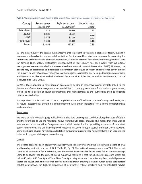
Ocean Health Index - <strong>Kenya</strong> <strong>2018</strong> 22<br />
Table 9. Mangrove extent in each County in 1992 and 2014 and county status scores as the ration of the two covers<br />
Reference cover<br />
County Recent cover<br />
County status<br />
(2014) km 2 (1992) km 2<br />
score<br />
Mombasa 7.15 30.80 0.23<br />
Kwale 89.00 96.72 0.92<br />
Kilifi 54.78 81.19<br />
0.67<br />
Tana River 11.31 61.60<br />
0.18<br />
Lamu 314.52 367.87 0.85<br />
In Tana River County, the remaining mangrove area is present in two small pockets of forest, making it<br />
even more vulnerable to complete deforestation. Declines are likely due to unsustainable harvesting for<br />
timber and other materials, charcoal production, as well as clearing for conversion into agricultural land<br />
for farming (GoK, 2017). Historically, management in this county has been weak, with no official<br />
management areas established in the coastal and marine environment (Baker et al., 2015). However, the<br />
decline may be biased due to differences in estimation techniques of recent and reference cover, time of<br />
the survey, misclassification of mangroves with mangrove-associated species e.g. Barringtonia racemosa<br />
and Thespasia sp. that exist as thick shrubs on the water side of the river as well as Sueda monoica on the<br />
landward side (GoK, 2017).<br />
In 2014, there appears to have been an accelerated decline in mangrove cover, possibly linked to the<br />
devolution of resource management responsibilities to county governments from national government,<br />
which led to a period of lower enforcement and management as the authorities tried to organize<br />
themselves and adapt.<br />
It is important to note that cover is not a complete measure of health and status of mangrove forests, and<br />
in future assessments should be complemented with other indicators for a more comprehensive<br />
understanding.<br />
Seagrasses<br />
We were unable to obtain geographically extensive data on seagrass condition along the coast of <strong>Kenya</strong>,<br />
and therefore had to use the results for <strong>Kenya</strong> from the OHI global analysis. This meant that there was no<br />
inter-county score variation. Seagrasses are a vital marine habitat, providing a variety of important<br />
ecosystem services and are likely highly threatened in <strong>Kenya</strong> through coastal and near-shore activities.<br />
Some site based studies have been undertaken through various projects, however there is an urgent need<br />
to invest in large-scale long-term monitoring.<br />
Overall<br />
The overall score for each county varies greatly with Tana River scoring the lowest with a score of 44.5<br />
and Lamu highest with a score of 92.4 (Table 10, Fig. 6). The national average score was 73.6. The recent<br />
trend in all counties is for a decrease, and the model estimates the future state for all counties except<br />
Lamu to be lower than the current status. A positive message is that for all counties pressure scores are<br />
below 40, with Kilifi County and Tana River County scoring worst and Lamu County best, and all pressure<br />
scores are lower than the resilience scores. Kilifi has prawn trawling activities which cause soft-bottom<br />
habitat destruction, the highest proportion of destructive fishing practices and the intertidal habitat


