


Create successful ePaper yourself
Turn your PDF publications into a flip-book with our unique Google optimized e-Paper software.
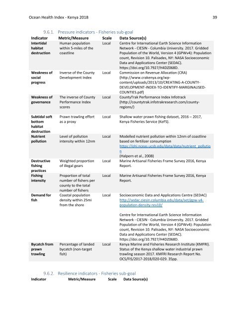
Ocean Health Index - <strong>Kenya</strong> <strong>2018</strong> 39<br />
9.6.1. Pressure indicators - Fisheries sub-goal<br />
Indicator Metric/Measure Scale Data Source(s)<br />
Intertidal<br />
habitat<br />
destruction<br />
Human population<br />
within 5-miles of the<br />
coastline<br />
Local Centre for International Earth Science Information<br />
Network - CIESIN - Columbia University. 2017. Gridded<br />
Population of the World, Version 4 (GPWv4): Population<br />
count, Revision 10. Palisades, NY: NASA Socioeconomic<br />
Data and Applications Center (SEDAC).<br />
Weakness of<br />
social<br />
progress<br />
Weakness of<br />
governance<br />
Inverse of the County<br />
Development Index<br />
The inverse of County<br />
Performance Index<br />
scores<br />
Local<br />
Local<br />
https://doi.org/10.7927/H4DZ068D.<br />
Commission on Revenue Allocation (CRA)<br />
(http://www.crakenya.org/wp-<br />
content/uploads/2013/10/CREATING-A-COUNTY-<br />
DEVELOPMENT-INDEX-TO-IDENTIFY-MARGINALISED-<br />
COUNTIES.pdf)<br />
CountyTrak Performance Index Infotrack<br />
(http://countytrak.infotrakresearch.com/countyregions/)<br />
Subtidal soft<br />
bottom<br />
habitat<br />
destruction<br />
Nutrient<br />
pollution<br />
Destructive<br />
fishing<br />
practices<br />
Fishing<br />
intensity<br />
Demand for<br />
fish<br />
Prawn trawling effort<br />
as a proxy<br />
Level of pollution<br />
intensity within 12nm<br />
Weighted proportion<br />
of illegal gears<br />
Proportion of total<br />
number of fishers per<br />
county to the total<br />
number of fishers<br />
Coastal population<br />
density within 25mi<br />
from the shore<br />
Local Shallow water prawn fishing dataset, 2016 – 2017,<br />
<strong>Kenya</strong> Fisheries Service (KeFS).<br />
Local<br />
Local<br />
Local<br />
Local<br />
Modelled nutrient pollution within 12nm of coastline<br />
based on fertilizer consumption<br />
https://ohi.nceas.ucsb.edu/data/data/nutrient_pollutio<br />
n<br />
(Halpern et al., 2008)<br />
Marine Artisanal Fisheries Frame Survey 2016, <strong>Kenya</strong><br />
<strong>Report</strong>.<br />
Marine Artisanal Fisheries Frame Survey 2016, <strong>Kenya</strong><br />
<strong>Report</strong>.<br />
Socioeconomic Data and Applications Centre (SEDAC)<br />
http://sedac.ciesin.columbia.edu/data/set/gpw-v4-<br />
population-density-rev10/<br />
Bycatch from<br />
prawn<br />
trawling<br />
Percentage of landed<br />
bycatch (non-target<br />
fish)<br />
Local<br />
Centre for International Earth Science Information<br />
Network - CIESIN - Columbia University. 2017. Gridded<br />
Population of the World, Version 4 (GPWv4): Population<br />
count, Revision 10. Palisades, NY: NASA Socioeconomic<br />
Data and Applications Center (SEDAC).<br />
https://doi.org/10.7927/H4DZ068D.<br />
<strong>Kenya</strong> Marine and Fisheries Research Institute (KMFRI).<br />
Status of the <strong>Kenya</strong> shallow water industrial prawn<br />
trawling season 2017. KMFRI Research <strong>Report</strong> No.<br />
OCS/FIS/2017-<strong>2018</strong>/020-029. 35pp.<br />
9.6.2. Resilience indicators - Fisheries sub-goal<br />
Indicator Metric/Measure Scale Data Source(s)


