You also want an ePaper? Increase the reach of your titles
YUMPU automatically turns print PDFs into web optimized ePapers that Google loves.
Ocean Health Index - <strong>Kenya</strong> <strong>2018</strong> 1<br />
1. <strong>Kenya</strong> OHI - Summary for Decision-Makers<br />
The Ocean Health Index (OHI) scientifically<br />
combines key biological, physical, economic,<br />
cultural and social data to understand the health of<br />
a country's ocean resources. It reflects how well<br />
countries optimize potential ocean benefits and<br />
services in a sustainable way relative to a target, on<br />
a scale of 0 to 100. This <strong>Kenya</strong> OHI assessment was<br />
conducted as a participatory process involving<br />
government institutions and stakeholders, hosted<br />
nationally by the National Environmental<br />
Management Authority (NEMA) and <strong>Kenya</strong> Marine<br />
and Fisheries Research Institute (KMFRI), with<br />
technical coordination by CORDIO East Africa,<br />
Conservation International and the National Center<br />
for Ecological Analysis and Synthesis (NCEAS, USA).<br />
1.1. Why now?<br />
<strong>Kenya</strong>'s use of ocean resources is set to expand; fisheries, tourism and shipping are key national sectors<br />
dependent on the ocean, County governments have new lead responsibilities through devolution, and a<br />
new Blue Economy drive is a top national development priority. This OHI analysis can help to align actors<br />
from diverse sectors and across scales, to ensure sustainable use of the ocean and future prosperity.<br />
1.2. Tailoring the OHI to <strong>Kenya</strong>'s needs and priorities<br />
Stakeholders ranked the goals, selecting the top two as priorities<br />
for analysis: Food provision (by fisheries) and Biodiversity (coastal<br />
marine habitats).<br />
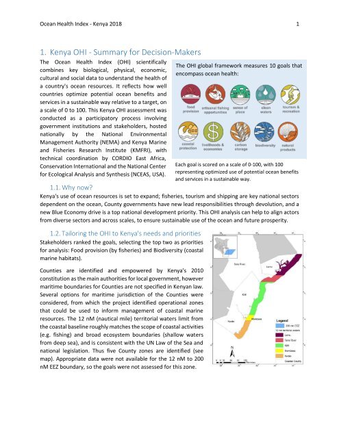
Counties are identified and empowered by <strong>Kenya</strong>'s 2010<br />
constitution as the main authorities for local government, however<br />
maritime boundaries for Counties are not specified in <strong>Kenya</strong>n law.<br />
Several options for maritime jurisdiction of the Counties were<br />
considered, from which the project identified operational zones<br />
that could be used to inform management of coastal marine<br />
resources. The 12 nM (nautical mile) territorial waters limit from<br />
the coastal baseline roughly matches the scope of coastal activities<br />
(e.g. fishing) and broad ecosystem boundaries (shallow waters<br />
from deep sea), and is consistent with the UN Law of the Sea and<br />
national legislation. Thus five County zones are identified (see<br />
map). Appropriate data were not available for the 12 nM to 200<br />
nM EEZ boundary, so the goals were not assessed for this zone.<br />
The OHI global framework measures 10 goals that<br />
encompass ocean health:<br />
Each goal is scored on a scale of 0-100, with 100<br />
representing optimized use of potential ocean benefits<br />
and services in a sustainable way.


