appendix a - National Grid
appendix a - National Grid
appendix a - National Grid

Create successful ePaper yourself
Turn your PDF publications into a flip-book with our unique Google optimized e-Paper software.
TEP on behalf of <strong>National</strong> <strong>Grid</strong> 11 of 21<br />
King’s Lynn 400kV Connection<br />
110488-FRA-R1(1)<br />
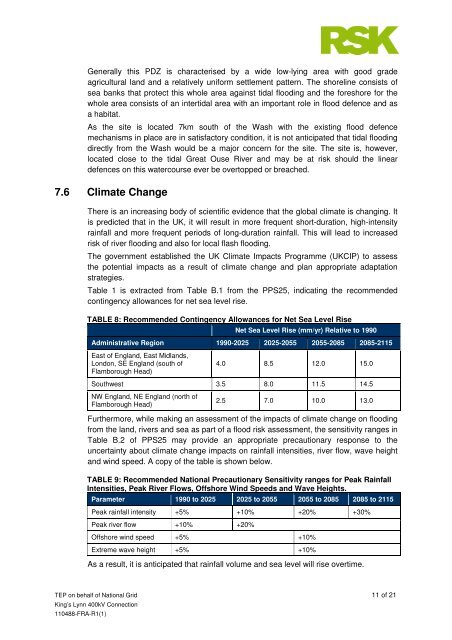
Generally this PDZ is characterised by a wide low-lying area with good grade<br />
agricultural land and a relatively uniform settlement pattern. The shoreline consists of<br />
sea banks that protect this whole area against tidal flooding and the foreshore for the<br />
whole area consists of an intertidal area with an important role in flood defence and as<br />
a habitat.<br />
As the site is located 7km south of the Wash with the existing flood defence<br />
mechanisms in place are in satisfactory condition, it is not anticipated that tidal flooding<br />
directly from the Wash would be a major concern for the site. The site is, however,<br />
located close to the tidal Great Ouse River and may be at risk should the linear<br />
defences on this watercourse ever be overtopped or breached.<br />
7.6 Climate Change<br />
There is an increasing body of scientific evidence that the global climate is changing. It<br />
is predicted that in the UK, it will result in more frequent short-duration, high-intensity<br />
rainfall and more frequent periods of long-duration rainfall. This will lead to increased<br />
risk of river flooding and also for local flash flooding.<br />
The government established the UK Climate Impacts Programme (UKCIP) to assess<br />
the potential impacts as a result of climate change and plan appropriate adaptation<br />
strategies.<br />
Table 1 is extracted from Table B.1 from the PPS25, indicating the recommended<br />
contingency allowances for net sea level rise.<br />
TABLE 8: Recommended Contingency Allowances for Net Sea Level Rise<br />
Net Sea Level Rise (mm/yr) Relative to 1990<br />
Administrative Region 1990-2025 2025-2055 2055-2085 2085-2115<br />
East of England, East Midlands,<br />
London, SE England (south of<br />
Flamborough Head)<br />
4.0 8.5 12.0 15.0<br />
Southwest 3.5 8.0 11.5 14.5<br />
NW England, NE England (north of<br />
Flamborough Head)<br />
2.5 7.0 10.0 13.0<br />
Furthermore, while making an assessment of the impacts of climate change on flooding<br />
from the land, rivers and sea as part of a flood risk assessment, the sensitivity ranges in<br />
Table B.2 of PPS25 may provide an appropriate precautionary response to the<br />
uncertainty about climate change impacts on rainfall intensities, river flow, wave height<br />
and wind speed. A copy of the table is shown below.<br />
TABLE 9: Recommended <strong>National</strong> Precautionary Sensitivity ranges for Peak Rainfall<br />
Intensities, Peak River Flows, Offshore Wind Speeds and Wave Heights.<br />
Parameter 1990 to 2025 2025 to 2055 2055 to 2085 2085 to 2115<br />
Peak rainfall intensity +5% +10% +20% +30%<br />
Peak river flow +10% +20%<br />
Offshore wind speed +5% +10%<br />
Extreme wave height +5% +10%<br />
As a result, it is anticipated that rainfall volume and sea level will rise overtime.