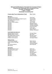
appendix a - National Grid
appendix a - National Grid
appendix a - National Grid

Create successful ePaper yourself
Turn your PDF publications into a flip-book with our unique Google optimized e-Paper software.
"This document has been prepared by Faber Maunsell Limited ("FM") for the sole use of our Client (the "Client") and in accordance with generally accepted consultancy principles, the budget fees and the terms of reference agreed between FM and the Client.<br />
Any information provided by third parties and referred to herein has not been checked or verified by FM, unless otherwise expressly stated in the document. No third party may rely upon this document without the prior and express written agreement of FM"<br />
(<br />
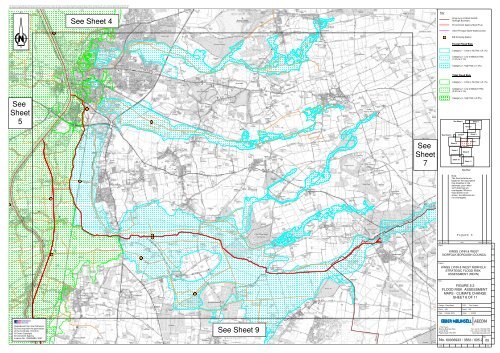
See<br />
Sheet<br />
5<br />
Reproduced from the Ordnance<br />
Survey map with the permission<br />
of the Controller, H.M.S.O<br />
© Crown Copyright<br />
Environment Agency<br />
Licence No. 100026380, 2007<br />
(((((((<br />
(<br />
(((((((((((((((((<br />
See Sheet 4<br />
(((((((((((((<br />
(<br />
(<br />
(<br />
(((((((((((((<br />
(((((((((((((<br />
(((((((((((((<br />
See Sheet 9<br />
See<br />
Sheet<br />
7<br />
Key<br />
Title:<br />
Design:<br />
Chk'd:<br />
Date:<br />
cm<br />
((((((((((((<br />
See Sheet 4<br />
IDB Pumping Station<br />
See Sheet 1<br />
Sheet 5<br />
Clare Marsh<br />
Sheet 8<br />
Sheet 10<br />
Sheet 4<br />
Sheet 2<br />
Sheet 6<br />
Sheet 9<br />
Sheet 11<br />
Key Plan<br />
Sheet 1<br />
Sheet 3<br />
Sheet 7<br />
Rev Date<br />
Detail<br />
Made Chk'd App'd<br />
Client:<br />
Project:<br />
KINGS LYNN & WEST NORFOLK<br />
STRATEGIC FLOOD RISK<br />
ASSESSMENT (REVN)<br />
1 The Forum,<br />
Minerva Business Park,<br />
Lynch Wood<br />
Peterborough, PE2 6FT<br />
No.<br />
KINGS LYNN & WEST<br />
NORFOLK BOROUGH COUNCIL<br />
BB<br />
October 2009<br />
Kings Lynn & West Norfolk<br />
Borough Boundary<br />
Environment Agency Main River<br />
Other Principal Open Watercourses<br />
Fluvial Flood Risk<br />
Category 1 - Little or No Risk (1.0%)<br />
Tidal Flood Risk<br />
Category 1 - Little or No Risk (0.5%)<br />
Note:<br />
The flood extents are<br />
based on the assumption<br />
that breaches in the<br />
defences occur when<br />
'soft' defences are<br />
overtopped. Where a<br />
flood extent is not<br />
shown, the defences are<br />
not overtopped.<br />
FIGURE 5.2<br />
FLOOD RISK ASSESSMENT<br />
MAPS - CLIMATE CHANGE<br />
SHEET 6 OF 11<br />
CAD:<br />
App'd:<br />
Scale:<br />
Tom Hudson<br />
BB<br />
1 : 25 000<br />
Tel: +44 (0) 1733 391 456<br />
Fax: +44 (0) 1733 391 139<br />
www.fabermaunsell.com<br />
60036933 / 3563 / 005.2<br />
Rev:<br />
05<br />
A1<br />
cm