appendix a - National Grid
appendix a - National Grid
appendix a - National Grid

Create successful ePaper yourself
Turn your PDF publications into a flip-book with our unique Google optimized e-Paper software.
Environment Agency - What's in your backyard?<br />
Enter a postcode or place name:<br />
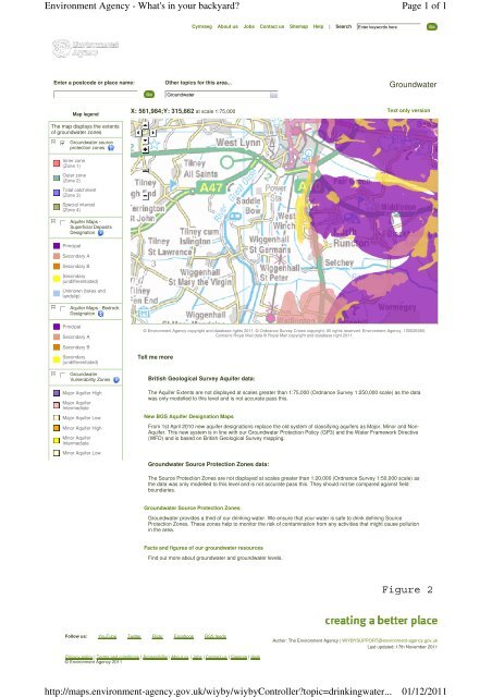
Map legend<br />
The map displays the extents<br />
of groundwater zones<br />
gfedcb<br />
Groundwater source<br />
protection zones<br />
Inner zone<br />
(Zone 1)<br />
Outer zone<br />
(Zone 2)<br />
Total catchment<br />
(Zone 3)<br />
Special interest<br />
(Zone 4)<br />
gfedc<br />
Aquifer Maps -<br />
Superficial Deposits<br />
Designation<br />
Principal<br />
Secondary A<br />
Secondary B<br />
Secondary<br />
(undifferentiated)<br />
Unknown (lakes and<br />
landslip)<br />
gfedc<br />
Aquifer Maps - Bedrock<br />
Designation<br />
Principal<br />
Secondary A<br />
Secondary B<br />
Secondary<br />
(undifferentiated)<br />
gfedc Groundwater<br />
Vulnerability Zones<br />
Major Aquifer High<br />
Major Aquifer<br />
Intermediate<br />
Major Aquifer Low<br />
Minor Aquifer High<br />
Minor Aquifer<br />
Intermediate<br />
Minor Aquifer Low<br />
Cymraeg About us Jobs Contact us Sitemap Help | Search Enter keywords here<br />
Other topics for this area...<br />
Groundwater<br />
X: 561,984;Y: 315,662 at scale 1:75,000<br />
Groundwater<br />
Text only version<br />
© Environment Agency copyright and database rights 2011. © Ordnance Survey Crown copyright. All rights reserved. Environment Agency, 100026380.<br />
Contains Royal Mail data © Royal Mail copyright and database right 2011.<br />
Tell me more<br />
British Geological Survey Aquifer data:<br />
Follow us: YouTube Twitter Flickr Facebook RSS feeds<br />
The Aquifer Extents are not displayed at scales greater than 1:75,000 (Ordnance Survey 1:250,000 scale) as the data<br />
was only modelled to this level and is not accurate pass this.<br />
New BGS Aquifer Designation Maps<br />
From 1st April 2010 new aquifer designations replace the old system of classifying aquifers as Major, Minor and Non-<br />
Aquifer. This new system is in line with our Groundwater Protection Policy (GP3) and the Water Framework Directive<br />
(WFD) and is based on British Geological Survey mapping.<br />
Groundwater Source Protection Zones data:<br />
The Source Protection Zones are not displayed at scales greater than 1:20,000 (Ordnance Survey 1:50,000 scale) as<br />
the data was only modelled to this level and is not accurate pass this. They should not be compared against field<br />
boundaries.<br />
Groundwater Source Protection Zones<br />
Groundwater provides a third of our drinking water. We ensure that your water is safe to drink defining Source<br />
Protection Zones. These zones help to monitor the risk of contamination from any activities that might cause pollution<br />
in the area.<br />
Facts and figures of our groundwater resources<br />
Find out more about groundwater and groundwater levels.<br />
Privacy policy | Terms and conditions | Accessibility | About us | Jobs | Contact us | Sitemap | Help<br />
© Environment Agency 2011<br />
Page 1 of 1<br />
Author: The Environment Agency | WIYBYSUPPORT@environment-agency.gov.uk<br />
Last updated: 17th November 2011<br />
http://maps.environment-agency.gov.uk/wiyby/wiybyController?topic=drinkingwater...<br />
01/12/2011