Africa Surveyors May-June issue 2021
Africa Surveyors is Africa’s premier source of Surveying, Mapping and Geospatial news and an envoy of surveying products/service for the Construction, Maritime, Onshore & Offshore energy and exploration, Engineering, Oil and Gas, Agricultural and Mining sectors on new solution based trends and technology for the African market.
Africa Surveyors is Africa’s premier source of Surveying, Mapping and Geospatial news and an envoy of surveying products/service for the Construction, Maritime, Onshore & Offshore energy and exploration, Engineering, Oil and Gas, Agricultural and Mining sectors on new solution based trends and technology for the African market.

You also want an ePaper? Increase the reach of your titles
YUMPU automatically turns print PDFs into web optimized ePapers that Google loves.
INNOVATION<br />
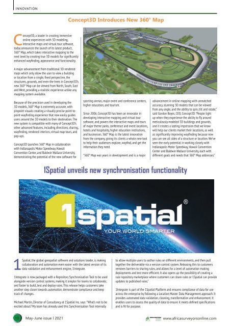
Concept3D Introduces New 360° Map<br />
Concept3D, a leader in creating immersive<br />
online experiences with 3D modeling,<br />
interactive maps and virtual tour software,<br />
today announces the launch of its latest product,<br />
360° Map, which takes interactive mapping to the<br />
next level by creating true 3D models for significantly<br />
enhanced wayfinding, appearance and functionality.<br />
A major advancement from traditional 3D rendered<br />
maps which only allow the user to view a building<br />
or location from a single, fixed perspective, the<br />
structures, grounds, and even the trees in Concept3D’s<br />
new 360° Map can be viewed from North, South, East<br />
and West, providing a realistic experience unlike any<br />
mapping system available.<br />
Because of the precision used in developing the<br />
3D models, 360° Map is extremely accurate, with<br />
pinpoint visuals creating a visually precise point-topoint<br />
wayfinding experience that now easily guides<br />
users around the 3D models to their destination. The<br />
new system is compatible with many of Concept3D’s<br />
other advanced features, including directions, sharing,<br />
wayfinding, rendered interiors, virtual map tours, and<br />
pop-ups.<br />
Concept3D launches 360° Map in collaboration<br />
with Indianapolis Motor Speedway, Hawaii<br />
Convention Center, and Baldwin Wallace University,<br />
demonstrating the potential of the new software for<br />
sporting arenas, major event and conference centers,<br />
higher education, and tourism.<br />
Since 2006, Concept3D has been an innovator in<br />
developing interactive mapping and virtual tour<br />
software, and powers the interactive maps and tours<br />
of major theme parks, conference and event locations,<br />
hotels and hospitality, higher education institutions,<br />
and businesses. 360° Map is the latest innovation<br />
from the company, giving its clients a whole new tool<br />
to help their audiences explore, wayfind, and get the<br />
information they need.<br />
“360° Map was years in development and is a major<br />
advancement in online mapping with unmatched<br />
accuracy, stunning 3D models that can be viewed<br />
from any angle, and the ability to spin, tilt and rotate,”<br />
said Gordon Boyes, CEO, Concept3D. “People light<br />
up when they experience the ability to fly around<br />
meticulously modeled 3D buildings and grounds,<br />
and it creates a lasting impression that we know<br />
will help our clients market their locations, as well<br />
as significantly improving wayfinding because now<br />
you can see all sides of a structure or location. We’ve<br />
seen the early potential in working closely with<br />
Indianapolis Motor Speedway, Hawaii Convention<br />
Center and Baldwin Wallace University, each with<br />
different goals and needs that 360° Map addresses.”<br />
1Spatial unveils new synchronisation functionality<br />
1Spatial, the global geospatial software and solutions leader, is making<br />
collaboration and automation even easier with the latest version of its<br />
data validation and enhancement engine, 1Integrate.<br />
1Integrate is now packaged with a Repository Synchronisation Tool to be used<br />
alongside version control systems, making it simpler for teams to collaborate;<br />
and faster to build, test and deploy rules. This release helps customers take<br />
another step closer towards automation, demonstrate compliance and keep<br />
track of changes.<br />
Michael Martin, Director of Consultancy at 1Spatial Inc. says: “What’s not to be<br />
excited about? My team has already used this Synchronisation Tool internally<br />
to allow multiple users to author rules on different environments, and then pull<br />
together the deliverable via a version control system. Releasing this to customers<br />
removes barriers to sharing rules, and allows for a level of automation making<br />
deployments and test more efficient. It also opens up the possibility of creating a<br />
rule repository marketplace where customers can share rules or 1Spatial can provide<br />
updates to published rules.”<br />
1Integrate is part of the 1Spatial Platform and ensures compliance of data for use<br />
across the enterprise by following a Location Master Data Management approach. It<br />
provides automated data validation, cleaning, transformation and enhancement. It<br />
enables users to assess the quality of data to ensure it meets defined specifications<br />
and is fit for purpose.<br />
10 <strong>May</strong>-<strong>June</strong> <strong>issue</strong> l <strong>2021</strong> www.africasurveyorsonline.com