Africa Surveyors May-June issue 2021
Africa Surveyors is Africa’s premier source of Surveying, Mapping and Geospatial news and an envoy of surveying products/service for the Construction, Maritime, Onshore & Offshore energy and exploration, Engineering, Oil and Gas, Agricultural and Mining sectors on new solution based trends and technology for the African market.
Africa Surveyors is Africa’s premier source of Surveying, Mapping and Geospatial news and an envoy of surveying products/service for the Construction, Maritime, Onshore & Offshore energy and exploration, Engineering, Oil and Gas, Agricultural and Mining sectors on new solution based trends and technology for the African market.

You also want an ePaper? Increase the reach of your titles
YUMPU automatically turns print PDFs into web optimized ePapers that Google loves.
GEOGRAPHICS<br />
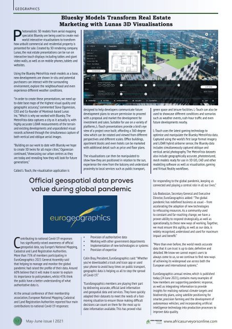
Photorealistic 3D models from aerial mapping<br />
specialist Bluesky are being used to create realworld<br />
interactive visualisations to transform<br />
how unbuilt commercial and residential property is<br />
presented for sale. Created by 3D rendering company<br />
Lunas, the real estate presentations can be run on<br />
interactive touch displays including tables and giant<br />
video walls, as well as on mobile phones, tablets and<br />
websites.<br />
Using the Bluesky MetroVista mesh models as a base,<br />
new developments are shown in-situ and potential<br />
purchasers can interact with the surrounding<br />
environment, explore the neighbourhood and even<br />
experience different weather conditions.<br />
Bluesky Models Transform Real Estate<br />
Marketing with Lunas 3D Visualisations<br />
“In order to create these presentations, we need upto-date<br />
base maps of the highest visual quality and<br />
geographic accuracy,” commented Slava Oganesian,<br />
CEO and Co-founder of Montreal-based Lunas<br />
Inc. “Which is why we worked with Bluesky. The<br />
MetroVista data captures a city as it actually is, with<br />
highly accurate LiDAR measurements of the terrain<br />
and existing developments and unparalleled visual<br />
records achieved through the simultaneous capture of<br />
both vertical and oblique aerial images.<br />
“Building on our work to date with Bluesky we hope<br />
to create 3D twins for all major cities,” Oganesian<br />
continued, “showcasing our urban centres as they<br />
are today and revealing how they will look for future<br />
generations.”<br />
Called L-Touch, the visualisation application is<br />
designed to help developers communicate future<br />
development plans to secure permission to proceed<br />
with a proposal and market the development for<br />
investment and sales. Suitable for use on a variety of<br />
platforms, L-Touch presentations provide a bird’s eye<br />
view of a project once built; affording a 360-degree<br />
view which can be rotated and viewed from different<br />
perspectives and different scales. Office buildings,<br />
apartment blocks and even hotels can be marketed<br />
with additional detail such as price and floor plans.<br />
The visualisations can then be manipulated to<br />
show how they are positioned in relation to the sun,<br />
experience the view from the balcony and understand<br />
proximity to local services such as public transport,<br />
Official geospatial data proves<br />
value during global pandemic<br />
Contributing to national Covid-19 responses<br />
has significantly raised awareness of official<br />
geospatial data, say Europe’s National Mapping,<br />
Cadastral and Land Registration Authorities.<br />
More than 75% of members participating in<br />
EuroGeographics <strong>2021</strong> General Assembly said<br />
that helping to manage and monitor the global<br />
pandemic had raised the profile of their data. Around<br />
60% believe that it will make it easier to explain<br />
its importance to policymakers, whilst 43% think<br />
the public have a better understanding of what<br />
authoritative data is.<br />
At the annual conference of their membership<br />
association, European National Mapping, Cadastral<br />
and Land Registration Authorities reported four main<br />
contributions to national Covid-19 responses:<br />
• Provision of authoritative data<br />
• Working with other government departments<br />
• Implementation of new technologies or systems<br />
• Provision of expertise<br />
Colin Bray, President, EuroGeographics said: “Whether<br />
you’ve downloaded a track and trace app or used<br />
your phone to avoid busy times on public transport,<br />
geographic data is helping us all to stop the spread<br />
of Covid-19.”<br />
“EuroGeographics members are playing their part<br />
by delivering accurate, official land information<br />
and geospatial data and services. They have quickly<br />
adapted their datasets to meet the needs of a fastmoving<br />
situation to ensure those making difficult<br />
decisions can count on them for the most up to<br />
date information available. This has proved vital<br />
green space and leisure facilities. L-Touch can also be<br />
used to showcase different conditions and scenarios<br />
such as weather events, rush-hour traffic and even<br />
future developments nearby.<br />
L-Touch uses the latest gaming technology to<br />
optimise and manipulate the Bluesky MetroVista data.<br />
Captured using the world’s first large format imagery<br />
and LiDAR hybrid airborne sensor, the Bluesky data<br />
includes simultaneously captured oblique and<br />
vertical aerial photography. The MetroVista datasets<br />
also include geographically accurate, phototextured,<br />
mesh models ready for use in 3D GIS, CAD and other<br />
modelling software as well as visualisation, gaming<br />
and Virtual Reality workflows.<br />
for responding to the global pandemic, keeping us<br />
connected and playing a central role in all our lives.”<br />
Léa Bodossian, Secretary General and Executive<br />
Director, EuroGeographics added: “The global<br />
pandemic has redefined business as usual – from<br />
accelerating the adoption of new technologies<br />
to refocusing resources. As a community used<br />
to constant and far-reaching change, we have a<br />
proven ability to respond strategically, as well as<br />
operationally, to these new ways of working. Together,<br />
we must ensure this agility, as well as our data, is<br />
widely recognised, understood and used for maximum<br />
impact and benefit.”<br />
“More than ever before, the world needs accurate<br />
data that it can trust is up to date, definitive and<br />
detailed. We know we cannot expect users to<br />
always come to us, so we continue to find new ways<br />
of achieving its widespread use across both the<br />
European and international systems.”<br />
EuroGeographics annual review, which is published<br />
today (24 <strong>June</strong> <strong>2021</strong>), contains many examples of<br />
how members are supporting pandemic response,<br />
as well as integrating information to provide<br />
insights for realising national climate targets and<br />
biodiversity plans, using satellite positioning for<br />
smarter, precision farming and the development of<br />
autonomous vehicles; and incorporating artificial<br />
intelligence technology into production processes to<br />
improve data quality.<br />
12 <strong>May</strong>-<strong>June</strong> <strong>issue</strong> l <strong>2021</strong> www.africasurveyorsonline.com