final evaluation report akk_iges_final.pdf - IGES EnviroScope
final evaluation report akk_iges_final.pdf - IGES EnviroScope
final evaluation report akk_iges_final.pdf - IGES EnviroScope

Create successful ePaper yourself
Turn your PDF publications into a flip-book with our unique Google optimized e-Paper software.
APFED Project Final Evaluation Report 2011<br />
• Flood risk mitigation works such as homestead raising.<br />
• Aman paddy seeds distribution for flood tolerant crops production.<br />
• Demonstration of floating garden for vegetable cultivation during floods.<br />
3. Project location<br />
Geography:<br />
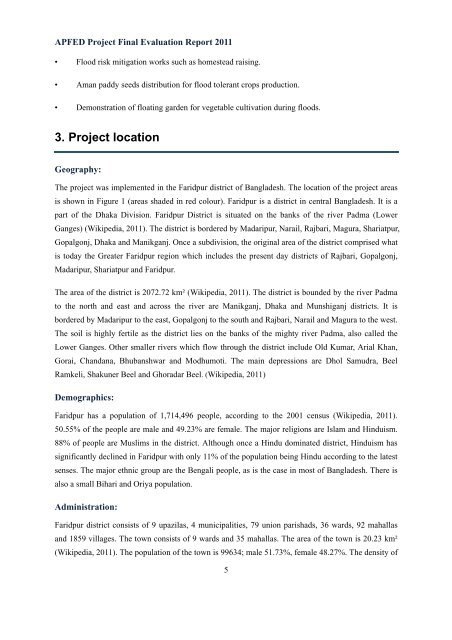
The project was implemented in the Faridpur district of Bangladesh. The location of the project areas<br />
is shown in Figure 1 (areas shaded in red colour). Faridpur is a district in central Bangladesh. It is a<br />
part of the Dhaka Division. Faridpur District is situated on the banks of the river Padma (Lower<br />
Ganges) (Wikipedia, 2011). The district is bordered by Madaripur, Narail, Rajbari, Magura, Shariatpur,<br />
Gopalgonj, Dhaka and Manikganj. Once a subdivision, the original area of the district comprised what<br />
is today the Greater Faridpur region which includes the present day districts of Rajbari, Gopalgonj,<br />
Madaripur, Shariatpur and Faridpur.<br />
The area of the district is 2072.72 km² (Wikipedia, 2011). The district is bounded by the river Padma<br />
to the north and east and across the river are Manikganj, Dhaka and Munshiganj districts. It is<br />
bordered by Madaripur to the east, Gopalgonj to the south and Rajbari, Narail and Magura to the west.<br />
The soil is highly fertile as the district lies on the banks of the mighty river Padma, also called the<br />
Lower Ganges. Other smaller rivers which flow through the district include Old Kumar, Arial Khan,<br />
Gorai, Chandana, Bhubanshwar and Modhumoti. The main depressions are Dhol Samudra, Beel<br />
Ramkeli, Shakuner Beel and Ghoradar Beel. (Wikipedia, 2011)<br />
Demographics:<br />
Faridpur has a population of 1,714,496 people, according to the 2001 census (Wikipedia, 2011).<br />
50.55% of the people are male and 49.23% are female. The major religions are Islam and Hinduism.<br />
88% of people are Muslims in the district. Although once a Hindu dominated district, Hinduism has<br />
significantly declined in Faridpur with only 11% of the population being Hindu according to the latest<br />
senses. The major ethnic group are the Bengali people, as is the case in most of Bangladesh. There is<br />
also a small Bihari and Oriya population.<br />
Administration:<br />
Faridpur district consists of 9 upazilas, 4 municipalities, 79 union parishads, 36 wards, 92 mahallas<br />
and 1859 villages. The town consists of 9 wards and 35 mahallas. The area of the town is 20.23 km²<br />
(Wikipedia, 2011). The population of the town is 99634; male 51.73%, female 48.27%. The density of<br />
5