

Designated Airspace Handbook - Nav Canada
Designated Airspace Handbook - Nav Canada
Designated Airspace Handbook - Nav Canada

Create successful ePaper yourself
Turn your PDF publications into a flip-book with our unique Google optimized e-Paper software.
© 2013 Her Majesty the Queen in Right of <strong>Canada</strong> Source of Canadian <strong>Airspace</strong> Data © 2013 Transport <strong>Canada</strong><br />
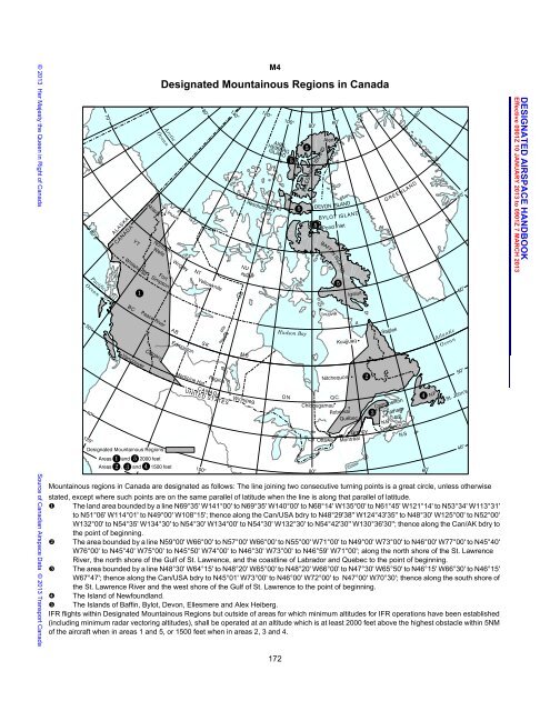
M4<br />
<strong>Designated</strong> Mountainous Regions in <strong>Canada</strong><br />
Mountainous regions in <strong>Canada</strong> are designated as follows: The line joining two consecutive turning points is a great circle, unless otherwise<br />
stated, except where such points are on the same parallel of latitude when the line is along that parallel of latitude.<br />
� The land area bounded by a line N69°35' W141°00' to N69°35' W140°00' to N68°14' W135°00' to N61°45' W121°14' to N53°34' W113°31'<br />
to N51°06' W114°01' to N49°00' W108°15'; thence along the Can/USA bdry to N48°29'38'' W124°43'35'' to N48°30' W125°00' to N52°00'<br />
W132°00' to N54°35' W134°30' to N54°30' W134°00' to N54°30' W132°30' to N54°42'30'' W130°36'30''; thence along the Can/AK bdry to<br />
the point of beginning.<br />
� The area bounded by a line N59°00' W66°00' to N57°00' W66°00' to N55°00' W71°00' to N49°00' W73°00' to N46°00' W77°00' to N45°40'<br />
W76°00' to N45°40' W75°00' to N45°50' W74°00' to N46°30' W73°00' to N46°59' W71°00'; along the north shore of the St. Lawrence<br />
River, the north shore of the Gulf of St. Lawrence, and the coastline of Labrador and Quebec to the point of beginning.<br />
� The area bounded by a line N48°30' W64°15' to N48°20' W65°00' to N48°20' W66°00' to N47°30' W65°50' to N46°15' W66°30' to N46°15'<br />
W67°47'; thence along the Can/USA bdry to N45°01' W73°00' to N46°00' W72°00' to N47°00' W70°30'; thence along the south shore of<br />
the St. Lawrence River and the west shore of the Gulf of St. Lawrence to the point of beginning.<br />
� The Island of Newfoundland.<br />
� The Islands of Baffin, Bylot, Devon, Ellesmere and Alex Heiberg.<br />
IFR flights within <strong>Designated</strong> Mountainous Regions but outside of areas for which minimum altitudes for IFR operations have been established<br />
(including minimum radar vectoring altitudes), shall be operated at an altitude which is at least 2000 feet above the highest obstacle within 5NM<br />
of the aircraft when in areas 1 and 5, or 1500 feet when in areas 2, 3 and 4.<br />
172<br />
DAH December 5, 2012 10:57 am<br />
DESIGNATED AIRSPACE HANDBOOK<br />
Effective 0901Z 10 JANUARY 2013 to 0901Z 7 MARCH 2013


![[ cac ] canadian airport charts - Nav Canada](https://img.yumpu.com/12328212/1/190x252/-cac-canadian-airport-charts-nav-canada.jpg?quality=85)


