

Designated Airspace Handbook - Nav Canada
Designated Airspace Handbook - Nav Canada
Designated Airspace Handbook - Nav Canada

You also want an ePaper? Increase the reach of your titles
YUMPU automatically turns print PDFs into web optimized ePapers that Google loves.
© 2013 Her Majesty the Queen in Right of <strong>Canada</strong> Source of Canadian <strong>Airspace</strong> Data © 2013 Transport <strong>Canada</strong><br />
MONCTON FLIGHT INFORMATION REGION CONTROL ZONES<br />
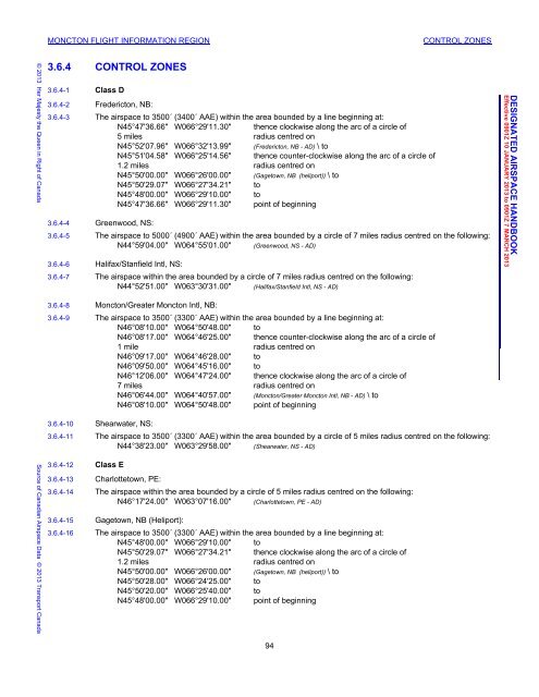
3.6.4 CONTROL ZONES<br />
3.6.4-1 Class D<br />
3.6.4-2 Fredericton, NB:<br />
3.6.4-3 The airspace to 3500´ (3400´ AAE) within the area bounded by a line beginning at:<br />
N45°47'36.66" W066°29'11.30" thence clockwise along the arc of a circle of<br />
5 miles radius centred on<br />
N45°52'07.96" W066°32'13.99" (Fredericton, NB - AD) \ to<br />
N45°51'04.58" W066°25'14.56" thence counter-clockwise along the arc of a circle of<br />
1.2 miles radius centred on<br />
N45°50'00.00" W066°26'00.00" (Gagetown, NB (heliport)) \ to<br />
N45°50'29.07" W066°27'34.21" to<br />
N45°48'00.00" W066°29'10.00" to<br />
N45°47'36.66" W066°29'11.30" point of beginning<br />
3.6.4-4 Greenwood, NS:<br />
3.6.4-5 The airspace to 5000´ (4900´ AAE) within the area bounded by a circle of 7 miles radius centred on the following:<br />
N44°59'04.00" W064°55'01.00" (Greenwood, NS - AD)<br />
3.6.4-6 Halifax/Stanfield Intl, NS:<br />
3.6.4-7 The airspace within the area bounded by a circle of 7 miles radius centred on the following:<br />
N44°52'51.00" W063°30'31.00" (Halifax/Stanfield Intl, NS - AD)<br />
3.6.4-8 Moncton/Greater Moncton Intl, NB:<br />
3.6.4-9 The airspace to 3500´ (3300´ AAE) within the area bounded by a line beginning at:<br />
N46°08'10.00" W064°50'48.00" to<br />
N46°08'17.00" W064°46'25.00" thence counter-clockwise along the arc of a circle of<br />
1 mile radius centred on<br />
N46°09'17.00" W064°46'28.00" to<br />
N46°09'50.00" W064°45'16.00" to<br />
N46°12'06.00" W064°47'24.00" thence clockwise along the arc of a circle of<br />
7 miles radius centred on<br />
N46°06'44.00" W064°40'57.00" (Moncton/Greater Moncton Intl, NB - AD) \ to<br />
N46°08'10.00" W064°50'48.00" point of beginning<br />
3.6.4-10 Shearwater, NS:<br />
3.6.4-11 The airspace to 3500´ (3300´ AAE) within the area bounded by a circle of 5 miles radius centred on the following:<br />
N44°38'23.00" W063°29'58.00" (Shearwater, NS - AD)<br />
3.6.4-12 Class E<br />
3.6.4-13 Charlottetown, PE:<br />
3.6.4-14 The airspace within the area bounded by a circle of 5 miles radius centred on the following:<br />
N46°17'24.00" W063°07'16.00" (Charlottetown, PE - AD)<br />
3.6.4-15 Gagetown, NB (Heliport):<br />
3.6.4-16 The airspace to 3500´ (3300´ AAE) within the area bounded by a line beginning at:<br />
N45°48'00.00" W066°29'10.00" to<br />
N45°50'29.07" W066°27'34.21" thence clockwise along the arc of a circle of<br />
1.2 miles radius centred on<br />
N45°50'00.00" W066°26'00.00" (Gagetown, NB (heliport)) \ to<br />
N45°50'28.00" W066°24'25.00" to<br />
N45°50'20.00" W066°25'40.00" to<br />
N45°48'00.00" W066°29'10.00" point of beginning<br />
94<br />
DAH December 5, 2012 10:57 am<br />
DESIGNATED AIRSPACE HANDBOOK<br />
Effective 0901Z 10 JANUARY 2013 to 0901Z 7 MARCH 2013


![[ cac ] canadian airport charts - Nav Canada](https://img.yumpu.com/12328212/1/190x252/-cac-canadian-airport-charts-nav-canada.jpg?quality=85)


