

Designated Airspace Handbook - Nav Canada
Designated Airspace Handbook - Nav Canada
Designated Airspace Handbook - Nav Canada

You also want an ePaper? Increase the reach of your titles
YUMPU automatically turns print PDFs into web optimized ePapers that Google loves.
© 2013 Her Majesty the Queen in Right of <strong>Canada</strong> Source of Canadian <strong>Airspace</strong> Data © 2013 Transport <strong>Canada</strong><br />
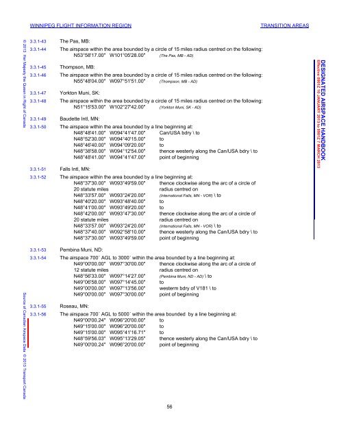
WINNIPEG FLIGHT INFORMATION REGION TRANSITION AREAS<br />
3.3.1-43 The Pas, MB:<br />
3.3.1-44 The airspace within the area bounded by a circle of 15 miles radius centred on the following:<br />
N53°58'17.00" W101°05'28.00" (The Pas, MB - AD)<br />
3.3.1-45 Thompson, MB:<br />
3.3.1-46 The airspace within the area bounded by a circle of 15 miles radius centred on the following:<br />
N55°48'04.00" W097°51'51.00" (Thompson, MB - AD)<br />
3.3.1-47 Yorkton Muni, SK:<br />
3.3.1-48 The airspace within the area bounded by a circle of 15 miles radius centred on the following:<br />
N51°15'53.00" W102°27'42.00" (Yorkton Muni, SK - AD)<br />
3.3.1-49 Baudette Intl, MN:<br />
3.3.1-50 The airspace within the area bounded by a line beginning at:<br />
N48°48'41.00" W094°41'47.00" Can/USA bdry \ to<br />
N48°52'30.00" W094°40'15.00" to<br />
N48°46'40.00" W094°09'20.00" to<br />
N48°38'58.00" W094°12'54.00" thence westerly along the Can/USA bdry \ to<br />
N48°48'41.00" W094°41'47.00" point of beginning<br />
3.3.1-51 Falls Intl, MN:<br />
3.3.1-52 The airspace within the area bounded by a line beginning at:<br />
N48°37'30.00" W093°49'59.00" thence clockwise along the arc of a circle of<br />
20 statute miles radius centred on<br />
N48°33'57.00" W093°24'20.00" (International Falls, MN - VOR) \ to<br />
N48°40'20.00" W093°48'40.00" to<br />
N48°41'00.00" W093°49'20.00" to<br />
N48°42'00.00" W093°47'30.00" thence clockwise along the arc of a circle of<br />
20 statute miles radius centred on<br />
N48°33'57.00" W093°24'20.00" (International Falls, MN - VOR) \ to<br />
N48°37'40.00" W092°58'10.00" thence westerly along the Can/USA bdry \ to<br />
N48°37'30.00" W093°49'59.00" point of beginning<br />
3.3.1-53 Pembina Muni, ND:<br />
3.3.1-54 The airspace 700´ AGL to 3000´ within the area bounded by a line beginning at:<br />
N49°00'00.00" W097°30'00.00" thence clockwise along the arc of a circle of<br />
12 statute miles radius centred on<br />
N48°56'33.00" W097°14'27.00" (Pembina Muni, ND - AD) \ to<br />
N49°06'58.00" W097°14'45.00" to<br />
N49°00'00.00" W097°13'56.00" westerm bdry of V181 \ to<br />
N49°00'00.00" W097°30'00.00" point of beginning<br />
3.3.1-55 Roseau, MN:<br />
3.3.1-56 The airspace 700´ AGL to 5000´ within the area bounded by a line beginning at:<br />
N49°00'00.24" W096°20'00.00" to<br />
N49°15'00.00" W096°20'00.00" to<br />
N49°15'00.00" W095°41'16.71" to<br />
N48°59'56.03" W095°13'29.05" thence westerly along the Can/USA bdry \ to<br />
N49°00'00.24" W096°20'00.00" point of beginning<br />
56<br />
DAH December 5, 2012 10:57 am<br />
DESIGNATED AIRSPACE HANDBOOK<br />
Effective 0901Z 10 JANUARY 2013 to 0901Z 7 MARCH 2013


![[ cac ] canadian airport charts - Nav Canada](https://img.yumpu.com/12328212/1/190x252/-cac-canadian-airport-charts-nav-canada.jpg?quality=85)


