

Designated Airspace Handbook - Nav Canada
Designated Airspace Handbook - Nav Canada
Designated Airspace Handbook - Nav Canada

Create successful ePaper yourself
Turn your PDF publications into a flip-book with our unique Google optimized e-Paper software.
© 2013 Her Majesty the Queen in Right of <strong>Canada</strong> Source of Canadian <strong>Airspace</strong> Data © 2013 Transport <strong>Canada</strong><br />
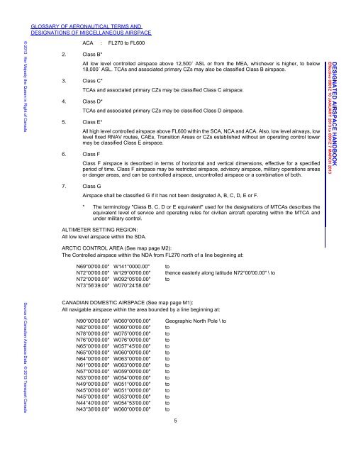
GLOSSARY OF AERONAUTICAL TERMS AND<br />
DESIGNATIONS OF MISCELLANEOUS AIRSPACE<br />
2. Class B*<br />
ACA : FL270 to FL600<br />
All low level controlled airspace above 12,500´ ASL or from the MEA, whichever is higher, to below<br />
18,000´ ASL. TCAs and associated primary CZs may also be classified Class B airspace.<br />
3. Class C*<br />
4. Class D*<br />
5. Class E*<br />
6. Class F<br />
7. Class G<br />
TCAs and associated primary CZs may be classified Class C airspace.<br />
TCAs and associated primary CZs may be classified Class D airspace.<br />
All high level controlled airspace above FL600 within the SCA, NCA and ACA. Also, low level airways, low<br />
level fixed RNAV routes, CAEs, Transition Areas or CZs established without an operating control tower<br />
may be classified Class E airspace.<br />
Class F airspace is described in terms of horizontal and vertical dimensions, effective for a specified<br />
period of time. Class F airspace may be restricted airspace, advisory airspace, military operations areas<br />
or danger areas, and can be controlled airspace, uncontrolled airspace or a combination of both.<br />
<strong>Airspace</strong> shall be classified G if it has not been designated A, B, C, D, E or F.<br />
* The terminology "Class B, C, D or E equivalent" used for the designations of MTCAs describes the<br />
equivalent level of service and operating rules for civilian aircraft operating within the MTCA and<br />
under military control.<br />
ALTIMETER SETTING REGION:<br />
All low level airspace within the SDA.<br />
ARCTIC CONTROL AREA (See map page M2):<br />
The Controlled airspace within the NDA from FL270 north of a line beginning at:<br />
N69°00'00.00" W141°0000.00" to<br />
N72°00'00.00" W129°00'00.00" thence easterly along latitude N72°00'00.00" \ to<br />
N72°00'00.00" W092°05'00.00" to<br />
N73°56'39.00" W070°24'58.00"<br />
CANADIAN DOMESTIC AIRSPACE (See map page M1):<br />
All navigable airspace within the area bounded by a line beginning at:<br />
N90°00'00.00" W060°00'00.00" Geographic North Pole \ to<br />
N82°00'00.00" W060°00'00.00" to<br />
N78°00'00.00" W075°00'00.00" to<br />
N76°00'00.00" W076°00'00.00" to<br />
N65°00'00.00" W057°45'00.00" to<br />
N65°00'00.00" W060°00'00.00" to<br />
N64°00'00.00" W063°00'00.00" to<br />
N61°00'00.00" W063°00'00.00" to<br />
N57°00'00.00" W059°00'00.00" to<br />
N53°00'00.00" W054°00'00.00" to<br />
N49°00'00.00" W051°00'00.00" to<br />
N45°00'00.00" W051°00'00.00" to<br />
N45°00'00.00" W053°00'00.00" to<br />
N44°40'00.00" W054°53'00.00" to<br />
N43°36'00.00" W060°00'00.00" to<br />
5<br />
DAH December 5, 2012 10:55 am<br />
DESIGNATED AIRSPACE HANDBOOK<br />
Effective 0901Z 10 JANUARY 2013 to 0901Z 7 MARCH 2013


![[ cac ] canadian airport charts - Nav Canada](https://img.yumpu.com/12328212/1/190x252/-cac-canadian-airport-charts-nav-canada.jpg?quality=85)


