

GMSWORKS-3 Peace River Side Channel Restoration - BC Hydro
GMSWORKS-3 Peace River Side Channel Restoration - BC Hydro
GMSWORKS-3 Peace River Side Channel Restoration - BC Hydro

You also want an ePaper? Increase the reach of your titles
YUMPU automatically turns print PDFs into web optimized ePapers that Google loves.
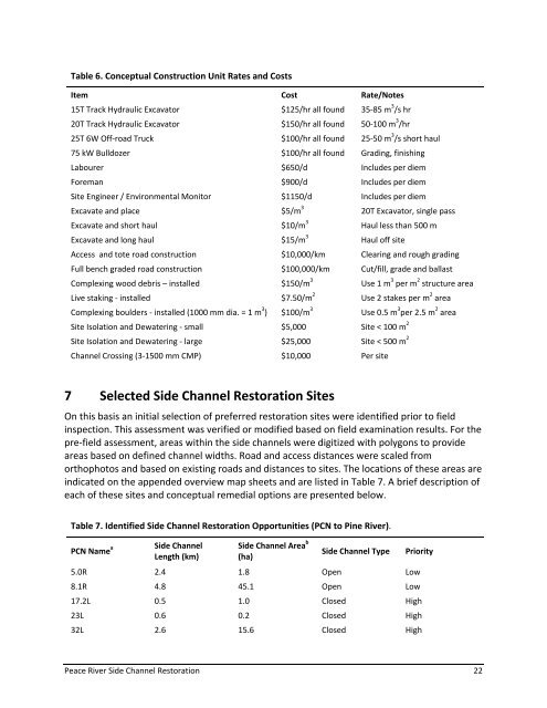
Table 6. Conceptual Construction Unit Rates and Costs<br />
Item Cost Rate/Notes<br />
15T Track Hydraulic Excavator $125/hr all found 35‐85 m 3 /s hr<br />
20T Track Hydraulic Excavator $150/hr all found 50‐100 m 3 /hr<br />
25T 6W Off‐road Truck $100/hr all found 25‐50 m 3 /s short haul<br />
75 kW Bulldozer $100/hr all found Grading, finishing<br />
Labourer $650/d Includes per diem<br />
Foreman $900/d Includes per diem<br />
Site Engineer / Environmental Monitor $1150/d Includes per diem<br />
Excavate and place $5/m 3 20T Excavator, single pass<br />
Excavate and short haul $10/m 3 Haul less than 500 m<br />
Excavate and long haul $15/m 3 Haul off site<br />
Access and tote road construction $10,000/km Clearing and rough grading<br />
Full bench graded road construction $100,000/km Cut/fill, grade and ballast<br />
Complexing wood debris – installed $150/m 3 Use 1 m 3 per m 2 structure area<br />
Live staking ‐ installed $7.50/m 2 Use 2 stakes per m 2 area<br />
Complexing boulders ‐ installed (1000 mm dia. = 1 m 3 ) $100/m 3 Use 0.5 m 3 per 2.5 m 2 area<br />
Site Isolation and Dewatering ‐ small $5,000 Site < 100 m 2<br />
Site Isolation and Dewatering ‐ large $25,000 Site < 500 m 2<br />
<strong>Channel</strong> Crossing (3‐1500 mm CMP) $10,000 Per site<br />
7 Selected <strong>Side</strong> <strong>Channel</strong> <strong>Restoration</strong> Sites<br />
On this basis an initial selection of preferred restoration sites were identified prior to field<br />
inspection. This assessment was verified or modified based on field examination results. For the<br />
pre‐field assessment, areas within the side channels were digitized with polygons to provide<br />
areas based on defined channel widths. Road and access distances were scaled from<br />
orthophotos and based on existing roads and distances to sites. The locations of these areas are<br />
indicated on the appended overview map sheets and are listed in Table 7. A brief description of<br />
each of these sites and conceptual remedial options are presented below.<br />
Table 7. Identified <strong>Side</strong> <strong>Channel</strong> <strong>Restoration</strong> Opportunities (PCN to Pine <strong>River</strong>).<br />
PCN Name a<br />
<strong>Side</strong> <strong>Channel</strong><br />
Length (km)<br />
<strong>Side</strong> <strong>Channel</strong> Area b<br />
(ha)<br />
<strong>Side</strong> <strong>Channel</strong> Type Priority<br />
5.0R 2.4 1.8 Open Low<br />
8.1R 4.8 45.1 Open Low<br />
17.2L 0.5 1.0 Closed High<br />
23L 0.6 0.2 Closed High<br />
32L 2.6 15.6 Closed High<br />
<strong>Peace</strong> <strong>River</strong> <strong>Side</strong> <strong>Channel</strong> <strong>Restoration</strong> 22


