

Wahleach Project Water Use Plan Wahleach Reservoir ... - BC Hydro
Wahleach Project Water Use Plan Wahleach Reservoir ... - BC Hydro
Wahleach Project Water Use Plan Wahleach Reservoir ... - BC Hydro

You also want an ePaper? Increase the reach of your titles
YUMPU automatically turns print PDFs into web optimized ePapers that Google loves.
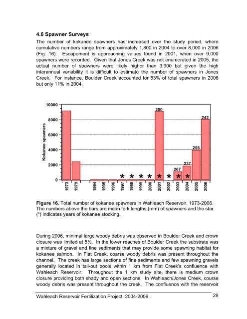
4.6 Spawner Surveys<br />
The number of kokanee spawners has increased over the study period, where<br />
cumulative numbers range from approximately 1,800 in 2004 to over 8,000 in 2006<br />
(Fig. 16). Escapement is approaching values found in 2001, when over 9,000<br />
spawners were recorded. Given that Jones Creek was not enumerated in 2005, the<br />
actual number of spawners were likely higher than 3,900 but given the high<br />
interannual variability it is difficult to estimate the number of spawners in Jones<br />
Creek. For instance, Boulder Creek accounted for 53% of total spawners in 2006<br />
but only 11% in 2004.<br />
Kokanee spawners<br />
10000<br />
8000<br />
6000<br />
4000<br />
2000<br />
0<br />
1973<br />
1979<br />
1994<br />
1995<br />
1996<br />
1997<br />
1998<br />
1999<br />
2000<br />
250<br />
* * * * *<br />
2001<br />
2002<br />
267<br />
2003<br />
237<br />
* * *<br />
Figure 16. Total number of kokanee spawners in <strong>Wahleach</strong> <strong>Reservoir</strong>, 1973-2006.<br />
The numbers above the bars are mean fork lengths (mm) of spawners and the star<br />
(*) indicates years of kokanee stocking.<br />
During 2006, minimal large woody debris was observed in Boulder Creek and crown<br />
closure was limited at 5%. In the lower reaches of Boulder Creek the substrate was<br />
a mixture of gravel and fine sediments that may provide some spawning habitat for<br />
kokanee salmon. In Flat Creek, coarse woody debris was present throughout the<br />
channel. The creek has large sections of fine sediments and few spawning gravels<br />
generally located in tail-out pools within 1 km from Flat Creek’s confluence with<br />
<strong>Wahleach</strong> <strong>Reservoir</strong>. Throughout the 1 km study site, there is medium crown<br />
closure providing both shady and open sections. In <strong>Wahleach</strong>/Jones Creek, course<br />
woody debris was present throughout the creek. The confluence with the reservoir<br />
<strong>Wahleach</strong> <strong>Reservoir</strong> Fertilization <strong>Project</strong>, 2004-2006.<br />
2004<br />
255<br />
2005<br />
242<br />
2006<br />
29


