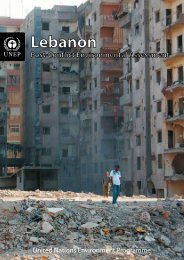
state of the environment in Somalia - Disasters and Conflicts - UNEP
state of the environment in Somalia - Disasters and Conflicts - UNEP
state of the environment in Somalia - Disasters and Conflicts - UNEP

You also want an ePaper? Increase the reach of your titles
YUMPU automatically turns print PDFs into web optimized ePapers that Google loves.
<strong>Somalia</strong> is for <strong>the</strong> most part a flat country, but <strong>the</strong>re is rugged country <strong>in</strong> <strong>the</strong> sou<strong>the</strong>rn <strong>and</strong> central regions <strong>and</strong><br />
<strong>in</strong>l<strong>and</strong> from <strong>the</strong> guban are <strong>the</strong> precipitous north-fac<strong>in</strong>g cliffs <strong>of</strong> <strong>the</strong> Karkaar range, which extends from <strong>the</strong><br />
north-western border with Ethiopia to <strong>the</strong> tip <strong>of</strong> <strong>the</strong> Horn. These are <strong>the</strong> highest mounta<strong>in</strong>s <strong>in</strong> <strong>Somalia</strong>, up to<br />
2,000 m high <strong>and</strong> peak<strong>in</strong>g at 2,407 m with Shimer Berris <strong>in</strong> Sanaag region (EC/IUCN, 1993). To <strong>the</strong> south, <strong>the</strong>y<br />
descend to an elevated plateau devoid <strong>of</strong> perennial rivers. This region <strong>of</strong> broken terra<strong>in</strong>, shallow valleys <strong>and</strong><br />
usually dry watercourses is known as <strong>the</strong> Ogo. The eastern part <strong>of</strong> <strong>the</strong> Ogo gently slopes towards <strong>the</strong> Indian<br />
Ocean <strong>and</strong>, <strong>in</strong> Central <strong>Somalia</strong>, constitutes <strong>the</strong> Mudug pla<strong>in</strong>. An important feature <strong>of</strong> this region is <strong>the</strong> Nugaal<br />
valley which has an extensive network <strong>of</strong> seasonal watercourses. The western part <strong>of</strong> <strong>the</strong> same plateau is<br />
crossed by numerous valleys <strong>and</strong> dry watercourses. This plateau aga<strong>in</strong> slopes gently southwards <strong>and</strong> merges<br />
with <strong>the</strong> Haud, a broad undulat<strong>in</strong>g area that is some <strong>of</strong> <strong>the</strong> best graz<strong>in</strong>g l<strong>and</strong> for nomads, despite a lack <strong>of</strong><br />
ra<strong>in</strong>fall for more than half <strong>the</strong> year. Enhanc<strong>in</strong>g <strong>the</strong> value <strong>of</strong> <strong>the</strong> Haud are natural depressions which become<br />
temporary lakes <strong>and</strong> ponds dur<strong>in</strong>g <strong>the</strong> ra<strong>in</strong>s. South-western <strong>Somalia</strong> is dom<strong>in</strong>ated by <strong>the</strong> country’s two permanent<br />
rivers, <strong>the</strong> Shabeelle <strong>and</strong> <strong>the</strong> Jubba, <strong>and</strong> favourable ra<strong>in</strong>fall <strong>and</strong> soil conditions make this river<strong>in</strong>e area a<br />
fertile agricultural zone <strong>and</strong> <strong>the</strong> centre <strong>of</strong> <strong>the</strong> country’s largest sedentary population.<br />
The coastl<strong>in</strong>e consists <strong>of</strong> a series <strong>of</strong> s<strong>and</strong>y beaches <strong>in</strong>terrupted at <strong>in</strong>tervals by rocky cliffs, some <strong>of</strong> which<br />
protrude <strong>in</strong>to <strong>the</strong> ocean. With a total area <strong>of</strong> 35,000-40,000 km 2 (<strong>UNEP</strong>, 1984), <strong>the</strong> cont<strong>in</strong>ental shelf is generally<br />
narrow, rarely exceed<strong>in</strong>g 15 km <strong>in</strong> breadth, but drops <strong>of</strong>f sharply <strong>in</strong>to deep water. Only between Ras Asir <strong>and</strong><br />
Ras Hafun on <strong>the</strong> north-east coast does <strong>the</strong> shelf extend to almost 80 km <strong>in</strong> some places.<br />
Climate<br />
The climate varies among locations between tropical <strong>and</strong> sub-tropical, <strong>and</strong> between arid <strong>and</strong> semi-arid.<br />
Temperatures <strong>in</strong>l<strong>and</strong> average 28°C, but may be as low as 0°C <strong>in</strong> <strong>the</strong> mounta<strong>in</strong> areas <strong>and</strong> as high as 47°C along<br />
<strong>the</strong> coast. The average annual ra<strong>in</strong>fall is about 280 mm, although this can reach 500 mm <strong>in</strong> some areas, such<br />
as <strong>the</strong> western Ogo highl<strong>and</strong>s (Hughes <strong>and</strong> Hughes, 1992), <strong>and</strong> precipitation <strong>in</strong> generally both negligible <strong>and</strong><br />
erratic, with seasonal totals be<strong>in</strong>g highly variable. Droughts occur every 2-3 years <strong>and</strong> are <strong>of</strong>ten followed by<br />
devastat<strong>in</strong>g floods, particularly <strong>in</strong> <strong>the</strong> south where <strong>the</strong> Shabeelle <strong>and</strong> Jubba are vulnerable to heavy ra<strong>in</strong>s <strong>in</strong><br />
<strong>the</strong> Ethiopian highl<strong>and</strong>s. Between 1961 <strong>and</strong> 2004, 18 floods were recorded <strong>in</strong> <strong>Somalia</strong>, kill<strong>in</strong>g 2,671 people <strong>and</strong><br />
directly affect<strong>in</strong>g <strong>the</strong> lives <strong>of</strong> almost 1.8 million. In <strong>the</strong> same period, <strong>the</strong>re were 12 droughts that killed 19,671<br />
people <strong>and</strong> affected almost four million (Columbia University, 2005).<br />
Erratic <strong>and</strong> unreliable as <strong>the</strong>y are, <strong>the</strong>re are seasonal patterns <strong>of</strong> ra<strong>in</strong>fall that are strongly <strong>in</strong>fluenced by <strong>the</strong><br />
Inter-Tropical Convergence Zone (ITCZ), <strong>the</strong> north-south movement <strong>of</strong> which results <strong>in</strong> two dry seasons <strong>and</strong> two<br />
wet seasons each year. The Jilaal, from January to March, is <strong>the</strong> harshest dry season <strong>and</strong> results from dry<br />
north-easterly w<strong>in</strong>ds sweep<strong>in</strong>g down from <strong>the</strong> Arabian Pen<strong>in</strong>sula. This is followed by <strong>the</strong> Gu ra<strong>in</strong>y season from<br />
April to June, <strong>the</strong>n <strong>the</strong> Hagaa dry season from July to September, dur<strong>in</strong>g which sea breezes from <strong>the</strong> Indian<br />
Ocean help cool at least <strong>the</strong> sou<strong>the</strong>rn parts <strong>of</strong> <strong>the</strong> country. The cycle is completed by <strong>the</strong> Deyr, a short <strong>and</strong><br />
unreliable wet season <strong>in</strong> October <strong>and</strong> November. The coastal region <strong>in</strong> <strong>the</strong> south around Mogadishu <strong>and</strong><br />
Kismayo has an additional ra<strong>in</strong>y season, <strong>the</strong> Xagaaye, <strong>in</strong> July <strong>and</strong> August, dur<strong>in</strong>g which <strong>the</strong>re may be isolated<br />
showers. Livestock husb<strong>and</strong>ry <strong>and</strong> farm<strong>in</strong>g are adapted to this climatic regime, with herds be<strong>in</strong>g concentrated<br />
around water sources <strong>in</strong> <strong>the</strong> Jilaal, but driven to pastures deep <strong>in</strong> <strong>the</strong> <strong>in</strong>terior dur<strong>in</strong>g <strong>the</strong> Gu, when ra<strong>in</strong>fed<br />
agriculture also becomes briefly possible (see map <strong>Somalia</strong>: Topography <strong>and</strong> dra<strong>in</strong>age).<br />
Cultural features<br />
The Cushitic peoples <strong>of</strong> <strong>the</strong> Somali coast <strong>in</strong> <strong>the</strong> Horn <strong>of</strong> Africa have an ancient history. Archaeological<br />
evidence <strong>in</strong>dicates <strong>the</strong>ir presence <strong>in</strong> this region by 100 A.D, <strong>and</strong> possibly earlier. By <strong>the</strong> 7 th century A.D., <strong>the</strong>y<br />
began to m<strong>in</strong>gle with Arab <strong>and</strong> Persian traders who had settled along <strong>the</strong> coast. Interactions <strong>of</strong> this nature<br />
over <strong>the</strong> follow<strong>in</strong>g centuries led to <strong>the</strong> emergence <strong>of</strong> a Somali people bound by common traditions, a s<strong>in</strong>gle<br />
language, <strong>the</strong> Islamic faith, <strong>and</strong> a clan-based social <strong>and</strong> political system.<br />
Environment <strong>in</strong> <strong>Somalia</strong> 10 <strong>UNEP</strong> Desk Study