Tripa IGRSS 2007.indd - congress.cimne.com - UPC
Tripa IGRSS 2007.indd - congress.cimne.com - UPC
Tripa IGRSS 2007.indd - congress.cimne.com - UPC

Create successful ePaper yourself
Turn your PDF publications into a flip-book with our unique Google optimized e-Paper software.
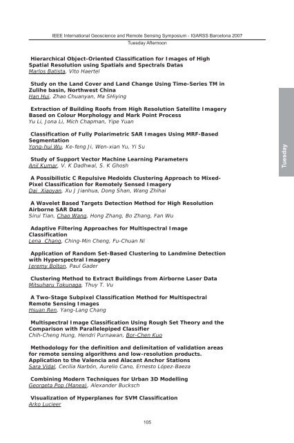
IEEE International Geoscience and Remote Sensing Symposium - IGARSS Barcelona 2007<br />
Tuesday Afternoon<br />
Hierarchical Object-Oriented Classification for Images of High<br />
Spatial Resolution using Spatials and Spectrals Datas<br />
Marlos Batista, Vito Haertel<br />
Study on the Land Cover and Land Change Using Time-Series TM in<br />
Zulihe basin, Northwest China<br />
Han Hui, Zhao Chuanyan, Ma SHiying<br />
Extraction of Building Roofs from High Resolution Satellite Imagery<br />
Based on Colour Morphology and Mark Point Process<br />
Yu Li, Jona Li, Mich Chapman, Yipe Yuan<br />
Classification of Fully Polarimetric SAR Images Using MRF-Based<br />
Segmentation<br />
Yong-hui Wu, Ke-feng Ji, Wen-xian Yu, Yi Su<br />
Study of Support Vector Machine Learning Parameters<br />
Anil Kumar, V. K Dadhwal, S. K Ghosh<br />
A Possibilistic C Repulsive Medoids Clustering Approach to Mixed-<br />
Pixel Classification for Remotely Sensed Imagery<br />
Dai Xiaoyan, Xu J Jianhua, Dong Shan, Wang Zhihai<br />
A Wavelet Based Targets Detection Method for High Resolution<br />
Airborne SAR Data<br />
Sirui Tian, Chao Wang, Hong Zhang, Bo Zhang, Fan Wu<br />
Adaptive Filtering Approaches for Multispectral Image<br />
Classification<br />
Lena Chang, Ching-Min Cheng, Fu-Chuan Ni<br />
Application of Random Set-Based Clustering to Landmine Detection<br />
with Hyperspectral Imagery<br />
Jeremy Bolton, Paul Gader<br />
Clustering Method to Extract Buildings from Airborne Laser Data<br />
Mitsuharu Tokunaga, Thuy T. Vu<br />
A Two-Stage Subpixel Classification Method for Multispectral<br />
Remote Sensing Images<br />
Hsuan Ren, Yang-Lang Chang<br />
Multispectral Image Classification Using Rough Set Theory and the<br />
Comparison with Parallelepiped Classifier<br />
Chih-Cheng Hung, Hendri Purnawan, Bor-Chen Kuo<br />
Methodology for the definition and delimitation of validation areas<br />
for remote sensing algorithms and low-resolution products.<br />
Application to the Valencia and Alacant Anchor Stations<br />
Sara Vidal, Cecilia Narbón, Aurelio Cano, Ernesto López-Baeza<br />
Combining Modern Techniques for Urban 3D Modelling<br />
Georgeta Pop (Manea), Alexander Bucksch<br />
Visualization of Hyperplanes for SVM Classification<br />
Arko Lucieer<br />
105<br />
Tuesday