Tripa IGRSS 2007.indd - congress.cimne.com - UPC
Tripa IGRSS 2007.indd - congress.cimne.com - UPC
Tripa IGRSS 2007.indd - congress.cimne.com - UPC

Create successful ePaper yourself
Turn your PDF publications into a flip-book with our unique Google optimized e-Paper software.
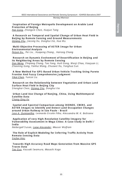
IEEE International Geoscience and Remote Sensing Symposium - IGARSS Barcelona 2007<br />
Monday Afternoon<br />
Inspiration of Foreign Metropolis Development on Arable Land<br />
Protection of Beijing<br />
Pan Gong, Zhongxin Chen, Huajun Tang<br />
A Research on Temporal and Spatial Change of Urban Heat Field in<br />
Beijing by Remote Sensing and Ground Measurements<br />
Qijiang Zhu, Jiacong Hu, Donghui Xie, Hua Wu<br />
Multi-Objective Processing of ASTER Image for Urban<br />
Environmental Analysis<br />
Peijun Du , Pei Liu , Huapeng Zhang , Hairong Zhang<br />
Research on Dynamic Evolvement of Desertification in Beijing and<br />
its Neighboring Areas by Remote Sensing<br />
Dan Meng, Zhiqiang Zhang, Tao Yang, Huili Gong, Wenji Zhao, Xiaojuan Li,<br />
Zhaoning Gong, Yanhui Wang, Zhuowei Hu, Yonghua Sun<br />
A New Method For GPS-Based Urban Vehicle Tracking Using Pareto<br />
Frontier And Fuzzy Comprehensive Judgment<br />
Yikai Chen, Yuncai Liu<br />
Research on the Relationship between Vegetation and Urban Land<br />
Surface Heat Field in Beijing City<br />
Shenghai Chen, Qijiang Zhu, Donghui Xie<br />
Urban Land Use Change of Nanjing, China, Using Multitemporal<br />
Satellite Data<br />
Chang-Qing Ke<br />
Spatial and Spectral Comparison among IKONOS, CBERS, and<br />
ASTER Images to Identify and Detect Land Occupation Changes<br />
around Urban Railway in Säo Paulo - Brazil<br />
Jose A. Quintanilha, Leonardo Ercolin Filho, Alessandra M. K. Beltrame<br />
Application of very High-Resolution Satellite Imagery for<br />
Vulnerability Assessment in Mega Cities: A Case Study in Delhi /<br />
India<br />
Niebergall Susan, Loew Alexander, Mauser Wolfram<br />
The Role of Explicit Modeling for Inferring Traffic Activity from<br />
Remote Sensing Data<br />
Stefan Hinz<br />
Towards High Accuracy Road Maps Generation from Massive GPS<br />
Traces Data<br />
Tao Guo, Kazuaki Iwamura, Masashi Koga<br />
55<br />
Monday