

APAALSE - Paper - Caris
APAALSE - Paper - Caris
APAALSE - Paper - Caris
- TAGS
- apaalse
- paper
- caris
- www.caris.com

Create successful ePaper yourself
Turn your PDF publications into a flip-book with our unique Google optimized e-Paper software.
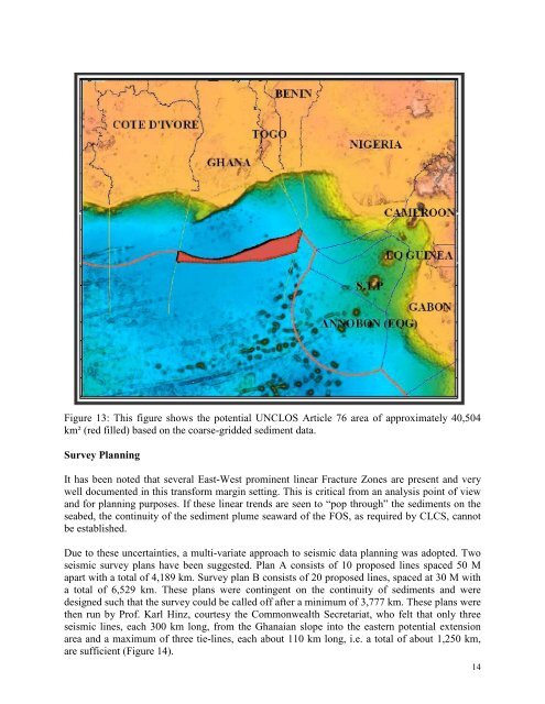
Figure 13: This figure shows the potential UNCLOS Article 76 area of approximately 40,504<br />
km² (red filled) based on the coarse-gridded sediment data.<br />
Survey Planning<br />
It has been noted that several East-West prominent linear Fracture Zones are present and very<br />
well documented in this transform margin setting. This is critical from an analysis point of view<br />
and for planning purposes. If these linear trends are seen to “pop through” the sediments on the<br />
seabed, the continuity of the sediment plume seaward of the FOS, as required by CLCS, cannot<br />
be established.<br />
Due to these uncertainties, a multi-variate approach to seismic data planning was adopted. Two<br />
seismic survey plans have been suggested. Plan A consists of 10 proposed lines spaced 50 M<br />
apart with a total of 4,189 km. Survey plan B consists of 20 proposed lines, spaced at 30 M with<br />
a total of 6,529 km. These plans were contingent on the continuity of sediments and were<br />
designed such that the survey could be called off after a minimum of 3,777 km. These plans were<br />
then run by Prof. Karl Hinz, courtesy the Commonwealth Secretariat, who felt that only three<br />
seismic lines, each 300 km long, from the Ghanaian slope into the eastern potential extension<br />
area and a maximum of three tie-lines, each about 110 km long, i.e. a total of about 1,250 km,<br />
are sufficient (Figure 14).<br />
14


