D28: Internal seiche mixing study - Hydromod
D28: Internal seiche mixing study - Hydromod
D28: Internal seiche mixing study - Hydromod

You also want an ePaper? Increase the reach of your titles
YUMPU automatically turns print PDFs into web optimized ePapers that Google loves.
Integrated Water Resource Management for Important Deep European Lakes and their Catchment Areas<br />
EUROLAKES<br />
<strong>D28</strong>: <strong>Internal</strong> <strong>seiche</strong> <strong>mixing</strong> <strong>study</strong><br />
3 INTERNAL SEICHES AND MIXING IN LAC LÉMAN<br />
3.1 THE LAC LÉMAN ENVIRONMENT<br />
FP5_Contract No.: EVK1-CT1999-00004<br />
Version: 1.2<br />
Date: 24.08.2004<br />
File: <strong>D28</strong>.doc<br />
Page 21 of 92<br />
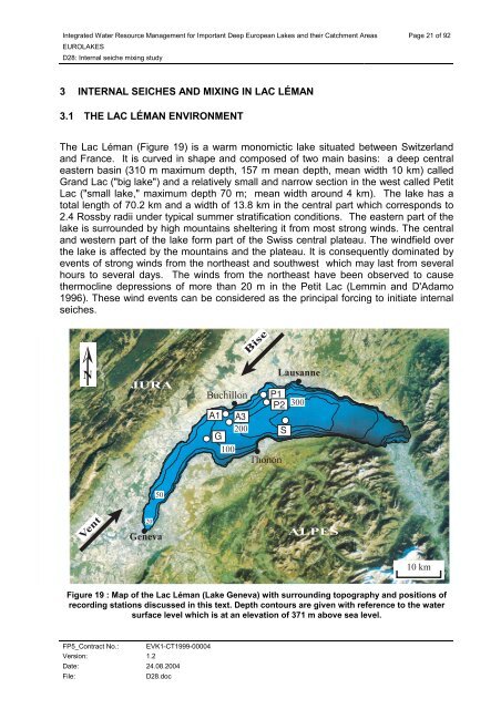
The Lac Léman (Figure 19) is a warm monomictic lake situated between Switzerland<br />
and France. It is curved in shape and composed of two main basins: a deep central<br />
eastern basin (310 m maximum depth, 157 m mean depth, mean width 10 km) called<br />
Grand Lac ("big lake") and a relatively small and narrow section in the west called Petit<br />
Lac ("small lake," maximum depth 70 m; mean width around 4 km). The lake has a<br />
total length of 70.2 km and a width of 13.8 km in the central part which corresponds to<br />
2.4 Rossby radii under typical summer stratification conditions. The eastern part of the<br />
lake is surrounded by high mountains sheltering it from most strong winds. The central<br />
and western part of the lake form part of the Swiss central plateau. The windfield over<br />
the lake is affected by the mountains and the plateau. It is consequently dominated by<br />
events of strong winds from the northeast and southwest which may last from several<br />
hours to several days. The winds from the northeast have been observed to cause<br />
thermocline depressions of more than 20 m in the Petit Lac (Lemmin and D'Adamo<br />
1996). These wind events can be considered as the principal forcing to initiate internal<br />
<strong>seiche</strong>s.<br />
�<br />
����<br />
����<br />
��<br />
��<br />
������<br />
���������<br />
��<br />
�<br />
���<br />
��<br />
���<br />
����<br />
������<br />
��������<br />
Figure 19 : Map of the Lac Léman (Lake Geneva) with surrounding topography and positions of<br />
recording stations discussed in this text. Depth contours are given with reference to the water<br />
surface level which is at an elevation of 371 m above sea level.<br />
��<br />
��<br />
�<br />
���<br />
�����<br />
�� ��