

La relazione del Piano delle Regole - Comune di Galbiate
La relazione del Piano delle Regole - Comune di Galbiate
La relazione del Piano delle Regole - Comune di Galbiate

You also want an ePaper? Increase the reach of your titles
YUMPU automatically turns print PDFs into web optimized ePapers that Google loves.
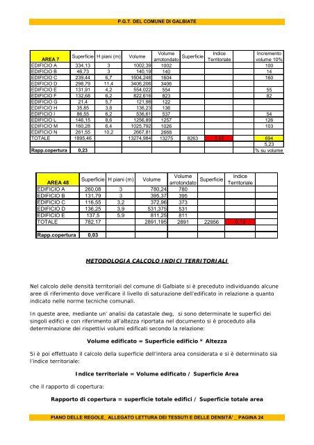
P.G.T. DEL COMUNE DI GALBIATE<br />
AREA 7<br />
Superficie H piani (m) Volume<br />
Volume<br />
arrotondato Superficie<br />
In<strong>di</strong>ce<br />
Territoriale<br />
Incremento<br />
volume 10%<br />
EDIFICIO A 334,13 3 1002,39 1002 100<br />
EDIFICIO B 46,73 3 140,19 140 14<br />
EDIFICIO C 239,44 6,7 1604,248 1604 160<br />
EDIFICIO D 298,79 11,4 3406,206 3406<br />
EDIFICIO E 131,91 4,2 554,022 554 55<br />
EDIFICIO F 132,68 6,2 822,616 823 82<br />
EDIFICIO G 21,4 5,7 121,98 122<br />
EDIFICIO H 35,85 3,8 136,23 136<br />
EDIFICIO I 86,55 6,2 536,61 537 54<br />
EDIFICIO L 146,15 8,6 1256,89 1257 126<br />
EDIFICIO M 160,28 6,4 1025,792 1026 103<br />
EDIFICIO N 261,55 10,2 2667,81 2668<br />
TOTALE 1895,46 13274,984 13275 8263 1,61 694<br />
5,23<br />
Rapp.copertura 0,23 % su volume<br />
AREA 48<br />
Superficie H piani (m) Volume<br />
Volume<br />
arrotondato Superficie<br />
In<strong>di</strong>ce<br />
Territoriale<br />
EDIFICIO A 260,08 3 780,24 780<br />
EDIFICIO B 131,79 3 395,37 395<br />
EDIFICIO C 116,55 3,2 372,96 373<br />
EDIFICIO D 136,25 3,9 531,375 531<br />
EDIFICIO E 137,5 5,9 811,25 811<br />
TOTALE 782,17 2891,195 2891 22956 0,13<br />
Rapp.copertura 0,03<br />
METODOLOGIA CALCOLO INDICI TERRITORIALI<br />
Nel calcolo <strong>del</strong>le densità territoriali <strong>del</strong> comune <strong>di</strong> <strong>Galbiate</strong> si è preceduto in<strong>di</strong>viduando alcune<br />
aree <strong>di</strong> riferimento dove verificare il livello <strong>di</strong> saturazione <strong>del</strong>l’e<strong>di</strong>ficato in <strong>relazione</strong> a quanto<br />
in<strong>di</strong>cato nelle norme tecniche comunali.<br />
In queste aree, me<strong>di</strong>ante un’ analisi da catastale dwg, si sono determinate le superfici dei<br />
singoli e<strong>di</strong>fici e con riferimento all’altezza riportata nel documento si è proceduto alla<br />
determinazione dei rispettivi volumi e<strong>di</strong>ficati secondo la <strong>relazione</strong>:<br />
Volume e<strong>di</strong>ficato = Superficie e<strong>di</strong>ficio * Altezza<br />
Si è poi effettuato il calcolo <strong>del</strong>la superficie <strong>del</strong>l’intera area considerata e si è determinato sia<br />
l’in<strong>di</strong>ce territoriale:<br />
che il rapporto <strong>di</strong> copertura:<br />
In<strong>di</strong>ce territoriale = Volume e<strong>di</strong>ficato / Superficie Area<br />
Rapporto <strong>di</strong> copertura = superficie totale e<strong>di</strong>fici / Superficie totale area<br />
PIANO DELLE REGOLE_ ALLEGATO LETTURA DEI TESSUTI E DELLE DENSITÀ’ _ PAGINA 24