spezial 2013 - August Laube
spezial 2013 - August Laube
spezial 2013 - August Laube

Sie wollen auch ein ePaper? Erhöhen Sie die Reichweite Ihrer Titel.
YUMPU macht aus Druck-PDFs automatisch weboptimierte ePaper, die Google liebt.
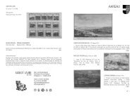
35 Nova Helvetia Tabula geographica Illustrissimis et<br />
Potentissimis Cantonibus et Rebuspublicis Reformatae.<br />
Religionis… dicata A Joh. Jacobo Scheuchzero Tigurino,<br />
Med. D. Math. Prof. Amsterdam, Peter Schenk (1715)<br />
Karte der Schweiz in 4 kol. Kupfertafeln. Gesamtgrösse:<br />
87:111 cm.<br />
Blumer 166. Johann Jakob Scheuchzer, Stadtarzt von<br />
Zürich und bedeutender Naturforscher, Mathematiker,<br />
Physiker und Geograph, reiste in der Schweiz herum und<br />
sammelte, ähnlich wie Tschudi und Stumpf für ihre Geschichtswerke,<br />
Material für eine «Naturgeschichte des<br />
Schweizerlandes». Er zeichnete verschiedene kleine Regionalkarten<br />
für eine grössere Schweizer Karte, die er nach<br />
achtzehnjähriger Arbeit 1712 veröffentlichte. Diese grosse<br />
Schweizer Karte beruht auf der Gygerschen von 1657<br />
und auf der grossen vierblätterigen von Jaillot. Sie stellt<br />
das kartographische Hauptwerk des 18. Jahrhunderts dar<br />
und diente vielfach als Grundlage für weitere Karten. Die<br />
Scheuchzer-Karte ist die letzte kartographische Schöpfung<br />
grossen Massstabes, die letzte grosse Übersichtskarte der<br />
Schweiz der alten Kartenperiode, das heisst vor den geometrischen<br />
Vermessungen wie sie im Laufe des 18. Jahrhunderts<br />
auch immer mehr in der Schweiz zur Ausführung<br />
gelangten.<br />
Genauer und sorgfältiger Nachstich der Zürcher Ausgabe<br />
der Scheuchzer-Karte in etwas kleinerem Massstab und<br />
mit ähnlichen Bildern ausserhalb der Landesgrenze. Im<br />
oberen Rand Aufzählung der 13 alten Orte, der Zugewandten<br />
und der Landvogteien. Mit holländischem und lateinischem<br />
Text.<br />
HELVETICA<br />
40<br />
35 Nova Helvetia Tabula geographica Illustrissimis et Potentissimis<br />
Cantonibus et Rebuspublicis Reformatae. Religionis…<br />
dicata A Joh. Jacobo Scheuchzero Tigurino, Med.<br />
D. Math. Prof. Amsterdam, Peter Schenk (1715) Map of<br />
Switzerland in 4 joint colored copper engravings. Total<br />
size: 87:111 cm.<br />
Blumer 166. Johan Jakob Scheuchzer, the municipal doctor<br />
of Zurich and distinguished natural scientist, mathematician,<br />
physicist, and geographer, travelled throughout<br />
Switzerland and collected materials for his natural history<br />
of Switzerland, as did Tschudi and Stumpf for their works.<br />
He drew several small regional maps in order to produce<br />
a large map of Switzerland, which, after 18 years of work,<br />
was finally published in 1712. This large-scale Swiss map<br />
was based on the Gyger map of 1657 and the larger fourpage<br />
map by Jaillot. It is the principle Swiss cartographical<br />
work of the 18th century and served as a basis for most<br />
other maps. The Scheuchzer map is the last significant cartographical<br />
piece on such a large scale, and the final large<br />
overview map of Switzerland belonging to the old map era<br />
before using the metric system for measurements, which<br />
went into use in Switzerland in the 18th century.<br />
Exact and careful rendering of the Zurich edition of<br />
Scheuchzer’s map on a slightly smaller scale, with similar<br />
pictures outside the map borders. In the top margin there<br />
is a list of the 13 old cantons, the newer cantons, and the<br />
royal provinces. With Dutch and Latin text.