28.9.00 Aufbau GeoWorld 5 - Mettenmeier GmbH
28.9.00 Aufbau GeoWorld 5 - Mettenmeier GmbH
28.9.00 Aufbau GeoWorld 5 - Mettenmeier GmbH

Sie wollen auch ein ePaper? Erhöhen Sie die Reichweite Ihrer Titel.
YUMPU macht aus Druck-PDFs automatisch weboptimierte ePaper, die Google liebt.
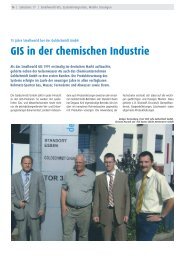
18 <strong>GeoWorld</strong> <strong>Mettenmeier</strong> Aus den Projekten<br />
GIS Service Prague Gathers<br />
Experience on Mainz Project<br />
The SW Mainz Project became<br />
the first completely independently<br />
led project of GIS Service<br />
Prague spol. s r.o.<br />
During the third quarter of 1999, work<br />
on the SW Mainz project started at GIS<br />
Service Prague spol. s r .o. company. The<br />
goal of this project was to transform the<br />
existing analogue and digital documentation<br />
of the distribution system of gas<br />
and water for the Stadtwerke Mainz into<br />
a homogenous form enabling problemfree<br />
conversion to the GIS system.<br />
Project Parameters<br />
Gas distribution network<br />
length of main pipes<br />
network (GHL) 680 km<br />
number of service<br />
connections (GHA) 34,000<br />
Water distribution network<br />
length of main pipes<br />
network (GHL) 820 km<br />
number of service<br />
connections (GHA) 34,000<br />
Project duration 3 years<br />
Source documentation<br />
analogue plans 1:500 (0.5m x 0.5m)<br />
– database of field outlines in Microsoft<br />
ACCESS system (total of 44,000)<br />
– digital land register in the Micro-<br />
Station format (*.dgn)<br />
– existing digital documentation of distribution<br />
networks in the Micro-<br />
Station format (*.dgn)<br />
System Selection and Data Structure<br />
The system for conversion of documentation<br />
and its maintenance is Micro-<br />
Station (MS 95). In this stage of the project,<br />
no external database information<br />
are attached to the graphical elements<br />
and all descriptive attributes are recor-<br />
ded in the graphical file in the MS TAG<br />
form. With respect to specific requirements<br />
of the client it was necessary to<br />
create a special application upgrade enabling<br />
easier and error-free data conversion.<br />
The processing unit (conversion, data<br />
transfer, archiving) shall be square kilometer<br />
(1 KiQu). In the framework of<br />
this unit all digital documentation is<br />
processed with the following data structure<br />
in the MicroStation format (*.dgn):<br />
– file of distribution networks Gas,<br />
Wasser (g5032.dgn,w5032.dgn)<br />
– file of digital land register (k5032.<br />
dgn)<br />
– file of thematic information (s5032.<br />
dgn)<br />
– file of the existing digital documentation<br />
of distribution networks (gnd<br />
5032.dgn)<br />
Some data are processed by map sheets:<br />
– file of discrepancies and errors upon<br />
data conversion (5032410g.uns)<br />
– file of map sheet frames in the scale<br />
1:500 (g5032410.dgn)<br />
Data Conversion<br />
Digitalization<br />
The digitalization itself is carried out<br />
according to the valid rules delivered by<br />
the customer. In the first stage, the network<br />
main pipes network and subsequently<br />
service connections are converted.<br />
To assure location accuracy given by<br />
the digitalization regulation a pre-construction<br />
of the distribution network is<br />
carried out. Maximum permitted error<br />
in pipe location is 1m. A further step is<br />
drawing-in the networks with subsequent<br />
creation of objects and attachment<br />
of descriptive attributes (pipe diameter,<br />
year of built, pipe material, specific<br />
information on pipe, etc.). After<br />
complete creation of objects, the pipes<br />
are dimensioned. For unclear places,<br />
details are digitized, and for illustration<br />
of height conditions section details are<br />
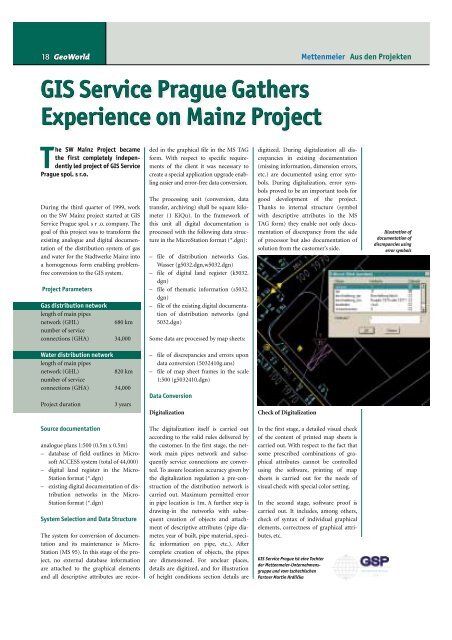
digitized. During digitalization all discrepancies<br />
in existing documentation<br />
(missing information, dimension errors,<br />
etc.) are documented using error symbols.<br />
During digitalization, error symbols<br />
proved to be an important tools for<br />
good development of the project.<br />
Thanks to internal structure (symbol<br />
with descriptive attributes in the MS<br />
TAG form) they enable not only documentation<br />
of discrepancy from the side<br />
of processor but also documentation of<br />
solution from the customer’s side.<br />
Check of Digitalization<br />
In the first stage, a detailed visual check<br />
of the content of printed map sheets is<br />
carried out. With respect to the fact that<br />
some prescribed combinations of graphical<br />
attributes cannot be controlled<br />
using the software, printing of map<br />
sheets is carried out for the needs of<br />
visual check with special color setting.<br />
In the second stage, software proof is<br />
carried out. It includes, among others,<br />
check of syntax of individual graphical<br />
elements, correctness of graphical attributes,<br />
etc.<br />
GIS Service Prague ist eine Tochter<br />
der <strong>Mettenmeier</strong>-Unternehmensgruppe<br />
und vom tschechischen<br />
Partner Martin Hrdlička<br />
Illustration of<br />
documentation of<br />
discrepancies using<br />
error symbols