crpf samachar may_ june-2012 - Central Reserve Police Force
crpf samachar may_ june-2012 - Central Reserve Police Force
crpf samachar may_ june-2012 - Central Reserve Police Force

Create successful ePaper yourself
Turn your PDF publications into a flip-book with our unique Google optimized e-Paper software.
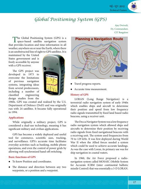
Global Positioning System (GPS)<br />
The Global Positioning System (GPS) is a<br />
space-based satellite navigation system<br />
that provides location and time information in all<br />
weather, anywhere on or near the Earth, where there<br />
is an unobstructed line of sight to GPS satellites. It is<br />
maintained by the United<br />
States government and is<br />
freely accessible by anyone<br />
with a GPS receiver.<br />
The GPS project was<br />
developed in 1973 to<br />
overcome the limitations<br />
of previous navigation<br />
systems, integrating ideas<br />
from several predecessors,<br />
including a number of<br />
classified engineering<br />
design studies from the<br />
1960s. GPS was created and realized by the U.S.<br />
Department of Defence (DoD) and was originally<br />
run with 24 satellites. It became fully operational<br />
in 1994.<br />
Applications<br />
While originally a military project, GPS is<br />
considered a dual-use technology, meaning it has<br />
significant military and civilian applications.<br />
GPS has become a widely deployed and useful<br />
tool for commerce, scientific uses, tracking,<br />
and surveillance. GPS's accurate time facilitates<br />
everyday activities such as banking, mobile phone<br />
operations, and even the control of power grids by<br />
allowing well synchronized hand-off switching.<br />
Basic functions of GPS<br />
� To know Position and coordinates.<br />
� The distance and direction between any two<br />
waypoints, or a position and a waypoint.<br />
� Travel progress reports.<br />
� Accurate time measurement.<br />
ebZ&twu <strong>2012</strong><br />
Technical Feature<br />
Ajay Dwivedi,<br />
Dy. Commandant,<br />
CIT Bangalore<br />
History of GPS<br />
LORAN (Long Range Navigation) is a<br />
terrestrial radio navigation system of early 1940s<br />
which enables ships and aircraft to determine<br />
their position and speed from low frequency<br />
radio signals transmitted by fixed land based radio<br />
beacons, using a receiver unit.<br />
The Decca Navigator System was a low frequency<br />
radio navigation system which allowed ships and<br />
aircrafts to determine their position by receiving<br />
radio signals from fixed navigational beacons with<br />
a receiving unit. The system used frequencies from<br />
70 to 129 kHz. It was first deployed during World<br />
War II when the Allied forces needed a system<br />
which could be used to achieve accurate landings.<br />
As was the case with Loran, its primary use was for<br />
ship navigation in coastal waters.<br />
In 1960, the Air <strong>Force</strong> proposed a radionavigation<br />
system called MOSAIC (Mobile System<br />
for Accurate ICBM (inter continental ballistic<br />
missile Control) that was essentially a 3-D LORAN.<br />
17