

MapInfo Spatial Server Web Map Service - Product Documentation ...
MapInfo Spatial Server Web Map Service - Product Documentation ...
MapInfo Spatial Server Web Map Service - Product Documentation ...

You also want an ePaper? Increase the reach of your titles
YUMPU automatically turns print PDFs into web optimized ePapers that Google loves.
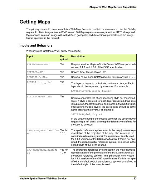
Getting <strong>Map</strong>s<br />
The primary reason to use or establish a <strong>Web</strong> <strong>Map</strong> <strong>Server</strong> is to obtain or serve maps. Use the Get<strong>Map</strong><br />
request to obtain images from a WMS server. Get<strong>Map</strong> requests are always sent as HTTP strings and<br />
the response is a map image with well-defined geospatial and dimensional parameters in the image<br />
format specified in the request.<br />
Inputs and Behaviors<br />
When invoking Get<strong>Map</strong> a WMS query can specify:<br />
Input<br />
VERSION=version<br />
SERVICE=WMS<br />
REQUEST=Get<strong>Map</strong><br />
LAYERS=layer_list<br />
STYLES=style_list<br />
SRS=namespace:identifier<br />
CRS=namespace:identifier<br />
Required<br />
Yes<br />
Yes<br />
Yes<br />
Yes<br />
Yes<br />
Yes for<br />
1.1.1<br />
Yes for<br />
1.3.0<br />
<strong><strong>Map</strong>Info</strong> <strong>Spatial</strong> <strong>Server</strong> <strong>Web</strong> <strong>Map</strong> <strong>Service</strong><br />
Description<br />
Request version. <strong><strong>Map</strong>Info</strong> <strong>Spatial</strong> <strong>Server</strong> WMS supports both<br />
version 1.1.1 and 1.3.0 of the OGC specification.<br />
<strong>Service</strong> type. This is always WMS.<br />
Request name. For a Get<strong>Map</strong> request this is always Get<strong>Map</strong>.<br />
The layer or layers to be included in the map image. Each<br />
layer should be separated by a comma. For example:<br />
LAYERS=Layer1,Layer2,Layer3<br />
Comma-separated list of one rendering style per requested<br />
layer. A style is required for each layer requested. If no style<br />
is requested, the attribute must be present but without a value.<br />
If requesting multiple layers, the styles listed should be in the<br />
same order as the layers. For example:<br />
STYLES=Style1,,Style3<br />
Chapter 3: <strong>Web</strong> <strong>Map</strong> <strong>Service</strong> Capabilities<br />
In the above example the second style (for the second layer<br />
requested) is left blank, allowing the default style defined for<br />
the layer to be used.<br />
The spatial reference system used in the map (numeric representation<br />
of the projection of the map, also known as the<br />
coordinate reference system). This parameter is only used<br />
for 1.1.1 versions of the OGC specification. If this is not specified,<br />
the default spatial reference system, as defined in the<br />
default style of the layer, is used.<br />
The coordinate reference system used in the map (numeric<br />
representation of the projection of the map, also known as<br />
the spatial reference system). This parameter is only used<br />
for 1.1.1 versions of the OGC specification. If this is not specified,<br />
the default coordinate reference system, as defined in<br />
the default style of the layer, is used.<br />
23


