Lake Brownwood Watershed - Texas State Soil and Water ...
Lake Brownwood Watershed - Texas State Soil and Water ...
Lake Brownwood Watershed - Texas State Soil and Water ...

Create successful ePaper yourself
Turn your PDF publications into a flip-book with our unique Google optimized e-Paper software.
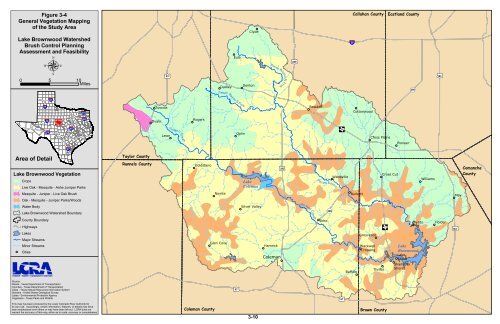
Figure 3-4<br />
General Vegetation Mapping<br />
of the Study Area<br />
<strong>Lake</strong> <strong>Brownwood</strong> <strong><strong>Water</strong>shed</strong><br />
Brush Control Planning<br />
Assessment <strong>and</strong> Feasibility<br />
µ<br />
0 5 10<br />
Miles<br />
§¨¦<br />
27 §¨¦<br />
40<br />
20 §¨¦<br />
10 §¨¦<br />
Area of Detail<br />
37 §¨¦<br />
Source:<br />
Roads - <strong>Texas</strong> Department of Transportation<br />
Counties - <strong>Texas</strong> Department of Transportation<br />
Cities - <strong>Texas</strong> Natural Resources Information System<br />
Streams - United <strong>State</strong>s Geological Survey<br />
<strong>Lake</strong>s - Environmental Protection Agency<br />
Vegetation - <strong>Texas</strong> Parks <strong>and</strong> Wildlife<br />
35 §¨¦<br />
<strong>Lake</strong> <strong>Brownwood</strong> Vegetation<br />
Crops<br />
§¨¦<br />
20 §¨¦<br />
30<br />
Live Oak - Mesquite - Ashe Juniper Parks<br />
Mesquite - Juniper - Live Oak Brush<br />
Oak - Mesquite - Juniper Parks/Woods<br />
<strong>Water</strong> Body<br />
<strong>Lake</strong> <strong>Brownwood</strong> <strong><strong>Water</strong>shed</strong> Boundary<br />
County Boundary<br />
Highways<br />
<strong>Lake</strong>s<br />
Major Streams<br />
Minor Streams<br />
Cities<br />
This map has been produced by the Lower Colorado River Authority for<br />
its own use. Accordingly, certain information, features, or details may have<br />
been emphasized over others or may have been left out. LCRA does not<br />
warrant the accuracy of this map, either as to scale, accuracy or completeness.<br />
Taylor County<br />
Runnels County<br />
Ovalo<br />
tu 83<br />
Tuscola<br />
Lawn<br />
Ji m Ned Cre e k<br />
Rogers<br />
Goldsboro<br />
Eula<br />
Pecan Bayou S For k<br />
Novice<br />
Dudley<br />
Glen Cove<br />
tu 67<br />
Oplin<br />
Clyde<br />
Denton<br />
<strong>Lake</strong><br />
Coleman<br />
Silver Valley<br />
Pecan Bayou N Fork<br />
Hamrick<br />
Coleman<br />
tu 283<br />
tu 283<br />
Jim Ned Cre e k<br />
Rowden<br />
P e can Bayou<br />
Echo<br />
!( 206<br />
?{<br />
Webbville<br />
tu 67<br />
§¨¦ 20<br />
Burkett<br />
Buffalo<br />
Callahan County<br />
Cottonwood<br />
Grosvenor<br />
Blackwell<br />
Crossing<br />
Cross Plains<br />
Thrifty<br />
Coleman County Brown County<br />
3-10<br />
Eastl<strong>and</strong> County<br />
Cross Cut<br />
Pioneer<br />
!( 206<br />
Aç tu 183<br />
Byrds<br />
<strong>Lake</strong><br />
<strong>Brownwood</strong><br />
<strong>Lake</strong><br />
Shore<br />
Shamrock<br />
Shores<br />
Williams<br />
tu 183<br />
Holder<br />
May<br />
Comanche<br />
County