Extended Abstract - AMS supported meetings
Extended Abstract - AMS supported meetings
Extended Abstract - AMS supported meetings

Create successful ePaper yourself
Turn your PDF publications into a flip-book with our unique Google optimized e-Paper software.
P2.17<br />
PERFORMANCE OF THE WRF-ARW IN THE COMPLEX TERRAIN OF SALT LAKE<br />
CITY<br />
1. INTRODUCTION<br />
The Army Research Laboratory has an interest in<br />
high spatial and temporal resolution weather<br />
products with an emphasis on the boundary layer<br />
in complex terrain. In order to study and<br />
investigate small-scale weather processes, the<br />
advanced research Weather Research and<br />
Forecasting model (WRF-ARW) was run over a<br />
variety of locations. One of the more intriguing<br />
model areas of study was over the Salt Lake City<br />
(SLC) area where a nested version of the model<br />
was run for a 24-h period mainly during the cold<br />
season. Approximately 40 model runs were<br />
completed and results of the temperature, dew<br />
point, wind speed, and wind direction were<br />
examined over the forecast period. One of the<br />
main objectives of the 2-km model runs was to<br />
study the interaction of the Lake breeze, valley<br />
breeze, and downslope winds off the local<br />
terrain. Results show that the WRF-ARW had a<br />
bias to overforecast the downslope winds from the<br />
east, underforecast the downslope winds from the<br />
west, and performed well in forecasting the Lake<br />
breeze. The most accurate wind speeds were<br />
noted at 1200 UTC, but the model<br />
underforecasted wind speeds during the afternoon<br />
hours. This paper will investigate some of these<br />
trends and evaluate the performance of the model<br />
in this difficult and complicated forecast region.<br />
_______________________________________<br />
Corresponding author address: Jeffrey.E.<br />
Passner, White sands Missile Range, New Mexico<br />
88002-5501; e-mail: jpassner@arl.army.mil<br />
Jeffrey E. Passner<br />
U.S. Army Research Laboratory<br />
White Sands Missile Range, New Mexico<br />
2. THE WRF MODEL CONFIGURATION<br />
The WRF runs at Salt Lake City were completed<br />
using version 2.1.1; however, the recent WRF<br />
models were run with version 2.1.2 and<br />
demonstrated in section 4 of this paper. All the<br />
models run were utilized with the advanced<br />
research WRF-ARW dynamical core and were<br />
initialized with 0000 universal time coordinate<br />
(UTC) 40-km ETA model data. The models were<br />
run for a period of 24 hours with model output<br />
available every hour. A two-nest configuration was<br />
used, with the outer domain having 8-km grid<br />
resolution and the inner domain having a 2-km<br />
grid resolution, although the model output shown<br />
in section 4 used a three nest configuration of 18km,<br />
6-km, and 2-km grid resolutions.<br />
The physics packages used for all model runs<br />
were:<br />
• Lin microphysics<br />
• RRTM long-wave radiation<br />
• Dudhia short-wave radiation<br />
• MM5 similarity for surface-layer<br />
physics<br />
• Noah land surface model<br />
• Yonsei University scheme for<br />
planetary boundary layer<br />
• Kain-Fritsch cumulus<br />
parameterization for 8-km grids<br />
only<br />
• Four soil layers<br />
3. CHARCTERISTICS OF SALT LAKE CITY<br />
WINDS<br />
The SLC area is one of the most unique places to<br />
study meteorological models and meteorological<br />
conditions. The city is surrounded by the Great<br />
Salt Lake to the northwest, the Wasatch
mountains to the east and the Oquirrh mountain<br />
range to the west. The Great Salt Lake actually<br />
varies in size depending on rainfall and runoff<br />
from the local mountains. The lake depth average<br />
is only 14 feet (4.3m) and due to the shallow<br />
depth, the water temperature remains warm most<br />
of the year and contributes to lake-effect snows or<br />
rain. Additionally, the valley with a large<br />
population has become an intriguing region to<br />
study air pollution and aerosols, since the valley is<br />
often characterized by a stable boundary layer<br />
with a strong morning inversion. The complex<br />
terrain is also a challenge because of a variety of<br />
wind flows influenced by the mountains and the<br />
lake.<br />
In recent years there has been an increased<br />
interest in the localized wind flows in complex<br />
terrain with an extensive study conducted in the<br />
SLC area during October 2000. This study, the<br />
Vertical Transport and Mixing (VTMX) field<br />
campaign, (Doran et al, 2002) placed an<br />
emphasis on complicated thermally driven flows,<br />
and the valley boundary layer.<br />
Zumpfe and Horel (2007), in their study of the<br />
lake breeze noted some long-term observations of<br />
the thermally driven flows in the Salt Lake Valley<br />
of northern Utah. The up-and downslope flows<br />
within the valley develop in response to the<br />
horizontal temperature contrasts between the<br />
slopes that surround the Valley. The up-valley<br />
winds are from the north and originate over the<br />
Lake (also known as Lake breeze), while the<br />
down-valley winds (also known as Valley winds)<br />
blow from south to north. The up-and downcanyon<br />
flows are winds that develop in response<br />
to the local slope flows and may sometimes be<br />
referred to as upslope and downslope winds.<br />
Zumpfe and Horel also note that on days from<br />
April to October without precipitation, the wind<br />
direction tends to be either down valley 53 percent<br />
of the time or up valley 29 percent of the time at<br />
the SLC airport. They also remark that on<br />
occasions, the up-valley wind is accompanied by<br />
significant increases in temperature and dew point<br />
and decreases in temperature. Typically, these<br />
Lake-breeze fronts are not accompanied by<br />
precipitation but they are vital since they provide<br />
rapid vertical mixing of aerosols in the boundary<br />
layer.<br />
Whiteman (2000) indicates that the strongest<br />
nocturnal downslope winds typically occur around<br />
sunset when the mountain slopes first go into<br />
shadows, while Banta et. al. (2002) observed<br />
during VTMX that the reversal from up-valley to<br />
down-valley nighttime winds seem to occur from<br />
2000-2200 (LST). As expected, larger-scale<br />
pressure differences had a strong influence on the<br />
development of the down-valley winds.<br />
In this current study, data were collected and used<br />
for verification at the Hawthorne site of the Utah<br />
Air Monitoring Center (AMC). The Utah AMC is<br />
responsible for operating and maintaining an<br />
ambient air monitoring network that provides air<br />
pollution information for the daily air quality index<br />
(www.airmonitoring.utah.gov).<br />
This decision to use these data rather than the<br />
SLC airport was based on a focus to study a<br />
location closer to the downtown, urban center of<br />
the city and a location closer to the Wasatch<br />
Mountains in order to study how the WRF model<br />
performed in this environment.<br />
Approximately 36 days of wind data were<br />
examined from January to May 2006 for all hours<br />
of the day. The winds were evaluated in the same<br />
general time periods as the model output<br />
evaluation.<br />
Table 1. Percentage of times the wind direction<br />
was observed from the listed wind direction at<br />
Hawthorne, UT from January to May 2006.<br />
Time/Wind<br />
Direction<br />
0000<br />
UTC<br />
0300<br />
UTC<br />
0600<br />
UTC<br />
1200<br />
UTC<br />
1800<br />
UTC<br />
0000<br />
UTC<br />
Downslope<br />
East (%)<br />
Downslope<br />
West (%)<br />
Lake<br />
Breeze<br />
(%)<br />
Valley<br />
Breeze<br />
(%)<br />
5 56 14 25<br />
43 22 13 22<br />
67 8 3 22<br />
47 14 8 31<br />
27 38 6 29<br />
3 65 21 11<br />
The results in table 1 are not totally surprising and<br />
show that at 0000 UTC (1700 LST), the<br />
dominating winds are from the west, a downslope<br />
winds off the Oquirrh Mountains into the Valley.<br />
This occurs 56 percent of the time in these data. It<br />
should be noted that January to May is the time of<br />
year when stronger, dynamical weather systems
tend to dominate the region, so the thermal<br />
circulations often are less influential than stronger<br />
flow from synoptic-scale weather systems.<br />
After the sun sets, there is a dramatic change in<br />
the wind patterns and the local terrain becomes<br />
more significant than the synoptic flows in the<br />
resulting wind direction. During the 3-h interval<br />
from 0000 to 0300 UTC, commonly the surface<br />
wind shifts from a downslope wind from the west<br />
to a downslope from the east, originating on the<br />
Wasatch Mountains. There still are a number of<br />
cases with the wind from the west and even a<br />
number of cases from a valley direction. By 0600<br />
UTC (2300 LST) 67 percent of the cases were a<br />
downslope wind from the east with a less frequent<br />
down-valley wind from the south. At 1200 UTC<br />
(0500 LST) the was a slight increase in the<br />
number of cases with a south wind but the most<br />
common wind was still a downslope wind from the<br />
east. Finally, as the solar input increased, the<br />
downslope from the west became more frequently<br />
observed than downslope from the east and the<br />
south wind. By late afternoon, 65 percent of the<br />
cases were recorded as downslope from the west<br />
with a slight number (22 percent) from the north or<br />
Lake breeze<br />
It becomes an interesting experiment to model<br />
these cases to see how well the WRF handles this<br />
complex interaction of the larger-scale pattern and<br />
the thermally-induced wind flows due to terrain in<br />
the region.<br />
4. WRF MODEL EVALUATION IN THE SALT<br />
LAKE CITY AREA<br />
The evaluation period was from January to May<br />
2006 at the Hawthorne site, coinciding with the<br />
observation results in section 3. The model<br />
variables examined were temperature, dew point,<br />
wind direction, wind speed, and short-wave<br />
radiation. Table 2, shows the average forecast,<br />
average observation, average absolute<br />
temperature error, mean error, and correlation<br />
coefficient for the 2-km model output at all<br />
forecast hours.<br />
Table 2. Model results at the Hawthorne, UT site<br />
from January to May 2006<br />
Temp<br />
°C<br />
Dew<br />
Point<br />
°C<br />
Wind<br />
Dir<br />
(deg)<br />
Wind<br />
Speed<br />
knots)<br />
Radiatio<br />
n<br />
(w/m 2 )<br />
Ave<br />
Foreca<br />
st<br />
Average<br />
Observatio<br />
ns<br />
Ave<br />
Abs<br />
Erro<br />
r<br />
Mea<br />
n<br />
Error<br />
Correlatio<br />
n<br />
3.8 6.7 3.5 -3.3 0.94<br />
-3.8 -2.9 3.1 -0.8 0.68<br />
191 208 59 -5.1 0.37<br />
4.2 6.6 3.7 -2.0 0.61<br />
507 653 20<br />
6<br />
-<br />
141<br />
0.72<br />
As can be seen in the table, the model does have<br />
larger errors than other WRF evaluation studies,<br />
however this is not unexpected given the terrain<br />
issues and complex wind flow. The general trend<br />
is for the model to underforecast the temperature<br />
and dew points over the 24-h forecast period with<br />
a bias to underforecast the wind speeds. The<br />
minus sign in wind direction indicates that the<br />
wind error is negative or the winds are backed<br />
slightly on average. The radiation forecasts are<br />
also in error on the “negative” side, where the<br />
forecasted short-wave radiation<br />
is less than the actual observation at 1800 UTC,<br />
the time evaluated.<br />
Over the 24-h forecast period the temperature<br />
forecast is underforecasted for all hours. The dew<br />
point is underforecasted for the first 12 hours, and<br />
then overforecasted at 18 and 24-h after the initial<br />
time period. Thus, the dew points are<br />
overforecasted during the afternoon hours in the<br />
model when surface winds tend to be from the<br />
west, but underforecasted at night when winds<br />
tend to be from the east. Wind speed is<br />
overforecasted at all hours except 12-h (1200<br />
UTC) where the forecast and observation error is<br />
relatively small. Table 3 shows the forecast and<br />
observation of the prevailing wind direction during<br />
the entire 24-h period. Forecast values are left to<br />
right, observed values top to bottom.
Table 3. Forecasted wind regime (left to right)<br />
and observed wind regime (up to down) for the<br />
24-h forecast period.<br />
Lake Valley Downslope<br />
(East)<br />
Downslope<br />
(West)<br />
Lake 31 12 8 6<br />
Valley 6 29 12 0<br />
Downslope<br />
(East)<br />
2 13 47 3<br />
Downslope<br />
(West)<br />
5 6 8 7<br />
The results in table 3 indicate the model does<br />
reasonably well in forecasting the general wind<br />
flow during the 24-h forecast period. As an<br />
example, 31 times the model forecasts a Lake<br />
Breeze and 31 times and this verified. An even<br />
higher percent of success is noted for the<br />
downslope winds from the east. If there are<br />
inconsistencies in the model performance it<br />
appears to be with the downslope flows from the<br />
westerly direction where the forecast errors are<br />
spread out evenly in all directions..<br />
At the 0-h forecast period (0000 UTC, 1700 LST),<br />
the dominating wind observation was a westerly<br />
wind, not a surprise for the spring months. The<br />
model had a slight bias to under forecast this<br />
trend and perhaps a slight bias to overforecast the<br />
winds off the lake. Once the sun set, the<br />
dominating wind observation was from the east or<br />
the drainage winds off the Wasatch Range. If any<br />
trend was noted it was that the model went too<br />
quickly to the drainage flow rather than taking into<br />
consideration the winds from the more dominating<br />
synoptic spring winds from the west or valley<br />
wind. However, by 0600 UTC (2300 LST), both<br />
the model and observations were nearly matched<br />
with a dominating downslope flow from the east<br />
and less frequent secondary flow from south to<br />
north in the valley. The model continued excellent<br />
statistical agreement with the observations at<br />
1200 UTC with an even distribution of downslope<br />
and valley winds. As the daylight hours advanced,<br />
the skill of the model did decrease slightly with a<br />
trend to underforecast the downslope from the<br />
east and overforecast the valley wind from the<br />
south. By 24-h (0000 UTC, 1700 LST) the model<br />
skill was vastly reduced with a strong trend to<br />
underforecast the downslope winds from the west<br />
and again too quickly initiate the downslope winds<br />
from the east. The model did have a good<br />
agreement on the lake breeze during the<br />
afternoon hours. An example of this occurred on<br />
16 May 2007 using the 2-km WRF runs (version<br />
2.1.2) on a day that the Lake breeze was<br />
observed at the SLC airport.<br />
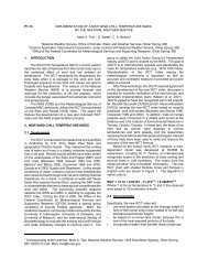
In figure 1 the streamline plot in the Salt Lake City<br />
area shows the general downslope winds at 1200<br />
UTC on 16 May 2007. The forecasted winds are<br />
generally variable in the valley as the model does<br />
respond to some of the smaller-scale features<br />
which act as obstacles to the overall flow. At<br />
1200 UTC the wind reported at the SLC airport<br />
was from 140 degrees at 9 knots although the<br />
forecasted winds at the airport are backed more to<br />
a 090 direction.
Fig 1. 1200 UTC May 16, 2007 wind flow centered in the SLC valley/<br />
By 1600 UTC, as seen in figure 2, the overall<br />
surface wind flow near the mountain range are<br />
variable in direction with some hints of upslope<br />
flow starting in the southeast part of SLC with<br />
smaller eddies forecasted near the southeast<br />
corner of the grid which is close to the airport. At<br />
1600 UTC the SLC airport was reporting variable<br />
winds at 3 knots. Meanwhile, as the surface<br />
became warmer, the wind on the lake had<br />
responded and the forecasted winds on the<br />
southern part of the lake had shifted to the north.<br />
By 1900 UTC, the general forecasted winds are<br />
from the lake into the city as seen in figure 3. The<br />
forecasted winds near the airport are from 340<br />
degrees. At 1900 UTC, the observation at SLC<br />
was 340 degrees at 8 knots.
Figure 2 -- 1600 UTC 16 May 2007 wind flow in Salt Lake Basin<br />
Figure 3: 1900 UTC, 16 May 2007 wind flow in the SLC region
5. SUMMARY AND CONCLUSIONS<br />
The WRF-ARW was run at Salt Lake City<br />
initialized with 0000 (UTC) 40-km ETA model data<br />
for a period of 24 hours with model output<br />
available every hour. A two-nest configuration was<br />
used, with the outer domain having 8-km grid<br />
resolution and the inner domain having a 2-km<br />
grid resolution, although the recent runs used a<br />
three nest configuration of 18-km, 6-km, and 2-km<br />
grid resolutions as seen in figures 1-3. Model<br />
evaluation was conducted just southeast of<br />
downtown SLC and showed larger errors than<br />
other WRF evaluation studies. Given the terrain<br />
issues and the complex wind flow in this area,<br />
these results are not unexpected. The general<br />
trend is for the model to underforecast the<br />
temperature and dew points over the 24-h<br />
forecast period with a bias to underforecast the<br />
wind speeds.<br />
Given the complex terrain, the wind flow was<br />
considered to be the WRF’s most vital challenge.<br />
If any trend was noted it was that the model went<br />
too quickly to the drainage flow rather than taking<br />
into the consideration the winds from the more<br />
dominating synoptic seasonal winds from the west<br />
or from the south to north in the valley. During the<br />
entire 24-h evaluation forecast period the model<br />
overforecasted the drainage winds from the east<br />
and underforecasted the downslope winds from<br />
the west. The lake breeze only occurred in 11<br />
percent of the cases and the model forecasted it<br />
with skill on most occasions as can be seen in the<br />
sequence of figures shown in section 4.<br />
One of more interesting results, this apparent<br />
model error of having the WRF shifting the winds<br />
at the initial period and again too quickly reversing<br />
from a westerly flow to easterly flow at 24-h,<br />
should be an area of future study. It is uncertain if<br />
this is a localized problem, one likely to occur in<br />
complex terrain, or a known WRF bias. It could be<br />
an issue of boundary-layer processes or<br />
parameterization. Future studies will include a<br />
more detailed study of local fluxes and to see how<br />
WRF interactions in the boundary layer respond to<br />
different parameters.<br />
6. REFERENCES<br />
Banta, R. M., L. S. Darby, B. W. Orr, and C.-J.<br />
Zhu. 2002. "Down-Basin Drainage Jet Observed<br />
During VTMX: Large-Scale Controls and Effects<br />
on Local-Scale Flows." In Preprints, 10th<br />
Conference on Mountain Meteorology and MAP<br />
Meeting 2002, June 17-21, 2002, Park City, Utah<br />
(1 pg).<br />
Doran, J.C., J.D. Fast, and J. Horel, 2002: The<br />
VTMX 2000 campaign, Bull. Amer. Meteor. Soc.,<br />
83, 537-551.<br />
Utah Department of Environmental Quality,<br />
Division of Air Quality.<br />
http://www.airmonitoring.utha.gov/ (accessed 19<br />
October 2006)<br />
Whiteman, C. D. 2000. Mountain Meteorology:<br />
Fundamentals and Applications. Oxford University<br />
Press, New York, 355 pp.<br />
Zumpfe, D.E. and J.D. Fast, 2007: Lake Breeze<br />
Fronts in the Salt Lake Valley, J. Appl. Meteor.,<br />
46, 196-211.