The NPOESS Data Exploitation (NDE) Project - AMS supported ...
The NPOESS Data Exploitation (NDE) Project - AMS supported ...
The NPOESS Data Exploitation (NDE) Project - AMS supported ...

Create successful ePaper yourself
Turn your PDF publications into a flip-book with our unique Google optimized e-Paper software.
NOAA’s <strong>NPOESS</strong> <strong>Data</strong> <strong>Exploitation</strong> <strong>Project</strong>: Re-usable Tools and Services<br />
Geof Goodrum* 1 , Jim Yoe 1 , Jim Silva 1 , Gary Roth 2 , Peter MacHarrie 2 , and Raj Khanna 3<br />
1 NOAA/NESDIS, Suitland, Maryland<br />
2<br />
Dell Perot Systems Government Services, Suitland, Maryland<br />
3 Noblis, Falls Church, Virginia<br />
1. INTRODUCTION<br />
<strong>The</strong> <strong>NPOESS</strong> <strong>Data</strong> <strong>Exploitation</strong> (<strong>NDE</strong>) <strong>Project</strong> is<br />
building a near-real time data processing and<br />
distribution system to provide operational civilian<br />
users with observations from the National Polarorbiting<br />
Operational Environmental Satellite<br />
System (<strong>NPOESS</strong>) and its risk-reduction<br />
forerunner, NASA’s <strong>NPOESS</strong> Preparatory<br />
<strong>Project</strong> (NPP). <strong>The</strong> <strong>NDE</strong> <strong>Project</strong> has diverse<br />
user requirements for atmospheric,<br />
oceanographic, and land surface data products<br />
with strict operational timeliness. <strong>The</strong> <strong>NDE</strong><br />
system design meets these user requirements<br />
by employing a Service Oriented Architecture<br />
(SOA) in which data ingest, product generation<br />
and tailoring tools, and distribution functions are<br />
presented as internal service components. This<br />
approach reduces redundancy and provides<br />
scalability and high availability for mission critical<br />
operations, while maintaining flexibility to meet<br />
future requirements for products, data<br />
processing, and distribution. In addition, the<br />
<strong>NDE</strong> <strong>Project</strong> has worked with stakeholders to<br />
promote and adopt widely used scientific data<br />
formats consistent with the interoperability<br />
objectives for the Global Earth Observation<br />
System of Systems (GEOSS). This paper<br />
reviews the design of the <strong>NDE</strong> system and the<br />
progress made toward its implementation.<br />
2. <strong>NPOESS</strong> Overview<br />
<strong>The</strong> <strong>NPOESS</strong> Program, operated by the<br />
Integrated Program Office, was established to<br />
develop, acquire, and deploy a system of<br />
operational environmental satellites and sensors<br />
that would merge the separate NOAA Polar<br />
Operational Environmental Satellites (POES)<br />
and Defense Meteorological Satellite Program<br />
(DMSP) into a single platform serving both the<br />
* Corresponding author address: Geof<br />
Goodrum, NOAA/NESDIS, Suitland, MD; e-<br />
mail: geoffrey.p.goodrum@noaa.gov.<br />
civilian and military user communities. In<br />
addition, <strong>NPOESS</strong> was designed to provide<br />
continuity for the data sets established by<br />
NASA’s EOS satellite series. <strong>The</strong> key features of<br />
<strong>NPOESS</strong> operations are depicted in Figure 1.<br />
<strong>The</strong>re is a single space segment, consisting of<br />
one or more spacecraft, each bearing a variety<br />
of sensors designed to satisfy the consolidated<br />
data requirements of NASA, NOAA, and the<br />
DoD. <strong>The</strong> initial risk-reduction implementation<br />
will be the NASA-operated NPP mission.<br />
<strong>The</strong> Command, Control and Communications<br />
Segment (C3S) provides capability to send<br />
instructions to the spacecraft and to receive<br />
observations from the sensors via radio<br />
frequency (RF) links. For the NPP mission all<br />
C3S service will be accomplished through a<br />
single ground station located at Svalbard in<br />
Norway. Later a globally distributed series of<br />
receptors designated SafetyNet will be deployed,<br />
reducing the time between observation and data<br />
receipt for processing dramatically and<br />
facilitating near-real time application of polar<br />
satellite data.<br />
From the C3S, sensor data will be delivered as<br />
Application Packets (APs) to central processing<br />
sites designated as the Interface <strong>Data</strong><br />
Processing Segment (IDPS). One IDPS<br />
implementation at the National Satellite<br />
Operations Facility (NSOF) under NESDIS will<br />
serve the civilian user communities for both the<br />
NPP and <strong>NPOESS</strong> eras. Another IDPS will be<br />
operated by the Air Force Weather Agency<br />
(AFWA) will provide data to DOD users for NPP<br />
and <strong>NPOESS</strong>. Two more IDPS facilities to<br />
supply the US Navy operational centers are<br />
planned for the <strong>NPOESS</strong> era. Each IDPS site<br />
will receive the APs and process them into<br />
Sensor <strong>Data</strong> Records (SDRs) and<br />
Environmental <strong>Data</strong> Records (EDRs), using<br />
common algorithms and ancillary data as<br />
necessary to deliver common global data<br />
products in the Hierarchical <strong>Data</strong> Format 5<br />
(HDF5) at each of the four operational centers.
Figure 1: Schematic overview of the <strong>NPOESS</strong> space, communications, and processing segments, and<br />
the flow of a common set of data products from a single suite of on-orbit sensors to multiple operational<br />
centers.<br />
3. <strong>NPOESS</strong> <strong>Data</strong> <strong>Exploitation</strong> (<strong>NDE</strong>)<br />
NOAA’s <strong>NPOESS</strong> <strong>Data</strong> <strong>Exploitation</strong> provides the<br />
sole link between NPP and <strong>NPOESS</strong> and the<br />
civilian real-time data user communities. To<br />
serve these users <strong>NDE</strong> must:<br />
Disseminate <strong>NPOESS</strong> <strong>Data</strong> Records to end<br />
users in the native HDF5 format<br />
Generate and disseminate tailored <strong>NPOESS</strong><br />
<strong>Data</strong> Records (in alternative formats, views,<br />
projections, aggregations, subsets, etc.)<br />
Generate and disseminate NOAA-unique<br />
products (enhanced environmental products<br />
constructed from <strong>NPOESS</strong> <strong>Data</strong> Records,<br />
which use advanced science algorithms to<br />
meet mission requirements unique to<br />
NOAA )<br />
Deliver NOAA-unique products, product<br />
processing elements, and associated<br />
metadata to the NOAA Long-Term Archive<br />
Provide services to customers, including a<br />
Help Desk, <strong>NDE</strong> product training, product<br />
enhancement, and implementation support<br />
across NOAA<br />
Develop a sustainable system that meets its<br />
customer needs<br />
Provide software for <strong>NPOESS</strong> <strong>Data</strong> Record<br />
format conversion and other data<br />
manipulations<br />
This paper describes the tools and services that<br />
will be used to process and disseminate NPP<br />
and <strong>NPOESS</strong> data effectively. <strong>The</strong> data<br />
products themselves are described in a<br />
companion paper [1].
3.1 <strong>NDE</strong> Enterprise Approach<br />
To reduce the time, cost, and risks associated<br />
with the development of the <strong>NDE</strong> system, an<br />
enterprise approach has been adopted, based<br />
on using standardization as much as possible.<br />
A common data handling system (DHS) will be<br />
used to manage and move data within <strong>NDE</strong>,<br />
without regard to the sensor of origin for a given<br />
data granule, or the particular environmental<br />
data “product line” involved. Likewise, a<br />
common tailoring software toolset is being<br />
developed to perform aggregation, spatial,<br />
temporal, and spectral filtering, re-formatting and<br />
map projections. Standard tools and methods<br />
are being used for system and product<br />
development, based on standardized<br />
component technologies including programming<br />
languages, databases, and configuration<br />
management tools.<br />
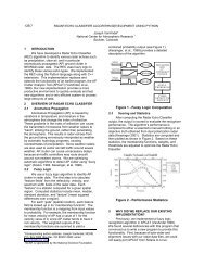
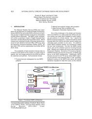
3.2 <strong>NDE</strong> Service Oriented Architecture<br />
Each NPP or <strong>NPOESS</strong> spacecraft will generate<br />
some 4 TB of data daily, far surpassing the data<br />
volumes of current operational polar satellite<br />
systems. Nominal <strong>NDE</strong> data retention is 96<br />
hours, while the IDPS retention (for data<br />
recovery support is 24 hours). To meet the data<br />
processing workload imposed by such large<br />
data volumes, <strong>NDE</strong> will rely on a serviceoriented<br />
architecture, in which common<br />
functions are invoked as services, as illustrated<br />
in Figure 2. <strong>Data</strong> pushed from the IDPS will land<br />
on <strong>NDE</strong>’s Storage Area Network (SAN). <strong>The</strong><br />
Ingest service will detect, check, and register<br />
incoming data. <strong>The</strong> registry will be compared to<br />
Production Rules, so that when requisite files<br />
are present, a trigger message is issued to<br />
invoke the Product Generation Service (PGS).<br />
Narrow arrows in Figure 2 indicate the<br />
transmission of messages, while broad arrows<br />
represent data flows. One objective within the<br />
<strong>NDE</strong> system is to minimize the movement of<br />
large volumes of data, unless doing so<br />
increases the performance within the PGS<br />
enough to offset the overhead associated with<br />
moving the data.<br />
Modular algorithms running as components of<br />
the PGS will generate the NUPs and perform the<br />
product tailoring for all product lines.<br />
Customer Services include the registration of<br />
users authorized to receive <strong>NDE</strong> data products<br />
in near real time, and order management for<br />
users’ product subscriptions. <strong>The</strong> Distribution<br />
service provides supporting notification to<br />
subscribers, for example, when products have<br />
been successfully generated, and ensures that<br />
the products are available for distribution via the<br />
specified protocol for each subscription.<br />
Not shown in Figure 2 is the System Monitoring<br />
and Control service, which encompasses all of<br />
the other services. This service will automatically<br />
monitor logs and reports, and control the other<br />
sub-processes through a central repository<br />
maintained as a Relational <strong>Data</strong>base<br />
Management System.<br />
3.3 <strong>NDE</strong> Interoperability<br />
To facilitate sharing of data and tools for<br />
manipulating data among product development<br />
teams, product area leads, researchers and<br />
operational end users, <strong>NDE</strong> will adhere to NOAA<br />
recommendations for data formatting<br />
conventions [2]. For GIS applications, <strong>NDE</strong> will<br />
support GeoTIFF. For the Numerical Weather<br />
Prediction (NWP) community, <strong>NDE</strong> will provide<br />
key data records in the BUFR and GRIB2<br />
formats to ensure continuity of the beneficial<br />
impact of polar satellite data to operational<br />
forecasting.<br />
To support research and analysis, <strong>NDE</strong> plans to<br />
archive some of the NOAA Unique Products (as<br />
determined by management review). <strong>The</strong>se<br />
NUPS will be put in netCDF4 format with the<br />
Climate and Forecasting (CF) conventions, or<br />
HDF5 as required. <strong>The</strong> <strong>NDE</strong> Tailoring Tools and<br />
associated documentation will be made<br />
available to users through the archive as well.<br />
NOAA CLASS provides the IT infrastructure for<br />
the long term archive of NPP and <strong>NPOESS</strong> data<br />
and metadata, and <strong>NDE</strong> tools.
Figure 2: Schematic diagram of <strong>NDE</strong> Service Oriented Architecture<br />
3.4 Implementation Schedule<br />
<strong>The</strong> development of the <strong>NDE</strong> software and<br />
hardware infrastructure is being performed<br />
though a series of subsystem builds, beginning<br />
with Ingest and adding Product Generation,<br />
Distribution, Customer Services, and finally<br />
System Monitoring and Control. <strong>The</strong> schedule<br />
completing each of these builds is shown in<br />
Figure 3. <strong>NDE</strong> has been working to a launch<br />
date of January 16, 2011 for NPP, by which time<br />
limited distribution capability sufficient to supply<br />
high priority data products to key users [for<br />
example, sounder radiances to support NOAA’s<br />
Numerical Weather Prediction (NWP) enterprise]<br />
will be in place, and system performance testing<br />
of Ingest, Production, and Distribution will be in<br />
progress. <strong>The</strong> Customer Services and System<br />
Monitoring capabilities will not be developed,<br />
tested, and integrated until after launch.<br />
Following implementation and testing of all <strong>NDE</strong><br />
subsystems supporting NPP, the system will be<br />
transferred to operations, and the <strong>NDE</strong> team will<br />
repeat the build cycle in support of <strong>NPOESS</strong>,<br />
incorporating the lessons learned in preparing<br />
for NPP.
Figure 3: <strong>NDE</strong> Software Build Schedule to support processing and distribution of NPP data<br />
4. <strong>NDE</strong> DATA USER INTEGRATION<br />
<strong>The</strong> advanced sensors developed for <strong>NPOESS</strong><br />
and NPP will be used to generate a larger<br />
number of more varied polar data products than<br />
their forerunners. Moreover, many of these<br />
products will be of significantly improved<br />
precision, accuracy, and resolution (temporal,<br />
spatial, and spectral), and with the<br />
implementation of SafetyNet, delivered much<br />
more rapidly.<br />
<strong>The</strong>se changes indicate new applications and<br />
users for NPP and <strong>NPOESS</strong> data, and<br />
significant changes for current polar satellite<br />
data users. <strong>NDE</strong> will form Stakeholder<br />
Integration Teams (SITs) within NOAA to help<br />
end users prepare to use the enhanced data<br />
products and the tools and services provided by<br />
<strong>NDE</strong>. Analysis of end user systems will be<br />
performed to identify necessary upgrades,<br />
develop test procedures and transition plans,<br />
and to identify training needs. <strong>The</strong> initial <strong>NDE</strong><br />
Stakeholder Integration Team will support<br />
NOAA’s operational NWP capability using NPP<br />
sounder radiance data, working in collaboration<br />
with the Joint Center for Satellite <strong>Data</strong><br />
assimilation, the Center for Satellite Applications<br />
and Research, and the Environmental Modeling<br />
Center. Other SITs will support the NOAA<br />
CoastWatch community, and users of the<br />
Advanced Weather Interactive Processing<br />
System (AWIPS).<br />
5. SUMMARY<br />
<strong>NDE</strong> will provide the sole link between real-time<br />
civilian data users and the NPP and <strong>NPOESS</strong><br />
satellite data. An enterprise approach featuring<br />
re-usable tools and services is being used to<br />
lower the cost, time, and risk associated with the<br />
development the <strong>NDE</strong> systems. This approach<br />
is based on a Service-Oriented Architecture that<br />
performs tasks as common services, and which<br />
is developed as a series of builds that integrate<br />
successive subsystems and services into the<br />
system. <strong>NDE</strong> ingest, product generation, and<br />
distribution services will be ready to support<br />
delivery of high priority data to key users as<br />
soon as possible after NPP launch.<br />
6. REFERENCES<br />
[1] NOAA’s Near-Real Time <strong>Data</strong> Products from<br />
NPP and <strong>NPOESS</strong>, Schott, T., S. Bunin, J. Yoe,<br />
J. Silva, and G. Goodrum, <strong>AMS</strong> 90 th Annual<br />
Meeting, Atlanta, GA, January 2010.<br />
[2]https://www.nosc.noaa.gov/dmc/swg/wiki/inde<br />
x.php?title=Standards_White_Paper.