Extended Abstract
Extended Abstract
Extended Abstract

You also want an ePaper? Increase the reach of your titles
YUMPU automatically turns print PDFs into web optimized ePapers that Google loves.
(P-443)<br />
1. INTRODUCTION<br />
INUNDATION MAPPING EMPLOYING HYDRAULIC MODELING AND GIS:<br />
CASE STUDY TAR RIVER DURING HURRICANE FLOYD<br />
Keren J. Cepero-Pérez 1 , J. P. Liu 1 , Sean Reed 2 , Cecile Aschwanden 2-3<br />
Storm induced flooding event is a major<br />
concern in many regions of the world (M.R. Knebl et al.<br />
2005). Annually in the United States, this natural<br />
hazard causes $6 billion in losses, 160 deaths,<br />
damage to infrastructure and economic disruption<br />
(USGS, 2006). In order to reduce the effects of this<br />
natural hazard, emergency responders, policy makers<br />
and general public need accessible, simple and clear<br />
information. Previous studies have shown that<br />
hydraulic models and GIS are efficient tools to develop<br />
inundation maps (D.Z. Sui, 1999; Aschwanden, 2008).<br />
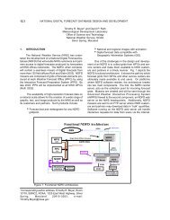
As part of an effort to help mitigate the effects of these<br />
kinds of events, the National Weather Service (NWS)<br />
recently began to provide static inundation maps<br />
developed at selected river forecast points through the<br />
Advanced Hydrologic Prediction Service (AHPS) web<br />
pages (http://www.weather.gov/oh/ahps/). Additionally,<br />
NWS is in the process of integrating the US Army<br />
Corps of Engineers (USACE) Hydrologic Engineering<br />
Center-River Analysis System (HEC-RAS) software<br />
into the NWS Community Hydrologic Prediction<br />
System (CHPS). HEC-RAS is designed to perform<br />
one-dimensional hydraulic calculations for a full<br />
network of natural and constructed channels (Brunner,<br />
G. W. 2006).<br />
1 North Carolina State University, Marine Earth and<br />
Atmospheric Sciences Dept. Box 8208 NCSU Campus,<br />
Raleigh, NC 27695; kjperez@ncsu.edu<br />
2 NOAA,<br />
National Weather Service, Office of<br />
Hydrologic Development, 1325 East-West Highway,<br />
Silver Spring, MD 20910.<br />
3 Wyle Information Systems<br />
North Carolina State University, Raleigh NC<br />
HEC-RAS has the capability of performing the analysis<br />
in steady state (simplistic approach; flow does not<br />
change through time) and unsteady state (More<br />
complex and realistic approach). Use of HEC-RAS<br />
should enable more rapid implementation of new<br />
dynamic hydraulic routing models at forecast points.<br />
We hypothesize that flood forecast maps produced<br />
from real-time, dynamic models will be more accurate<br />
than maps produced using the static mapping<br />
approach. Here we describe a case study designed<br />
to test this hypothesis as well as examine how the<br />
HEC-RAS models perform between calibration points,<br />
since the observations along the river that aid the<br />
model calibration are scarce. We need to understand<br />
the uncertainties adhered to the model and its<br />
resultant flood extent maps in order to deliver clear<br />
information.<br />
In this study, we used Geographic<br />
Information System (GIS) through an ArcMAP 9.2<br />
extension, HEC-GeoRAS. The HEC-GeoRAS<br />
provide the tools to develop and modify HEC-RAS<br />
model geometries as well as to perform flood extent<br />
mapping analysis. We employed this GIS tool to<br />
geo-reference a HEC-RAS model and to facilitate the<br />
mapping processes results analysis. The objective of<br />
this project is to evaluate two HEC-RAS models from a<br />
section of the Tar River basin at Greenville, North<br />
Carolina, during the Hurricane Floyd. One model was<br />
run in steady state mode and another in unsteady<br />
state mode. Then the model results were analyzed<br />
with the HEC-GeoRAS to produce the flood extent<br />
polygons. In terms of how well the model perform<br />
between calibration points we compared in situ<br />
observations with the results obtained from the steady<br />
state HEC-RAS model and found that the accuracy<br />
decreases with distance from the lower boundary
calibration point. Although the comparison of steady<br />
and unsteady modeling results is still in progress, the<br />
preliminary results reinforce our confidence that this<br />
model and the application of GIS can produce valuable<br />
information that can be easily used and understood by<br />
watershed managers, emergency responders, and<br />
land use planners.<br />
2. SPATIAL AND TEMPORAL ATTRIBUTES<br />
2.1 Study Area:<br />
The Tar River is 346 km long and drains an area<br />
of 5,571 km². The Tar River below Tarboro was<br />
modeled with HEC-RAS and flood maps were created<br />
for a small segment of the Tar River Basin at<br />
Greenville, North Carolina (Figure 1). The city of<br />
Greenville in Pitt County is susceptible to flooding<br />
from the Tar River. Greenville is located in the north<br />
central coastal plain region of Eastern North Carolina,<br />
approximately 136.7 km east of Raleigh, North<br />
Carolina’s capital. Greenville is approximately 140.0<br />
km west of the Atlantic Ocean and approximately<br />
426.5 km south of our nation's capital, Washington, DC.<br />
Pitt County has a population of 133,798, and the City<br />
of Greenville has a population of 76,058. Pitt County<br />
has a relatively mild climate and experiences all four<br />
seasons each year. The average summer<br />
temperature is 84 o F while the average winter<br />
temperature is 44 o F. The average yearly rainfall for<br />
Pitt County is approximately 121.9 cm (Greenville<br />
web)<br />
2.2 Rainfall Event:<br />
Hurricane Floyd, which made landfall near Cape<br />
Fear, NC on September 16, 1999, passed near<br />
Greenville and the flood stage was recorded. Floyd<br />
made landfall at Cape Fear, NC dumping another<br />
25.4–50.8 cm of rain east of Interstate 95. In the space<br />
of only two weeks, parts of eastern North Carolina<br />
received up to 76.2 cm of rainfall, or a full 60% of the<br />
121.9 cm yearly average (Colby, 2000). The flood<br />
extent was larger than the 100 year flood plain and in<br />
some sites even exceeded the 500 year flood plain.<br />
3. METHODS<br />
A United States Geological Survey calibrated<br />
HEC-RAS model of the Tar River at Greenville, NC,<br />
were modified employing ArcMap 9.2 and<br />
HEC-GeoRAS in order to produce flood extent maps<br />
for the hurricane Floyd event (Figure 2). The main<br />
modification that was done on this model was to define<br />
the Spatial Reference (NAD 1983 StatePlane NC FIPS<br />
3200Feet). Several steps were needed to complete<br />
this process. The first step was to manually digitize<br />
the Tar River center line, as a shapefile format, utilizing<br />
the HEC-GeoRAS geometry pre-processor tools and<br />
background Aerial Pictures and Digital Topographic<br />
Maps as guidance to indentify the river location.<br />
These images and other data were retrieved from the<br />
NC Department of Transportation GIS website<br />
(http://www.ncdot.org/IT/gis/). The rest of the<br />
shapefiles required by HEC-GeoRAS; river banks,<br />
flow path lines and cross sections, were also created<br />
although the only imported into the HEC-RAS model<br />
was the river centerline. Then some cross-sections<br />
were modified to avoid intersection among other<br />
cross-sections. Subsequently we compared the<br />
hydraulic model geometries with aerial images to verify<br />
the spatial reference accuracy. Since both images<br />
matched well, we proceed to declare the hydraulic<br />
model as geo-referenced (Figure 3). Then we ran the<br />
model and exported the calculated surface water<br />
elevation into the GIS as Xml format and processed<br />
the results with the HEC-GeoRAS mapping tools.<br />
The initial step for the HEC-GeoRAS mapping process<br />
is to transform the HEC-RAS results into GIS format.<br />
Then the bounding polygon was determined, followed<br />
by the water depth calculation, and finally the flood<br />
extent delineation for each water surface elevation<br />
(WSE). We focus this study on the maximum WSE<br />
and the resultant flood extent polygon, which is when<br />
the river stage reached 8.4 m (Figure 4).<br />
4. RESULTS<br />
Inundation maps were produce showing the<br />
calculated flood extent at peak flow during the<br />
Hurricane Floyd event. This flood extent map
compared reasonably well with the maps available at<br />
the AHPS webpage. In terms of how the model<br />
results (steady-state only) compare with the field<br />
observations (High water marks), we have found that<br />
the model is underestimating in average by a foot<br />
(Table 1) and the percentage of error decreases with<br />
distance from the lower river calibration point.<br />
Unfortunately, there are not sufficient High water<br />
marks to produce a reliable statistical analysis<br />
(Figure 5).<br />
5. DISCCUSION AND CONCLUSION<br />
After processing and editing the two models we<br />
have found that the HEC-RAS models are valuable<br />
tools for inundation mapping, if:<br />
The cross-sections cover the entire floodplain.<br />
Although the comparison between the calculated<br />
flood extent maps and the AHPS maps matched<br />
reasonable well some areas that were flooded<br />
did not showed on the HEC-RAS maps since the<br />
river cross-sections were not long enough. It is<br />
key that the geometries of a HEC-RAS model<br />
designed to produce flood mapping analysis<br />
cover the areas vulnerable during extraordinary<br />
events like Hurricane Floyd.<br />
The HEC-RAS models need to be<br />
geo-referenced. Considering that the final<br />
product will be a map, it is crucial that the<br />
hydraulic model is georeferenced from the<br />
beginning in order to reduce the uncertainty<br />
added through the geo-referencing processes.<br />
High resolution elevation data is used for the<br />
flood extent calculations. The high resolution<br />
elevation models produce maps with more<br />
details. This improvement could help on the<br />
evacuation planning and possibly will be the<br />
difference in evacuating whole cities or just areas<br />
more vulnerable to get flooded.<br />
It is crucial to understand how the uncertainties in<br />
the model and the flood analysis affect the final<br />
map in order to identify the possible error along<br />
the map and its flood probabilities. The results<br />
of the comparison between the in situ<br />
observations and the calculated WSE by the<br />
steady-state model suggest that the error<br />
decreases toward the lower calibration point.<br />
This could be related to the type of data that the<br />
models require for the lower boundary which is<br />
the river stage instead of river discharge.<br />
However, more studies are needed in order to<br />
identify the reason of this trend.<br />
Further analysis is needed to complete our<br />
comparison of the steady and unsteady models. We<br />
plan to compare the inundated area from the steady<br />
flow model generated with the flood peak flow to the<br />
maximum inundated area at each cross-section<br />
produced by the unsteady flow model.<br />
With the possibility of increasing frequency and<br />
intensity of rainfall events with climate changes,<br />
increasing populations and the associated land use<br />
changes in coastal areas, it is becoming more<br />
important to develop accurate models that will predict<br />
the effects of rain events for both emergency<br />
management and development planning. Although<br />
there is still research needed in order to accurately<br />
take into account the different uncertainties and how<br />
they affect the flood extent maps, this approach<br />
employing hydraulic model and GIS has proved to be a<br />
great tool which can produced simple and clear data<br />
for the public.<br />
6. AKNOWLEDGEMENTS<br />
This study has been possible with the<br />
collaboration of the Hydraulic Group of NOAA, NWS,<br />
Office of Hydrologic Development which is directed by<br />
directed by Seann Reed and the NOAA<br />
Interdisciplinary Scientific Environmental Technology<br />
program.
7. REFERENCES<br />
Aschwanden, C., Reed S. and Cepero K. 2009<br />
Inundation Mapping Using Hydraulic Models and<br />
GIS: Case Studies of Steady and Unsteady<br />
Models on the Tar River, NC. World<br />
Environmental and Water Resources Congress<br />
2009: Great Rivers. pp. 1-10<br />
Brunner, G. W. 2006. HEC-RAS River Analysis<br />
System User’s Manual (Version 4.0 Beta). US<br />
Army Corps of Engineers Hydrologic Engineering<br />
Center (HEC).<br />
Colby, J. D., Mulcahy, K., and Wang, Y.,<br />
2000,Modeling flooding extent from Hurricane<br />
Floyd in the coastal plains of North Carolina.<br />
Environmental Hazard, 2,157–168.<br />
M.R. Knebl, Z.-L. Yang, K. Hutchison, D.R. Maidment,<br />
2005. Regional scale flood modeling using<br />
NEXRAD rainfall, GIS, and HEC-HMS/RAS: a<br />
case study for the San Antonio River Basin<br />
Summer 2002 storm event, Journal of<br />
Environmental Management 75, 4, Pages<br />
325-336.<br />
Sui, D.Z. and Maggio, R.C., 1999. Integrating GIS with<br />
hydrological modeling: practices, problems and<br />
prospects. Computers, Environment and Urban<br />
Systems 23 1, pp. 33–51.<br />
United State Geological Survey, 2006. Fact Flood<br />
Hazards - A National Threat, Fact Sheet.<br />
2006-3026<br />
NOAA National Weather Service, Advance Hydrologic<br />
Prediction Service, website<br />
http://www.weather.gov/oh/ahps/<br />
Greenville, NC (2009) website<br />
http://www.greenvillenc.gov<br />
8. ILUSTRATIONS AND TABLES<br />
Figure 1: Tar River Basin, NC.<br />
Figure 2: Screen preview of the USGS calibrated<br />
HEC-RAS model geometries for the<br />
Tar River at Greenville,<br />
NC (before geo-referenced).<br />
Figure 3: Screen preview of the USGS calibrated HEC-RAS<br />
model geometries for the Tar River at Greenville, NC (after<br />
geo-referenced).
Figure 4: Cross-section view for Tar River HEC-RAS model<br />
at peak flow (8.2 m) during Hurricane Floyd.<br />
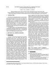
% Difference<br />
7<br />
6<br />
5<br />
4<br />
3<br />
2<br />
1<br />
0<br />
R 2 = 0. 75<br />
24 26 28 30 32 34 36<br />
Di s t anc e f r om calibration poi nt ( km)<br />
Figure 5: This line is showing how the Percentage of Error<br />
Increases with distance from the Lower Boundary Calibration<br />
Point in the Tar River Steady-state HEC-RAS model.<br />
Table 1: This table illustrates the summary of the high water<br />
marks (HWM) and the HEC-RAS Water Surface Elevation<br />
(WSE) comparison. According to this data the average error<br />
presented by the model is 0.3 m.<br />
Distance HWM<br />
(m)<br />
HEC-RAS<br />
WSE (m)<br />
Error % Error<br />
25.08 7.0 7.1 0.1 1.1<br />
25.08 7.4 7.4 0.0 0.4<br />
28.43 7.6 7.6 0.1 -0.8<br />
31.84 8.2 7.9 0.3 -3.5<br />
31.86 8.4 8.0 0.4 -4.4<br />
32.17 8.4 8.0 0.4 -4.3<br />
32.39 8.6 8.1 0.5 -6.1<br />
32.39 8.3 8.1 0.2 -2.7<br />
33.36 8.7 8.2 0.5 -5.5<br />
33.36 8.7 8.2 0.5 -5.4<br />
33.71 8.7 8.4 0.4 -4.5<br />
35.50 8.9 8.4 0.5 -5.1