National Digital Forecast Database design and development - NOAA
National Digital Forecast Database design and development - NOAA
National Digital Forecast Database design and development - NOAA

You also want an ePaper? Increase the reach of your titles
YUMPU automatically turns print PDFs into web optimized ePapers that Google loves.
12.3 NATIONAL DIGITAL FORECAST DATABASE DESIGN AND DEVELOPMENT<br />
1. INTRODUCTION<br />
The <strong>National</strong> Weather Service (NWS) has undertaken<br />
the <strong>development</strong> of a <strong>National</strong> <strong>Digital</strong> <strong>Forecast</strong> <strong>Database</strong><br />
(NDFD) that will enable NWS customers <strong>and</strong> partners<br />
access to digital forecasts produced by forecasters<br />
at NWS offices nationwide. The NDFD, when complete,<br />
will contain a seamless mosaic of digital forecasts from<br />
more than 120 field offices (Ruth <strong>and</strong> Glahn 2003). NDFD<br />
mosaics are composed of grids of forecast elements produced<br />
at each Weather <strong>Forecast</strong> Office (WFO) by using<br />
the Interactive <strong>Forecast</strong> Preparation System (IFPS). By<br />
late 2003, IFPS will be implemented at all NWS WFOs<br />
(Ruth 2002).<br />
The availability of high-resolution forecast data on<br />
a national scale allows for the creation of a wide range of<br />
graphic, text, <strong>and</strong> image products by the NWS as well as<br />
its customers <strong>and</strong> partners. Such products include:<br />
• <strong>Forecast</strong> text <strong>and</strong> meteograms for any NDFD<br />
gridpoint.<br />
WFO<br />
(128)<br />
RFC<br />
(13)<br />
NCEP<br />
(6)<br />
REGIONAL<br />
OFFICES<br />
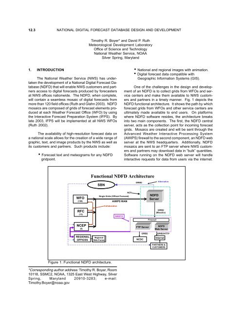
Figure 1: Functional NDFD architecture.<br />
*Corresponding author address: Timothy R. Boyer, Room<br />
10118, SSMC2, <strong>NOAA</strong>, 1325 East West Highway, Silver<br />
Spring, Maryl<strong>and</strong> 20910-3283; e-mail:<br />
Timothy.Boyer@noaa.gov<br />
Timothy R. Boyer* <strong>and</strong> David P. Ruth<br />
Meteorological Development Laboratory<br />
Office of Science <strong>and</strong> Technology<br />
<strong>National</strong> Weather Service, <strong>NOAA</strong><br />
Silver Spring, Maryl<strong>and</strong><br />
Functional NDFD Architecture<br />
SBN<br />
NCF<br />
Single Grids (Official <strong>Forecast</strong>)<br />
Regional<br />
Web Farms<br />
Collaboration<br />
AWIPS WAN<br />
NWSTG<br />
• <strong>National</strong> <strong>and</strong> regional images with animation.<br />
• <strong>Digital</strong> forecast data compatible with<br />
Geographic Information Systems (GIS).<br />
One of the challenges in the <strong>design</strong> <strong>and</strong> <strong>development</strong><br />
of an NDFD is to collect grids from WFOs <strong>and</strong> service<br />
centers <strong>and</strong> make them available to NWS customers<br />
<strong>and</strong> partners in a timely manner. Fig. 1 depicts the<br />
NDFD functional architecture. It shows the path by which<br />
forecast grids from WFOs <strong>and</strong> other service centers are<br />
ultimately made available to end users. On platforms<br />
where NDFD software resides, the architecture breaks<br />
into two main components. The first, the NDFD central<br />
server, acts as the collection point for incoming forecast<br />
grids. Mosaics are created <strong>and</strong> will be sent through the<br />
Advanced Weather Interactive Processing System<br />
(AWIPS) firewall to the second component, an NDFD web<br />
server at the NWS headquarters. Additionally, NDFD<br />
mosaics are sent to an FTP server where NWS customers<br />
<strong>and</strong> partners may download data in “bulk” quantities.<br />
Software running on the NDFD web server will h<strong>and</strong>le<br />
interactive requests for data from users via the internet.<br />
GRIB2<br />
FTP Server<br />
NCDC<br />
NDFD<br />
Server<br />
Alternative<br />
GRIB2<br />
(Mosaics)<br />
<br />
Firewall<br />
<br />
GRIB2<br />
NDFD<br />
Web Server<br />
GRIB2/HTTP<br />
Internet<br />
PARTNERS &<br />
CUSTOMERS
<strong>Forecast</strong> mosaics made available on the web server are<br />
intended for less intensive but more user-specific data<br />
access. NDFD web server software will also reside at<br />
NWS Regional “web farms” that will function as mirror<br />
sites for NDFD data. At some point in the future, NDFD<br />
mosaics may also be transmitted over the AWIPS Satellite<br />
Broadcast Network (SBN).<br />
This paper describes the process by which digital<br />
forecast data produced at WFOs <strong>and</strong> NWS service centers<br />
is transformed into national-scale products <strong>and</strong> made<br />
available to the public. NDFD software is currently being<br />
developed at the Meteorological Development Laboratory<br />
(MDL) at the NWS headquarters. Images from the<br />
initial prototype of the NDFD were first made available in<br />
March 2002 to a h<strong>and</strong>ful of WFOs participating in the<br />
experiment. By summer 2003, grids from all WFOs in<br />
the conterminous United States (CONUS) will be available<br />
experimentally.<br />
2. THE NDFD CENTRAL SERVER<br />
When forecasters are prepared to publish their latest<br />
forecast grids to the NDFD, IFPS software at the WFO<br />
encodes the grids in GRIdded Binary data format (GRIB)<br />
prior to transmission to the NDFD central server via the<br />
AWIPS WAN. Only grids that have been updated since<br />
the last transmission are sent by the WFO. Decoding<br />
software on the NDFD server unpacks the encoded grids<br />
<strong>and</strong> stores the data to a Relational <strong>Database</strong> Management<br />
System (RDBMS). A decoder process kicks off once every<br />
5 minutes on the NDFD server. This allows the NDFD to<br />
be updated on a near-continuous basis with forecasts<br />
from WFOs <strong>and</strong> service centers. Every grid received is<br />
stored into the database as a unique entity. In addition<br />
to the actual data, metadata such as geographical<br />
location, grid valid time <strong>and</strong> forecast issuance time are<br />
stored. Issuance time for a forecast grid is the time at<br />
which a WFO wants that grid to become the official<br />
forecast.<br />
NDFD mosaics are created on a routine basis (currently,<br />
once an hour) from individual WFO grids stored in<br />
the database. For each weather element, at every forecast<br />
projection, the database is searched for new WFO<br />
grids. If a new WFO grid is found, that grid’s issuance<br />
time is compared to the current time. If the issuance<br />
time has been reached, the grid is added to the appropriate<br />
mosaic. The AWIPS 227 grid with 5-km grid mesh<br />
length is the grid upon which NDFD mosaics are based.<br />
Mosaics lie on a sub-domain of this grid, with a size of<br />
1073x689 gridpoints. An identification grid that maps<br />
the domain of every WFO to the NDFD grid is used to<br />
produce mosaics. Each mosaic is stored to the RDBMS<br />
after it has been created or updated.<br />
Another process runs on the NDFD central server<br />
that checks consistency of forecasts between neighboring<br />
WFOs. Overlapping gridpoints along WFO boundaries<br />
are analyzed for each weather element grid <strong>and</strong> forecast<br />
values are compared to predetermined discrepancy<br />
thresholds. Gridpoints where thresholds are exceeded<br />
are flagged <strong>and</strong> used to compute forecast consistency<br />
statistics. Additionally, consistency images are generated<br />
that display discrepancies for overlapping points along<br />
WFO boundaries (Fig. 2).<br />
Figure 2: NDFD Mosaic of MaxT <strong>and</strong> an image of discontinuities along WFO boundaries for the mid-Atlantic sector.
Once all mosaics have been produced for a given<br />
issuance of the NDFD, they are encoded in GRIB format.<br />
The encoded grids are transmitted to an FTP server <strong>and</strong><br />
an NDFD web server at the NWS Telecommunications<br />
Gateway (NWSTG). Additionally, mosaics are sent to<br />
the <strong>National</strong> Centers for Environmental Prediction<br />
(NCEP). Encoded NDFD mosaics are created for the<br />
CONUS, <strong>and</strong> also a set of 16 smaller sectors within the<br />
CONUS.<br />
3. NDFD WEB SERVICES<br />
NDFD software will reside on a web server at the<br />
NWS headquarters. Encoded mosaics will be decoded<br />
on the web server as they are received from the NDFD<br />
central server. Unlike the RDBMS on the central server,<br />
the RDBMS on the web server will be configured to store<br />
NDFD data as individual points in the database. Each<br />
gridpoint will be stored as a unique entity with associated<br />
locational, temporal, <strong>and</strong> weather element-specific<br />
metadata. Two critical requirements for the RDBMS on<br />
the web server are optimized capabilities for h<strong>and</strong>ling<br />
geospatial data types as well as the ability to h<strong>and</strong>le the<br />
tremendous load of simultaneous queries expected as<br />
the public begins to access NDFD data.<br />
NDFD web services are <strong>design</strong>ed to give users flexible<br />
access to forecast data while hiding the underlying<br />
implementation of the database. For purposes of data<br />
integrity <strong>and</strong> server security, users are never allowed direct<br />
access to the relational database itself. Table 1 shows<br />
an example of a typical request to the NDFD database<br />
<strong>and</strong> how web services work to provide the data requested<br />
by the user.<br />
Table 1: NDFD Web Services example.<br />
CCCCCllllliiiiieeeeennnnnttttt PPPPPCCCCC<br />
NNNNNDDDDDFFFFFDDDDD WWWWWeeeeebbbbb<br />
SSSSSeeeeerrrrrvvvvviiiiiccccceeeeesssss<br />
wwwwweeeeebbbbb ssssseeeeerrrrrvvvvveeeeerrrrr<br />
RRRRRDDDDDBBBBBMMMMMSSSSS ssssseeeeerrrrrvvvvveeeeerrrrr<br />
( ( ( ( ( ooooonnnnn<br />
w w w w weeeeebbbbb<br />
ssssseeeeerrrrrvvvvveeeeerrrrr)<br />
) ) ) )<br />
Use<br />
APIto<br />
request<br />
NDFD<br />
data<br />
via<br />
SOAP<br />
Receive<br />
SOAP<br />
request<br />
for<br />
data<br />
Validate<br />
request<br />
Formulate<br />
SQL<br />
query<br />
Connect<br />
to<br />
RDBMS<br />
Send<br />
SQL<br />
queryto<br />
RDBMS<br />
Receive<br />
SQL<br />
query<br />
Execute<br />
query<br />
Returndata<br />
to<br />
Web<br />
service<br />
Compress<br />
data<br />
inGRIB2<br />
format<br />
Wrap<br />
GRIB2<br />
message<br />
in<br />
XML<br />
Send<br />
XML<br />
back<br />
to<br />
client<br />
PC<br />
via<br />
SOAP<br />
APIunwraps<br />
XML<br />
APIdecodes<br />
GRIB<br />
to<br />
raw<br />
data<br />
Client<br />
build<br />
product<br />
withraw<br />
data<br />
Initially, a user makes a request to obtain data by<br />
using an Application Programmer Interface (API) that resides<br />
on the user’s platform. The query is generated by<br />
the API <strong>and</strong> sent to the NDFD web server via a Simple<br />
Object Access Protocol (SOAP) request. The SOAP request<br />
is received at the web server <strong>and</strong> checks are made<br />
to validate the request. This validation ensures, among<br />
other things, that the request makes sense <strong>and</strong> is not<br />
excessively large. Once the request passes validation, a<br />
Structured Query Language (SQL) comm<strong>and</strong> is generated<br />
to fetch the user-requested data from the RDBMS.<br />
Prior to returning the data to the user, the data are<br />
compressed into GRIB format <strong>and</strong> the entire set of data<br />
is wrapped in an eXtensible Markup Language (XML) message.<br />
An API on the user platform unwraps <strong>and</strong> decodes<br />
the data, making it available for user-defined applications.<br />
NDFD web services will allow data to be quickly <strong>and</strong> easily<br />
obtained for user-specified geographic regions, time<br />
ranges, <strong>and</strong> weather elements. They also provide a st<strong>and</strong>ardized<br />
method to query <strong>and</strong> retrieve data from the<br />
NDFD.<br />
4. FUTURE PLANS<br />
Design <strong>and</strong> <strong>development</strong> of NDFD software is an<br />
ongoing effort at MDL. Current tasks include the addition<br />
of non-CONUS areas (e.g., Alaska <strong>and</strong> Hawaii). These<br />
regions must be uniquely h<strong>and</strong>led within the <strong>design</strong><br />
framework of the NDFD due to their size <strong>and</strong> differing<br />
grid definitions. In the future, the NDFD will also include<br />
grids of 3-dimensional aviation forecast elements. A<br />
software improvement that may be implemented is the<br />
addition of a geospatial-type database on the NDFD<br />
central server for increased mosaic generation<br />
performance. Examples of APIs used to access NDFD<br />
data via web services will be provided to NWS customers<br />
<strong>and</strong> partners to promote end-user <strong>development</strong> of<br />
applications that take advantage of this growing wealth<br />
of available data. Through the high-resolution digital<br />
forecast data contained within the NDFD, the NWS will<br />
give its customers <strong>and</strong> partners increasing access to one<br />
of its primary assets, the knowledge <strong>and</strong> experience of<br />
its forecasters.<br />
5. REFERENCES<br />
Ruth, D. P., 2002: Interactive <strong>Forecast</strong> Preparation -<br />
The Future Has Come, Preprints Interactive Symp.<br />
on AWIPS, Orl<strong>and</strong>o, Amer. Meteor. Soc., 20-22.<br />
_____, D. P., <strong>and</strong> H. R. Glahn, 2003: Creating a <strong>National</strong><br />
<strong>Digital</strong> <strong>Forecast</strong> <strong>Database</strong> of Official <strong>National</strong><br />
Weather Service <strong>Forecast</strong>s. Preprints 19th Int. Conf.<br />
on Interactive Information <strong>and</strong> Processing Systems<br />
for Meteorology, Oceanography, <strong>and</strong> Hydrology,<br />
Long Beach, Amer. Meteor. Soc., elsewhere in this<br />
volume.